191 Soil Degradation.pdf - Richmond School District No. 38
191 Soil Degradation.pdf - Richmond School District No. 38
191 Soil Degradation.pdf - Richmond School District No. 38

Create successful ePaper yourself
Turn your PDF publications into a flip-book with our unique Google optimized e-Paper software.
<strong>Soil</strong> degradation – a creeping concern<br />
Geo Factsheet<br />
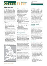
Case Study 2: Land degradation in Barbados<br />
The most significant area of land degradation in Barbados is<br />
within the Scotland <strong>District</strong> (Fig. 4) which falls within the<br />
parishes of St. Andrew, St. Joseph and St. John. This area<br />
represents 14% of the island’s topography and is geologically<br />
unique, since it is the only area on the island where the<br />
limestone cap has been removed. Changing land use practices<br />
and the application of inappropriate agricultural techniques<br />
(growing sugar cane on very steep slopes, for example) have<br />
also resulted in significant and visible loss of soils in the<br />
limestone areas of the island. The Scotland <strong>District</strong> is<br />
particularly prone to landslides and slippage because of its<br />
elevation and soil structure. The soil in this area comprises<br />
clays and shales.<br />
Causes of land degradation<br />
• The reduction of the natural vegetative cover which renders<br />
the topsoil more susceptible to erosion.<br />
• Unsustainable land use practices such as excessive<br />
irrigation, the inappropriate use of fertilisers and pesticides<br />
and overgrazing by livestock.<br />
Fig. 4 The Scotland <strong>District</strong><br />
N<br />
Speightstown<br />
Holetown<br />
Bridgetown<br />
0 km 5000<br />
Key:<br />
ST. ANDREW<br />
Degraded<br />
land<br />
ST. JOSEPH<br />
ST. JOHN<br />
The removal of vegetation and topsoil has resulted in:<br />
• Increased surface runoff and stream discharge<br />
• Reduction of water infiltration and groundwater recharge<br />
• Development of erosionial gullies and sand dunes<br />
• Change in the surface microclimate that enhances aridity<br />
• Drying up of wells and springs, and<br />
• Reduction of seed germination of native plants<br />
Controlling land degradation<br />
One of the most effective ways in which land degradation can be<br />
controlled is through increasing the vegetative cover within the<br />
affected area. The <strong>Soil</strong> Conservation Unit located within the<br />
Scotland <strong>District</strong> is involved in educating farmers about<br />
sustainable farming practices. The farmers are taught methods<br />
which include keeping the soil covered, incorporating organic<br />
matter to assist with percolation and reducing the use of fertilisers.<br />
Managing soil degradation<br />
Abatement strategies, such as afforestation, for combating<br />
accelerated soil erosion are lacking in many areas. To reduce the<br />
risk of soil erosion, farmers are encouraged towards more extensive<br />
management practices such as organic farming, afforestation,<br />
pasture extension and benign crop production. Nevertheless, there<br />
is a need for policy makers and the public to intensify efforts to<br />
combat the pressures and risks to the soil resource.<br />
Methods to reduce or prevent erosion can be mechanical, e.g.<br />
physical barriers such as embankments and wind breaks, or they<br />
may focus on vegetation cover and soil husbandry. Overland flow<br />
can be reduced by increasing infiltration.<br />
Mechanical methods include bunding, terracing and contour<br />
ploughing, and shelterbelts such as trees or hedgerows. The key is<br />
to prevent or slow the movement of rain water downslope.<br />
Contour ploughing takes advantage of the ridges formed at right<br />
angles to the slope to act to prevent or slow the downward<br />
accretion of soil and water. On steep slopes and in areas with<br />
heavy rainfall, such as the monsoon in South-East Asia, contour<br />
ploughing is insufficient and terracing is undertaken.<br />
The slope is broken up into a series of flat steps, with bunds (raised<br />
levees) at the edge. The use of terracing allows areas to be cultivated<br />
that would not otherwise be suitable. In areas where wind erosion is a<br />
problem shelterbelts of trees or hedgerows are used. The trees act as a<br />
4<br />
barrier to the wind and disturb its flow. Wind speeds are reduced which<br />
therefore reduce its ability to disturb the topsoil and erode particles.<br />
Preventing erosion by different cropping techniques largely<br />
focuses on:<br />
• Maintaining a crop cover for as long a possible<br />
• Keeping in place the stubble and root structure of the crop<br />
after harvesting<br />
• Planting a grass crop. Grass roots bind the soil, minimising the<br />
action of the wind and rain on a bare soil surface. Increased<br />
organic content allows the soil to hold more water, this<br />
preventing aerial erosion and stabilising the soil structure. In<br />
addition, care is taken over the use of heavy machinery on wet<br />
soils and ploughing on soil sensitive to erosion, to prevent<br />
damage to the soil structure.<br />
There are three main approaches in the management of salt<br />
affected soils:<br />
1 Flushing the soil and leaching the salt away<br />
2 Application of chemicals, e.g. gypsum (calcium sulphate) to<br />
replace the sodium ions on the clay and colloids with calcium ones.<br />
3 A reduction in evaporation losses to reduce the upward<br />
movement of water in the soil.<br />
Equally specialist methods are needed to decontaminate land<br />
made toxic by chemical degradation.