191 Soil Degradation.pdf - Richmond School District No. 38
191 Soil Degradation.pdf - Richmond School District No. 38
191 Soil Degradation.pdf - Richmond School District No. 38

Create successful ePaper yourself
Turn your PDF publications into a flip-book with our unique Google optimized e-Paper software.
G<br />
eo<br />
F<br />
actsheet<br />
January 2006 www.curriculum-press.co.uk Number <strong>191</strong><br />
SOIL DEGRADATION – A CREEPING CONCERN<br />
Introduction<br />
<strong>Soil</strong> degradation is the decline in quantity and quality of soil. It includes:<br />
• Erosion by wind and water<br />
• Biological degradation (the loss of humus and plant/animal life)<br />
• Physical degradation (loss of structure, changes in permeability)<br />
• Chemical degradation (acidification, declining fertility,<br />
changes in pH, salinisation and chemical toxicity.<br />
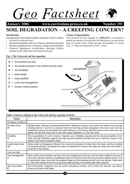
Fig. 1 The Universal soil loss equation<br />
Causes of degradation<br />
The Universal soil loss equation A = RKLSCP is an attempt to<br />
predict the amount of erosion that will take place in an area on the<br />
basis of certain factors which increase susceptibility to erosion<br />
(Fig. 1). These are discussed in Table 1 below.<br />
A = the predicted soil loss<br />
R = the climatic erosivity or the rainfall erosivity index<br />
K = soil erodibility<br />
L = slope length<br />
S = slope gradient<br />
C = cover and management<br />
P = erosion control practice<br />
R<br />
precipitation<br />
wind<br />
L<br />
P<br />
mass movement<br />
K<br />
C<br />
S<br />
Table 1 Factors relating to the Universal soil loss equation (USLE).<br />
Factor<br />
Ecological conditions<br />
Erosivity of soil<br />
R<br />
Erodibility<br />
K<br />
Length-slope factor<br />
LS<br />
Land use type<br />
Crop management<br />
C<br />
<strong>Soil</strong> conservation<br />
P<br />
1<br />
Description<br />
Rainfall totals, intensity and seasonal distribution. Maximum erosivity occurs when the rainfall occurs as high<br />
intensity storms. If such rain is received when the land has just been ploughed or full crop cover is not yet<br />
established, erosion will be greater than when falling on a full canopy. Minimal erosion occurs when rains are<br />
gentle, and fall onto frozen soil or land with natural vegetation or a full crop cover.<br />
The susceptibility of a soil to erosion. Depends upon infiltration capacity and the structural stability of soil.<br />
<strong>Soil</strong>s with high infiltration capacity and high structural stability that allow the soil to resist the impact of rain<br />
splash, have lowest erodibility values.<br />
Slope length and steepness influence the movement and speed of water down the slope, and thus its ability<br />
to transport particles. The greater the slope, the greater the erosivity; the longer the slope, the more water is<br />
received on the surface.<br />
Most control can be exerted over the cover and management of the soil, and this factor relates to the type of<br />
crop and cultivation practices. Established grass and forest provide the best protection against erosion, and<br />
of agricultural crops, those with the greatest foliage and thus greatest ground cover are optimal. Fallow land<br />
or crops that expose the soil for long periods after planting or harvesting offer little protection.<br />
<strong>Soil</strong> conservation measures, such as contour ploughing, bunding, use of strips and terraces, can reduce<br />
erosion and slow runoff water.
<strong>Soil</strong> degradation – a creeping concern<br />
Geo Factsheet<br />
Fig. 2 Types and causes of land degradation.<br />
Types of land degradation<br />
Water and wind erosion account for more than 80% of<br />
the 20 million km 2 degraded worldwide.<br />
Chemical<br />
degradation<br />
12%<br />
Wind<br />
erosion<br />
28%<br />
Physical degradation<br />
4%<br />
Water<br />
erosion<br />
56%<br />
Causes of land degradation<br />
Overgrazing and agricultural mismanagement affect more<br />
than 12 million km 2 worldwide. 20% of the world’s pasture<br />
and rangelands have been damaged and the situation is<br />
most severe in Africa and Asia. Huge areas of forest are<br />
cleared for logging, fuelwood, farming or other human uses.<br />
Industry & urbanisation<br />
1%<br />
Agricultural<br />
mismanagement<br />
27%<br />
Deforestation/<br />
fuelwood<br />
consumption<br />
37%<br />
Overgrazing<br />
35%<br />
<strong>Soil</strong> degradation encompasses several issues at various spatial<br />
time scales.<br />
• Water erosion accounts for nearly 60% of soil degradation.<br />
There are many types of erosion including surface-, gully-,<br />
rill- and tunnel-erosion.<br />
• Wind erosion<br />
• Acidification is the change in the chemical composition of the<br />
soil, which may trigger the circulation of toxic metals.<br />
• Groundwater over-abstraction may lead to dry soils, leading<br />
to physical degradation.<br />
• Salt affected soils are typically found in marine-derived<br />
sediments, coastal locations and hot arid areas where capillary<br />
action brings salts to the upper part of the soil. <strong>Soil</strong> salinity has<br />
been a major problem in Australia following the removal of<br />
vegetation in dryland farming.<br />
• Atmospheric deposition of heavy metals and persistent<br />
organic pollutants may make soils less suitable to sustain the<br />
original land cover and land use.<br />
• Climate change will probably intensify the problem. Climate<br />
change is likely to affect hydrology and hence land use.<br />
Climate change, leading to higher average temperature and<br />
changing precipitation patterns, may have three direct impacts on<br />
soil conditions:<br />
• The higher temperatures cause higher decomposition rates of<br />
organic matter. <strong>Soil</strong> organic matter is important as a source of<br />
nutrients and it improves moisture storage.<br />
• More floods will cause more water erosion.<br />
• More droughts will cause more wind erosion.<br />
Human activities<br />
Human activities have often led to degradation of 15% of the<br />
world’s land resources (Table 2). These impacts frequently lead to<br />
reduction in yields. Land conservation and rehabilitation are<br />
essential parts of sustainable agricultural development. While<br />
severely degraded soil is found in most regions of the world, the<br />
negative economic impact of degraded soil may be most severe in<br />
the countries most dependent on agriculture for their incomes.<br />
Table 2 Human activities and their impact on soil<br />
erosion.<br />
Action<br />
Removal of<br />
woodland or<br />
ploughing<br />
established pasture<br />
Cultivation<br />
Grazing<br />
Road or tracks<br />
Mining<br />
Effect<br />
The vegetation cover is removed, roots<br />
binding the soil die and the soil is<br />
exposed to wind and water. Particularly<br />
susceptible to erosion if on slopes.<br />
Exposure of bare soil surface before<br />
planting and after harvesting. Cultivation<br />
on slopes can generate large amounts<br />
of runoff and create rills and gullies.<br />
Overgrazing can severely reduce the<br />
vegetation cover and leave surface<br />
vulnerable to erosion. Grouping of<br />
animals can lead to over-trampling and<br />
creation of bare patches. Dry regions are<br />
particularly susceptible to wind erosion.<br />
Collect water due to reduced infiltration<br />
that can cause rills and gullies to form,<br />
e.g. when the west coast highway was<br />
built in St. Lucia, Tropical Storm Debbie<br />
led to massive erosion as water was<br />
channelled along exposed, bare road.<br />
Exposure of the bare soil. <strong>Degradation</strong><br />
from chemical dumping.<br />
2
<strong>Soil</strong> degradation – a creeping concern<br />
Geo Factsheet<br />
Fig. 3 The state of the world’s soils.<br />
Key:<br />
Areas of serious<br />
concern<br />
Areas of some<br />
concern<br />
Stable terrain<br />
<strong>No</strong>n-vegetated<br />
land<br />
Case Study 1: <strong>Soil</strong> degradation in India<br />
Factors responsible:<br />
• The amount of India’s land area dedicated to cropland has<br />
grown steadily, from 99.3 million hectares in 1950 to almost<br />
170 million hectares, largely due to the Green Revolution. An<br />
additional 12 million hectares fall under the classification of<br />
‘meadows and pasture’and are utilised for animal husbandry.<br />
• India is the fourth largest fertiliser consumer in the world. India<br />
has also increased its consumption of insecticides, herbicides and<br />
fungicides from only a little over 24,000 tonnes in 1971 to over<br />
82,000 tonnes.<br />
• The area of agricultural land under irrigation has continued<br />
its growth, from 32% in 1970 to 43% in 2000. The majority<br />
of this increase has come from increases in water extracted<br />
from groundwater supplies. This is significant because in<br />
many ways, groundwater supplies can be considered a nonrenewable<br />
resource. Finally, the demand for water irrigation<br />
is expected to increase markedly over the next few decades,<br />
in line with population growth.<br />
• Productivity has increased, e.g. rice paddy production has<br />
more than tripled and total grain production has almost<br />
doubled since 1960. However, the increased use of chemical<br />
fertilisers has become a source of concern since a significant<br />
portion of fertiliser and pesticide applied to the soil runs off<br />
into surface water or leaches into groundwater.<br />
• Land affected by water erosion represents nearly half of total<br />
Indian land area, and 80% of degraded land. Most of this<br />
damage is in the form of loss of topsoil. Among the remaining<br />
categories, salinisation, waterlogging and loss of top soil from<br />
wind erosion (the former two resulting from over-irrigation)<br />
are the most common problems. Water erosion and wind<br />
erosion damage can be attributed to inadequate land cover,<br />
whether it be from deforestation, monocropping, overgrazing<br />
or from farming on marginal and land areas.<br />
Table 3 Classification of Indian soil degradation<br />
Classification of<br />
Indian soil degradation<br />
Water erosion<br />
Loss of top soil<br />
Terrain deformation<br />
Wind erosion<br />
Loss of topsoil<br />
Terrain deformation/overblowing<br />
Chemical deterioration<br />
Loss of nutrients<br />
Salinisation<br />
Physical deterioration<br />
Waterlogging<br />
Land not fit for agriculture<br />
<strong>Soil</strong>s with little or no degradation<br />
<strong>Soil</strong>s under natural condition<br />
Total<br />
Area<br />
(Millions Ha)<br />
132.5<br />
16.4<br />
6.2<br />
4.6<br />
3.7<br />
10.1<br />
11.6<br />
18.2<br />
90.5<br />
32.2<br />
328.7<br />
Chemical degradation in the form of loss and leaching is the<br />
result of shortened fallow periods. Only 37% of Indian land<br />
area can be said to be largely free from degradation of any kind,<br />
and degraded land will continue its growth in years to come.<br />
%<br />
40.3<br />
5.0<br />
4.1<br />
1.9<br />
1.1<br />
3.1<br />
3.5<br />
5.5<br />
27.5<br />
9.8<br />
100.0<br />
Exam Hint: Using the case study as an example of one country<br />
try to simplify and make sense of the data. Firstly, summarise<br />
the factors which have led to soil degradation in India. Secondly,<br />
annotate the table to explain the main causes of soil<br />
degradation in India.<br />
3
<strong>Soil</strong> degradation – a creeping concern<br />
Geo Factsheet<br />
Case Study 2: Land degradation in Barbados<br />
The most significant area of land degradation in Barbados is<br />
within the Scotland <strong>District</strong> (Fig. 4) which falls within the<br />
parishes of St. Andrew, St. Joseph and St. John. This area<br />
represents 14% of the island’s topography and is geologically<br />
unique, since it is the only area on the island where the<br />
limestone cap has been removed. Changing land use practices<br />
and the application of inappropriate agricultural techniques<br />
(growing sugar cane on very steep slopes, for example) have<br />
also resulted in significant and visible loss of soils in the<br />
limestone areas of the island. The Scotland <strong>District</strong> is<br />
particularly prone to landslides and slippage because of its<br />
elevation and soil structure. The soil in this area comprises<br />
clays and shales.<br />
Causes of land degradation<br />
• The reduction of the natural vegetative cover which renders<br />
the topsoil more susceptible to erosion.<br />
• Unsustainable land use practices such as excessive<br />
irrigation, the inappropriate use of fertilisers and pesticides<br />
and overgrazing by livestock.<br />
Fig. 4 The Scotland <strong>District</strong><br />
N<br />
Speightstown<br />
Holetown<br />
Bridgetown<br />
0 km 5000<br />
Key:<br />
ST. ANDREW<br />
Degraded<br />
land<br />
ST. JOSEPH<br />
ST. JOHN<br />
The removal of vegetation and topsoil has resulted in:<br />
• Increased surface runoff and stream discharge<br />
• Reduction of water infiltration and groundwater recharge<br />
• Development of erosionial gullies and sand dunes<br />
• Change in the surface microclimate that enhances aridity<br />
• Drying up of wells and springs, and<br />
• Reduction of seed germination of native plants<br />
Controlling land degradation<br />
One of the most effective ways in which land degradation can be<br />
controlled is through increasing the vegetative cover within the<br />
affected area. The <strong>Soil</strong> Conservation Unit located within the<br />
Scotland <strong>District</strong> is involved in educating farmers about<br />
sustainable farming practices. The farmers are taught methods<br />
which include keeping the soil covered, incorporating organic<br />
matter to assist with percolation and reducing the use of fertilisers.<br />
Managing soil degradation<br />
Abatement strategies, such as afforestation, for combating<br />
accelerated soil erosion are lacking in many areas. To reduce the<br />
risk of soil erosion, farmers are encouraged towards more extensive<br />
management practices such as organic farming, afforestation,<br />
pasture extension and benign crop production. Nevertheless, there<br />
is a need for policy makers and the public to intensify efforts to<br />
combat the pressures and risks to the soil resource.<br />
Methods to reduce or prevent erosion can be mechanical, e.g.<br />
physical barriers such as embankments and wind breaks, or they<br />
may focus on vegetation cover and soil husbandry. Overland flow<br />
can be reduced by increasing infiltration.<br />
Mechanical methods include bunding, terracing and contour<br />
ploughing, and shelterbelts such as trees or hedgerows. The key is<br />
to prevent or slow the movement of rain water downslope.<br />
Contour ploughing takes advantage of the ridges formed at right<br />
angles to the slope to act to prevent or slow the downward<br />
accretion of soil and water. On steep slopes and in areas with<br />
heavy rainfall, such as the monsoon in South-East Asia, contour<br />
ploughing is insufficient and terracing is undertaken.<br />
The slope is broken up into a series of flat steps, with bunds (raised<br />
levees) at the edge. The use of terracing allows areas to be cultivated<br />
that would not otherwise be suitable. In areas where wind erosion is a<br />
problem shelterbelts of trees or hedgerows are used. The trees act as a<br />
4<br />
barrier to the wind and disturb its flow. Wind speeds are reduced which<br />
therefore reduce its ability to disturb the topsoil and erode particles.<br />
Preventing erosion by different cropping techniques largely<br />
focuses on:<br />
• Maintaining a crop cover for as long a possible<br />
• Keeping in place the stubble and root structure of the crop<br />
after harvesting<br />
• Planting a grass crop. Grass roots bind the soil, minimising the<br />
action of the wind and rain on a bare soil surface. Increased<br />
organic content allows the soil to hold more water, this<br />
preventing aerial erosion and stabilising the soil structure. In<br />
addition, care is taken over the use of heavy machinery on wet<br />
soils and ploughing on soil sensitive to erosion, to prevent<br />
damage to the soil structure.<br />
There are three main approaches in the management of salt<br />
affected soils:<br />
1 Flushing the soil and leaching the salt away<br />
2 Application of chemicals, e.g. gypsum (calcium sulphate) to<br />
replace the sodium ions on the clay and colloids with calcium ones.<br />
3 A reduction in evaporation losses to reduce the upward<br />
movement of water in the soil.<br />
Equally specialist methods are needed to decontaminate land<br />
made toxic by chemical degradation.
<strong>Soil</strong> degradation – a creeping concern<br />
Geo Factsheet<br />
Fig. 5 Controlling soil erosion - identify the methods marked 1 - 6.<br />
6<br />
1<br />
5<br />
2<br />
3<br />
4<br />
Table 4 Human-induced land degradation.<br />
Sub-Saharan Africa<br />
<strong>No</strong>rth Africa and Near East<br />
<strong>No</strong>rth Asia, east of Urals<br />
Asia and Pacific<br />
South and Central America<br />
<strong>No</strong>rth America<br />
Europe<br />
World<br />
Land area<br />
000s km 2<br />
23,772<br />
12,379<br />
21,033<br />
28,989<br />
20,498<br />
19,237<br />
6,843<br />
134,907<br />
Total affected by<br />
severe/very severe land<br />
degradation 000s km 2<br />
5,931<br />
4,260<br />
4,421<br />
8,407<br />
5,552<br />
3,158<br />
3,274<br />
35,003<br />
Amount of severe/very severe<br />
land degradation due to<br />
agricultural activities 000s km 2<br />
1,996<br />
759<br />
1,180<br />
3,506<br />
1,795<br />
2,427<br />
727<br />
12,390<br />
Conclusion<br />
<strong>Soil</strong> degradation is a complex issue. It is caused by the interaction<br />
of physical forces and human activities. Its impact is increasing<br />
and is having a negative effect on food production. Some areas are<br />
more badly affected than others but in a globalised world the<br />
impacts are felt worldwide. The method of dealing with soil<br />
degradation depends on the cause of the problem, but also the<br />
resources available to the host country. <strong>Degradation</strong> is likely to<br />
increase over the next decades as a result of: climate change;<br />
population growth; the use of increasingly marginal areas for<br />
living and food supply.<br />
References<br />
• Technical Report on <strong>Soil</strong> <strong>Degradation</strong>. van den Born, G.J. et<br />
al, EEA (2000)<br />
• Europe’s Environment, European Environment Agency (1998)<br />
• Physical geography: a human perspective. Huggett, R. et al.<br />
Arnold (2004)<br />
• A useful website is www.unepo.org<br />
5<br />
Exam question<br />
Study Table 4. Describe and suggest reasons for the variations<br />
shown between continents in the amount of severely graded land.<br />
Answer guidelines<br />
Work on the statistics to calculate the percentage of severely affected<br />
land by area and by cause. <strong>No</strong>te the very high % of eroded land in<br />
Europe. Also note that in Europe only 25% of land from agricultural<br />
activities. Look for factors such as chemical contamination,<br />
urbanisation and industrialisation or impact of deforestation (e.g.<br />
Tennessee Valley or the Dustbowl in the Great Plains) as a result of<br />
over-cultivation, overgrazing and farming very marginal lands.<br />
Use this Factsheet to interpret the differences between amount and<br />
causes, always supplying precise % when interpreting the statistics.<br />
Acknowledgements<br />
This Factsheet was researched by Garrett Nagle.<br />
Curriculum Press, Bank House, 105 King Street, Wellington, TF1 1NU. Tel. 01952 271318.<br />
Geopress Factsheets may be copied free of charge by teaching staff or students, provided that<br />
their school is a registered subscriber. <strong>No</strong> part of these Factsheets may be reproduced, stored<br />
in a retrieval system, or transmitted, in any other form or by any other means, without the prior<br />
permission of the publisher. ISSN 1351-5136