aretes and py pks.pdf - Richmond School District No. 38
aretes and py pks.pdf - Richmond School District No. 38
aretes and py pks.pdf - Richmond School District No. 38

You also want an ePaper? Increase the reach of your titles
YUMPU automatically turns print PDFs into web optimized ePapers that Google loves.
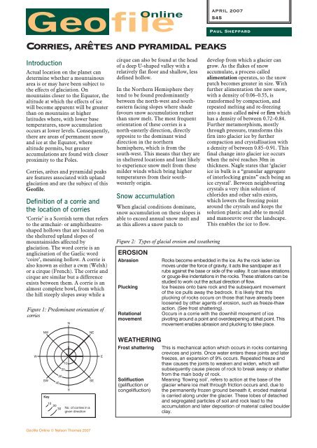
GeofileOnlineIntroductionActual location on the planet c<strong>and</strong>etermine whether a mountainousarea is or may have been subject tothe effects of glaciation. Onmountains closer to the Equator, thealtitude at which the effects of icewill become apparent will be greaterthan on mountains at higherlatitudes where, with lower basetemperatures, snow accumulationoccurs at lower levels. Consequently,there are areas of permanent snow<strong>and</strong> ice at the Equator, wherealtitude permits, but greateraccumulations are found with closerproximity to the Poles.Corries, arêtes <strong>and</strong> <strong>py</strong>ramidal peaksare features associated with upl<strong>and</strong>glaciation <strong>and</strong> are the subject of thisGeofile.Definition of a corrie <strong>and</strong>the location of corries‘Corrie’ is a Scottish term that refersto the armchair- or amphitheatreshapedhollows that are located onthe sheltered upl<strong>and</strong> slopes ofmountainsides affected byglaciation. The word corrie is ananglicisation of the Gaelic word‘coire’, meaning hollow. A corrie isalso known as either a cwm (Welsh)or a cirque (French). The corrie <strong>and</strong>cirque are similar but a differenceexists between them. A corrie is analmost complete bowl, from whichthe hill steeply slopes away while acirque can also be found at the headof a deep U-shaped valley with arelatively flat floor <strong>and</strong> shallow, lessdefined hollow.In the <strong>No</strong>rthern Hemisphere theytend to be found predominantlybetween the north-west <strong>and</strong> southeasternfacing slopes where shadefavours snow accumulation ratherthan snow melt. The most frequentorientation of these corries is anorth-easterly direction, directlyopposite to the dominant winddirection in the northernhemisphere, which is from thesouth-west. This means that they arein sheltered locations <strong>and</strong> least likelyto experience snow melt from thesemilder winds which bring highertemperatures from their southwesterlyorigin.Snow accumulationWhen glacial conditions dominate,snow accumulation on these slopes isable to exceed annual snow melt <strong>and</strong>as this allows a snow patch toAPRIL 2007545Corries, arêtes <strong>and</strong> <strong>py</strong>ramidal peaksFigure 1: Predominant orientation ofcorriesNFigure 2: Types of glacial erosion <strong>and</strong> weatheringEROSIONAbrasionPluckingRotationalmovementPaul Shepparddevelop from which a glacier cangrow. As the flakes of snowaccumulate, a process calledalimentation operates, so the snowpatch becomes greater in size. Withfurther alimentation the new snow,with a density of 0.06–0.55, istransformed by compaction, <strong>and</strong>repeated melting <strong>and</strong> re-freezinginto a mass called névé or firn whichhas a density of between 0.72–0.84.Further metamorphism, mostlythrough pressure, transforms thisfirn into glacier ice by furthercompaction <strong>and</strong> crystallisation witha density of between 0.85–0.91. Thisfinal change into glacier ice occurswhen the névé reaches 30m inthickness. Nagle states that ‘glacierice in bulk is a “granular aggregateof interlocking grains” each being anice crystal’. Between neighbouringcrystals a very thin solution ofchlorides <strong>and</strong> other salts exists,which lowers the freezing pointaround the crystals <strong>and</strong> keeps thesolution plastic <strong>and</strong> able to mould<strong>and</strong> manoeuvre over the l<strong>and</strong>scape.This enables the ice to flow.Rocks become embedded in the ice. As the rock laden icemoves under the force of gravity, it acts like s<strong>and</strong>paper as itrubs against the base or side of the valley. It can leave striationsor gouge-like indentations in the rocks. These striations can bestudied to work out the actual direction of flow.Ice freezes onto bare rock <strong>and</strong> the subsequent movementof the ice pulls away the bedrock. It is likely that thisplucking of rocks occurs on those that have already beenloosened by other agents of erosion, such as freeze-thawaction. (See frost shattering).Occurs in a corrie with the downhill movement of icepivoting around a point <strong>and</strong> overdeepening at that point. Thismovement enables abrasion <strong>and</strong> plucking to take place.WNWSWKey10403020302010S<strong>No</strong>. of corries in agiven directionNESEEWEATHERINGFrost shattering This is mechanical action which occurs in rocks containingcrevices <strong>and</strong> joints. Once water enters these joints <strong>and</strong> laterfreezes, an expansion of 9% occurs. Repeated freeze <strong>and</strong>thaw causes the joints to weaken <strong>and</strong> widen, which willsubsequently cause pieces of rock to break away or shatterfrom the main body of rock.Solifluction Meaning ‘flowing soil’, refers to action at the base of the(gelifluction orcongelifluction)glacier where ice melt through friction occurs <strong>and</strong>, due tothe permanently frozen ground beneath it, eroded materialis carried along under the glacier. These lobes of detached<strong>and</strong> segregated particles of soil <strong>and</strong> rock lead to theaccumulation <strong>and</strong> later deposition of material called boulderclay.Geofile Online © Nelson Thornes 2007GeoFile Series 25 Issue 3
April 2007 no.545 Corries, arêtes <strong>and</strong> <strong>py</strong>ramidal peaksLocation determines the speed ofthis transformation into ice whichcan take up to 200 years in dryenvironments such as Greenl<strong>and</strong>where snowfall may only be 10mmper annum, to a shorter time framein warmer <strong>and</strong> moister climaticzones.Figure 3: Erosional activity in a corrieBergschrund – allows meltwater <strong>and</strong>material weathered by freeze-thaw toenter body of iceCrevasses (olderbergschrunds)Pivot of rotationTogether with the unique terrain onwhich each individual snow patch isfound, the snow patch graduallyetches itself into the hillside by aprocess called nivation, wherebyfreeze-thaw action, solifluction <strong>and</strong>rotational movement erode back intothe hollow, creating a steepheadwall.ExtendingflowRotationalmovementCrevasses dueto bendingof iceFor a glacier to develop, a prolongedperiod of ice accumulation is needed.This extends into thous<strong>and</strong>s ofyears. Any shorter period would notallow sufficient accumulation of iceto occur or for the ice, which flowsunder gravity, to be replaced at itssource <strong>and</strong> enable a glacier to flow.Geologists <strong>and</strong> geomorphologistsstudying mountainous areascontaining corries, arêtes <strong>and</strong><strong>py</strong>ramidal peaks believe that thesefeatures are not the result of oneglacial period but a whole series ofglacial activities. In the British Isles<strong>and</strong> <strong>No</strong>rthern Europe, over 40 iceadvances have been identified; themost recent glaciation covering<strong>No</strong>rthern Britain <strong>and</strong> <strong>No</strong>rthernEurope ended only 10,000 years ago.The formation of a corrieA corrie develops on the highermountain slopes where snowaccumulates, compacts, becomes ice<strong>and</strong> then moves under gravity <strong>and</strong> isreplaced by new snow <strong>and</strong> later iceensuring a continuous glacial flow(Figure 3). The former pre-glacialhollow is enlarged <strong>and</strong> deepened asa result of nivation. Once the iceaccumulated in the glacier hasachieved an optimum weight <strong>and</strong>depth <strong>and</strong> it begins to flowdownhill, rotational movement willenable plucking <strong>and</strong> abrasion to acton the base of the hollow. Thisaction will cause the deepening ofthe hollow. Material eroded by theice will be transported by the iceeither within its bulk or bymeltwater caused by frictionbetween the solid rock <strong>and</strong> the iceitself. This will allow the flow ofsome material acting as a protectivelayer <strong>and</strong> allow further deepening ofthe corrie to take place.Rate of deepeningdepends upon theresistance of bedrockThe surface of the glacier will bemarked with bergschrunds, orcrevasses, which allow meltwater<strong>and</strong> rock debris, the result of freezethaw on the exposed mountainsides,to enter the mass of ice. Thebergschrund forms wherecompacted firn pulls away from theice frozen to the rock of theheadwall, leading to headwarderosion <strong>and</strong> the subsequent erosion<strong>and</strong> retreat of the mountainside.Similarly, the meltwater aids theprocess of freeze-thaw, while thedebris may be carried in the mass ofthe ice or make its way to the base ofthe glacier where it can act as anabrasive tool.Most of this deepening occurs onthe back wall <strong>and</strong> the rear of thehollow where the gradient is steeper.Where the glacier levels out <strong>and</strong> thegradient is less, the erosive powersof the glacier diminish <strong>and</strong>deepening of the hollow becomesless. This leads to the developmentof a small lip over which the ice willflow before following the formerriver course or earlier glacial coursedown its valley.These processes are happeningtoday in glacial regions such asSweden where the Kebnekaisecirque glacier occupies a hollow <strong>and</strong>is acting in the manner that hasbeen described. Other areas of theworld display corries after the icehas disappeared <strong>and</strong>geomorphologists <strong>and</strong> geologistsneed to be able to study both stagesof development to underst<strong>and</strong> theintricacies involved in corrieformation.GeoFile Series 25 Issue 3Fig 545_03 Mac/eps/illustrator 11 s/sNELSON THORNES PUBLISHINGArtist: David Russell IllustrationlipCompressiveflowFlow toU-shapedvalleyThe corries in the ScottishCairngorms have been closely studied<strong>and</strong> their formation in the Quaternaryperiod, which in geological termsrelates to the last two million years,suggests that they were a feature oflocalised mountain glaciation. Manyhollows were wholly or partly filledbut their flow away from their sourceenabled larger valley glaciers to form.The corries display signs of multipleglaciation. The glacial deposits ormoraines found in examples of corriessuch as Coire an t-Sneacdha are smallcompared to the size of the corrie <strong>and</strong>indicate that transportation by the ice<strong>and</strong> post glacial ice melt haveremoved much of this material. Forin-depth case study of Coire an t-Sneachda visit www.fettes.co./cairngorms/coire%20Sneachda.Studies in the Cairngorms have foundthat 70 to 90% of corries\wereorientated between north <strong>and</strong> east,matching similar studies relating tocorrie orientation. It was alsosuggested that the current size of thecorries investigated was reached aboutone million years ago <strong>and</strong> with theonset of later glaciations the valleyglaciers were over-ridden by ice sheetswhich covered the whole area.Evidence suggested for this is theremoval of pinnacles of rock <strong>and</strong>ridges associated with the back wall ofa corrie such as that as seen at Fiacailla’Choire Chais.Geofile Online © Nelson Thornes 2007
April 2007 no.545 Corries, arêtes <strong>and</strong> <strong>py</strong>ramidal peaksFigure 4: Extent of ice cover in Europe in the Quaternary Ice AgeLake <strong>District</strong>SnowdoniaThe Thames–Severn lineCairngormsIcel<strong>and</strong>which separated one river systemfrom another in pre-glacial times.The best examples of arêtes in theUnited Kingdom are Crib Goch inSnowdonia (Grid Reference 605545,O.S. Sheet 115) <strong>and</strong> Striding Edge onHelvellyn in the English Lake<strong>District</strong> (Figure 5). At Striding Edge(Grid Reference 345149, OS Sheet 90)the serrated ridge is only a footpathwidth in places <strong>and</strong> as furtherheadward erosion occurs the ridgeitself will theoretically become lower<strong>and</strong> wider in time. One of the twocorries making up the arête contains atypical corrie lake otherwise known asa tarn. This is Red Tarn (GridReference 348153, O.S. sheet 90)which occupies the over-deepenedhollow created by the ice.PyreneesAs can be seen from Figure 4,glaciation in the British Islesextended northwards of a line roughlystretching west-east from the Severnestuary to just north of the Thamesestuary. The mountainous areascontained north of this line includeSnowdonia, the English Lake <strong>District</strong><strong>and</strong> the Scottish Cairngorms.Evidence of mountain glaciation <strong>and</strong>subsequent corrie development isevident in all three of these regions.Alpserosion <strong>and</strong> over-deepeningassociated with such activity will leadto the formation of a ridge betweenthe two headwalls of the corries. Thissharp serrated ridge is called an arête<strong>and</strong> marks the remains of the formerinterfluve, or broad upl<strong>and</strong> ridge,GeoFile Series 25 Issue 3Fig 545_04 Mac/eps/illustrator 11 s/sNELSON THORNES PUBLISHINGArtist: David Russell IllustrationKeyIce sheetsPyramidal peaksA <strong>py</strong>ramidal peak is formed whenthree or more glaciers radiateoutwards from one mountain <strong>and</strong> theheadward erosion <strong>and</strong> all the erosiveactivities associated with corrieformation are replicated on each sideof the mountain. This leads to theclassic <strong>py</strong>ramid shape with a sharppeak. The classic <strong>py</strong>ramidal peak isthe Matterhorn, in the Swiss Alps.Figure 5: Striding Edge, an example of an arête <strong>and</strong> a corrie lakeWhen studying an Ordnance Surveymap extract of such an area adistinctive pattern of contour linesindicates the presence of a corrie. Aclose pattern of contour lines in analmost crescent shape indicates thesteep back wall of the corrie <strong>and</strong> anarea lacking in contours indicates thehollow where over-deepeningoccurred. This is often filled with alake or tarn, the alternative name forthe corrie lake. The ‘front’ of thecorrie is marked by a further contourwhere the l<strong>and</strong> rises (the lip),indicating where erosion was less <strong>and</strong>behind which the lake can accumulatein post-glacial times.ArêtesIf an upl<strong>and</strong> area supported two rivervalleys flowing in different directionsin pre-glacial times, the onset ofglaciation may lead to thedevelopment of two glaciers. If this isthe case, the actions associated withthe formation of a corrie will beoccurring in more than one locationat the same time. The headwardFigure 6: World Examples of Pyramidal PeaksNameMount AssiniboineInnerdalstarnetShivlingAma DablanCnicht *Location of ‘Pyramidal Peak’‘Matterhorn’ of the Rockies‘Matterhorn’ of <strong>No</strong>rway‘Matterhorn’ of India‘Matterhorn’ of the Himalayas‘Matterhorn’ of Wales* Perhaps the least convincing example due to its low elevation (2265ft/697m)<strong>and</strong> lack of steepness <strong>and</strong> classic <strong>py</strong>ramid shape.Geofile Online © Nelson Thornes 2007
April 2007 no.545 Corries, arêtes <strong>and</strong> <strong>py</strong>ramidal peaksFigure 7: OS location of Cnicht Peak, Snowdonia (sheet 124)Reproduced by permission of Ordnance Survey on behalf of HMSO © Crown co<strong>py</strong>right 2007. All rights reserved. Ordnance SurveyLicence number 10017284.<strong>No</strong> definitive examples of <strong>py</strong>ramidalpeaks exist in the United Kingdom<strong>and</strong> only four other true <strong>py</strong>ramidalpeaks have been identified aroundthe world (Figure 6) .The United Kingdom, with itscurrent post-glacial environment,displays in its mountainous regionsexamples of glacial erosion. Corriesin particular are commonplace inSnowdonia, the English Lake<strong>District</strong> <strong>and</strong> all of the upl<strong>and</strong> areasfound in Scotl<strong>and</strong>, while arêtes areless common <strong>and</strong> <strong>py</strong>ramidal peaksare a rarity, even on a world scale.The mostly resistant igneousmaterials, which dominate theseareas of the United Kingdom wereformed at the plate boundarybetween the Atlantic <strong>and</strong> Europeanplates <strong>and</strong> has been affected bymultiple glaciations. The currentsupposed inter-glacial period hasenabled these features to becomevisible <strong>and</strong> geographers have beenable to interpret how ice acts upon al<strong>and</strong>scape in upl<strong>and</strong> environments<strong>and</strong> the features produced by suchglacial activity.Further informationOrdnance Survey 1:50,000 mapsheet 115 (Snowdonia)Ordnance Survey 1:25,000 ExplorerMap OL 7 (the English LakesSouth-eastern area)D. Waugh, Geography, An IntegratedApproach, Nelson.J.G.Wilson, L<strong>and</strong>scape <strong>and</strong>Atmosphere,Schofield & Sims.G. Nagle, Advanced Geography, OUP.K. Hilton, Process <strong>and</strong> Pattern inPhysical Geography, Unwin Hyman.FocusQuestions1. How do the different agents of erosion associated with glaciation actin the formation of corries, arêtes <strong>and</strong> <strong>py</strong>ramidal peaks?2. Either:a). Using the O.S.map of The English Lake <strong>District</strong>, locate Hellvellyn <strong>and</strong>Striding Edge.Make a sketch map of this area <strong>and</strong> label on your sketch map the arête, RedTarn, a second corrie <strong>and</strong> indicate the direction of ice flow <strong>and</strong> thedirection the two corries face.Or,b). Using an O.S. map of an area of glaciation in the UK you have access to,locate <strong>and</strong> identify examples of corries <strong>and</strong> arêtes <strong>and</strong> make a sketch mapindicating the features <strong>and</strong> adding arrows to indicate the direction of iceflow <strong>and</strong> the direction the features identified face.3. Explain why arêtes are less common than corries <strong>and</strong> <strong>py</strong>ramidal peaksless common than arêtes.Geofile Online © Nelson Thornes 2007