Salmon Spawning Ground Surveys, 1989-92 Project F-73-R-15
Salmon Spawning Ground Surveys, 1989-92 Project F-73-R-15
Salmon Spawning Ground Surveys, 1989-92 Project F-73-R-15

You also want an ePaper? Increase the reach of your titles
YUMPU automatically turns print PDFs into web optimized ePapers that Google loves.
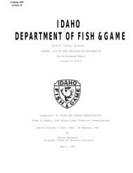
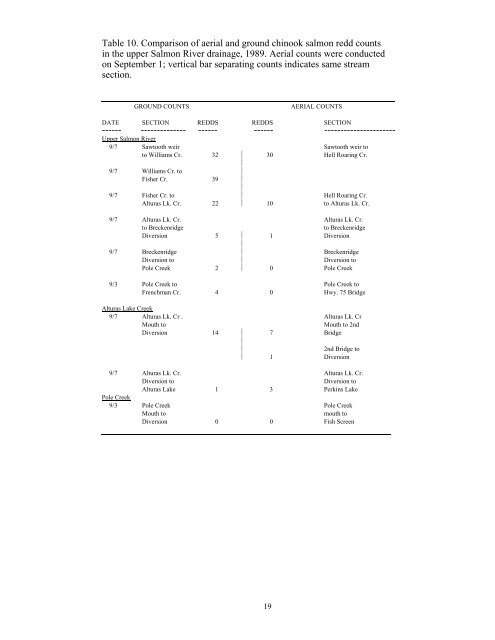
Table 10. Comparison of aerial and ground chinook salmon redd counts<br />
in the upper <strong>Salmon</strong> River drainage, <strong>1989</strong>. Aerial counts were conducted<br />
on September 1; vertical bar separating counts indicates same stream<br />
section.<br />
GROUND COUNTS<br />
AERIAL COUNTS<br />
DATE SECTION REDDS REDDS SECTION<br />
------ -------------- ------ ------ ----------------------<br />
Upper <strong>Salmon</strong> River<br />
9/7 Sawtooth weir Sawtooth weir to<br />
to Williams Cr. 32 ⏐ 30 Hell Roaring Cr.<br />
⏐<br />
9/7 Williams Cr. to ⏐<br />
Fisher Cr. 39 ⏐<br />
⏐<br />
9/7 Fisher Cr. to ⏐ Hell Roaring Cr.<br />
Alturas Lk. Cr. 22 ⏐ 10 to Alturas Lk. Cr.<br />
9/7 Alturas Lk. Cr. Alturas Lk. Cr.<br />
to Breckenridge<br />
to Breckenridge<br />
Diversion 5 ⏐ 1 Diversion<br />
⏐<br />
9/7 Breckenridge ⏐ Breckenridge<br />
Diversion to ⏐ Diversion to<br />
Pole Creek 2 ⏐ 0 Pole Creek<br />
9/3 Pole Creek to Pole Creek to<br />
Frenchman Cr. 4 0 Hwy. 75 Bridge<br />
Alturas Lake Creek<br />
9/7 Alturas Lk. Cr . Alturas Lk. Cr<br />
Mouth to<br />
Mouth to 2nd<br />
Diversion 14 ⏐ 7 Bridge<br />
⏐<br />
⏐<br />
2nd Bridge to<br />
⏐ 1 Diversion<br />
9/7 Alturas Lk. Cr. Alturas Lk. Cr.<br />
Diversion to<br />
Diversion to<br />
Alturas Lake 1 3 Perkins Lake<br />
Pole Creek<br />
9/3 Pole Creek Pole Creek<br />
Mouth to<br />
mouth to<br />
Diversion 0 0 Fish Screen<br />
19