Salmon Spawning Ground Surveys, 1989-92 Project F-73-R-15
Salmon Spawning Ground Surveys, 1989-92 Project F-73-R-15
Salmon Spawning Ground Surveys, 1989-92 Project F-73-R-15
Create successful ePaper yourself
Turn your PDF publications into a flip-book with our unique Google optimized e-Paper software.
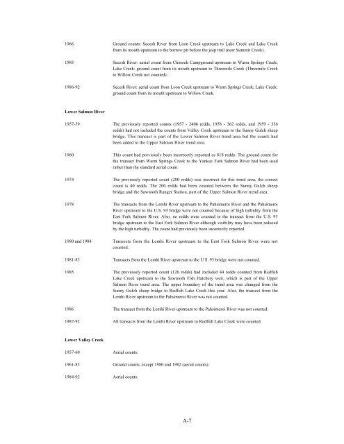
1966 <strong>Ground</strong> counts: Secesh River from Loon Creek upstream to Lake Creek and Lake Creek<br />
from its mouth upstream to the borrow pit before the jeep trail (near Summit Creek).<br />
1985 Secesh River: aerial count from Chinook Campground upstream to Warm Springs Creek;<br />
Lake Creek: ground count from its mouth upstream to Threemile Creek (Threemile Creek<br />
to Willow Creek not counted).<br />
1986-<strong>92</strong> Secesh River: aerial count from Loon Creek upstream to Warm Springs Creek; Lake Creek:<br />
ground count from its mouth upstream to Willow Creek.<br />
Lower <strong>Salmon</strong> River<br />
1957-59 The previously reported counts (1957 - 2406 redds, 1958 - 362 redds, and 1959 - 336<br />
redds) had not included the counts from Valley Creek upstream to the Sunny Gulch sheep<br />
bridge. This transact is part of the Lower <strong>Salmon</strong> River trend area but the counts had<br />
been added to the Upper <strong>Salmon</strong> River trend area.<br />
1960 This count had previously been incorrectly reported as 818 redds. The ground count for<br />
the transact from Warm Springs Creek to the Yankee Fork <strong>Salmon</strong> River had been used<br />
rather than the standard aerial count.<br />
1974 The previously reported count (200 redds) was incorrect for this trend area, the correct<br />
count is 40 redds. The 200 redds had been counted between the Sunny Gulch sheep<br />
bridge and the Sawtooth Ranger Station, part of the Upper <strong>Salmon</strong> River trend area.<br />
1978 The transacts from the Lemhi River upstream to the Pahsimeroi River and the Pahsimeroi<br />
River upstream to the U.S. 93 bridge were not counted because of high turbidity from the<br />
East Fork <strong>Salmon</strong> River. Also, no redds were counted in the transact from the U.S. 93<br />
bridge upstream to the East Fork <strong>Salmon</strong> River although visibility may have been reduced<br />
by the high turbidity. The count had previously been incorrectly reported.<br />
1980 and 1984 Transects from the Lemhi River upstream to the East Fork <strong>Salmon</strong> River were not<br />
counted.<br />
1981-83 Transacts from the Lemhi River upstream to the U.S. 93 bridge were not counted.<br />
1985 The previously reported count (126 redds) had included 44 redds counted from Redfish<br />
Lake Creek upstream to the Sawtooth Fish Hatchery weir, which is part of the Upper<br />
<strong>Salmon</strong> River trend area. The upper boundary of the trend area was changed from the<br />
Sunny Gulch sheep bridge to Redfish Lake Creek this year. Also, the transect from the<br />
Lemhi River upstream to the Pahsimeroi River was not counted.<br />
1986 The transact from the Lemhi River upstream to the Pahsimeroi River was not counted.<br />
1987-<strong>92</strong> All transacts from the Lemhi River upstream to Redfish Lake Creek were counted.<br />
Lower Valley Creek<br />
1957-60 Aerial counts.<br />
1961-83 <strong>Ground</strong> counts, except 1980 and 1982 (aerial counts).<br />
1984-<strong>92</strong> Aerial counts.<br />
A-7


