Salmon Spawning Ground Surveys, 1989-92 Project F-73-R-15
Salmon Spawning Ground Surveys, 1989-92 Project F-73-R-15
Salmon Spawning Ground Surveys, 1989-92 Project F-73-R-15
Create successful ePaper yourself
Turn your PDF publications into a flip-book with our unique Google optimized e-Paper software.
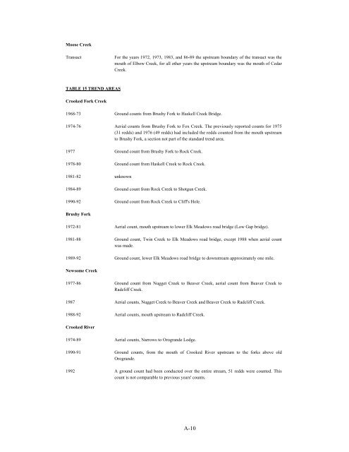
Moose Creek<br />
Transact<br />
For the years 1972, 19<strong>73</strong>, 1983, and 86-89 the upstream boundary of the transact was the<br />
mouth of Elbow Creek, for all other years the upstream boundary was the mouth of Cedar<br />
Creek.<br />
TABLE <strong>15</strong> TREND AREAS<br />
Crooked Fork Creek<br />
1968-<strong>73</strong> <strong>Ground</strong> counts from Brushy Fork to Haskell Creek Bridge.<br />
1974-76 Aerial counts from Brushy Fork to Fox Creek. The previously reported counts for 1975<br />
(31 redds) and 1976 (49 redds) had included the redds counted from the mouth upstream<br />
to Brushy Fork, a section not part of the standard trend area.<br />
1977 <strong>Ground</strong> count from Brushy Fork to Rock Creek.<br />
1978-80 <strong>Ground</strong> count from Haskell Creek to Rock Creek.<br />
1981-82 unknown<br />
1984-89 <strong>Ground</strong> count from Rock Creek to Shotgun Creek.<br />
1990-<strong>92</strong> <strong>Ground</strong> count from Rock Creek to Cliff's Hole.<br />
Brushy Fork<br />
1972-81 Aerial count, mouth upstream to lower Elk Meadows road bridge (Low Gap bridge).<br />
1981-88 <strong>Ground</strong> count, Twin Creek to Elk Meadows road bridge, except 1988 when aerial count<br />
was made.<br />
<strong>1989</strong>-<strong>92</strong> <strong>Ground</strong> count, lower Elk Meadows road bridge to downstream approximately one mile.<br />
Newsome Creek<br />
1977-86 <strong>Ground</strong> count from Nugget Creek to Beaver Creek, aerial count from Beaver Creek to<br />
Radcliff Creek.<br />
1987 Aerial counts, Nugget Creek to Beaver Creek and Beaver Creek to Radcliff Creek.<br />
1988-<strong>92</strong> Aerial counts, mouth upstream to Radcliff Creek.<br />
Crooked River<br />
1974-89 Aerial counts, Narrows to Orogrande Lodge.<br />
1990-91 <strong>Ground</strong> counts, from the mouth of Crooked River upstream to the forks above old<br />
Orogrande.<br />
19<strong>92</strong> A ground count had been conducted over the entire stream, 51 redds were counted. This<br />
count is not comparable to previous years' counts.<br />
A-10


