uganda protectorate - Palgrave Connect
uganda protectorate - Palgrave Connect
uganda protectorate - Palgrave Connect

You also want an ePaper? Increase the reach of your titles
YUMPU automatically turns print PDFs into web optimized ePapers that Google loves.
10.1057/9780230270305 - The Statesman's Year-Book, Edited by John Scott-Keltie<br />
GOVERNMENT—JUSTICE 197<br />
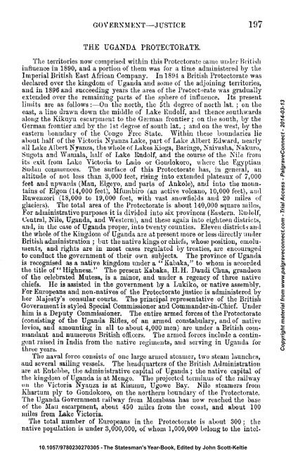
THE UGANDA PROTECTORATE.<br />
The territories now comprised within this Protectorate came under British<br />
influence in 1890, and a portion of them was for a time administered by the<br />
Imperial British East African Company. In 1894 a British Protectorate was<br />
declared over the kingdom of Uganda and some of the adjoining territories,<br />
and in 1896 and succeeding years the area of the Protectorate was gradually<br />
extended over the remaining parts of the sphere of influence. Its present<br />
limits are as follows:—On the north, the 5th degree of north lat. ; on the<br />
east, a line drawn down the middle of Lake Rudolf, and thence southwards<br />
along the Kiknyu escarpment to the German frontier ; on the south, by the<br />
German frontier and by the 1st degree of south lat. ; and on the west, by the<br />
eastern boundary of the Congo Free State. Within these boundaries lie<br />
about half of the Victoria Nyanza Lake, part of Lake Albert Edward, nearly<br />
all Lake Albert Nyanza, the whole of Lakes Kioga, Baringo, Naivasha, 'Nakuro,<br />
Sugota and Wamala, half of Lake Rudolf, and the course of the Nile from<br />
its exit from Lake Victoria to Lado or Gondokoro, where the Egyptian<br />
tSudan commences. The surface of this Protectorate has, in genera], an<br />
altitude of not less than 3,000 feet, rising into extended plateaux of 7,000<br />
feet and upwards (Mau, Elgeyo, and parts of Ankole), and into the mountains<br />
of Elgon (14,000 feet), Mfumbiro (an active volcano, 10,000 feet), and<br />
Ruweuzori (18,000 to 19,000 feet, with vast snovvfields and 20 miles of<br />
glaciers). The total area of the Protectorate is about 140,000 square miles,<br />
For administrative purposes it is divided into six provinces (Eastern. Rudolf,<br />
Central, Nile, Uganda, and Western), and these again into eighteen districts,<br />
and, in the case of Uganda proper, into twenty counties. Eleven districts and<br />
the whole of the Kingdom of Uganda are at present more or less directly under<br />
British administration ; but the native kings or chiefs, whose position, emoluments,<br />
and rights are in most cases regulated by treaties, are encouraged<br />
to conduct the government of their own subjects. The province of Uganda<br />
is recognised as a native kingdom under a " Kabaka," to whom is accorded<br />
the title of" Highness." The present Kabaka, H.H. Daudi Chua, grandson<br />
of the celebrated Mutesa, is a minor, and under a regency of three native<br />
chiefs. He is assisted in the government by a Lukiko, or native assembly.<br />
For Europeans and non-natives of the Protectorate justice is administered by<br />
her Majesty's consular courts. The principal representative of the British<br />
Government is styled Special Commissioner and Commander-in-Chief. Under<br />
him is a Deputy Commissioner. The entire armed forces of the Protectorate<br />
(consisting of the Uganda Rifles, of an armed constabulary, and of native<br />
levies, and amounting in all to about 4,000 men) are under a British commandant<br />
and numerous British officers. The armed forces include a contingent<br />
raised in India from the native regiments, and serving in Uganda for<br />
three years.<br />
The naval force consists of one large armed steamer, two steam launches,<br />
and several sailing vessels. The headquarters of the British Administration<br />
are at Entebbe, the administrative capital of Uganda ; the native capital of<br />
the kingdom of Uganda is at Mengo. The projected terminus of the railway<br />
on the Victoria Nyanza is at Kisumu, Ugowe Bay. Nile steamers from<br />
Khartum ply to Gondokoro, on the northern boundary of the Protectorate.<br />
The Uganda Government railway from Mombasa has now reached the base<br />
of the Mau escarpment, about 450 miles from the coast, and about 100<br />
miles from Lake Victoria.<br />
The total number of Europeans in the Protectorate is about 300 ; the<br />
native population is under 3,000,000, of whom 1,000,000 belong to the intel-<br />
Copyright material from www.palgraveconnect.com - Trial Access - <strong>Palgrave</strong><strong>Connect</strong> - 2014-03-13
10.1057/9780230270305 - The Statesman's Year-Book, Edited by John Scott-Keltie<br />
198 THE BRITISH KMJ'iliK :—KAST AFRICA<br />
ligcnt, civilised Bagauda, a race converted to Christianity by British and<br />
French missionaries. About 1,700,000 natives speak Bantu languages ;<br />
there are a few pygmies or Congo dwarfs living near the Semliki river ; the<br />
rest of the natives belong to the Masai, Nilotic, and Sudanese groups. The<br />
fauna and flora are the richest in Africa, and are divided in their affinities<br />
between East and West Africa. The soil is very fertile,'except in the<br />
Rudolf region. Iron is found everywhere, copper in the Central province,<br />
gold in a few places. The chief commercial products are ivory, timber,<br />
rubber, and cattle. Trade is in the hands of two German firms and one<br />
British; and is also carried on to an increasing extent by British Indians,<br />
Persians, and Arabs. The local revenue for 1900-01 is estimated at<br />
40,0007. It is raised in part by the native hut and gun taxes.<br />
{special Commissioner and Commander-in-Chief.—Sir Harry H. Johnston,<br />
K.C.B.<br />
Deputy Commissioner.—-¥. J. Jackson, C.B.<br />
ZANZIBAR PROTECTORATE<br />
Sultan and Government.<br />
The Sultan, or more correctly, the Seyyid, Hamoud bin Mahomed bin<br />
Sai'd, about 44 years of age, nephew of the late Sultans Ali, Khalifa and<br />
Burghash, succeeded to the Sultanate on the death of Seyyid Hamed bin<br />
Thwain on August 27, 1896. He was one of two claimants, and was<br />
selected by the British Government as being the most fitting.<br />
Zanzibar dominions were gradually acquired by the Imams of Muscat at<br />
various dates between the years 1698 and 1807, partly by conquest from the<br />
Portuguese and partly from native chiefs. They were held as an appanage of<br />
Muscat until the death of Seyyid Said, when, on a dispute as to the succession<br />
arising between Seyyid Thwain, of Muscat, uncle of the present Sultan of Zanzibar,<br />
and Seyyid Majid, of Zanzibar (both being sons of Seyyid Said), the dominions<br />
in Africa were made independent of the present State, and confirmed under<br />
Majid by an arbitration of Lord Canning (dated 1861), then Governor-General<br />
of India. Besides the islands of Zanzibar, Pemba, and smaller islands, the<br />
Sultan's authority nominally extended along the coasts and indefinitely inland,<br />
from Warsheikh, in 3° N. lat., to Tunghi Bay, in 10° 42' S. lat., his influence,<br />
however, being exercised but a little way from the coast, except along<br />
a few trade routes. As mentioned above, the Sultan's dominions were<br />
gradually restricted in area between the years 1886 and 1890, until they<br />
finally included only the islands of Zanzibar and Pemba.<br />
In October 1891, a regular Government was formed for Zanzibar, of which<br />
Sir L. Mathews is Prime Minister. All accounts are now kept in English<br />
and Arabic, and are always open to the inspection of the British Agent and<br />
Consul-General, and no new undertakings or additional expenditure can be<br />
incurred without his consent. On February 1, 1892, Zanzibar was declared a<br />
free port, and it remained so until October 1, 1899, when a 5 per cent, ad<br />
valorem duty was imposed on all imports.<br />
Area, Population, Religion,<br />
The island of Zanzibar has an area of 640 square miles, and Pemba 380<br />
square miles. The population of the island is estimated at 150,000, and that<br />
of the island of Pemba at 50,000. There is a considerable foreign population,<br />
mostly engaged in trading. There are about 50 Englishmen, 50 Germans,<br />
a few Americans, Frenchmen, Italians, Greeks, and Roumanians, the two<br />
latter nationalities being under British protection. There are also about 7,000<br />
British Indian subjects, through whose hands almost the whole trade of<br />
Copyright material from www.palgraveconnect.com - Trial Access - <strong>Palgrave</strong><strong>Connect</strong> - 2014-03-13
10.1057/9780230270305 - The Statesman's Year-Book, Edited by John Scott-Keltie<br />
JUSTICE—FINANCE AND COMMENCE 199<br />
Zanzibar and of East Africa passes, directly or indirectly. The town of<br />
Zanzibar has a population estimated at 30,000.<br />
Mohammedanism is the religion of the country, most of the natives of the<br />
coast and islands being Sunnis of the Shaft school, though many are heathen ;<br />
while the Sultan ami his relatives are schismatics of the Ibadhi sect.<br />
There are Christian missions (Church of England, Wesleyan, Independent,<br />
and Roman Catholic) on the island anil far into the mainland.<br />
There is a French hospital at Zanzibar, attended by French sisters of<br />
mercy, and a hospital at the Universities Mission. Sir Tharia Topan's<br />
hospital for Indians is completed, but is not yet in use.<br />
Justice.<br />
Justice among the Sultan's subjects, whether accused or defendants, is<br />
administered by various 'Cadis.' By a declaration signed December 16,<br />
1892, the Sultan delegated to the British Agent and Consul-General his<br />
right to try all cases in which a British subject is plaintiff or accuser, and the<br />
defendant or accused is a Zanzibar subject or the subject of a non-Christian<br />
state without a treaty. The British Court has also jurisdiction over all slaves<br />
originally freed by her Majesty's Agent and Consul-General, but as the legal<br />
status of slavery was abolished on the 6th April, 1897, the relations between<br />
master and slave are no longer recognised by the Tribunals. The judges of the<br />
British Court form an appeal court from the chief court of the East Africa<br />
Protectorate, and there is a further appeal from them to the Privy Council. To<br />
the British Court also pertains admiralty jurisdiction with reference to the<br />
slave trade, and it is a naval prize court, by virtue of the Zanzibar (Prize)<br />
Order in Council, 1888.<br />
There is a regular army of about 900 men, including police, under the<br />
command of General Kaikes.<br />
Finance and Commerce.<br />
The revenue of the Sultan was mainly derived from customs dues and taxes<br />
on produce, chiefly cloves. Under the new arrangement wt h England the<br />
Sultan's privy purse, which will be kept separate from the general revenue<br />
of the country, has been fixed at about 120,000 rupees annually, and the<br />
remainder of the revenue will be devoted to the charges for police, harbour<br />
improvements, and public works. All the public expenditure must receive<br />
the sanction of the Sultan and the British Agent and Consul-General.<br />
The value of imports and exports and the tonnage entered in recent<br />
years are stated as follows :—<br />
Years<br />
Imports<br />
Exports<br />
British<br />
Shipping entered<br />
Total<br />
Copyright material from www.palgraveconnect.com - Trial Access - <strong>Palgrave</strong><strong>Connect</strong> - 2014-03-13<br />
1897<br />
1898<br />
1899<br />
1,399,078<br />
1,555,070<br />
1,596,606<br />
1,189,668<br />
1,497,883<br />
1,513,407<br />
Tons<br />
75,013<br />
91,269<br />
103,457<br />
Tons<br />
245,368<br />
286,209<br />
324,961<br />
The figures include the trade between the port of Zanzibar and other ports<br />
in the Sultan's dominions. The chief imports and exports and distribution<br />
of trade were as follows in the last two years :—
10.1057/9780230270305 - The Statesman's Year-Book, Edited by John Scott-Keltie<br />
200 THE BRITISH EMPIRE :—EAST AFRICA<br />
__<br />
Imports<br />
(1S9S)<br />
Imports<br />
(189H)<br />
Exports<br />
(1698)<br />
Exports<br />
(1S99)<br />
Cloves . . . .<br />
Rice i .<br />
Piece goods<br />
Ivory . . . .<br />
Coal . . . .<br />
Copra, &c.<br />
Groceries . . . .<br />
Rubber . . . .<br />
From or to —<br />
United Kingdom<br />
British India .<br />
British East Africa .<br />
Germany . . . .<br />
German East Africa.<br />
France . . . .<br />
Belgium . . . .<br />
Zanzibar and Pemba<br />
America . . . .<br />
i 158~507<br />
i 197,160<br />
376,960<br />
113,164<br />
32,801<br />
59,315<br />
! 58,006<br />
: 30,853<br />
j<br />
121,211<br />
! 467,352<br />
59,544<br />
93,516<br />
214,100<br />
26,631<br />
—<br />
217,343<br />
78,991<br />
186,483<br />
193,497<br />
i 367,850<br />
113,204<br />
53,147<br />
30,596<br />
59,562<br />
40,517<br />
146,143<br />
491,548<br />
86,038<br />
95,833<br />
173,172<br />
24,178<br />
56,380<br />
240,658<br />
101,014<br />
143,730<br />
117,320<br />
361,875<br />
112,914<br />
—<br />
105,114<br />
—<br />
34,622<br />
114,716<br />
140,934<br />
202,581<br />
41,141<br />
476,680<br />
114,417<br />
—<br />
158,380<br />
57,092<br />
197,232<br />
141,631<br />
345,910<br />
127,312<br />
69,736<br />
—<br />
41,298<br />
116,964<br />
129 896<br />
190,641<br />
65,766<br />
457,238<br />
80,591<br />
2,724<br />
144,845<br />
84,464<br />
There is a special coinage issued under the Sultan's authority, of which<br />
the Maria Theresa dollar is the unit ; but the British Indian rupee is the<br />
coin now universally current, though in all business transactions the dollar<br />
is the standard of value. The dollar has a tixed value of 2 rupees 2 annas,<br />
and the rupee is worth 47 cents.<br />
British AgentandConsul-General.—Sir C. N. E. Eliot, K.C. M.G., C.B.<br />
Consul.—Basil Cave, C.B.<br />
Judge.—Walter B. Cracknall, C.M.G. Assistant Judge.—F. J. Collinson.<br />
Vice-Consuls.—V. K. Kestell-Cornish, D. MacLennan, J. H. Sinclair.<br />
Vice-Consul at Pemba.—D. R. O'Sullivan Beare.<br />
Vice-Consul at Dar es Salaam.—H. C. C. Dundas.<br />
Books of Reference concerning British East Africa.<br />
Correspondence and Farther Correspondence relating to Zanzibar. London, 188(5-90.<br />
Correspondence concerning the Abolition of the Legal Status of Slavery in Zanzibar and<br />
Pemba. London, 1897. Anti-Slavery Decree by Sultan of Zanzibar. Africa, No. 1 of<br />
1890-91. Reports on the Slave Trade of the East Coast of Africa (Africa, No. 7), 1887-88,<br />
and Africa, No. 6 of 1890-91. Papers relating to recent events in the Uganda Protectorate<br />
Africa, Nos. 1. and 4., 1899). London.<br />
Preliminary Report by H.M. Special Commissioner on the Protectorate of Uganda.<br />
London, 1900.<br />
Foreign Office Reports. Annual Series. London.<br />
Handbook of E. Africa. Intelligence Department, War Oliicc, 1S94.<br />
Hertslet's Treaties and the Map of Africa, by Treaty. 2nd ed., Vol. II. London, 1S97.<br />
Annual Statement of the Trade of the United Kingdom with Foreign Countries and<br />
British Possessions. London.<br />
Statistical Abstract for the Colonial and other Possessions of the United Kingdom,<br />
London.<br />
Ansorae (W- J.), Under the African Sun. [In Uganda.] London, 1899-<br />
Athe (Rev. R. P.), Two Kings of Uganda. 2nd ed. London, 1897.<br />
Baumann (Oscar), Durch Masailand zur Nilquelle. 8. Berlin, 1894. Die lnsel Sansibar.<br />
Published by the Verein fur Brdkunde. Leipzic, 1897.<br />
JWtte00(V.), ViaggidiScopertonelCuoredelT Africa. II Giuba Esplorato. Rome, 1895.<br />
Chanler (W. A.), Through Jungle and Desert. 8. Loudon. 1896.<br />
Copyright material from www.palgraveconnect.com - Trial Access - <strong>Palgrave</strong><strong>Connect</strong> - 2014-03-13
10.1057/9780230270305 - The Statesman's Year-Book, Edited by John Scott-Keltie<br />
MAURITIUS 201<br />
L'olville (Sir H.), The Laud of the Nile Springs. Loudon, 1895.<br />
Decle (L-), Three Years in Savage Africa. London, 1897.<br />
FitzQerald (W. W. A.), Travels in the Coastlands of British East Africa. London, 1898<br />
Gregory (J. W.), The Great Rift Valley. 8. London, 1896.<br />
Hohnel (Lieut, von), Discovery of Lakes Rudolf, &c. 2 vols. London, 1893<br />
Johnston (H. H.), Kilimanjaro. London, 1885.<br />
Johnston (Sir Harry), The Colonisation of Africa. Cambridge, 1899.<br />
Junker (W.), Travels in Africa, 1875-78. London, 1890. Travels in Africa, 1882-86.<br />
London, 1S92.<br />
Keltic (J. 8cott), The Partition of Africa. 2nd ed. London, 1895.<br />
Kallmann (P.), The Victoria Nyanza: the Land, the Races, and their Customs.<br />
London, 1900.<br />
Lugard (Capt. F. D.), The Rise of our East African Empire. 2 vols. London, 1893<br />
British East Africa and Uganda. London, 1892.—The Story of Uganda. London, 1900.<br />
McDermott (P. L.), British East Africa. London, 1895.<br />
MacDonald(J. R. L.), Soldiering and'Surveying in British East Africa. London, 1897.<br />
Meyer(Hans), Across East African Glaciers. [Translation contains Bibliography on this<br />
subject.] 8. London. 1891.<br />
Newman (H. S.), Banani: The Transition from Slavery to Freedom in Zanzibar and<br />
Pemba. London, 1898.<br />
Ortroz (F. Van), Conventions Internationales concernant 1'Afrique. Brussels, 1898.<br />
Peters (Dr.), New Light on Dark Africa. [Narrative of the German Emin Pasha Expedition.]<br />
8. London, 1891.<br />
Portal (Sir G.), Mission to Uganda. London, 1894.<br />
Purvis (J. B.), Handbook of British East Africa and Uganda. London, 1900.<br />
Reclus(E.), Geographic Universelle. Vol. XIII. Paris, 18SS (English edition, Vols.<br />
X. and XII.<br />
Scott-Elliott (G. F.), A Naturalist in Mid-Africa. London, 1896.<br />
Smith (A. Donaldson), Through Unknown African Countries. London, 1897.<br />
Stanley (H. M.), Through the Dark Continent. 2 vols. London. 1878.<br />
Strandes (J.), Die Portugiesenzeit von Deutsch-und Englisch Ost-Africa. Berlin,<br />
1899.<br />
Thomson (Joseph), To the Central African Lakes and Back. 2 vols. London, 1881.—<br />
Through Masai Laud. London, 1885.<br />
Thurston (A. B.), African Incidents. London, 1900.<br />
Yandeleur (C. F. S.), Two Years' Travel in Uganda, ifcc, and on the Upper Nile.<br />
Geographical Journal, Vol. IX. (April, 1897). London, 1897.<br />
Wickenburg (E. Graf), Wanderungcn in Ost-Afrika. [Somaiiland to Kilimanjaro.]<br />
Vienna, 1899.<br />
White (A. Silva), The Development of Africa. London, 1890.<br />
Wilson (Rev. C. T.) and Felkin (R. W.), Uganda and the Egyptian Soudan. 2 vols.<br />
London, 1882.<br />
Travels of Burton, Speke, Grant, Baker, and Junker.<br />
Gambia, Gold Coast, LagOS-<br />
See WEST AFIUCAN COLONIES.<br />
Mashonaland, Matabeleland. See RHODESIA.<br />
MAUEITIUS.<br />
Constitution and Government.<br />
The government of the British Colony of Mauritius, with its dependencies,<br />
Rodrigues, Diego Garcia, and the Seychelles Islands, is vested in a Governor,<br />
aided by an Executive Council, of which the officer in command of Her<br />
Majesty's troops, the Colonial Secretary, the l'rocureur-General, the Receiver-<br />
General, and the Auditor-General, and two elected members of the Council of<br />
Government are ex-officio members. There is also a Council of Government,<br />
consisting of the Governor and twenty-seven members, ten being elected, eight<br />
ex-officio, and nine nominated by the Governor. The official councillors<br />
comprise the five Executive members, the Collector of Customs, the Protector<br />
of Immigrants, and the Surveyor-General. The constitution was altered by<br />
letters patent dated September 16, 1885, which introduced an elective element<br />
into the Legislature. Under a moderate franchise ten members are now<br />
elected, one for each of the following districts:—Moka, Plaines Wilherns,<br />
Grand Port, Flacq, Savanne, Riviere Noire, Pamplemousses, Riviere du<br />
Rempart; and two for Port Louis.<br />
Copyright material from www.palgraveconnect.com - Trial Access - <strong>Palgrave</strong><strong>Connect</strong> - 2014-03-13
10.1057/9780230270305 - The Statesman's Year-Book, Edited by John Scott-Keltie<br />
202 THE BRITISH EMPIRE:—MAURITIUS<br />
Governor of Mam-Hues.—Sir Charles liruce, K.C.M.G. The Governor has<br />
a salary of 5,000., and the Colonial Secretary 13,500 rupees per annum.<br />
Area and Population.<br />
The island of Mauritius, lying in the Indian Ocean, 500 miles east of<br />
Madagascar, comprises an area of 705 English square miles. The following<br />
were the numbers of the population, according to the census taken in 1891 :—<br />
—<br />
Total of resident population<br />
Military in Port Louis and elsewhere .<br />
Crews of mercantile shipping<br />
Total of population<br />
Male<br />
■206, OSS<br />
721<br />
344<br />
207,103<br />
Female<br />
164,550<br />
2<br />
164,552<br />
Total<br />
370,588<br />
721<br />
346<br />
371,655<br />
The estimated population at the end of 1899 was :—General population,<br />
117,920; Indian, 261,739; total, 379,659. Two-thirds of the population<br />
consists of natives of African race, Chinese, mixed races, and whites. The<br />
number of Chinese was estimated at 3,079 on January 1, 1899. The birthrate<br />
of 1899 was 34'1 per 1,000, and death-rate 34 S. Immigrants in 1899,<br />
nil; departures, 746. The capital of the colony, Port Louis, had, with<br />
its suburbs, an estimated population of 52,517 in 1899.<br />
According to the census of 1891 there were 209,079 Hindoos, 115,438 Roman<br />
Catholics, 34,763 Mahometans, and 7,307 Protestants. State aid is granted to<br />
both Churches, the ecclesiastical expenditure by the State in 1899 having<br />
been 143,460 rupees ; the Indians are mostly Hindoos.<br />
A change is taking place in the population of Mauritius ; the greater part<br />
of Port Louis has in recent years passed from European to Indian or Chinese<br />
hands, and the sugar estates of the island are being similarly transferred.<br />
In 1899 land to the value of 1,268,320 rupees was purchased by Indians<br />
from French planters.<br />
Primary education is gratuitous but not compulsory. The government<br />
schools in 1899 had 9,777 pupils; the State-aided had 9,404 of whom 5,975<br />
were in Catholic schools. For secondary education provision is made by the<br />
Koyal College and its 2 schools with (1899) 420 pupils, and 24 associated<br />
schools (affiliated to the Royal College) with 450 pupils. At the Royal<br />
College many scholarships and exhibitions are awarded annually. The total<br />
government expenditure iu 1899 on education was 478,496 rupees, of which<br />
296,085 rupees was for primary education.<br />
The total number of convictions at the inferior courts in 1899 was 17,816,<br />
and at the Supreme Court, 24.<br />
Finance, Defence, Commerce.<br />
The revenue and expenditure of the colony for five years were : —<br />
-<br />
1895<br />
1890<br />
1S97<br />
1S98<br />
1S99<br />
Copyright material from www.palgraveconnect.com - Trial Access - <strong>Palgrave</strong><strong>Connect</strong> - 2014-03-13<br />
Revenue.<br />
Expenditure .<br />
Rupees<br />
8,273,622<br />
8,488,736<br />
Rupees<br />
8,849,181<br />
8,544,736<br />
Rupees<br />
7,996,705<br />
8,626,798<br />
Rupees<br />
7,620,320<br />
8,131,470<br />
Rupees<br />
9,066,313<br />
8,407,082<br />
The principal sources of revenue in 1899 were : customs dues, 3,465,082
10.1057/9780230270305 - The Statesman's Year-Book, Edited by John Scott-Keltie<br />
FINANCE, DEFENCE, COMMEKCE 20S<br />
rupees; licences and permits, 2,505,974 rupees; railway traffic, 1,876,302<br />
rupees.<br />
The whole debenture debt of the colony on December 31, 1899, was:—<br />
Government Debenture Inscribed Stock Debt, 1,192,1842. 6s. Od. In 1899<br />
a loan of 32,8202. for public works was authorised.<br />
The municipal debt of Port Louis was 130,1002. sterling and 261,052<br />
rupees.<br />
The harbour of Port Louis is defended by Fort Adelaide and Fort George.<br />
The troops in the colony at the end of 1899 numbered 2,547. The Colonial<br />
contribution to the military expenditure for 1899 was 400,100 rupees.<br />
The declared value x of the total imports and exports of the colony (exclusive<br />
of specie and bullion) was as follows in each of the last five years :—<br />
Year<br />
1895<br />
1896<br />
1897<br />
1898<br />
1899<br />
; Total Imports<br />
i<br />
^Rupees<br />
1 20,125,402<br />
1 22,980,586<br />
18,948,233<br />
24,006,970<br />
19,096,212<br />
Total Exports<br />
Rupees<br />
27,247,635<br />
33,544,174<br />
28,192,675<br />
27,537,930<br />
24,745,029<br />
1 The values of imports and exports arc declared by importers and exporters, both being<br />
exclusive of charges and of exchange. They are given in rupees at the value of 2s. per<br />
rupee. The countries where the goods are shipped are taken as the countries of origin, unless<br />
the goods themselves or the bills of lading and invoices show a different origin, in<br />
which case the country so disclosed is declared in the bill of entry.<br />
Imports from United Kingdom, 7,403,991 rupees ; exports to United<br />
Kingdom, 1,743,225 rupees.<br />
The exports from the colony comprise, as staple article, unrefined sugar,<br />
23,044,657 rupees in 1899 ; ram, 154,812 rupees ; vanilla, 133,946 rupees ;<br />
aloe fibre, 566,030 rupees ; oil, coco-nut, 28,360 rupees. A large portion of<br />
the trade is with the British colonies of South Africa, Australia, and India.<br />
The commercial intercourse of Mauritius with the United Kingdom is<br />
shown in the subjoined table, according to the Board of Trade Returns,<br />
for each of the last five years :—<br />
-<br />
[mi>oi'ts from Mauritius iato U. K.<br />
Exports of British Produce to<br />
Mauritius<br />
1695<br />
£<br />
97,705<br />
235,835<br />
1890<br />
£<br />
67,502<br />
306,031<br />
1897<br />
£<br />
94,548<br />
284,802<br />
1S9S<br />
£<br />
100,Sti3<br />
239,242<br />
1899<br />
£<br />
215,149<br />
350,550<br />
Copyright material from www.palgraveconnect.com - Trial Access - <strong>Palgrave</strong><strong>Connect</strong> - 2014-03-13<br />
The chief articles of import from Mauritius into the United Kingdom are<br />
unrefined sugar, the value being 31,6952. in 1898; 67,4822.in 1899; drugs,<br />
29,1512. in 1898 ; 60,3822. in 1899 ; hemp and other fibres, 26,8012. in 1898 ;<br />
55,7952. in 1899. The British exports to Mauritius in 1899 consisted<br />
principally of cotton goods, value 106,0672. ; coal, 19,5432. ; machinery,<br />
29,3392. ; iron, 31,0632. ; manure, 35,0442. ; apparel and haberdashery.<br />
11,6062. ; soap, 11,1022.
10.1057/9780230270305 - The Statesman's Year-Book, Edited by John Scott-Keltie<br />
204 THE BRITISH EMPIRE :—MAURITIUS<br />
Shipping and Communications.<br />
The registered shipping in 1899 consisted of 62 sailing vessels of 6,474<br />
tons (net), and 3 steamers of 92 tons ; total, 65 vessels of 6,566 tons.<br />
The number of vessels entered in 1899 was 272 of 337,369 tons (172<br />
of 224,783 tons British), and ckared 275 of 339,187 tons (175 of 226.500<br />
tons British).<br />
The colony has two lines of railways with two branches, of a total length<br />
of 105 miles, the revenue from which in 1899 was 1,876,302 rupees, and<br />
expenditure 1,254,133 rupees.<br />
The system of telegraphs contains 135 miles of line ; there is a telegraph<br />
cable from Zanzibar to the Seychelles and thence to Mauritius. In 1899 the<br />
Post Office dealt with 1,331,711 letters, 84,965 post-cards, 1,447,891 newspapers,<br />
10,793 parcels, and 64,926 telegrams. There are telephones belonging<br />
to a private company.<br />
Money, Weights, and Measures.<br />
On December 31, 1899, the Government Savings Bank held deposits<br />
amounting to 2,885,942 rupees from 24,784 dejiositors.<br />
The standard coin of Mauritius is the Indian rupee, with its subdivisions.<br />
All accounts are kept in rupees.<br />
The metric system is in force.<br />
Dependencies.<br />
SKYUHKLLHB.—Population, according to census of 1891, 16,440 (8,302<br />
males, 8,138 females). Revenue 1899, 362,791 rupees ; expenditure, 268,907<br />
rupees; imports, 984,666 rupees; exports, 1,853,362 rupees. Principal<br />
exports: cocoa-nut oil, soap, vanilla, tortoiseshell, coffee, and cacao. Ships<br />
entered 1899, 64, including 14 men-of-war. There are 28 schools, with 1,954<br />
pupils. Grants in aid 9,999 rupees. Loan authorised, 1899, for roads and<br />
survey, 20,000. Administrator: E. B. Sweet-Escott, C.M.G.<br />
KODEIGUES (under a Magistrate).—18 miles long, 7 broad. Population<br />
(census 1891) 2,068 (1,154 males, 914 females) ; estimated population in 1899,<br />
3,003; revenue, 1899, 18,658 rupees; expenditure, 25,357 rupees; imports<br />
(1899), 99,268 rupees ; exports, 142,217 rupees. Two Government schools<br />
had (1899) 158 pupils.<br />
Other dependencies are the St. Brandon or Oargados Islands, between<br />
16° 50' and 16° 20' S. lat., and 56° 26' and 59° 41' E. long., mostly sandbanks<br />
; the Oil Islands, including the Chagos Islands, the Trois Freres, or<br />
Eagle Islands, and the Cosmoledo Islands, between 6° 40' and 9° 40' S. lat.,<br />
and 72° 22' and 47° 48' E. long. There are besides the detached islands of<br />
Assumption and Aldabra, none of them permanently uninhabited.<br />
Diego Garcia, the largest of the Chagos group, in 7° S. lat., 72°-73° E.<br />
long., is 12^ miles long, 6\ miles wide, with 700 inhabitants, a large proportion<br />
negro labourers from Mauritius. 4,721 hectolitres of cocoa-nut oil<br />
exported annually.<br />
Statistical and other Books of Reference concerning Mauritius.<br />
Annual Statement of the Trade of the United Kingdom with Foreign Countries and<br />
British Possessions London.<br />
Colonial Office List. Annual. London.<br />
Reports on Mauritius, and on Seychelles, Rudrigues, and Aldabra, in Colonial Reports.<br />
Annual. London.<br />
Statistical Abstract forthe several colonial and other possessions of the United Kingdom.<br />
Annual. London.<br />
Mauritius Bine Book. Annual<br />
Copyright material from www.palgraveconnect.com - Trial Access - <strong>Palgrave</strong><strong>Connect</strong> - 2014-03-13
10.1057/9780230270305 - The Statesman's Year-Book, Edited by John Scott-Keltie<br />
NATAL 205<br />
Anderson (J. F.), The Sugar Industry of Mai.iritii.ss. London, 1899.<br />
Barkly (F. A.), From the Tropics to the North Sea. [Treats of the Seychelles.] London.<br />
1897.<br />
Chalmers (R.), A History of Currency in the British Colonies. London, 1893.<br />
Decotter (N.), Geograptiie de Maurice et de sea Dependances. Mauritius, 1891.<br />
Epinay (Adrien d'), Renseignements pour servir a l'hi^toirt de l'lle de France jusnu'a<br />
l'annee 1810 inclusivement. Mauritius, 1S90.<br />
Flemyng (M.), Mauritius, or the Isle of France. S. London, 1802.<br />
Keller (C), Madagascar. Mauritius, and other East African Islands. London, 1900.<br />
Martin (R. Montgomery), The British Possessions in Africa. Vol. iv. History of the<br />
British Colonies. 8. London, 1834.<br />
The Mauritius Almanac. Annual. Mauritius,<br />
The Mauritius Civil List. Twice Yearly, Mauritius.<br />
UmenvilU(fje Barond'), Statist.iijue del'lie Mauriceetses Dependants. Mauritius, 1886<br />
NATAL.<br />
Constitution and Government.<br />
The colony of Natal, formerly an integral part of the Cape of<br />
Good Hope settlement, was erected in 1856 into a separate colony<br />
under the British Crown, represented first by a Lieutenant-<br />
Governor, and since 1882 by a Governor. A charter of constitution<br />
was granted in 1856, and modified in 1875 and 1879 ; the<br />
charter now in force was granted in 1893. The Province of<br />
Zululand was annexed to Natal on December 30, 1897.<br />
By the Constitution Act (Law No. 14, 1893), which came into force<br />
July 20, 1893, the legislative authority resides in the Queen, a Legislative<br />
Council, and a Legislative Assembly. Her Majesty is represented by the<br />
Governor, whose assent (revocable within two years, in manner prescribed) is<br />
required to all bills before they become law. The Governor appoints the<br />
ministers, and, with their advice, the members of the Legislative Council.<br />
He issues writs for general election of members of the Legislative<br />
Assembly, fixes the place and time of the sessions of the legislative<br />
bodies, and may prorogue or dissolve the Assembly. He may also, by message,<br />
transmit the draft of any bill to be introduced in either house. The Legislative<br />
Council consists of twelve members (including one for Zululand),<br />
each of whom must be at least thirty years of age, must have resided<br />
ten years in the colony, and must be registered proprietor of real property<br />
of the net value of 5001. Members hold their seats for ten years, provision<br />
being made for the withdrawal of five at the end of the iirst five years.<br />
The President is appointed by the Governor. The Legislative Assembly<br />
consists of thirty-nine members (including two for Zululand) chosen by the<br />
electors. Each Legislative Assembly continues for four years, unless sooner<br />
dissolved. It meets annually or oi'tener, appoints its Speaker, and adopts<br />
(with the approval of the Governor) its own standing rules and orders. Money<br />
bills must originate in the Assembly, and the Legislative Council may accept<br />
or reject but not alter lliem. No money bill, however, for any purpose not<br />
first recommended to the Assembly by message of the Governor can be passed<br />
in the session in which it is proposed. No person can be a member of the<br />
Assembly who is not a duly qualified and registered elector. Members receive<br />
an allowance of 11. a day during the session.<br />
Electors are qualified by the possession of immovable property of the value<br />
of 501., by payment of rent for such property of the annual value of 101., or<br />
Copyright material from www.palgraveconnect.com - Trial Access - <strong>Palgrave</strong><strong>Connect</strong> - 2014-03-13
10.1057/9780230270305 - The Statesman's Year-Book, Edited by John Scott-Keltie<br />
20(5 THK BRITISH EMPIRE : -NATAL<br />
having resided three years in the colony) by having an income of 90/. per<br />
annum, inclusive of allowances. Electors (1898), 11,115.<br />
The executive authority resides in a body of not more than six ministers,<br />
each of whom must be, or must within four months become, a member of one<br />
of the legislative bodies. Each may sit or speak in either house, but may<br />
vote only in that of which he is a member.<br />
Governor of Natal.—Col. Sir Ileurv Edward McCailuiu, R.E., A.H.O.,<br />
K.C.M.G.<br />
The Governor has a salary of 5,000/. per annum.<br />
The Ministry, as constituted June 9, 1899, is as follows : —<br />
Premier and Minister of Lands and H r orhs.—Hon. Lt.-Col. Kir A. 11.<br />
Himo, K.C.M.G., M.L.A.<br />
Attorney-General and Minister of NJucation,—Hon. 11. liale, Q.C,<br />
M.L.A.<br />
Secretary for Native Affairs.—Hon. F. K. Moor, M. L. A.<br />
Colonial Secretary.—Hon. C. J. Sinythe, M.L.A.<br />
Treasurer.—Hon. W. Arbuekle, M.L.C.<br />
Minister of Agriculture.—Hon. H. 1). Winter, M.L.A.<br />
The Premier has a salary of l,0O0Z. ; the other members of the ministry<br />
receive 800£. a year.<br />
-<br />
Europeans .<br />
Indians<br />
Kaffirs<br />
Grand total<br />
Area and Population.<br />
The colony (including the Province of Zululand) has an estimated area<br />
of 35,019 square miles, with a seaboard of about 400 miles. The colony is<br />
divided into 38 Magisterial Districts.<br />
The European population has more than doubled since 1879. The returns<br />
of the total population (1879, 1891 and 1898) were :—<br />
1879<br />
22,654<br />
16,999<br />
319,934<br />
361,587<br />
1891<br />
46,788<br />
41,142<br />
455,983<br />
543,913<br />
1898.<br />
53,688<br />
61,103<br />
787,574<br />
902,365<br />
The figures for 1898 include the province of Zululand. The military and<br />
aliens are not included.<br />
Population of the borough of Durban, July 31, 1891, 25,512 (1898,<br />
39,245) ; and of Pietermaritzburg, July 31, 1891, 17,500 (1898, 24,595).<br />
Copyright material from www.palgraveconnect.com - Trial Access - <strong>Palgrave</strong><strong>Connect</strong> - 2014-03-13<br />
Instruction.<br />
There are 2 Government high schools, 5 Government model schools, 2<br />
Government art schools, 17 Government primary schools, 3 Indian<br />
schools, 82 Government-aided schools, 211 Government-aided farmhouse<br />
schools, and a considerable number of private schools in the colony.<br />
Four of the aided schools are secondary schools for girls, and one is a<br />
home for deaf and dumb children. The aggregate number of European<br />
pupils in regular attendance at the Government and inspected schools
10.1057/9780230270305 - The Statesman's Year-Book, Edited by John Scott-Keltie<br />
FINANCE—INDUSTRY 207<br />
was 9,419 for 1899 ; the average daily attendance (European) 83 per cent.<br />
of the number on the registers. At the high schools there is an average<br />
daily attendance of 267 pupils. About 1,600 children attend private unaided<br />
schools, and it is estimated that only 200 white children are receiving no<br />
education. About 96 per cent, of the whole number of white children in<br />
the colony are being educated, the number of those receiving gratuitous education<br />
(1898) being 960. The direct Government expenditure on schools for<br />
1898-99 was 56,048/!. Fees paid by pupils in Government schools for 1898-99,<br />
8,135. An exhibition of the annual value of 150/., tenable for 4 years, at<br />
a University of the United Kingdom ; a mining scholarship of 80. a year<br />
for four years, four bursaries of 40. a year, ami six of 20. a year for three<br />
years, are established by the Government, and one perpetual scholarship<br />
tenable for three years, for the founding of which 2,000. has been given<br />
privately to the Education Department.<br />
There are 188 schools for natives, with a total attendance of 10,725, which<br />
received in 1898-99 gi'ants in aid to the amount of 6,500. ; and 35 schools<br />
for the children of Indians, with a total attendance of 3,561 in 1899, and<br />
for which a grant of 2,600. was voted.<br />
Finance.<br />
The general revenue and expenditure of the colony, exclusive of loan funds,<br />
in the last five years ended June 30, were as follows :—<br />
Year<br />
1894-95<br />
1895-96<br />
1896-97<br />
1897-98<br />
1898-99<br />
Bevenue<br />
£<br />
1,169,780<br />
1,457,338<br />
2,213,074<br />
1,964,315<br />
2,081,349<br />
Expenditure<br />
1,148,093<br />
1,282,484<br />
1,624,998<br />
1,812,318<br />
1,914,724 j<br />
The following are the principal items of ordinary revenue for the year<br />
ended June 30, 1899 :—Railways, 1,053,411. ; customs, 436,917.; excise,<br />
28,293.; land sales, 46,890.; mails, 59,403.; telegraphs, 26,623.; stamps<br />
and licences, 33,629.; native hut tax, 135,409. ; port and harbour dues and<br />
wharf dues, 56,290.<br />
The principal items of expenditure for the year ended June 30, 1899,<br />
were: Railways, 677,755. ; public works, 168,470. Total loan expenditure,<br />
381,047.<br />
The Public Debt on June 30, 1899, was 9,019,143.<br />
Defence.<br />
There is a body of mounted police numbering 659 Europeans, and of<br />
volunteers 1,551, including a volunteer naval defence corps of 91 men. The<br />
cost of the police force for the year ended June 30, 1899, was 172,287.,<br />
and the colony contributed 46,095. to the expense of the volunteers during<br />
the same period, exclusive of the payment of volunteers on active service.<br />
Industry.<br />
Of the total area of the colony 2,500,000 acres have been set apart for<br />
Native occupation, about 7,000,000 acres have been acquired by grant or<br />
purchase from the Crown by Europeans, 1,750,000 acres have been sold on<br />
deferred payments, and about 1,153,400 acres remain unalienated from the<br />
Copyright material from www.palgraveconnect.com - Trial Access - <strong>Palgrave</strong><strong>Connect</strong> - 2014-03-13
10.1057/9780230270305 - The Statesman's Year-Book, Edited by John Scott-Keltie<br />
208 THE BRITISH EMl'IKE :—NATAL<br />
Crown. These figures do not include the Province of Zululand with an area<br />
of about 6,700,000 acres, of which 200,000 acres have been alienated. Of<br />
the area of Natal proper, in 1898 157,370 acres were under cultivation by<br />
Europeans, the leading crop for export being sugar (produce, 1898, 581,533<br />
cwt.), though large quantities of maize, wheat, oats, and other cereal and<br />
green crops are grown. Tea-planting has been recently introduced, 2,666<br />
acres being under tea in 1898, the yield for the year being about 1,037,500 lbs.<br />
Estimated total number of acres under cultivation by Natives, 300,232, and<br />
Indians, 24,725 acres.<br />
Of live stock owned by Europeans in 1898 there were 155,456 homed<br />
cattle, 98,510 goats, 543,619 sheep, and 32,771 horses ; and in possession<br />
of the Native population in 1898, there were 122,077 horned cattle, 351,528<br />
goats, 56,403 sheep, and 24,611 horses.<br />
The coal-fields of the Colony, which are of large extent, are now in direct<br />
communication wirh the seaport of Durban. The output for the year 1898<br />
was 387,811 tons, which is likely to be considerably exceeded in future. An<br />
export trade has been established. Some attempts have been made to utilise<br />
the rich beds of iron ore which have been found in many parts of the Colony,<br />
but without success. Copper is stated to have been discovered in the<br />
northern part of the colony.<br />
Commerce.<br />
The total value of imports and exports by sea, exclusive of coin and<br />
bullion, has been as follows :—<br />
Year<br />
1890<br />
1895<br />
1896<br />
1897<br />
1898<br />
1899<br />
Imports<br />
1 £<br />
1 4,417,085<br />
1 2,469,303<br />
5,437,863<br />
| 5,983,589<br />
! 5,323,216<br />
i 5,359,259<br />
Exports<br />
£<br />
1,379,657<br />
1,318,502<br />
1,785,375<br />
1,621,923<br />
1,246,000<br />
1,325,197<br />
About 65 per cent, of the imports are from, and 59 per cent, of the<br />
exports to, Great Britain.<br />
The values of the principal imports and exports in 1898 and 1899 were :—<br />
Imports<br />
Apparel and slops<br />
Haberdashery. .<br />
Flour, grain . .<br />
Leather goods, &c.<br />
Iron & hard goods<br />
Cottons . . .<br />
Woollens . . .<br />
Machinery. . .<br />
Wines,spirits,ales<br />
j 18!)8<br />
£<br />
368,072<br />
492,818<br />
368,101<br />
246,054<br />
539,046<br />
116,677<br />
85,673<br />
306,035<br />
166,741<br />
1 1899<br />
£<br />
1 336,587<br />
421,183<br />
; 347,103<br />
1 246,900<br />
512,151<br />
101,247<br />
71,664<br />
327,641<br />
125,538<br />
Exports<br />
Angora hair.<br />
Hides and skins<br />
Sugar . . .<br />
Coal . . . .<br />
Wool. . . .<br />
Gold, bar, &c. .<br />
Bark . . . .<br />
1898<br />
£<br />
i 36,545<br />
184,850<br />
18,153<br />
125,666<br />
565,479<br />
40,635<br />
! 30,929<br />
1S99<br />
£<br />
39,964<br />
65,157<br />
147,499<br />
155,043<br />
608,711<br />
402,696<br />
57,885<br />
Copyright material from www.palgraveconnect.com - Trial Access - <strong>Palgrave</strong><strong>Connect</strong> - 2014-03-13<br />
The following is the value of the imports into Great Britain from Natal,
10.1057/9780230270305 - The Statesman's Year-Book, Edited by John Scott-Keltie<br />
SHIPPING AND COMMUNICATIONS. 209<br />
ami the exports from Great Britain of domestic produce and manufactures to<br />
Natal for six years, according to the Board of Trade Returns :—<br />
-<br />
Imports from Natal<br />
Exports of British<br />
produce to Natal<br />
1894<br />
£<br />
088,053<br />
1,420,972<br />
18115<br />
._<br />
£<br />
710,740<br />
1,604,209<br />
1S9G<br />
£<br />
793 557<br />
3,134,184<br />
1897<br />
£<br />
750,871<br />
3,407,088<br />
1898<br />
£<br />
1,035,047<br />
3,055,390<br />
1899<br />
£<br />
857,285<br />
2,9S»,078<br />
The wool imports into Great Britain from Natal amounted in 1899 to the<br />
value of 566,791.; hides, 64,663.; coffee, 30,605.; bark, 62,2162.; skins<br />
and furs, 55,016. Some of the wool and other articles are from the neighbour<br />
ing colonies, which also take one-fifth of the merchandise imported into<br />
Natal.<br />
The chief articles exported from Great Britain to Natal in 1899 were apparel<br />
and haberdashery, 465,244.; cottons, 177,565.; iron, wrought and uirwrought,<br />
440,943.; leather, 202,209.; machinery, 177,479.; woollens, 123,397.;<br />
hardware and cutlery, 48,000.; spirits, 43,088.; beer and ale, 20,733.;<br />
carriages, &c, 117,390.; cycles, 20,891.; furniture, 46,691.<br />
Shipping and Communications.<br />
In 1899 the registered shipping of the colony consisted of 14 sailing vessels<br />
of 699 tons, and 14 steamers of 2,495 tons ; total, 28 vessels of 3,194 tons.<br />
In 1899, 734 vesselsof 1,397,306 tons entered, and 716 vessels of 1,381,346<br />
tons cleared. Of the former 80 of 113,919 tons were from the United Kingdom<br />
direct; 328 of 729,890 tons from Cape Colony, including 258 of 662,952 tons<br />
from the United Kingdom. Of the vessels cleared, 50 of 84,829 tons cleared<br />
for the United Kingdom direct, and 228 of 543,830 tons for Cape Colony.<br />
There are 591 miles of railway open, all constructed and worked by the<br />
Govorumeut, with the exception of the North Coast Extension beyond<br />
Verulam, which was constructed by the Natal Zululand Railway Company,<br />
and is worked by the Government. The main line extends from the Port of<br />
Durban to Pietcrmai itzburg, and thence to the border of the Transvaal<br />
Colony, 307 miles distance from the Port, with an extension from the border<br />
to Johannesburg and Pretoria, the total distance by rail from Durban<br />
to Johannesburg being 483 miles, and from Durban to Pretoria 511 miles.<br />
There are branch lines, as follows :—one extending northwards from Durban<br />
to the Tugela River, 69 miles ; another from South Coast Junction to<br />
Umtwalumi (51 miles); and the last but longest from the main line to<br />
Harrismith (Orange River Colony) with a mileage of 59£ miles, 23| of which<br />
run through the Orange River Colony. A line runs from Phornoille<br />
Junction (60 miles from the Port) to Richmond (17 miles), and another<br />
connects Greytowu with Pieternuiritzburg (65 miles). The total cost<br />
of construction and equipment of the railways up to the end of the year<br />
1899 was 7,267,588. The revenue for 1899 was 940,100.; expenditure,<br />
628,942. The net receipts for the year were equal to 4. 5s. 7^c. per cent,<br />
upon capital.<br />
Copyright material from www.palgraveconnect.com - Trial Access - <strong>Palgrave</strong><strong>Connect</strong> - 2014-03-13<br />
Agent-General in London.—Sir Walter Peace, K.C.M.G.<br />
Secretary.—R. Russell.
10.1057/9780230270305 - The Statesman's Year-Book, Edited by John Scott-Keltie<br />
210 THE BRITISH EMV1RK :—NIGERIA<br />
Statistical and other Books of Reference.<br />
Annual Statement of the Trade of the United Kingdom with Foreign Countries and<br />
British Possessions. Imp. 1. London.<br />
Colonial Office List. Annual. London.<br />
Illustrated Official Handbook of the dpc and South Africa. Indited by J. Noble.<br />
London, 1893.<br />
Official Illustrated Handbook and Railway Guide of the Colony of Natal, by J. Forsyth<br />
Ingram. London, 1S95.<br />
Natal Almanack, Directory and Yearly Register. Annual. Fietermarif zburg.<br />
Statistical Year Book. Annual. Pictermaritzburg, 1S9S.—Natal Civil Service List.<br />
Biennial. Pietermaritzburg.<br />
Precis of Information concerning Zululand, prepared in the Intelligence Division of the<br />
War Office. London, 1895.<br />
Report on the Mining Industry of Zululand for the your 1S%. By J. J. Garrard.<br />
Pietermaritzburg, 1897.<br />
Statistical Abstract for the several colonial and other possessions of the United Kingdom.<br />
Annual. S. London.<br />
Baynes (A. II.), My Diocese during the War. London. 1000.<br />
Bird (John), The Annals of Natal, 14!);">-184.>. S. Pietermaritzburg, 18NS.<br />
Brooks (Henry), Natal: a History and Description of the Colony. 8. London, 1S.S7<br />
Culling worth's Natal Almanac. Annual. Durban.<br />
Ingram (J. F.), Natalia: History of Natal and Zululand. London, 1897.<br />
Noble (J.), Illustrated Handbook for the Cane and South Africa, s. London, 189:;.<br />
Norris-Newman (C. L.), In Zululand with the British. London, 1S79.<br />
Peace (Walter), Our Colony of Natal. Published by permission of the Natal Government.<br />
London, 1S8-1. Notes on Natal. London, 189:!.<br />
llobiiuon (Sir J.), A Lifetime in South Africa. London, 1900.<br />
r.oivell (T.), Natal and the Boers. London, 1900.<br />
2iu88fill(R.), Natal, the Land and its Story. 6th ed. London, 1900.<br />
Silver (S. W.), Handbook to South Africa, including the Cape Colony, Natal, the Diamond<br />
Fields, &c. 8. London, 1891.<br />
Statham (¥. R.), Blacks, Boers, and British. London, 1S82.<br />
Trollope (Anthony), South Africa. 2 vols. 9. London, 1878.<br />
Tyler (J.), Forty Years in Zululand. (Missionary work.) a. Boston, Ib'Jl.<br />
NIGERIA.<br />
This important region comprises the whole of the British sphere (with the<br />
exception of the Colony and Protectorate of Lagos), within the lines of demarcation<br />
arranged by the Anglo-German Agreements of 1885, 1886, and 1893, and<br />
the Anglo-French Agreements of 1889, 1890, and 1898. It is bounded on the<br />
south by the Gulf of Guinea. The houndaiy between Nigeria and Lagos<br />
follows a line commencing on the sea-shore ten miles to the N.W. of the<br />
Benin River, and running parallel to that river until it reaches the Lagos<br />
Creek. Thence it follows the western boundary of the Benin country to<br />
Ovvo, and then northward to the frontier of the Kabba district. From this<br />
point it runs westward through Aiedi, Oton, and Ilia, leaving to Lagos on<br />
the south all towns belonging to Ibadan and Oyo, but preserving to Nigeria<br />
on the north all towns subject to Ilorin. It leaves Odo Otin and Ikinm to<br />
Lagos, following the southern and western frontiers of Iloziu up to 9° north<br />
latitude. It then runs westward, leaving all Borgu towns to Nigeria and all<br />
Yoruba towns to Lagos, to the Anglo-French boundary at the intersection of<br />
the ninth parallel by the Okpara River. From this point the boundary of<br />
Nigeria follows the Anglo-French line as finally settled by the Convention of<br />
June 14th, 1898. This is very intricate, but roughly as follows :—It runs<br />
northerly, but so as to leave Nikki and other districts to France, until striking<br />
the Niger about ten miles above Gere, the port of Ilo. It then follows the<br />
median line of the river up stream to the Uallul Mauri watercourse, which it<br />
runs up until it reaches the circumference of a circle drawn round the town<br />
of Sokoto with a radius of 100 miles. It follows the northern are of this circle<br />
to its second intersection with latitude 14" N. and runs eastward along this<br />
Copyright material from www.palgraveconnect.com - Trial Access - <strong>Palgrave</strong><strong>Connect</strong> - 2014-03-13
10.1057/9780230270305 - The Statesman's Year-Book, Edited by John Scott-Keltie<br />
NIGERIA 211<br />
parallel (with one deflection southward in favour of France; until it meets<br />
the meridian passing 35' east of Kuka, and then due south to the shore of<br />
Lake Chad. Here the Anglo-German demarcation line is taken up and the<br />
boundary of Nigeria runs from the above point on Lake Chad to the intersection<br />
of 13° E. long., with 10° N. lat., and thence to a point on the south<br />
bank ofthe Benue River five miles below the confluence of the Faro River.<br />
Thence it circles to the east of Yola, at that radius, until it meets a straight<br />
line drawn from Yola to the rapids of the Cross Kiver in 9° 8' and thence to<br />
the Gulf of Guinea at the Rio del Rey.<br />
Nigeria covers between 400,000 and 500,000 square miles, and its population<br />
is variously estimated at from 25 millions to 40 millions ; but in the<br />
absence of any census, no reliance can bo placed on such estimates. It is<br />
certain, however, that a great number of towns iu Nigeria contain considerable<br />
populations. Among these, Kano is said to contain about 100,000 souls<br />
(thefunerals averaging tender diem), Bida, 90,000, Ilorin, 50,000, and Yakoba<br />
50,000. About nine-tenths ofthe area andpopulation of Nigeria were, until the<br />
1st January, 1900, contained in the territories of the Chartered Royal Niger<br />
Company. This Company was created by Sir George Goldie in 1882, under<br />
the name of the National African Company, for the purpose of securing<br />
Nigeria to Great Britain and governing it under a Royal Charter. With<br />
this object, political treaties conferring powers of administration or sovereign<br />
rights were made with several hundred nations, states and tribes ; but legal<br />
delays postponed, until July 1886, the issue of the Charter which, after 13J<br />
years of successful government, was surrendered on January 1, 1900, the<br />
whole of Nigeria thus coming under the administration of the Crown. In<br />
1884 and 1887 a British Protectorate was declared over the whole of Nigeria.<br />
The seaboard regions between the Lagos Colony and the Forcados river, and<br />
between the Brass River and Kameruu were placed under consular jurisdisdictiou,<br />
the Royal Niger Company having no influence in these portions.<br />
These seaboard regions were then known as the Oil Rivers Protectorate ; but<br />
no administration was established there until 1891, when Sir Claude<br />
MacDonald was sent out as Imperial Commissioner and Consul-General to<br />
organise a government, which proved very successful. Soon afterwards the<br />
name of Niger Coast Protectorate was given to these regions, and, in 1896,<br />
Sir Ralph Moore became Imperial Commissioner. In February, 1897, the<br />
Benin country, formerly governed by the Kings of Benin (or Addo), was<br />
included in the Niger Coast Protectorate, and a British resident placed at<br />
Benin City. Considerable extensions were also made in the regions bordering<br />
on the Cross River.<br />
For administrative reasons, the new province of Nigeria is temporarily<br />
divided into two governments, called respectively Northern Nigeria and<br />
Southern Nigeria. The boundary between these starts from the Lagos<br />
boundary a O wo and running east crosses the Niger a little to the north<br />
of Idda and continues to a point near Ashiku on the Anglo-German frontier<br />
laid down in the convention of 1893. For fiscal purposes, the customs<br />
revenues of Nigeria and Lagos, that is to say practically the entire revenue,<br />
will bo collected on the seaboard by the governments of Southern Nigeria<br />
and Lagos ; and the allocation of this revenue to the three governments will<br />
bo made by the Secretary of State for the Colonies. It is difficult to estimate<br />
the amount of this revenue as the import and export duties of the Royal<br />
Niger Company are abolished. In the year 1899-1900 the total revenue<br />
amounted to 164,1082. Imports, 725,7982. (597,9982. from Great Britain) ;<br />
exports, 888,9542. (531,0882. to Great Britain) ; in 1898-1899 379 vessels of<br />
559,912 tons entered, and 375 of 551,555 tons cleared.<br />
i' 2<br />
Copyright material from www.palgraveconnect.com - Trial Access - <strong>Palgrave</strong><strong>Connect</strong> - 2014-03-13
10.1057/9780230270305 - The Statesman's Year-Book, Edited by John Scott-Keltie<br />
2li THE JJR1T1SH EMPIRE:—NIGERIA<br />
No uniform currency exists, as yet, in Nigeria ; barter, brass roils, copper<br />
wires, cowries, an imported Manila currency, British coins and Maria Theresa,<br />
dollars being employed by different classes or in different districts ; but it is<br />
understood that a currency will shortly be introduced, consisting either of<br />
British coins or of silver and copper coins specially struck off for the British<br />
West African possessions. A uniform system of weights and measures does not<br />
exist in Nigeria ; nor is the early introduction of such a system practicable in<br />
so vast a territory, peopled by so many different races of different degrees of<br />
civilisation. The Royal Niger Company's abolition of the legal status of<br />
slavery wherever effective occupation extends, is to be maintained throughout<br />
Nigeria, whether Northern or Southern, by the Imperial Government.<br />
NORTHERN NIGERIA<br />
The boundaries and other details of this government are given above<br />
{«. Nigeria). The greater portion of its area is covered by the Fula or<br />
Sokoto Empire, including such subordinate sultanates as Gandu, Kano,<br />
Katsena, Banchi, Adamawa (less the portion of the German sphere),<br />
Bakundi, Donga, Takum, Muri, Zaria, Ilorin, and Nupe. The last province,<br />
in which Lokoja is situated, extended south nearly as far as Asaba, until<br />
the Royal Niger Company's war of 1887 placed Southern Nupe under the<br />
direct administration of the Company. Northern Nigeria also contains the<br />
greater portion of the old kingdom ot Bornu, a large part of the pagan confederation<br />
of ISorgu and a great number of pagan tribes to the south of the<br />
Benue River. The Fula or Sokoto Empire is governed and largely peopled<br />
by Mohaniedaus ; but paganism still prevails throughout the empire.<br />
Northern Nigeria is rich in agricultural resources, cotton is largely grown<br />
and manufactured, a valuable indigo is grown and used by the natives, and a<br />
demand has sprnng up at home for the beautifully prepared leather of the<br />
Central Sudan, the qualities and delicate tints of which render it specially<br />
suitable for furniture and bookbinding. The Hausa race who, though subjugated<br />
by the Fula cavalry early in the nineteenth century, form a large<br />
portion of the population, are extremely industrious and make excellent<br />
troops under European training. They possess considerable civilisation and<br />
some degree of literary habits. It is the Hausas who carry on the internal<br />
trade of the Central Sudan. Their caravans penetrate to the Red Sea and<br />
the Mediterranean. Portions of Northern Nigeria are said to be highly<br />
mineralised : silver, tin, antimony and lead being already discovered ; but no<br />
gold has yet been found. The military force of northern Nigeria consists of<br />
about 2,500 native infantry, with artillery, engineers and other details,<br />
officered by British officers. Neither the military headquarters nor the<br />
administrative capital has yet been settled, the desire being to remove them<br />
from the neighbourhood of the Niger to healthier and higher regions inland.<br />
The total prohibition of the importation of spirituous liquors into Northern<br />
Nigeria, established in 1890 by the Royal Niger Company, is maintained by<br />
the Imperial Government.<br />
Copyright material from www.palgraveconnect.com - Trial Access - <strong>Palgrave</strong><strong>Connect</strong> - 2014-03-13<br />
High Commissioner.—Brigadier-General Sir !•'. J. 1). Lugaril, K.C.M.G.,<br />
CM., D.S.O.<br />
Commandant of Troops. —Colonel Sir J. Willcoeks, K.C.M.G., D.S.O.<br />
SOUTHERN NIGERIA.<br />
The boundaries and other details are given above (c. Nigeria). This<br />
teiritory is a congeries of pagan tribes of various degrees of size and civilisation,<br />
fetish practices and other barbarous habits prevailing throughout the
10.1057/9780230270305 - The Statesman's Year-Book, Edited by John Scott-Keltie<br />
NIGERIA 213<br />
entire region. As the greater portion has only just been taken over from<br />
the Royal Niger Company, it is not yet possible to state absolutely where<br />
the capital of Southern Nigeria will bo fixed; but probably at Asaba, the<br />
administrative centre of the Company, or on the opposite bank of the Niger<br />
at Onicha. At Asaba are the central gaol, the seat of the Supreme Court,<br />
the residence of the Chief Justice, military barracks, and many other public<br />
buildings. Idda, further up the Niger, and near the boundary of Northern<br />
Nigeria, is an important town, and the capital of the Pagan Igara kingdom.<br />
The principal ports on the seaboard are "Wari, Burntn, Akassa, Brass, New<br />
Calabar, Bonny, Opobo, and Old Calabar, where customs houses are established<br />
both for Southern and Northern Nigeria. At Akassa the British<br />
government have taken over the engineering and repairing workshops of the<br />
Royal Niger Company^ as also the slip-way for the repair of hulls. The<br />
chief products exported are palm oil, palm kernels, ivory, india-rubber,<br />
ebony, camwood, indigo, gums, barwood, and hides ; and the imports consist<br />
of cloth, calico, hardware, spirits, tobacco, gunpowder, guns, rice, bread,<br />
salt, pickled meats, matchets, soap, pottery, brass and copper rods, and fancy<br />
articles. By the Colonial Loans Act, 1899, an advance of 43,500/. for harbour<br />
works was authorised.<br />
The military force of Southern Nigeria consists of about 1,080 native<br />
infantry, with Maxim guns and details, commanded by British officers. The<br />
new district of Benin, annexed in 1897, is one of the most important regions<br />
lor development, and is showing great progress. This must be distinguished<br />
from the mouth of the River Benin, often described as Benin, but far removed<br />
from the city of Benin. Missionary enterprise is very active in<br />
Southern Nigeria. Three British Protestant Societies and two French<br />
Roman Catholic Societies are established there, each with several stations.<br />
As the southern limit of the Royal Niger Company's zone of prohibition of<br />
spirituous liquors was on hit. 6° 12' N., and as the boundary between<br />
Southern and Northern Nigeria is about 7° N., it is proposed to establish,<br />
between these two parallels, a neutral zone into which spirituous liquors might<br />
be imported and sold, but might not be stored in large quantities, lest these<br />
should be smuggled across the boundary into Northern Nigeria.<br />
High Commissioner.—Sir R. D. R.Moor, K.C.M.G.<br />
Divisional Commissioners.—Major H. L. Gallwey, C.M.G., D. S.O. ;<br />
Major A. G. Leonard ; R. F. Locke ; and Captain E. P. S. Ronpell.<br />
BOOKS OF REFERENCE ON NIGERIA.<br />
Annual Reports of the Royal Niger Company.<br />
Papers Relating to the Massacre of British Officials near Benin. London, 1S07<br />
Papers relating to the Royal Niger Company. London, 1S99.<br />
boundary Convention "with France, 1S9S. London, 1S99.<br />
Travels of Clapperton, R. Lander. Richardson, Barth, Rohlfs.<br />
Bacon (R. H.), The City of Blood.' [Benin]. London, 1807.<br />
Bmdlossi.il.), In the Niger Country. London, 1899.<br />
Boisragon (Captain), The Massacre in Benin. London, 1807.<br />
Ooldie (Hugh), Old Calabar and its Mission, 1890.<br />
Har/ord-Battersby (C. F.), Niger and Toruha Routes. 2 vols. London, 1S95-9G.<br />
Hutchinson, Narrative of the*Niger, Tshadda, and Binue Exploration.<br />
Hodges (F. E.), Consular Jurisdiction in the Niger Coast. London, 1895.<br />
Hourst (Lieut.), Sur le Niger et au Pays des Touaregs. Paris, 1898.—The Exploration<br />
of tlie Niger, 1895-90. [Eng. Trans.] London, 1898.<br />
■Johnston (Sir Harry), The Colonisation of Africa. Cambridge, 1899.<br />
Keltie (J. Scott), The Partition of Africa. 2nd ed. London, 1SA5,<br />
Lucas (C. P.), Historical Geography of the British Colonies. Vol. III. Oxford, 1S94.<br />
MacDonald (Sir C. M.), Paper in Proceedings R. G. S., 1891.<br />
Mockkr-Ferryman (A. F.), Up the Niger. London, 1892. Imperial Africa. Vol, I<br />
London, 1898.<br />
Copyright material from www.palgraveconnect.com - Trial Access - <strong>Palgrave</strong><strong>Connect</strong> - 2014-03-13
10.1057/9780230270305 - The Statesman's Year-Book, Edited by John Scott-Keltie<br />
214 THE BRITISH EMPIRE:—ORANGE RIVER COLONY<br />
Nigeria, Our Latest Protectorate. London, 1P00.<br />
Ortroz (F. Van) Conventions Internationales concernant VAfriquo. Brussels, ]80S.<br />
Robinson (C. H.), Hausaland: Fifteen Hundred Milos through Die Central Soudan.<br />
London, 18%.<br />
Thomson (J.), 'Mungo Park,' and Proc. It. Geographical Soc. (ISSu).<br />
Trotter (Colonel J. K.), The Niger Sources. Loudon, 1807.<br />
Vandeleur (S.), Campaigning on the Upper Xile and Niger. (London, 1S9S.)<br />
Nyasaland.<br />
Pondoland.<br />
See CENTRAL AFRICA (BRITISH),<br />
See CAPE OF GOOD HOPE.<br />
ORANGE RIVER COLONY.<br />
Constitution and Government.<br />
This Colony, after having existed for forty-six years as an independent<br />
republic,under the name of the Orange Free State, was, after military occupation,<br />
in consequence of its participation in the Boer attack on the adjacent<br />
British Colonies in 1899-1900, annexed by proclamation to the British Crown,<br />
May 24, 1900, and is now known as the Orange River Colony. The whole<br />
territory is at present under military rule ; but the British Government has<br />
announced the intention of establishing civil government as soon as circumstances<br />
permit. There is a Governor over the Transvaal and Orange<br />
River Colonies, and, under him, a Lieutenant-Governor for the Orange River<br />
Colony. Each of these officials will be assisted by an Executive Council, consisting<br />
of, at least, the principal officers of the Government. In further<br />
arrangements it is proposed to consult local opinion, so as to disturb as little<br />
as possible local law, custom, and practice, and the aim will be to provide a<br />
Constitution leading to self-government. Municipalities will be created at<br />
Bloemfontein and other centres ; local authorities will have, as far as possible,<br />
the usual local administrative powers, and, in appointments to administrative<br />
offices, preference will be given to men born in the country.<br />
Governor.—Sir Alfred Milner, G.C.B., G.C.M.G.<br />
Lieut.-Governor.—Brigadier-General H. J. Goold-Adams, C.M.G., C.B.<br />
For local administration and justice, according to the Boer system, there<br />
was a Landdrost or Magistrate in each of the 18 districts; while at some<br />
of the smaller towns Assistant Landdrosts, or Resident Justices of Peace,<br />
were stationed. In every ward there are commissioners for various purposes,<br />
the members of which were elected by the burghers.<br />
Area and Population.<br />
The area of the Colony is estimated at 48,326 square miles ; it is divided<br />
into 18 districts. At a census taken in 1890 the white population was found<br />
to be 77,716—40,571 males and 37,145 females. Of the population 51,910 were<br />
born in the Orange River Colony and 21,116 in the Cape Colony. There were<br />
besides 129,787 natives in the Colony—67,791 males and 61,996 females—<br />
making a total population of 207,503. The capital, Bloemfontein, had<br />
2,077 white inhabitants in 1890 and 1,302 natives, but the inhabitants are<br />
now probably at least double that number. Of the white population 10,761<br />
were returned in 1890 as directly engaged in agriculture, while there were<br />
41,817 ' coloured servants,'<br />
Copyright material from www.palgraveconnect.com - Trial Access - <strong>Palgrave</strong><strong>Connect</strong> - 2014-03-13
10.1057/9780230270305 - The Statesman's Year-Book, Edited by John Scott-Keltie<br />
RELIGION—FINANCE 215<br />
Religion.<br />
The State Government used to contribute 10,050/. for religions purposes. It<br />
was divided into 36 parochial districts for ecclesiastical purposes, and it contained<br />
about 80 churches. The principal body, accorcHng to the last census<br />
(1890), is the Dutch Reformed Church with 68,940 adherents; of Wesleyans<br />
there were 753; English Episcopalians, 1,353; Lutherans, 312; Roman<br />
Catholics, 466; Jews,'113.<br />
Instruction.<br />
The system of education is national. Small giants are also made to the<br />
Episcopal and Roman Catholic Churches. The Government schools are<br />
managed by local boards, partly elected and partly appointed by Government,<br />
which choose the teachers, Education is compulsory to some<br />
extent and free for very poor children. In 1898, about 54,5002. was<br />
allotted to education, a portion of which consisted of interest on a<br />
capital of 200,000/. set apart by the Volksraad for this purpose. Besides this<br />
amount a considerable sum was spent upon school buildings under the Public<br />
Works Department. There are no foundations, properly so called, for education.<br />
In 1898 there were 199 Government schools, inclusive of the two<br />
higher schools and the infant school at Bloemfontein, with 8,157 pupils and<br />
293 teachers. Grants are made to private schools on certain conditions. In<br />
1898 there were 42 such schools, with 753 pupils. The Grey College, the<br />
highest school for boys, prepares candidates for the matriculation examination<br />
f the Cape University; and the 'Eunice' Institute is a similar school<br />
for girls.<br />
At the census of 1890 45,015 of the white population could read and write,<br />
2,721 only read, 23,722 (of wdiom 19,508 were under 7 years of age) could<br />
neither read nor write, while 6,258 were not specified.<br />
There is a good public library in Bloemfontein, and small libraries in<br />
several villages.<br />
There is a Government Gazette, two daily and two bi-weekly papers.<br />
Justice and Crime.<br />
The Roman Dutch law prevails. The superior courts of the country arc<br />
the High Court of Justice, with three judges, and the circuit courts. The<br />
inferior courts are the court of the Landdrost and the court of Landdrost and<br />
Heemraden. The circuit courts, at which the judges of the High Court<br />
preside in turn, are held four times a year at Bloemfontein and twice a year in<br />
the chief town of every other district. In these courts criminal cases are tried<br />
before a jury. The court of Landdrost and Heemraden consistsof the Landdrost<br />
(a stipendiary magistrate) and two assessors. The Landdrost's court<br />
thus has both civil and criminal jurisdiction. There are also justices of the<br />
peace who try minor offences and settle minor disputes.<br />
There are no statistics of crime. There are police-constables in every town,<br />
and mounted police patrol the country.<br />
Copyright material from www.palgraveconnect.com - Trial Access - <strong>Palgrave</strong><strong>Connect</strong> - 2014-03-13<br />
Finance.<br />
The following is a statement of revenue and expenditure for the three<br />
years ending February 1895, for the ten months ending December 1895, and<br />
for the calendar years 1896, 1897, and 1898 :—
10.1057/9780230270305 - The Statesman's Year-Book, Edited by John Scott-Keltie<br />
216 THE BRITISH EMPIRE :—ORANGE RIVER COLONY<br />
Years<br />
Rin'i'llur<br />
Expenditure<br />
1892-93<br />
1893-94<br />
1894-95<br />
1 895<br />
1 S9(!<br />
1897<br />
1898<br />
£<br />
310,372<br />
293,790<br />
300,653<br />
259,589<br />
374,774<br />
402,230<br />
799,758'<br />
£<br />
378.922<br />
323,899<br />
319,221<br />
271,935<br />
381,801<br />
381,589<br />
95(5,752'<br />
1 This revenue includes 408,.578/. fl'Olil railways, and Hie expenditure, 508,478/. Oil<br />
railways.<br />
Among the items of revenue (1898) are quit rents, 15,428/.; transfer dues,<br />
27,935/. ; posts and telegraphs, 32,782/. ; import dues, 121,411/. ; stamps,<br />
63,981/. ; native poll-tax, 19,686/. ; and of expenditure, salaries, 56,527/. ;<br />
police, 14,182/. ; education, 54,531/. ; posts and telegraphs, 30,142/. ; public<br />
works, 37,270/. ; artillery, 10,729/.<br />
The Republic had in 1898 a debt of 30,000/. (exclusive of railway debt<br />
to the Cape Government), but possessed considerable public property in<br />
land, buildings, bridges, telegraphs, &c. (valued at 496,381/.), and in its<br />
share iu the National Hank, amounting to 70,000/. Rlncmfontein lias a<br />
municipal debt of 7,000/.<br />
Defence.<br />
Frontier measures about 900 miles ; of this 400 miles marches with Cape<br />
Colony, 200 Basutoland, 100 Natal, and S.A. Republic 200 miles.<br />
There are no fortifications on the frontier.<br />
Every able-bodied man in the State above 16 and under 60 years of age was<br />
compelled to take arms when called upon by his Fiehl Cornet (equal to the<br />
rank of a captain). The number of burghers available was, in 1899, 22,000<br />
(18-60 years).<br />
Production and Industry.<br />
The Colony consists of undulating plains, affording excellent grazing. A<br />
comparatively small portion of the country is suited for agriculture, but a<br />
considerable quantity of grain is produced. The number of farms is 10,499<br />
with a total of 29,918,500 acres, of which in 1890 250,600 were cultivated.<br />
There were in the same year 248,878 horses, 276,073 oxen, 619,026 other<br />
cattle (burthen), 6,619,992 sheep, 858,155 goats, and 1,461 ostriches.<br />
The diamond production in 1890 was 99,255 carats, valued at 223,960/. ;<br />
in 1891, 108,311 carats, valued at 202,551/.; in 1893, 209,653 carats -valued<br />
at 414,179/. ; in 1894, 282,598 carats valued at 428,039/. : in 1898,<br />
307,148 carats, valued at 1,508,661/. Garnets and other precious stones<br />
are found, and there are rich coal-mines ; gold has also been found.<br />
Copyright material from www.palgraveconnect.com - Trial Access - <strong>Palgrave</strong><strong>Connect</strong> - 2014-03-13<br />
Commerce.<br />
The imports, besides general merchandise, from Cape Colony and Natal<br />
comprise cereals, wool, cattle, and horses from Basutoland. The exports to<br />
the Cape, Natal and the Transvaal are chiefly agricultural produce
10.1057/9780230270305 - The Statesman's Year-Book, Edited by John Scott-Keltie<br />
COMMUNICATIONS 217<br />
and diamonds--, while other merchandise goes to Basutoland.<br />
estimated as follows for two years :—<br />
The trade is<br />
-<br />
Imports from<br />
(1807)<br />
Imports from<br />
(1808)<br />
Exports to<br />
(1897)<br />
Exports to<br />
(189S)<br />
Cape Colony .<br />
Natal . . . .<br />
Basutolunrl<br />
South African Repulilii 1 . .<br />
Total<br />
913,158<br />
185,469<br />
107,987<br />
25,085<br />
1,231,699<br />
849,540<br />
224,029<br />
68,708<br />
48,655<br />
1,190,932<br />
Communications.<br />
£<br />
735,883<br />
127,253<br />
59,368<br />
871,738<br />
1,794,242<br />
£ i<br />
820,467<br />
147,177<br />
45,492<br />
910,289<br />
1,923,425<br />
A railway constructed by the Cape Colonial Government connects the<br />
Orange River (at Nerval's Pont) with Bloemfontein, and Bloemfontein with the<br />
Transvaal (at Viljoens drift on the Vaal River). On January 1, 1897, the<br />
State took over the railways. The net profits for the year 1898 amounted to<br />
408,5782. A sum of 107,787. was refunded by the Cape Government for<br />
rolling stock, &c., this amount increasing the debt due to the Cape Colony on<br />
the transfer of the railways to 1,800,000. ; balance on January 1, 1898,<br />
194,611., making a total of 710,976. ; payments for new lines, new works,<br />
stores, &c., 577,720., leaving a balance of 133,256. on January 1, 1899, for<br />
construction of new linos, &c. Length of railway lines, 392 miles. Capital<br />
ccst of railway, 2,771,945. There are roads throughout the districts, cxwaggous<br />
being the principal means of conveyance.<br />
In the Orange River Colony there are 1,480 miles of telegraph line with<br />
1,700 miles of wire, besides 420 miles of railway telegraph with 1,119 miles of<br />
wire. Bloemfontein is in telegraphic communication with Cape Colony, Natal,<br />
the Transvaal Colony, and Basutoland.<br />
The money, weights, and measures are English.<br />
Morgen, is equal to about 2 T V acres.<br />
Statistical and other Books of Reference.<br />
The land measure, the<br />
Census van den Oranje-Vrijstaat, opgonomen op 31 Maai-t, 1890. Bloemfontein, 1891.<br />
Brown (A. S. anil G. G.), Guide to South Africa. London, 1900.<br />
John ton (Keith), Africa. London, 1884.<br />
Noble (J.), Illustrated Official Handbook of the Cape and South Africa. Capo Town,<br />
Johannesburg, and London, 1893.<br />
Norris-Newman (C. L.), With the Boers in the Transvaal and Orange Free State. London,<br />
1SS2.<br />
Handeman (E. F.), Eight Months in an Ox-Wagon. London, 1SS0.<br />
Silver's Handbook to South Africa. London.<br />
The Argus Annual and S. African Directory, 1900. Cape Town, 1899.<br />
Trollope (Anthony), South Africa. 2 vols. London, 1878.<br />
Weber (Ernest de), Quatre ans au pays des Boers. Paris, 1882.<br />
For books on the Boer war, see under Transvaal Colony.<br />
Copyright material from www.palgraveconnect.com - Trial Access - <strong>Palgrave</strong><strong>Connect</strong> - 2014-03-13
10.1057/9780230270305 - The Statesman's Year-Book, Edited by John Scott-Keltie<br />
218 THE BRITISH EMPIRE:—RHODESIA<br />
RHODESIA.<br />
UNDER, the title of Rhodesia is included rhc whole of the region lying<br />
between the nortli and west of the South African Republic and the 22nd<br />
degree of south latitude and the southern boundaries of the Congo Free<br />
State, and having as its eastern and western boundaries the Portuguese<br />
and German spheres (see YEAH BOOK for 1898). The River Zambezi divides<br />
it into two portions, called Southern Rhodesia and Northern Rhodesia.<br />
In 1888 the portion of the Southern region which includes Matabelcland<br />
and Mashonaland was declared to lie within the British sphere of influence,<br />
and on the 29th of October, 1889, a Royal Charter was granted to the British<br />
South Africa Company, conferring upon it large powers of administration to<br />
carry out the objects for which it was formed, the principal being to extend<br />
northwards the railway and telegraph systems of the Cape Colony and<br />
Bechuanaland, to encourage emigration and colonization, to promote trade<br />
and commerce, and to develop and work mineral and other concessions. The<br />
administrative system of the Company in Southern Rhodesia was prescribed<br />
by the Orders in Council of May 9, 1891, and July 18, 1894, and a new<br />
scheme was promulgated by an Order in Council, November 25, 1898. In<br />
accordance with this Order there is a Resident Commissioner appointed by<br />
the Secretary of State. To assist the Company's Administrator there is<br />
an Executive Council consisting of the Resident Commissioner, the Administrators,<br />
and not less than four members appointed by the Company with<br />
the approval of the Secretary of State. The Legislative Council consists of<br />
the Senior Administrator (president), the Administrator of Matabeleland,<br />
the Resident Commissioner, five nominees of the Company approved by<br />
the Secretary of State, and four members elected by the registered<br />
voters. The duration of each Legislative Council is three years, unless<br />
it be sooner dissolved. Ordinances passed by the Administrator and<br />
Legislative Council, when assented to by the High Commissioner and<br />
published, take effect, but, within a year, may be disallowed by the Secretary<br />
of State. To this Council the Administrator submits estimates of revenue<br />
and expenditure for each financial year, and the Ordinance providing for the<br />
service of the year must be approved by the High Commissioner. For the<br />
administration of justice there is a High Court with civil and criminal jurisdiction,<br />
the judges being appointed by the Secretary of State on the nomination<br />
of the Company. In the districts there are Magistrates' Courts.<br />
There is a Secretary for Native Affairs, with subordinate Native Commissioners,<br />
and, except with respect to arms, ammunition, and liquor, natives<br />
and non-natives are under the same conditions. For tribal settlements land<br />
has been reserved, the mineral rights being reserved to the Company ; but,<br />
if the native occupation is disturbed, new land must be assigned, disputes<br />
being ultimately referable to the High Commissioner. The military police<br />
is placed under the direct control of the High Commissioner.<br />
Southern Rhodesia has an area of 192,000 square miles, and is divided<br />
into two provinces, Matabeleland with an estimated European population<br />
of 8,835 and a native population of 148,000, and Mashonaland, with an<br />
estimated European population of 3,130, and native population of 302,000,<br />
both tracts of country being rich in gold reefs and other minerals, the<br />
Mashona plateaus being well adapted for culture and European settlement.<br />
In Rhodesia distinct gold-fields have been discovered, their united<br />
area being estimated at 5,250 square miles. In the middle of 1900 upwards<br />
of 220 companies and syndicates interested in mining and development work<br />
in the territory had been registered in Great Britain and South Africa. The<br />
declared out-pnt of gold up to the end of November, 1900, was 165,872 oz.<br />
Copyright material from www.palgraveconnect.com - Trial Access - <strong>Palgrave</strong><strong>Connect</strong> - 2014-03-13
10.1057/9780230270305 - The Statesman's Year-Book, Edited by John Scott-Keltie<br />
RHODESIA 210<br />
Other minerals have been discovered, silver, copper, blende, tin, antimony,<br />
arsenic, lead, and especially coal. A company has recently been formed 1o.<br />
mine for coal throughout an area of 400 square miles, or 256,000 acres of<br />
coal-fields at Wankies, about 190 miles north-west of Bulawayo.<br />
There are townships at Salisbury (the capital of Southern Rhodesia),<br />
Victoria, Umtali, Bulawayo, Gwelo, Enkeldoorn, JVlelsctter, and llusape, and<br />
the demand for building sites is increasing. New townships are being<br />
formed at Gwanda and in the Selukvve and Belingwe mining districts. The<br />
Surveyor-General ireports that the extent of land surveyed in Southern<br />
Rhodesia from 1891 to March 31, 1899, as per diagrams furnished to his<br />
office is<br />
In Matabeleland . . 4,932,321 acres.<br />
In Mashonaland . . 4,926,693<br />
This does not represent the total amount of surveyed land, as many farms have<br />
been surveyed by direction of private owners, the diagrams of which have<br />
not yet been sent in.<br />
At Salisbury, Bulawayo, and Umtali, there are Government offices,<br />
banks, churches, hotels, schools, and public libraries. Municipalities<br />
have been established at Bulawayo and Salisbury, and good government<br />
throughout the country provided for. Several newspapers are published at<br />
Salisbury and llulawayo. There are hospitals at Salisbury, Bulawayo, Umbali,<br />
Victoria, and. Gwelo. District surgeoncies have been established and cottage<br />
hospitals built in the districts of Hartley, Enkeldoorn, Sebakwo, Selukwe,<br />
Belingwe, and Gwanda.<br />
In southern Rhodesia there are 2,734 miles of roads, post routes, &c, the<br />
maintenance of which in the year 1899-1900 cost 17,650/. There are, besides,<br />
500 miles of cross-roads in mining districts.<br />
The Rhodesian Railway line from Vryburg to Bulawayo, worked by the<br />
Cape Railway Department, has been open for traffic since November 4, 1897,<br />
and in the year ended October 31, 1898, the net earnings amounted to<br />
99,290/., exclusive of subsidies of 20,000/. from the Imperial Government<br />
and 10,000/. from the British South Africa Company now paid to the<br />
Railway Company. From Bulawayo the line will be continued to the<br />
Wankie coil-fields and the Victoria Falls of«tho Zambesi, and thence across<br />
North-Western and North-Eastern Rhodesia to Lake Tanganyika. Provision<br />
has been made by the British South Africa Company for a branch line<br />
from Bulawayo to Gwanda, about 80 miles to the south, to be ultimately<br />
extended to Tuli. The railway from Beira to Umtali has been extended by<br />
the Mashonaland Railway Company to Salisbury, the extension having been<br />
open for traffic since May 1, 1899. Salisbury is now being connected with<br />
Bulawayo vid Hartley and Gwelo. The Beira railway 2ft. gauge has been<br />
widened to 3ft. 6in., the width of the South African lines, so that traffic<br />
may not be interrupted by transference of goods.<br />
On March 31, 1900, there were 54 post offices. The postal arrangements,<br />
comprise the carriage of letters, &c, by train, coaches, carts, bicycles, and<br />
runners. In 1899-1900, 610,510 letters and post-cards were despatched toplaces<br />
in South Africa, and 223,847 to places over sea. The total number of<br />
newspapers, books, and parcels despatched was 207,982, and registered<br />
articles 29,340. The postal revenue was 18,167/., and the expenditure<br />
26,122/.<br />
On March 31, 1900, the Rhodesia telegraph system, including police<br />
telephone lines and the African Transcontinental Telegraph Company's line,<br />
consisted of 3,451 miles of telegraph line. There were 71 telegraph offices.<br />
The working of the African Transcontinental telegraph line to Blantyre and<br />
the north is in the hands of the Rhodesian Telegraph Department; there is<br />
Copyright material from www.palgraveconnect.com - Trial Access - <strong>Palgrave</strong><strong>Connect</strong> - 2014-03-13
10.1057/9780230270305 - The Statesman's Year-Book, Edited by John Scott-Keltie<br />
220 THE BRITISH EMPIRE :—RHODESIA<br />
direct communication between Umtali and Beira. In 1899-1900, 151,572<br />
telegrams were received and 140,009 were despatched, exclusive of free official<br />
telegrams. The Rhodesia revenue from telegraphs was 25,300., and<br />
expenditure, '2-1,7Oil. There, is, besides, an extensive telephone system in<br />
operation.<br />
The whole tract of country north of the Zambezi, bounded on the east<br />
and west by the 1'ortuguese possessions, and on the north by German East<br />
Africa and the Congo Independent State with the exception of the Central<br />
Africa Protectorate to the south and west of Lake Nyasa, is (under the name<br />
of North-Eastern and North-Western Rhodesia) included in the field of operations<br />
of the British South Africa Company. [For boundaries see STATES-<br />
MAN'S YEAR-BOOK for 1898.] The area of North-Eastern Rhodesia is about<br />
120,000 square miles, with a native population of about 256,000. There<br />
are about 130 Europeans, nearly all being British subjects. The region<br />
lying between the Lakes Nyasa, Tanganyika, Mweru, and Bangweolo, is<br />
divided into districts : Chanibezi, Tanganyika, Mweru, Awemba, Luapula,<br />
and East Loangwa, West Loangwa, and Upper Loangwa. The administrative<br />
headquarters have been transferred from Blantyrc, in the<br />
Protectorate, to Fort Jameson on the Tanganyika plateau. The, most<br />
important centres are Fife, the station of the African Lakes Corporation,<br />
and Aborcorn, both on the Stevenson road ; but each of the districts<br />
contains one or more stations for collectors and police, where arms and ammunition<br />
are kept. By an arrangement with "the Imperial Government,<br />
police work in Northern Rhodesia has been undertaken by the armed forces of<br />
the British Central Africa Protectorate.<br />
The tract of country comprising the northern plateau and M'peseni's<br />
country to the south is stated to be healthy. It is open and wellwatered<br />
and suitable for cattle. Wheat and European fruits are grown and<br />
the fibre plants which abound in the region provide material for a new in<br />
dustry which promises satisfactory results. Land has been taken up for experiments<br />
in coffee growing, and success, as in the Protectorate, is confidently<br />
expected. Gold has been found in the south of this region, and coal on the<br />
shore of Lake Nyasa on land belonging to the Company, though beyond its<br />
sphere of administration. *<br />
The Stevenson road for a distance of 140 miles between Lakes Nyasa an<br />
Tanganyika has recently been re-made. External communication is mainly<br />
by steamers on Lake Nyasa, and the telegraph line which has been continued<br />
from Zomba in the Protectorate to Kassanga on the eastern shore of Lake<br />
Tanganyika, in German East Africa.<br />
On the west side of British Central Africa on the Upper Zambezi is Barotscland,<br />
or North-Western Rhodesia, a populous, well-watered region, adapted<br />
for pasture, or for the cultivation of rice, wheat, oats, coffee, or rubber. At<br />
Lialui, the king's kraal, are the headquarters of Major R. T. Coryndon,<br />
Administrator of North-Western Rhodesia. A monthly postal service by<br />
foot-runners between Lialui and Bulawayo has been organised. There are<br />
five French Protestant Mission stations in Barotseland, the liquor traffic is<br />
interdicted, and the slave trade has been suppressed.<br />
North- Western Rhodesia and North-Eastern Rhodesia are administered<br />
by the British South Africa Company undor the Barotseland-North-Western<br />
Rhodesia Order in Council, 1899, and the North-Eastern Rhodesia Order in<br />
Council, 1900.<br />
The capital of the Company was originally 1,000,0002. ; in 1893 it was<br />
increased to 2,000,0002. ; in 1895, to 2,500,0002. ; in 1896, to 3,500,0002. ;<br />
and on April 21, 1898, it was authorised to be increased to 5,000,0002. The<br />
amount of capital issued is 4,375,0002. ; debentures, 1,250,0002. Revenue<br />
Copyright material from www.palgraveconnect.com - Trial Access - <strong>Palgrave</strong><strong>Connect</strong> - 2014-03-13
10.1057/9780230270305 - The Statesman's Year-Book, Edited by John Scott-Keltie<br />
THE BKITISH EMPIKE :—RHODESIA 221<br />
now accrues from mining, trading, and professional licenses, stand holdings,<br />
and postal and telegrapli services. For the year ending March 31, 1901, the<br />
estimated revenue is 426,8002., and the expenditure (including supplementary<br />
estimates), 781,317^.<br />
Administrator of Mashonaland and Senior Administrator of Mouthern<br />
Rhodesia.—W". H. Milton.<br />
Administrator of Matabcleland,—<br />
Administrator of North-Eastern Rhodesia.—Kobert E. Godrington.<br />
Administrator of North- Western Rhodesia.—Major K. T. Coryndon.<br />
Resident Commissioner.—Lieut.-Colonel Sir Marshal J. Clarke, K.C.M.G.<br />
(Salisbury).<br />
REFERENCES.<br />
Repoi-ts of the Select Committee on the Incursion into the South African Republic, &c,<br />
with Evidence. London, 1897.—Report of Select Committee of the Cape of Good Hope<br />
House of Assembly on the Jameson Raid. London, 1897.—Charter of the British South<br />
Africa Company, October 29,1889, with Orders in Council of 1891 and 1894. London, 1898.<br />
—Order in Council published in the Gazette of November 25,189S.<br />
Annual Reports of the British South Africa Company.—Report on the Native Disturbances<br />
m Rhodesia, 1896-97. London, 1S98.—Information as to Mining in Rhodesia,<br />
London, 1909.<br />
Papers respecting the Treaty between Great Britain and Portugal, signed June 11, 1891.<br />
[Manica Arbitration.] London, 1897.<br />
Aldcrson (E. A. H-), With the Mounted Infantry in Mashonaland, London, 189S.<br />
Sent (J. Th.), The Ruined Cities of Mashonaland. 8. London, 1893.<br />
Bertrand (A.), Au Pays des Ba-rotsi. Paris, 189S. [Also Eng. Trans. London, 1898.]<br />
Brown(A. S. and G. G.), Guide to South Africa. Loudon, 1897.<br />
Broicn (W. H.), On the South African Frontier. [Mashonaland and Matabcleland.<br />
London, 1S99.<br />
Bryce(3.), Impressions of South Africa. London, 1897.<br />
ISvijdcii (H. A.), Gun and Camera in Southern Africa. 8. London, 1S93.<br />
Coillard(F.), Sur le Haut Zambeze. Paris, 1897. [Eng. Trans. OIL the Threshold of<br />
Central Africa. Missionary Work. London, 1897.]<br />
Decle (L.), Three Years in Savage Africa. London, 1897.<br />
Ehnslic (W. A.), Among the Wild Ngoni [Medical Mission Work]. London, 1899.<br />
Foa (B.), Du Cap au Lac Nyasse. Paris, 1897.—La Traversce de l'Airiquc. Paris, 1900.<br />
Gibbons (A St. H.), A Journey in the Marotse and Mashikolumbwe Countries.—Held<br />
(P. C), A Journeyup theMachiti.— Bertrand (A.), From the Machili to Lialui. Three paper."<br />
in the Qeograghical Journal, Vol. IX., No. 2 (February, 1897). London.<br />
Oreswell (W. P.), Geography of Africa South of the Zambezi. 8. London, 1893.<br />
Henaman (H.), History of Rhodesia. London, 1900.<br />
Hcrtslet (Sir B.), The Map of Africa by Treaty, 2 Ed. London, 1S97.<br />
Hare (E. C.), Tanganyika : Eleven Years in Central Africa. 2nd ed. 8. London, 1892.<br />
Johnston (Sir Harry), A History of the Colonisation of Africa by Alien Races.<br />
Keane (A. H.), Africa. Vol. II., South Africa. London, 1895.<br />
Keltic (J. Scott), The Partition of Africa. 2 Ed. [Contains Bibliographical Appendix of<br />
works on Africa.] London, 1895.<br />
Knight (E. P.), Rhodesia of To-day. London. 1893.<br />
Laing (D. T.), The Matabele Rebellion, 1896. London, 1S97.<br />
Lenard(A. G.), How we made Rhodesia. London, 1890.<br />
Lucas (C. K.), Historical Geography of the British Colonies. Vol. IV. Oxford, 1897.<br />
McCoi-miclt: (W. T.), Two Thousand Miles through South Africa. London, 1900.<br />
Mathers (ft. P.), Zauibesia. London, 1891.<br />
Ortroz (P. Van), Conventions Internationales Concernant rAfriquo. Brussels, 1898.<br />
Plumer (II.), An Irregular Corps in Matabeleland. London, 1897.<br />
Powell (R. S. S. Baden), The Matabele Campaign, 1896. 2 Ed. London, 1900.<br />
Purvis (W. F.), and Biggs (L. V.), South Africa, its People, Progress, and Problems.<br />
London, 1890.<br />
Schulz (Aurel) and Hammar (August), The New Africa. Loudon, 1S97.<br />
Schweinfurth(&.), Three Years' Travel and Adventure in the Unexplored regions of<br />
Central Africa, 1868-71. [English Translation by Miss E. E. Frewei'.] London, 1373.<br />
Selous (P. C), Travel and Adventure in South-East Africa. London, 1893. Sunshine<br />
and Storm in Rhodesia. London, 1896.<br />
Statham (F. K ), South Africa as it is. London, 1897.<br />
Sykes (F. W.), With Plumer in Matabcleland. London, 1897. '<br />
Tangye (11. L.), In New South Africa. Loudon, 1896.<br />
Copyright material from www.palgraveconnect.com - Trial Access - <strong>Palgrave</strong><strong>Connect</strong> - 2014-03-13
10.1057/9780230270305 - The Statesman's Year-Book, Edited by John Scott-Keltie<br />
->*•> THE JilUTISU KAHHKK:—ST. HKLKNA<br />
Tfceal((J. MacCall), South Africa. 1 Ed. Loudon. J.S:>7.<br />
Thomson {ti. C), Rhodesia and its Government. London, 16'JS.<br />
Toit (S. J. tin), Rhodesia Past and Present. London, 1807.<br />
White (A. Silra), The Development of Africa. London, 1890.<br />
Willoughby (Sir J. C), A Narrative of Further Excavations at Zimbabye(Mashoiialand.)<br />
8. London, 1894.<br />
Wiliitot (lion. A.), Monouiotapa : its Monuments and History. London, 13%.— Story of<br />
the Expansion of South Africa. London, 1894.<br />
Worsfold(\V. B.), South Africa: a Study in Colonial Administration. -J Ed. Luudnn, 1897.<br />
Younghusband (F. E.), South Africa of To-day. London, 1S97,<br />
ST. HELENA.<br />
(firocntoi'.—K. A. Sterndale (700/.), assisted by a council of five.<br />
St. Helena, of volcanic origin, is about 800 miles from Ascension Island,<br />
the nearest land, and 1,200 from the west coast of Africa. Its importance<br />
as a port of call was greatly lessened by the opening of the overland route to<br />
India, and also by the Suez Canal. Area, 47 square miles. Population in<br />
1891, 4,116, inclusive of 179 garrison and 60 shipping. Births, 1899, 132 ;<br />
•deaths, 74 ; marriages, 29. Emigrants about 200 annually to the Cape and<br />
United States. Four Episcopal, 3 Baptist, 1 Bouian Catholic chapels. Education,<br />
11 schools, with 793 pupils; 4 of the schools receiving a Government<br />
grant of 409/. in 1899.<br />
The following tables give statistics for St. Helena :—<br />
-<br />
Revenue<br />
Expenditure .<br />
Exports 1<br />
Imports .<br />
1S95<br />
£<br />
9,762<br />
8,063<br />
4,314<br />
33,744<br />
1896<br />
£<br />
9,161<br />
8,872<br />
4,739<br />
29,553<br />
1897<br />
8,803<br />
13,004<br />
4,993<br />
33,242<br />
1808<br />
9,152<br />
12,349<br />
4,391<br />
62,985<br />
lS'JO<br />
11,593<br />
11,432<br />
4,592<br />
91,699<br />
> Including specie: 4,055). in 1893; 3,875!. hi 1S94; 3.9S01. in 1895; 3,9931. in 1890<br />
8,(Xio7. in 1S97 ; 3,7471. in 1898 ; 3,5941. in 1809.<br />
Savings-bank deposits 16,410/. in 1896. Total estimated value of island<br />
wealth, 200,000/. No public debt. The imports into Great Britain from<br />
St. Helena in 1899 (Board of Trade Returns) amounted to 1,782/. ; exports to<br />
St. Helena, 163,383/. The total and British tonnage entered and cleared :—<br />
1<br />
Tonnage<br />
Total<br />
! British .<br />
1<br />
1895<br />
73,888<br />
71,549<br />
18%<br />
89,137<br />
87,023<br />
1897<br />
81,948<br />
81,156<br />
1S98<br />
! 101,418<br />
101,418<br />
1S99<br />
108,639<br />
108,639<br />
The Post Office traffic from St. Helena in 1899: 37,715 letters, 5,057<br />
books, papers, parcels, and 695 postcards. There are 80 miles of telegraph<br />
wire. The new cable from Cape Town reached St. Helena in November,<br />
899, and has been completed to St. Vincent.<br />
St. Helena is an Admiralty coaling station, and is largely resorted to by<br />
the Cape of Good Hope and West African Squadron. No. 2 Company of<br />
Royal Artillery, headquarters of 3rd Battalion of W.I. Regiment.<br />
Tristan da Cunha, a small group of islands in the Atlantic, half-way be-<br />
Copyright material from www.palgraveconnect.com - Trial Access - <strong>Palgrave</strong><strong>Connect</strong> - 2014-03-13
10.1057/9780230270305 - The Statesman's Year-Book, Edited by John Scott-Keltie<br />
SOMALI COAST 223<br />
tweun the Cape and S. America, in 37° 6' S. hit. 12 J 1' \V. Ion. Until the<br />
death of Napoleon I. they were occupied by a garrison. Besides Tristan<br />
da Ouulia ami Gough's Island, there are Inaccessible and Nightingale Islands,<br />
the former two and the latter one mile long, and a number of rocks. The<br />
population consists mainly of the families of shijiwrecked sailors and wives<br />
from St. Helena, and numbered about 64 in December, 1897.. There are about<br />
800 head of cattle and about 500 sheep on the island, and both beef and<br />
mutton are excellent. Pigs and geese are plentiful. Beans, potatoes, and<br />
apples are grown. The only dwellings are a few cottages on one side of<br />
the mountain. An annual visit is paid to the island by one of Her Majesty's<br />
ships.<br />
Colonial Report. Annual. London.<br />
Brooke's History of St. Helena.<br />
Ellis (A. B ). West African Islands. K. London, 188;).<br />
Morris (D.), Agricultural Resources of St. Helena.<br />
Mellixa's Physical and Topographical Description of St. Helena.<br />
Correspondence and Further Correspondence relating to LUe Island of Tristan da Cunha.<br />
London, 1887 and 1897.<br />
Sierre Leone. See WEST AFRICAN COLONIES.<br />
Sokotra. See ADEN.<br />
SOMALI COAST.<br />
The Somali Coast' from Lahadu, west of Zeyla, to Bandar Ziyada, 49° E.<br />
long., became a British Protectorate in 1884, and is administered by a Consul-<br />
General. The area is about b'8,000 square miles; no trustworthy estimate<br />
can be formed of the population, which is Mohammedan and mostly<br />
nomadic. By an arrangement with Italy in 1894, the limits of the British<br />
Protectorate were defined ; but in 1897, by an arrangement with Abyssinia,<br />
a fresh boundary as required by that country was determined, and certain<br />
tracts were ceded to Abyssinia thus reducing the area of the Protectorate<br />
from 75,000 to 68,000 square miles. The chief town. Berbera, has about 30,000<br />
inhabitants in the trading season ; Zeyla, 15,000 ; and Bulhar, 12,000. At<br />
these three ports there are British officers. The revenue in 1899-1900 was<br />
Rs. 3,85,884 ; the expenditure, lis. 3,40,092. Imports (1899-1900), Berbera,<br />
and Bulhar, 33,15,651 rupees; Zeyla, 34,73,904; exports, Berbera and<br />
Bulhar, 28,71,962 rupees; Zeyla, 30,12,712 rupees including treasure.<br />
Ad valorem duties are levied of 5 per cent, on imports, at Berbera, Bulhar,<br />
and Karam, and at Zeyla of from 3 to 1 per cent. ; 1 per cent, is levied on<br />
exports with the exception of cattle, sheep and goats, and horses which<br />
have special rates of duty ; civet being free. The imports are ohieHy rice,<br />
picee-goods, shirtings, and dates; the exports, skins and hides, ostrich<br />
feathers, gum, cattle and sheep.<br />
Transport is by camels and donkeys ; there are no porters. On the 1st<br />
October, 1898, the control of the Protectorate which had rested with the<br />
Government of India since its formation in 1884 was taken over by her<br />
Majesty's Government.<br />
Consul-General.—Lt.-Colonel J. Hayes Sadler.<br />
Consul at Zeyla.—Arthur L. Keyser.<br />
Vice-Consul at Berbera. — Lt. H. E. S. Cordeaux.<br />
District Officer at Ualhai:—Malcolm Jones.<br />
BOOKS OF UKKEUENCF..<br />
Ghika (Prince Nicolas de), Cinq Mois au Pays des Sonialis. Geneva, lS'JS.<br />
Pearce (V. B.), ltambles iu Lion Land : Three Months in Sonialiland. London, lS'J'<br />
P«I(C. V. A.), Somalilaud. London, 189!).<br />
Potocki (Count J.), Sport in Somaliland. [Trans], from tin: Polish.] Loudon, 18'JU.<br />
Swayne (H. G. C), Seventeen Trips through Somaliland. 2 Ed. Loudon, 19U0.<br />
Vaunutelli (L.), and Citerui (C), Secouda Spediziunc Bottego. Milan, 18U9.<br />
Copyright material from www.palgraveconnect.com - Trial Access - <strong>Palgrave</strong><strong>Connect</strong> - 2014-03-13
10.1057/9780230270305 - The Statesman's Year-Book, Edited by John Scott-Keltie<br />
224<br />
TKANSVAAL COLONY.<br />
Constitution and Government.<br />
Til J: territory comprised within the limits of the Transvaal Colony was<br />
colonized by Boers who left Cape Colony in 1836-37. In 1852 the independence<br />
of the Transvaal Government was recognised by Great Britain, but,<br />
in 1877, in consequence of financial difficulties and troubles with the natives,<br />
and in accordance with representations and petitions from the Boers, the<br />
territory was annexed by the British Government. In 1880 the Boers took<br />
up arms for the restoration of their independence, and, in 1881, a Convention<br />
was signed restoring to the inhabitants of the territory their self-government,<br />
but with conditions, reservations, and limitations, and suliject to the<br />
suzerainty of the Queen. This arrangement was modified by a Convention<br />
made in 1884, in which the name of the South African Republic was given<br />
to the Transvaal State ; but the control over external affairs, other than<br />
engagements with the Orange Free State, was reserved for Her Majesty.<br />
These Conventions, however, did not preserve harmony within the Transvaal<br />
territory, or with the British Government. The discovery of gold, the influx<br />
of "Uitlanders," the vast increase of revenue, the dread of interference with<br />
Boer privileges and domination, and the conditions to which the "Uitlanders"<br />
were subjected, occasioned a strain which was not relieved by the interference<br />
of the British Government. The two Boer States, being well prepared for war,<br />
addressed, in October 1899, an offensive Ultimatum to Great Britain, and on<br />
the rejection of their demands, they promptly invaded the adjacent British<br />
possessions. The result of their precipitate action has been the military<br />
occupation of the two countries, and their annexation to the British Crown,<br />
the one on September 1, 1900, under the name of the Transvaal Colony, and<br />
the other (May 24) as the Orange River Colony. The High Commissioner<br />
for South Africa has been appointed Governor of these Colonies ; it is<br />
announced that, when civil government is restored, he will be assisted<br />
by an Executive Council, and the general aim will be to provide a constitution<br />
under which self-government may be granted as soon as circumstances<br />
permit. Municipalities, with the usual powers for local<br />
administration, will be created at Pretoria, Johannesburg, and other centres,<br />
and local laws, customs and conditions will be respected.<br />
Governor.— Sir Alfred Milner, G.C.B., G.C.M.G.<br />
Area and Population.<br />
The area of the Colony is 119,139 square miles, divided into 20 districts,<br />
and its white population, according to a very incomplete census of<br />
1896, is 245,397, of whom 137,947 are men and 107,450 women ; the native<br />
population in April, 1896, was estimated at 622,500. The State Almanack<br />
for 1898 gave the population as follows : wdiites, 245,397 (137,947 males and<br />
107,450 females) ; natives, 748,759 (148,155 men, 183,280 women, and<br />
417,324 children); total population, 1,094,156. The boundaries are<br />
defined in the convention of February 27, 1884, modified by subsequent<br />
conventions relating to the district of Vrijheid, and the territory of<br />
Swaziland. The capital is Pretoria, with a white population of 10,000. The<br />
Copyright material from www.palgraveconnect.com - Trial Access - <strong>Palgrave</strong><strong>Connect</strong> - 2014-03-13
10.1057/9780230270305 - The Statesman's Year-Book, Edited by John Scott-Keltie<br />
AREA AND POPULATION 225<br />
largest town is Johannesburg,- the mining centre oi Witwatersrand goldlields,<br />
with a population within a radius of 3 miles, according to census of July 15,<br />
1896, of 102,078 (79,315 males and 22,763 females). The population consisted<br />
of 50,907 whites, 952 Malays, 4,807 coolies and Chinese, 42,533<br />
Kaffirs, and 2,879 of mixed race. One third of the population of the<br />
Colony is agricultural.<br />
Religion.<br />
As no census has been taken the following figures must be considered<br />
approximate :—<br />
The United Dutch Reformed Church wss the State church, claiming<br />
30,000 (1895) of the population ; other Dutch Churches, 32,760 ; English<br />
Church, 30,000 ; Wesleyans, 10,000 ; Catholic, 5,000 ; Presbyterians, 8,000 ;<br />
other Christian Churches, 5,000 ; Jews, 10,000.<br />
Instruction.<br />
According to the report ot the Superintendent of Education for the year<br />
1897, the sum of 140,2862. was spent for the education of 11,552 pupils. In<br />
1896 there were 34 village schools and 395 ward schools, besides a model<br />
school with 284, a gymnasium with 61, and a girls' school with 210 pupils<br />
at Pretoria. There are many schools in Johannesburg, Pretoria, and other<br />
places belonging to the English and other denominations.<br />
Finance.<br />
The following table shows the ordinary revenue and expenditure for the<br />
last 6 years, exclusive of advances made and refunded, and deposits made<br />
and withdrawn :—<br />
-<br />
Revenue .<br />
Expenditure<br />
1893<br />
1894<br />
1895<br />
£ £<br />
£<br />
1,702,684 2,247,728 3,539,955<br />
1,302,054 1,734,728 2,079,095<br />
1896<br />
£<br />
4,807,513<br />
4,671,393<br />
1897<br />
£<br />
4,480,218<br />
4,394,066<br />
1898<br />
£<br />
3,983,560<br />
3,971,473<br />
In 1898 the chief sources of revenue were: import duties, 1,066,9952. ;<br />
South African railway, 668,9512. ; prospecting licences, 626,0252. ; explosives,<br />
223,3422. ; stamps, 285,3832. ; posts and telegraphs, 206,3322. The chief<br />
branches of expenditure were public works, 891,3322. ; salaries, 1,080,3822. ;<br />
war department, 357,2252. ; purchases, 289,2712. Of the Mining Commissions<br />
department, Johannesburg, the receipts in 1898 amounted to<br />
849,2262., and expenditure to 85,0052. ; credit balance, 764,2212.<br />
The public debt on December 31, 1898, was 2,660,3942., including direct<br />
liabilities to the British Crown 136,6442., and Rothschild loan, 2,500,0002.<br />
The State lands were valued in 1884 at 400,0002., but may now be valued<br />
at some millions, as the goldfields at Barberton are on Government lands.<br />
The debt due to Great Britain bore interest at 3J per cent., and was to be<br />
extinguished by a sinking fund of 32. 0s. 9(2. per cent, in twenty-five years.<br />
Defence.<br />
According to an official statement in the British Parliament, February 1,<br />
1900, the War Office estimate of the military strength of the Boer<br />
Republics in 1899 was : Men liable for service in the Transvaal, 29,279 ;<br />
in the Orange Free State, 22,314—total, 51,593. The number of British<br />
Copyright material from www.palgraveconnect.com - Trial Access - <strong>Palgrave</strong><strong>Connect</strong> - 2014-03-13
10.1057/9780230270305 - The Statesman's Year-Book, Edited by John Scott-Keltie<br />
220 TRANSVAAL COLONY<br />
subjects likely to join the Boer ranks was estimated at 4,000, and of foreigners<br />
at 4,000, increasing the number to 59,000. The Boer artillerymen were<br />
jrat at 800, and the police at 1,500. If these arc added the number<br />
rises to about 62,000 men. The number of guns known to belong to the<br />
Transvaal in 1899 was : 16 15-centimetre Creusot guns; 21 37-millimetre<br />
guns; 9 75-millimetre guns; and 15 howitzers. The Orange Free State<br />
had 2 batteries, containing together 12 75-millimetre guns. If 18 old guns<br />
be included, the total number of^guns becomes 91. The number of men<br />
actually put in the field in 1899-1900 probably did not exceed the War<br />
Office estimate.<br />
Production and Industry.<br />
The Transvaal Colony is specially favourable for agriculture as well as<br />
stock-rearing, though its capacities in this respect are not yet developed.<br />
tt is estimated that 50,000 acres are under cultivation. The agricultural<br />
produce, however, is not sufficient for the wants of the population.<br />
There are about 12,245 farms, of which 3,636 belong to Government, 1,612 to<br />
outside owners and companies, and the rest to resident owners and cotapanies.<br />
Gold-mining is carried on to a great extent in the various goldlields,<br />
principally Barberton and Witwatersrand.<br />
The total value of gold production from the year 1884 has been :—<br />
Year<br />
i884 .<br />
1885<br />
1886<br />
.<br />
.<br />
1887 .<br />
1888<br />
1889 .<br />
1890 .<br />
1891 .<br />
£<br />
10,096<br />
6,010<br />
34,710<br />
169,401<br />
967,416<br />
1,490,568<br />
1,869,645<br />
2,924,305<br />
Year<br />
1892<br />
1893<br />
1894<br />
.<br />
.<br />
1895 .<br />
1896 .<br />
1897 .<br />
1898 .<br />
Total .<br />
£<br />
. 4,541,071<br />
. 5,480,498<br />
. 7,667,152<br />
. 8,569,555<br />
. 8,603,821<br />
. 11,476,260<br />
. 16,044,135<br />
. 69,844,643<br />
The official returns date from the year 1891. Of the gold output in<br />
1898, 4,295,609 oz. (15,141,376^.) were from "Witwatersrand; 89,760 oz.<br />
(814,792*.) from De Kaap ; 108,884 oz. (392,3782.) from Lydenburg; 59,721 oz.<br />
(191,9192.) from Klerksdorp ; 1,047 oz. (3,6702.) from other districts ; total<br />
output of 1898, 4,555,022 oz. (16,044,1352.). For the first eight months of<br />
1899 the output was 3,502,048 oz. In 1898, according to returns furnished<br />
by 73 companies, the number of whites employed at the mines was 9,476,<br />
the amount paid to them in wages being 2,963,1222. ; the number of natives<br />
employed, according to these returns, wa3 67,797, but the total number<br />
employed on December 31, 1898, by 86 companies was 88,627. Diamonds<br />
are found in the Pretoria district and other places. In 1898 the output from<br />
alluvial diggings amounted to 12,283 carats, valued at 35,2282.; and from<br />
pipes, 10,560 carats, valued at 8,5022. ; total value, 43,7302. Working for<br />
silver, lead, and copper has been suspended since 1894. Coal of fair quality<br />
is found near Witwatersrand and other goldfields ; the total output in 3 years<br />
has been: 1896, 1,437,297 tons; 1897, 1,600,212 tons (value6 12,6682.);<br />
1898, 1,907,808 tons (668,3462.). Besides its mining industries, the<br />
Transvaal contained, in 1897, 69 mills, 22 saw-mills, 12 brick-kilns, 4 limekilns,<br />
11 factories of machinery, 19 for mineral waters and ices, 9 for<br />
tobacco, 3 for explosives, 4 distilleries, 7 breweries, and 9 printing works.<br />
Copyright material from www.palgraveconnect.com - Trial Access - <strong>Palgrave</strong><strong>Connect</strong> - 2014-03-13
COMMERCE AND COMMUNICATIONS 227<br />
Commerce and Communications<br />
The principal exports are gold, wool, cattle, hides, grain, ostrich feathers,<br />
ivory, and minerals. The value of imports on which dues were charged<br />
amounted in 1894 to 6,440,2152.; in 1895 to 9,816,304Z.; in 1898 to<br />
34,088,130i. ; in 1897, 13,563,8272. ; in 1898, 10,632,8932. The import<br />
duties amounted in 1896 to 1,355,4862., in 1897 to 1,289,0392., in 1898 to<br />
1,066,9952.<br />
The imports into the Transvaal through Cape Colony in the year 1898-99<br />
amounted to the value of 3,385,3492., and in 1899-1900 to 737,3562. The<br />
chief imports through Cape Colony in these years were :—<br />
Clothing i<br />
Cottons ■.<br />
Chemicals ; ; . . . .<br />
Haberdashery , i . . .<br />
Cutlery ,<br />
Machinery . . . . . .<br />
Furniture, &e. s . . . .<br />
Iron and earthern pipes<br />
Provisions<br />
1898-99<br />
£<br />
204,641<br />
214,874<br />
153,957<br />
208,181<br />
139,022<br />
793,231<br />
58,946<br />
65,838<br />
66,226<br />
1899-1900<br />
£<br />
36,436<br />
37,273<br />
22,193<br />
41,729<br />
20,595<br />
188,406<br />
8,800<br />
49,012<br />
15,941<br />
In the first 9 months of 1900 there were no imports through Cape<br />
Colony ; in the 3 months, July-September, they amounted to 98,2282.<br />
Of the total imports in 1898 the value of 6,332,1742. came from Europe,<br />
1,158,9722. from Cape Colony, 1,203,2392. from Natal, 920,2892. from the<br />
Orange Free State, 536,7222. from Lourengo Marquez, and 481,4972. from<br />
other countries.<br />
The Various railway lines connect the Transvaal with the Orange River<br />
Colony, Cape Colony, Natal, and Portuguese East Africa. The total mileage<br />
open in September, 1898, was 774, under construction 270, and projected 252.<br />
The Colony is in telegraphic communication with the surrounding<br />
Colonies as far north as Blantyre, near Lake Nyasa. The lines within the<br />
Colony extend over 2,200 miles ; length of wire, 5,650 miles; number of<br />
telegraph offices, 145.<br />
Weights and measures are the same as in Cape- Colony, the currency is<br />
English money, and gold, silver, and bronze coin issued from a mint established<br />
in Pretoria. From 1892 to June 30, 1897, the nominal value of the<br />
coin issued from the mint was : gold, 1,342,4152. ; silver, 288,6522. ; bronze,<br />
3892. ; total, 1,631,4562.<br />
Swaziland has an area of about 8,500 square miles, with a population<br />
estimated at 40,000 to 50,000 natives and between 900 and 1,200 whites.<br />
During the winter months this number is increased by trekkers from the<br />
Transvaal. The language spoken is a dialect of Zulu, and the habits and<br />
customs are for the most part identical with those of Zululand.<br />
By the Convention of 1884 the territory was under the administration<br />
of the South African Republic, and has now passed under that of Great<br />
Britain.<br />
Q 2<br />
10.1057/9780230270305 - The Statesman's Year-Book, Edited by John Scott-Keltie<br />
Copyright material from www.palgraveconnect.com - Trial Access - <strong>Palgrave</strong><strong>Connect</strong> - 2014-03-13
10.1057/9780230270305 - The Statesman's Year-Book, Edited by John Scott-Keltie<br />
228 TRANSVAAL COLONt<br />
The Paramount Chief has a native Council of about 44 member's.<br />
The administration is carried on by a special Commissioner, a judge and<br />
other officials. The mounted police numbered (in 1899) 110 men. The<br />
revenue, which by the taxation of the natives has been largely increased,<br />
is estimated at 35,0007., and the expenditure at 48,000/.<br />
Statistical and other Books of Reference.<br />
Convention between Her Majesty and the South African Republic. London, 1S84<br />
Correspondence respecting the Debt due to II.M.'s Government hy the Transvaal State.<br />
London, 1882-83.<br />
Correspondence respecting the Affairs of the Transvaal and adjacent Territories. London,<br />
1884.<br />
Further Correspondence respecting tho Affairs of the Transvaal and adjacent Territories<br />
(C. 4,275, 4,432, 4,588). London, 18S5. (C. 4,043) 1880-01).<br />
Correspondence relative to the South African Republic. London, 1890.<br />
Local Laws of the South African Republic for 1886-93. En 3 series. Pretoria, 1868-94.<br />
London Gazette of February 8, 1901, containing the Despatches of Lord Roberts from<br />
South Africa.<br />
Reports of Select Committee of British House of Commons on British South Africa,<br />
with Evidence. London, 1897.<br />
Report of Select Committee of Cape of Good Hope House of Assembly on the Jameson<br />
Raid. London, 1897.<br />
Staats Almanak dcr Zuid Afrlk. Republiek voor hot jaar 1899. Pretoria, 1899.<br />
Ninth Annual Report of the Witwatersrand Chamber of Mines for the year ending<br />
December 31,1898. Johannesburg, 1899.<br />
Noble (John), IlEustratedOmciat Handbook of the Cape and South Africa. 8. Capetown<br />
and London, 1893.<br />
Rapport v. d. Staats Myn Ingenieur over het jaar 1898 (with an English trans-<br />
Eation). Pretoria, 1899.<br />
Alford (Charles J.), Geological Features of the Transvaal, South Africa. London, 1891.<br />
Amiry\h. S.), (Editor), "The Times" History of the War in South Africa. 5 or fi<br />
volumes. 1900. [In progress],<br />
Argus Annual and South African Directory for 1899. Cape Town, 1898.<br />
Auberl (G.), Le Transvaal et l'Angleterre en Afrique du Sud. Paris, 1899.<br />
Bo9o«(Mrs.D ), Shadows of War. (Hospital Work.) London, 1900.<br />
Baillie (F. D.), Mafeking : A Diary of the Siege. London, 1600.<br />
Battenty (H. F. P.), The Web of a War. London, 1900.<br />
Baty (T.), International Law in South Africa. London, 1900.<br />
Bel! (F. W.), The South African Conspiracy. London, 1900.<br />
Bigelow (P.), White Man's Africa. London, 1897.<br />
Billington (B.. C), A Mule Driver at the Front. London, 1900.<br />
Botha (P. M.), From Boer to Boer and Englishman. [English Translation from the<br />
Dutch]. London, 1900.<br />
Bovill (J. H.), Natives Under the Transvaal Flag. London, 1900.<br />
Brown (A. S. and G. G.), Guide to South Africa. London, 1900.<br />
Brown (Harold), War with the Boers. 2 vols. London, 1900.<br />
Bryce (J.), Impressions of Soutli Africa. 3rd ed. London, 1899.<br />
Butler (Sir W. F.), The Life of Sir George Pomeroy-Colley. London, 1899.<br />
Buttery (J. A.), Why Kriiger made War. London, 1900.<br />
Childers (E.), In the Ranks of the C.I.V. London, 1900.<br />
Churchill (W. Spencer), London to Ladysmith uifi Pretoria. London, 1900.—Ian<br />
Hamilton's March. London, 1900.<br />
Cloete (H.), History of the Great Boer Trek and the Origin of the South African<br />
Republics. London, 1899.<br />
Colquhoun (A. R.), The Renascence of South Africa. London, 1900.<br />
Creswicke (L.), South Africa and the Transvaal War. 6 vols. VoE. I.<br />
1900. [In progress.]<br />
Cunliffe (F. H. E.), History of the Boer War. 2 vols. London, 1900.<br />
Denny (G. A.), The Klerksdorp Gold Fields. London, 1897.<br />
Devereux (R.), Side Lights on South Africa. London, 1899.<br />
Distant (W. L.), A Naturalist in the Transvaal. 8. London, 1892.<br />
Doyle (A. Conan), History of the Great Boer War. London , 1900.<br />
Edwards (N.), The Transvaal in War and Peace. London, 1900.<br />
Farrelly (M. J.), The Settlement after the War in South Africa. London, 1900.<br />
Fisher (W. E.), The Transvaal and the Boers. London, 1896.<br />
FitsPatriek (J. P.), The Transvaal from Within. London, 1899.<br />
Garc«(E.)and Edwards (E. J.), The Story of the African Crisis. London, 1897.<br />
Goldmann (C. S.), South African Mines. 3 vols. London, 1895-96.<br />
Guyot (Yves), Boer Politics. London, 1900.<br />
Hales (A. G.), Campaign Pictures of the War in South Africa. London, 1900.<br />
Edinburgh,<br />
Copyright material from www.palgraveconnect.com - Trial Access - <strong>Palgrave</strong><strong>Connect</strong> - 2014-03-13
10.1057/9780230270305 - The Statesman's Year-Book, Edited by John Scott-Keltie<br />
STATISTICAL AND OTHKR BOOKS OF REFERENCE 229<br />
Hamilton (J. A.), The Siege of Mafeking. London, 1000.<br />
Hammond (Mrs. J. H.), A Woman's Part in a Revolution. London, 1897.<br />
Hatch (F. H.), and Chalmers (J. A.), The Gold Mines of the Rand. London, 1890.<br />
Hillier (A. H.), South African Studies. London, 1000.<br />
Uofmeyer (A.), The Story of My Captivity during the Transvaal War, 1809-1000.<br />
London, 1000.<br />
Hobson (J. A.), The War in South Africa. London, 1000.<br />
Hobson (Mrs. Carey), At Home in the Transvaal. New ed. 8. London, 1896.<br />
Huyshe (W.), Graphic History of the South African War. London, 1900.<br />
Ireland (A.), The Anglo-Boer Conflict. London, 1000.<br />
Jcppe(F.), Notes on some of the Physical and Geological Features of the Transvaal, in<br />
' Journal of the Royal Geographical Society,' 1877. Local Laws of the South African Republic,<br />
from 1849-1885, revised by Chief Justice Kotze. Pretoria, 1887. The Zoutpansberg<br />
Goldfields, 'The Geographical Journal,' London, September, 1893.<br />
Keane (A. H.), Africa, Vol. II.: South Africa. 8. London, 1895.—The Boer States,<br />
Land, and People. London, 1000.<br />
Keltic (J. Scott), The Partition of Africa. 2nd ed. London, 1805.<br />
Kriiger's Secret Service. By One who was in it. London, 1000.<br />
Leclerq (J.), A travers l'Afrique Australe. 2nd ed. Paris, 1000. „<br />
Leonard (C), Position of the (Jitlanders in the Transvaal. London, 1807.<br />
Little (W. J. Knox), Sketches and Studies in South Africa. London, 1899.<br />
Lowndes {E. E. K.), Every-day Life in South Africa. London, 1900.<br />
MacDonald (D.), How we kept the Flag Flying (at Ladysmith). London, 1900.<br />
Macfadyen (W. A.) (Translator), The Political Laws of the South African Republic.<br />
London, 1896.<br />
Mac Hugh (R. J.), The Siege of Ladysmith. London, 1000.<br />
Mackenzie (John), Austral Africa: Losing it or Ruling it. 2 vols. London, 1887.<br />
Mackenzie (W, D.), South Africa : Its Historv, Heroes, and Wars. London, 1900.<br />
Mahav (A. T.), The Story of the War in South Africa. London, 1000.<br />
Mann (A. M.), The Truth from Johannesburg. London, 1897.<br />
Markham (Violet R.), South Africa Past and Present. London, 1000.<br />
Miiller (H. P. N.), Zuid Afrika, Reisherinneringen. Leiden, 1890.<br />
Nevinson (H. W.), Ladysmith : The Diary of a Siege. London, 1000.<br />
Newnham-Davies (N.), The Transvaal under the Queen. London, 1899.<br />
Morris (S. L.), The South African War. London, 1900.<br />
Norris-Newman (C. L.), With the Boers in the Transvaal and Orange Free State in<br />
1880-81. London, 1882.<br />
Peane (H. H. S.), Four Months Besieged (in Ladysmith). London, 1900.<br />
Penning (W. H.), The Geology of the Southern Transvaal. 8. London, 1803.<br />
Phillips (Mrs. L.), Some South African Recollections. London, 1899.<br />
Poirier (J.), Le Transvaal, 1852-1890. Paris, 1900-<br />
Pollock (A. W. A.), With Seven Generals in the Boer War. London, 1900.<br />
Procter (J.), Boers and Little Englanders. London, 1897.<br />
Rae (C), Malaboch or Notes from my Diary on the Boer Campaign of 1894. London, 1898.<br />
Reitz (F. W.), A Century of Wrong. London, 1890.<br />
Sawyer {A. R.), Mining, Geological, and General Guide to theMurchison Range, London,<br />
Scoble (J.) and Abercrombie (H. R.), The Rise and Fall of Krugerism. London, 1900.<br />
Statham (F. R.) Blacks, Boers and British. 8. London.—Paul Kriiger and his Times.<br />
London, 1898.<br />
Steevens (G. W.), From Capetown to Ladysmith. London, 1900.<br />
Stolt (C), The Boer Invasion of Natal. London, 1000.<br />
Struben(F. P. T.), Notes on the Geological Formation of South Africa and its Mineral<br />
Resources. London, 1897.<br />
Tangye (H. L.), In New South Africa. London, 1000.<br />
Theal (George McCall), History of the Boers in South Africa. London. 1887.—History<br />
of South Africa. 5 vols, London, 1887-93.—South Africa. 4th ed. London, 1809.<br />
Thomas (C. G.), Johannesburg in Arms, 1805-96. London, 1806.— The Origin of the Boer<br />
Revealed. London, 1900.<br />
Transactions of the Geological Society of South Africa. Johannesburg.<br />
Truscott(S. J.), The Witswatersrand Goldfields Banket and Mining Practice. London,<br />
1898.<br />
Verneau (R.), Les Boers et les Races de l'Afrique Australe. [In Revue Generale des<br />
Services.] Paris, 1809.<br />
Voigt (J. C), Fifty Years of the History of the Republic of South Africa (1705-1845).<br />
2 vols. London, 1890.<br />
War in South Africa, The. Harrison. London, 1000.<br />
Willoughby (W. C), Native Life on tbe Transvaal Border. London, 1000.<br />
Worsfold (B.), A History of South Africa. London, 1000.<br />
Wright (H.S.), Thirty Years in South Africa. London, 1900.<br />
Younghusband (F.), South Africa of To-day. London, 1809.<br />
Copyright material from www.palgraveconnect.com - Trial Access - <strong>Palgrave</strong><strong>Connect</strong> - 2014-03-13
10.1057/9780230270305 - The Statesman's Year-Book, Edited by John Scott-Keltie<br />
230 THE BRITISH EMPIBE ;-— WEST AFRICAN COLONICS<br />
WEST AFEICAN COLONIES.<br />
These are four in number, all Crown colonies: GOLD COAST, LAGOS,<br />
GAMBIA, and SIERRA LEONE.<br />
GOLD COAST.<br />
The Gold Coast stretches for 350 miles along the Gulf of Guinea, between<br />
5° W. long., and 2° E. long. Governor, Major Matthew Nathan, R.E., C.M.G.<br />
(3,500.). There are an Executive and Legislative Council, both nominated,<br />
with three unofficial members in latter. The area of the Colony, exclusive of<br />
Adansi and Ashantiland, is about 40,000 square miles ; estimated population,<br />
1,473,882 ; of whom about 500 are Europeans. Chief towns : Accra, 16,267 ;<br />
Elinina, 10,530; Cape Coast Castle, 11,614; Kwitta, Saltpond, Winneba,<br />
Axim, andAkuse. Government elementary schools at Accra, Cape Coast, and<br />
Insuaim, but education mainly in the hands of the various religious bodies,<br />
Wesleyan; Roman Catholic, and German Missions; attendance, 1899, 11,000<br />
scholars; Government contributed in 1898, 3,511Z. Staple products and exports,<br />
palm oil, palm kernels, and india-rubber ; the export of valuable native<br />
woods is increasing. Gold found in many parts and now being worked.<br />
Telegraphs 688 miles, including three miles of cable. In 1895-6 a military<br />
expedition proceeded from the Gold Coast to Kumasi, the capital of Ashanti,<br />
the king of which made his submission to her Majesty's representative, and<br />
is now, with his principal chiefs, a prisoner at Sierra Leone. The country<br />
was definitely placed under British protection on August 27, 1896, and<br />
there is a British Resident at Kumasi. The country is being opened up for<br />
traffic and for the development of the gold mines. A government railway<br />
is under construction from Sekondi on the coast to Tarkvva, and surveys have<br />
been made for lines to Kumasi from Tarkwa and from Appam. The whole<br />
length will be 180 miles. A line from Accra to the Volta is contemplated.<br />
By the Anglo-German Convention of November 14, 1899, it was decided<br />
that the boundary between German and English territory in the neutral<br />
zone should be the river Daka to the 9th degree of North latitude, whence<br />
it should continue northwards. The frontier will be fixed by a joint commission,<br />
so that Gambaga and the territories of Mamprnsi shall fall to Great<br />
Britain, and Yendi and the territories of Chakosi to Germany.<br />
Commissioner and Commandant of the, Northern Territories of the Gold Coast<br />
—Major A. H. Morris, D.S.O.<br />
LAGOS.<br />
Lagos Colony consists of Lagos Island and the coast lying between<br />
the French possession of Dahomey and British Southern Nigeria.<br />
Governor, Sir William MacGregor, M.D., K.C.M.G., C.B. (3,500Z.). Executive<br />
and Legislative Councils, nominated. Area, 985 square miles ; population<br />
in 1891, 85,607. Thirty-one schools; 3,371 pupils; exclusive of<br />
Mohammedan schools. Principal products and exports : palm oil and kernels,<br />
ivory, gum copal, cotton, rubber, cocoa, and coffee. Cattle in 1898, 1,019 •<br />
sheep, 1,686; pigs, 2,537, Chief imports: spirits, tobacco, cotton goods,<br />
hardware. The railway from Lagos to Aheokuta, 60 miles inland, is open,<br />
and a further section of 66 miles from Abeokuta to Ibadan is on the point of<br />
completion.<br />
The Lagos Protectorate is bounded on the west and north-west by the<br />
French possessions, on the north-east by Northern, and on the east by<br />
Copyright material from www.palgraveconnect.com - Trial Access - <strong>Palgrave</strong><strong>Connect</strong> - 2014-03-13
10.1057/9780230270305 - The Statesman's Year-Book, Edited by John Scott-Keltie<br />
WEST AFRICAN COLONIES<br />
23 L<br />
Southern Nigeria (see NIGKRIA). Its limits have recently been modilicd by<br />
agreement with France and re-arrangement of the British possessions on the<br />
Niger. Its boundaries are defined by the Lagos Protectorate Order in Council<br />
of December 27, 1899. The area is over 21,000 square miles, with a popur<br />
lation of about 3,000,000, mostly pagan, but containing 12,000 Mohamme,<br />
dans and about 6,000 Christians.<br />
GAMBIA.<br />
Gambia, at the mouth of the river Gambia, formerly formed part of the<br />
West African Settlements, but in December 1888 was erected into a separate<br />
colony. Administrator, Sir G. C. Denton, K.C.M.G, (1,500., and allow,<br />
ances 6001.). Executive and Legislative Council nominated. Area of<br />
colony proper, 69 square miles; population (1899), 15,000, including 62<br />
whites, 5,300 Mohammedans, 2,385 Christians (Protestants and Roman<br />
Catholics) ; 6 schools, with 883 pupils enrolled; Government grant, proportionate<br />
to results (1898), 362Z. There is an armed police force of 100 men.<br />
In 1899, 149 prisoners were tried, and 103 convicted. Chief town, Bathurst,<br />
on the island of St. Mary, 6,000 inhabitants. Chief products and exports :<br />
ground nuts, hides, bees-wax, rice, cotton, corn, india-rubber. Adjacent to<br />
the Colony are protected territories with an area of about 2,700 square miles,<br />
and a population estimated at 200,000.<br />
SIERRA LEONE.<br />
Sierra Leone lies between French Guinea on the north and the Republic of<br />
Liberia on the south. Governor, Sir Charles Anthony King-Harman, K.C.M.G.<br />
(2,5002.); assisted by Executive and Legislative Councils, nominated.<br />
Sierra Leone proper consists of the peninsula about 26 miles long, and 12<br />
miles broad, with an area of about 300 square miles, terminating in Cape<br />
Sierra Leone. The colony of Sierra Loone extends from the Scarcies River on<br />
the north, to the border of Liberia in the south, 180 miles. It extends inland<br />
to a distance varying from 8 to 20 miles and includes the Isles de Los, Yellaboi<br />
and other islands towards the north, as well as Sherbro and several<br />
smaller islands to the south. Area about 4,000 square miles ; population<br />
(census, 1891), 74,835, of whom 224 are whites. Protestants, 40,790;<br />
Catholics, 571 ; Mohammedans, 7,396 ; the rest pagans. In 1899, 65 schools<br />
were visited and inspected ; their average attendance was 5,583 (3,148 boy.s<br />
and 2,435 girls), and the number on the roll was 7,789 ; Government<br />
grant in aid, 1.372Z. 2s. Qd. Fourah Bay College is affiliated to the<br />
University of Durham. Chief town, Freetown, 30,033 inhabitants—head<br />
quarters of H.M.'s forces in "West Africa, 800 men of the West India Reginient,<br />
and a West African Regiment raised in 1898, besid.es engineers and<br />
artillery. Armed constabulary force of 600 men chiefly for frontier defencp.<br />
Freetown, the greatest seaport in West Africa, is a second-class Imperial<br />
coaling station, with an excellent harbour fortified with several batteries of<br />
heavy guns. There is a supreme court, and police and petty debt courts in<br />
each district; in 1899, 1,329 persons were summarily convicted, and 112<br />
referred to the Supreme Court for trial. Chief products and exports : palm<br />
oil and kernels, benni seed, ground nuts, kola nuts, india-rubber, copal,<br />
hides. Many skilled workers in gold and silver. Government savings banks<br />
with 47,830Z. to the credit of 3,581 depositors, deposited in 1899. There are<br />
good roads, and much traffic on the many lagoons and canals. A government<br />
light railway is open from Freetown to Songotown, 30 miles, and across<br />
the Ribbi river to Rotofunk, 30 miles; the extension to Bo, 80 miles, has<br />
been begun.<br />
Copyright material from www.palgraveconnect.com - Trial Access - <strong>Palgrave</strong><strong>Connect</strong> - 2014-03-13
10.1057/9780230270305 - The Statesman's Year-Book, Edited by John Scott-Keltie<br />
232 TJflE BRITISH EMPIRE:—WEST AFRICAN COLONIES<br />
The Protectorate extends inland about ISO miles, being bounded by<br />
the line demarcated by the Anglo-French and Anglo-Liberian Boundary<br />
Commissions. It has an area of about 30,000 square miles, and a<br />
population variously estimated between 250,000 and 500,000. The <strong>protectorate</strong><br />
was proclaimed August 21, 1896, and the whole territory has been<br />
divided into 5 districts each of which is placed under a European<br />
commissioner.<br />
The following are the statistics of the four colonies :—<br />
Revenue<br />
Lagos . . . .<br />
Gold Coast .<br />
Sierra Leone .<br />
Gambia . . . .<br />
Total .<br />
iS9r,<br />
£<br />
142,049<br />
I 230,076<br />
97,851<br />
20,561<br />
491,537<br />
1S90<br />
£<br />
179,745<br />
237,460<br />
96,109<br />
26,172<br />
539,486<br />
1897<br />
177,421<br />
237,857<br />
106,008<br />
39,415<br />
560,701<br />
lSUh<br />
£<br />
206,444<br />
258,821<br />
117,682<br />
46,718<br />
629,665<br />
1S!I!)<br />
£<br />
192,792<br />
322,796<br />
168,381<br />
46,840<br />
730,809<br />
In addition to these revenues, Lagos received a Parliamentary grant of<br />
10,000i. for telegraph construction in 1898 ; the Gold Coast received a<br />
Parliamentary grant of 45,0002. in 1898, and 100,0002. in 1899 in aid of<br />
operations in the Northern territories.<br />
Leading item of revenue (1899) : Customs, Lagos, 175,696. ; Gold Coast,<br />
279,0582. ; Sierra Leone, 127,0412. ; Gambia, 36,2502.<br />
Expenditure<br />
Lagos . . . .<br />
Gold Coast<br />
Sierra Leone .<br />
Gambia . . . .<br />
Total .<br />
1895<br />
£<br />
144,484<br />
265,289<br />
96,690<br />
28,867<br />
535,330<br />
1896<br />
£<br />
168,445<br />
282,278<br />
116,183<br />
25,301<br />
592,207<br />
1897<br />
£<br />
182,669<br />
406,370<br />
111,667<br />
27,059<br />
727,765<br />
The West African Colonies have no public debt.<br />
1898<br />
£<br />
203,803<br />
377,976<br />
121,112<br />
29,035<br />
7.31,926<br />
1899<br />
£<br />
223,289<br />
309,658<br />
145,088<br />
30,405<br />
708,440<br />
Copyright material from www.palgraveconnect.com - Trial Access - <strong>Palgrave</strong><strong>Connect</strong> - 2014-03-13<br />
Imports<br />
1895<br />
1896<br />
1897<br />
1898<br />
1899<br />
Lagos<br />
Gold Coast<br />
Sierra Leone .<br />
Gambia ,<br />
Total,<br />
£<br />
815,815<br />
931,537<br />
427,337<br />
97,399<br />
£<br />
901,475<br />
910,211<br />
494,688<br />
110,324<br />
£<br />
770,511<br />
910,540<br />
457,389<br />
176,328<br />
£<br />
908,351<br />
1,101,546<br />
606,349<br />
246,092<br />
£<br />
966,595<br />
1,323,218<br />
689,806<br />
240,907<br />
2,272,088 2,416,698 2,314,768 2,862,338 3,220,526
10.1057/9780230270305 - The Statesman's Year-Book, Edited by John Scott-Keltie<br />
WEST AFRICAN COLONIES 233<br />
The chief imports (1899) of Lagos were : cotton goods, 307,5412.; spirits,<br />
62,2932.; tobacco, 20,474/. Gold Coast: cottons, 306,8062.; spirits, 100,5042. ;<br />
tobacco, 30,102Z. Sierra Leone : cottons, 184,9432. ; tobacco, 28,50&2. Gambia ;<br />
cotton goods, 51,4612. ; spirits, 5,2562.; tobacco, 4,3762.<br />
Exports<br />
I 1805<br />
1S90<br />
1897<br />
| 1898<br />
189»<br />
Lagos<br />
Gold Coast<br />
Sierra Leone .<br />
Gambia .<br />
Total.<br />
985,595<br />
877,804<br />
452,604<br />
93,537<br />
1<br />
2,409,540<br />
£<br />
975,263<br />
792,111<br />
449,033<br />
116,981<br />
£<br />
810,975<br />
857,793<br />
400,748<br />
165,894<br />
! £<br />
882,329<br />
992,998<br />
290,991<br />
247,832<br />
£<br />
915,934<br />
1,111,738<br />
336,011<br />
241,936<br />
2,333,388 2,235,410 2,414,150 2,605,619<br />
Chief exports (1899) from Lagos: palm kernels, 412,8172.; palm-oil,<br />
168,4582.; rubber, 160,3152. Gold Coast: rubber, 555,7312. ; palm-oil,<br />
183,2042. ; palm kernels, 106,1562. ; gold dust, 51,3002. ; kola nuts,<br />
57,0202. Sierra Leone: palm kernels, 163,2712.; rubber, 43,7302.; kola<br />
nuts, 61,4562. Gambia (1898): ground nuts, 200,3092. ; rubber, 30,4682.<br />
The recorded values and quantities arc, in general, those disclosed by invoices and<br />
declarations, but spirits are gauged and measured. At Gambia and Gold Coast the cost<br />
of freight, insurance, and packages is added to the invoice value of imports, and the cost<br />
of packages is added to the declared value of exports. The imports into Gambia.are only<br />
those for consumption. The countries of origin and destination are those shown by the<br />
shipping documents.<br />
According to the Board of Trade returns, the total imports into the<br />
United Kingdom in 1899 from the West African colonies amounted to<br />
2,021,2502. ; and the exports of British produce and manufactures to these<br />
colonies amounted to 1,508,2142.<br />
Tonnage of all the vessels entered and cleared in foreign trade at the<br />
West African Colonies, and of British vessels entered and cleared, for live<br />
years :—<br />
Total Tonnage<br />
British Tonnage 1<br />
-<br />
' Lagos<br />
Gold Coast<br />
Sierra Leone .<br />
Gambia ,<br />
Total<br />
C Lagos<br />
1 Gold Coast .<br />
| Sierra Leone .<br />
[ Gambia .<br />
Total<br />
1895<br />
795,052<br />
1X)53,366<br />
1,1)21,870<br />
188,196<br />
3,058,484<br />
570,083<br />
744,615<br />
780,697<br />
150,871'<br />
2,246,266<br />
1S9S<br />
721,508<br />
1,103,836<br />
1,076,260<br />
231,625<br />
1S97 1898<br />
718,303 822,378<br />
1,158,027 1,122,016<br />
1,084,745 1,110,228<br />
258,398 ! 328,145<br />
3,133,229 3,219,473 3,382,767<br />
569,272<br />
729,096<br />
805,084<br />
151,987<br />
604,725 506,929<br />
714,814 695,607<br />
835,538 864,352<br />
164,939 225,385<br />
1899<br />
968,828<br />
1,250,410<br />
1,181,748<br />
284,635<br />
3,685,621<br />
696,412<br />
824,485<br />
919,771<br />
210,690<br />
2,256,039 2,320,016 2,292,273 2,651,358<br />
Copyright material from www.palgraveconnect.com - Trial Access - <strong>Palgrave</strong><strong>Connect</strong> - 2014-03-13
10.1057/9780230270305 - The Statesman's Year-Book, Edited by John Scott-Keltie<br />
234 THE BBITISH EMPIRE<br />
The Capo of Good Hojie ami \Wst Coast of Africa squadron usually consists<br />
of about sixteen vessels under a rear-admiral.<br />
The currency, weights, and measures are the same as those used in Great<br />
Britain.<br />
BOOKS OF REFERENCE.<br />
The Annual Bine Books of the various Colonies, and Reports thereon.<br />
Reports on Disturbances in the various Colonies.<br />
The Colonial Office List. Animal.<br />
Statistical Abstract for the Colonies. Annual.<br />
Banbury (G. A. L.), Sierre Leone ; or, The White Man's Grave. 8. London, 1SSS.<br />
Blyden (E. W.), Christianity, Islam, and the Negro Race. 8. London, 1880.<br />
Barrow (A. H.), Fifty Years in Western Africa. London, 1000.<br />
Mss (11. O. J.). The Relief of Kumasi. London, 1001.<br />
Boyle (P.), Through Kanteeland and Coomassie. 8. London, 1874.<br />
Crooks (J. J.), A Short History of Sierra Leone. Dublin, 1901.<br />
Ellis (A. B.), West African Sketches. 8. London, 1681. History of the Gold Coast of<br />
West Africa. 8. London, 1803. The Yoruba-speaking Peoples of the Slave Coast. 8. London,<br />
1894. The Ewe-speaking Peoples of the Slave Coast. 8. London, 1800. The Tshi-speaking<br />
Peoples of the Gold Coast. 8. London, 1887. West African Islands. 8. London, 1885.<br />
Ferryman (A. P. Mockler), Imperial Africa. Vol. I. London, 1808.<br />
Freeman (H. A.), Travel and Life in Ashanti and Jaman. London, 1808.<br />
Ingham (Bishop E. G.), Sierre Leono after a Hundred Years. 8. London, 1S94.<br />
Johnston (Sir Harry), The Colonisation of Africa. Cambridge, 1800.<br />
Kemp (D.), Nine Years on the Gold Coast. London, 1808.<br />
KingsUy (Miss M.), West African Studies. London, 1S99—-The Story of West Africa.<br />
London, 1809. r.<br />
Lucas (C. P.), Historical Geography of the British Colonies. Vol. III. 8. Lon-lon, 1896,<br />
MacDonald (G.), The Gold Coast Past and Present. London, 189S.<br />
Musgrave (G. C), To Kumassi with Scott. London, 1806.<br />
Ortroz (K. Van), Conventions Internationales concernant l'Afrique, Brussels, 1898.<br />
Pierson (A. T.), Seven Years in Sierra Leone, London, 1897.<br />
Poole (T. E.), Life, Scenery and Customs in Sierra Leone and the Gambia. 2 vols,<br />
Lon-lon, 1850.<br />
Powell (R. S. Baden), The Downfall of Prempeh. New ed. London, 1900.<br />
Reindorf(C. C), History of the Gold Coast and Ashante. Basel, 1895.<br />
Sibthorpe (A. B. C), History of Sierra Leone. 12. London, 1881.—Geography of Sierra<br />
Leone. 12. London, 1881.<br />
Zululand.<br />
See NATAL.<br />
Copyright material from www.palgraveconnect.com - Trial Access - <strong>Palgrave</strong><strong>Connect</strong> - 2014-03-13
10.1057/9780230270305 - The Statesman's Year-Book, Edited by John Scott-Keltie<br />
BERMUDAS 235<br />
AMERICA.<br />
Antigua, Bahamas, Barbados. See WEST INDIES.<br />
BERMUDAS.<br />
Governor.—General G. Digby Barker, K.C.B. (2,9462.), assisted by<br />
an Executive Council of 6 members appointed by the Crown, a Legis.<br />
lative Council of 9 members, also appointed by the Crown, and a representative<br />
House of Assembly of 36 members ; 1,112 electors.<br />
A Colony, with representative government, consisting of a group of 360<br />
small islands (18 to 20 inhabited), 580 miles east of North Carolina, and<br />
677 miles from New York, noted for their climate and scenery ; favourite<br />
winter resort for Americans.<br />
Area, 20 square miles (12,000 acres, 4,000 under cultivation). Population<br />
in 1899, 16,423 (including 6,282 whites); 10,627 belong to Church of<br />
England (census 1891). In 1899 580 births (98 illegitimate), 151 marriages,<br />
4(^1 deaths. Education: 62 schools, with 1,104 pupils, 25 of the schools<br />
receiving Government grants, 1,2752. annually. In 1899 195 persons<br />
summarily convicted, and 8 sentenced by superior court. Chief town<br />
Hamilton, 1,296 population. Average strength of Imperial forces, 3,647.<br />
Bermuda is an important naval base on the North America and West India<br />
Station, with dockyard, victualling establishment, &c.<br />
—<br />
Revenue<br />
Expenditure .<br />
1895<br />
£<br />
37,830<br />
33,006<br />
18%<br />
£<br />
34,256<br />
34,717<br />
1807<br />
£<br />
35,965<br />
35,704<br />
1898<br />
£<br />
38,923<br />
39,102<br />
1899<br />
£<br />
39,955<br />
39,243<br />
For 1900-01 the estimated revenue is 36,6482., and expenditure 40,5622.<br />
Chief source of revenue: customs, 33,1062. in 1899. Chief items of<br />
expenditure: salaries, public works, ecclesiastical, education. Contribution<br />
by Home Government, 2,2002. Public debt (1899), 44,8002.<br />
Savings bank deposits, 31,686.<br />
-<br />
Exports .<br />
Imports .<br />
1895<br />
£<br />
115,913<br />
305,514<br />
1896<br />
£<br />
108,613<br />
304,970<br />
1897<br />
£<br />
127,703<br />
323,148<br />
1898<br />
£<br />
113,903<br />
351,274<br />
1899<br />
£<br />
119,151<br />
394,388<br />
Copyright material from www.palgraveconnect.com - Trial Access - <strong>Palgrave</strong><strong>Connect</strong> - 2014-03-13<br />
Imports subject to duty, (1899) 382,6052. ; duty free, 11,7832. Imports<br />
from Great Britain, according to the Colonial Blue Book, in 1898, 104,4082.,<br />
and exports to the same, 2,0632.<br />
Food supplies are mostly imported from the United States and Canada,<br />
and nearly all the export produce of Bermuda goes to those two countries. In<br />
1899 onions exported, 64,2252. ; lily bulbs, 17,4122. ; potatoes, 24,5182.<br />
The registered shipping consisted (1899) of 3 steam vessels of 703 tons<br />
net, and 23 sailing vessels of 5,524 tons net; total net tonnage, 6,227.<br />
In 1899 the total tonnage of vessels entered and cleared was 568,779, of
10.1057/9780230270305 - The Statesman's Year-Book, Edited by John Scott-Keltie<br />
236 THE BRITISH EMPIRE :—CANADA<br />
which 483,430 were British. There are 36 miles of telegraph wire, and 15 of<br />
cable. There is also a private telephone company, which has about 240 subscribers<br />
and upwards of 700 miles of wire in line. A telegraph cable connecting<br />
the islands with Halifax, Nova Scotia, was successfully laid in July 1890.<br />
A cable between Bermuda and the Turks Islands and Jamaica was completed<br />
in 1898.<br />
The currency, weights, and measures are British.<br />
REFERENCES : Bermuda in Colonial Reports. Annual. London.<br />
Heilfrin (A.), Bermuda Islands. &. Philadelphia, 1880.<br />
Newton (Margaret), Glimpses of Life in Bermuda and the Tropics. London, 1897.<br />
CANADA.<br />
(DOMINION OF CANADA.)<br />
Constitution and Government.<br />
As originally constituted the Dominion of Canada was composed<br />
of the Provinces of Canada—Upper and Lower—Nova<br />
Scotia, and New Brunswick. They were united under the provisions<br />
of an Act of the Imperial Parliament passed in March<br />
1867, known as 'The British North America Act 1867,' which<br />
came into operation on the 1st July, 1867, by royal proclamation.<br />
The Act provides that the Constitution of the Dominion shall be<br />
' similar in principle to that of the United Kingdom;' that the<br />
executive authority shall be vested in the Sovereign of Great<br />
Britain and Ireland, and carried on in her name by a Governor-<br />
General and Privy Council; and that the legislative power shall<br />
be exercised by a Parliament of two Houses, called the ' Senate '<br />
and the ' House of Commons.' Provision was made in the Act<br />
for the admission of British Columbia, Prince Edward Island,<br />
the North-West Territories, and Newfoundland into the Dominion;<br />
Newfoundland alone has not availed itself of such<br />
provision. In 1869 the extensive region known as the North-<br />
West Territories was added to the Dominion by purchase from<br />
the Hudson's Bay Company; the province of Manitoba was<br />
set apart out of a portion of it, and admitted into the confederation<br />
on 15th July, 1870. On 20th July, 1871, the province<br />
of British Columbia, and on the 1st July, 1873, the province<br />
of Prince Edward Island, respectively entered the confederation.<br />
The members of the Senate of the Parliament of the Dominion<br />
are nominated for life, by summons of the Governor-<br />
General under the Great Seal of Canada. By the terms of the<br />
Constitution, there are now 81 senators—namely, 24 from the<br />
Province of Ontario,24 from Quebec, 10 from Nova Scotia, 10 from<br />
New Brunswick, 4 from Manitoba, 3 from British Columbia, 4 from<br />
Copyright material from www.palgraveconnect.com - Trial Access - <strong>Palgrave</strong><strong>Connect</strong> - 2014-03-13
10.1057/9780230270305 - The Statesman's Year-Book, Edited by John Scott-Keltie<br />
LEGISLATURE 237<br />
Prince Edward Island, and 2 from the Territories. Each senator<br />
must be 30 years of age, a born or naturalised subject, and must<br />
reside in, and be possessed of property, real or personal, of the value<br />
of 4,000 dollars, within the province for which he is appointed. The<br />
House of Commons of the Dominion is elected by the people, for<br />
five years, unless sooner dissolved, at the rate at present of one<br />
representative for every 22,688, the arrangement being that the<br />
province of Quebec shall always have 65 members, and the<br />
other provinces proportionally, according to their populations at<br />
each decennial census. On the basis of the census of the<br />
Dominion taken in April 1891, and in accordance with a<br />
redistribution bill passed in 1892, the House of Commons<br />
consists of 213 members—92 for Ontario, 65 for Quebec, 20 for<br />
Nova Scotia, 14 for New Brunswick, 7 for Manitoba, 6 for<br />
British Columbia, 5 for Prince Edward Island, and 4 for the<br />
North-West Territories.<br />
The members of the House of Commons are elected by constituencies,<br />
the electors of which are supplied by franchises under<br />
the control of the several provincial assemblies, an Act having<br />
been passed to that effect in the session of 1898. The qualifications<br />
for voting at provincial elections vary in the several<br />
provinces. Voting is by ballot.<br />
The Speaker of the House of Commons has a salary of 4,000<br />
dollars per annum, and each member an allowance of 10 dollars<br />
per diem, up to the end of 30 days, and for a session lasting<br />
longer than this period the sum of 1,000 dollars, with, in every<br />
case, 10 cents per mile for travelling expenses. The sum of<br />
8 dollars per diem is deducted for every day's absence of a member,<br />
unless the same is caused by illness. There is the same<br />
allowance for the members of the Senate of the Dominion.<br />
Governor-General.—The Right Honourable Gilbert John Elliot,<br />
Earl of Minto, born July 9, 1845; succeeded to the peerage<br />
March 17, 1891; Military Secretary to the Marquis of Lansdowne,<br />
Governor-General of Canada, 1883-85 ; Chief of Staff<br />
to General Middleton in the Canadian North-West, 1885 ;<br />
assumed office, November, 1898.<br />
The Governor-General has a salary of 10,000. per annum. He is assisted<br />
in his functions, under the provisions of the Act of 1867, by a Council, composed<br />
of 13 heads of departments.<br />
Queen's Privy Council.—The present Council consists of the following<br />
members:—<br />
1. Premier and President of the Council.—Rt. Hon. Sir Wilfrid Laurier,<br />
G.C.M.G., Q.C., born in L'Assomption County, Province of Quebec, 1841 ;<br />
entered Parliament 1874 ; Minister of Inland Revenue 1877 ; Premier July<br />
13, 1896.<br />
Copyright material from www.palgraveconnect.com - Trial Access - <strong>Palgrave</strong><strong>Connect</strong> - 2014-03-13
10.1057/9780230270305 - The Statesman's Year-Book, Edited by John Scott-Keltie<br />
238 THE BRITISH EMPIRE :—CANADA<br />
2. Secretary of State.—Hon. R. W. ,SeoU, Senator.<br />
3. Minister of Trade and Commerce.—Hon. Sir R, J. Cart-wright, G.C.M.G.<br />
4. Minister of Justice and Attorney-General.—Hon. David Mills.<br />
5. Minister of Marine nu
10.1057/9780230270305 - The Statesman's Year-Book, Edited by John Scott-Keltie<br />
AREA AND POPULATION 239<br />
In 1899 the estimated population was 5,312,500. The following are the<br />
areas of the provinces in 1899, with the population at the census of 1891 ;-—<br />
Province<br />
1<br />
band Area<br />
sq. miles.<br />
Water<br />
Area!<br />
sq. miles.<br />
Total Area<br />
sq miles.<br />
Poi'iilation,<br />
1891<br />
l'op.<br />
Iter sq.<br />
mile.<br />
(Lund<br />
Area)<br />
1891<br />
Increase<br />
]ier cent.<br />
1881-91<br />
Prince Edward Island 1 .<br />
Nova Scotia *.<br />
New Brunswick * .<br />
Quebec 1 .<br />
Ontario 1 .<br />
Manitoba<br />
British Columbia 1 .<br />
Alberta . . . .<br />
Assiniboia<br />
Saskatchewan<br />
Keewatin<br />
Athabasca<br />
Yukon . . . .<br />
Mackenzie.<br />
Ungava . . . .<br />
Franklin<br />
Lakes, &c.<br />
Totals .<br />
2,000<br />
20,550<br />
28,100<br />
344,450<br />
219,650<br />
64,066<br />
382,300<br />
00,250<br />
89,340<br />
108,000<br />
498,000<br />
239,500<br />
196,300<br />
481,200<br />
276,000<br />
unknown<br />
—<br />
3,048,711<br />
60<br />
50<br />
100<br />
2,000<br />
2,350<br />
9,890<br />
1,000<br />
745<br />
1,000<br />
0,000<br />
258,000<br />
11,800<br />
2,000<br />
82,000<br />
180,000<br />
unknown<br />
47,400<br />
605,235<br />
2,000<br />
20,600<br />
28,200<br />
347,350<br />
222,000<br />
73,956<br />
383,300<br />
100,000<br />
90,340<br />
114,000<br />
756,000<br />
251,300<br />
198,300<br />
563,200<br />
456,000<br />
unknown<br />
47,400<br />
3,653,940<br />
109.078<br />
450,396<br />
321,263<br />
1,488,535<br />
2,114,321<br />
152,500<br />
98,173<br />
25,277<br />
80,872<br />
11,150<br />
1<br />
Y 32,108<br />
J<br />
4,833,239<br />
54-5<br />
21-9<br />
111<br />
6'5<br />
9-0<br />
2'4<br />
0'3<br />
0'2<br />
0-3<br />
o-i<br />
1-5<br />
0'17<br />
2-23<br />
0-00<br />
9'53<br />
973<br />
144'95<br />
98-49<br />
—<br />
^-<br />
—<br />
11-76<br />
1 The water areas here assigned to Prince Edward Island, Nova Scotia, New Brunswick,<br />
and British Columbia are exclusive of the territorial seas, that to Quebec is exclusive of<br />
he Gulf of St. Lawrence, and that to Ontario is exclusive of the Canadian portions of the<br />
great lakes of the St. Lawrence.<br />
In 1891 there were 2,460,471 males and 2,372,768 females.<br />
Eighty-six per cent, of the population of the Dominion consisted, at the<br />
census of 1891, of natives of British North America. These numbered 4,185,877,<br />
of whom 1,708,702 were natives of Ontario ; 1,406,514 of Quebec ; 423,890<br />
of Nova Scotia ; 299,154 of New Brunswick ; 108,017 of Manitoba ; 56,851<br />
of British Columbia ; 102,652 natives of Prince Edward Island ; and 80,097<br />
of the Territories. Of those born out of the country the most numerous at<br />
the census of 1891, were 475,456 natives of the United Kingdom ; 13,776 were<br />
born in other parts of the Empire, making 490,232 British born—80,915 were<br />
born in the United States, 27,752 in Germany, 9,222 in Russia, 7,827 in<br />
Scandinavia, 5,381 in France, 2,964 in Italy, Spain, and Portugal, 9,129 in<br />
China, and 13,940 in other countries. English-speaking persons numbered<br />
3,428,265, and French-speaking 1,404,974. According to an official report<br />
for 1899, there were 98,981 Indians in Canada at that date.<br />
Copyright material from www.palgraveconnect.com - Trial Access - <strong>Palgrave</strong><strong>Connect</strong> - 2014-03-13<br />
The boundary between Canada and the United States Territory of Alaska<br />
in the region about the head of the Lynn Canal has never been precisely determined,<br />
and the discovery of gold in the Yukon district has given importance<br />
to the question of delimitation. After prolonged negotiations a modus Vivendi<br />
was reached on October 20, 1899, when a provisional boundary was agreed on<br />
without prejudice to the claims of either party.<br />
The census population of the principal cities of the Dominion was as<br />
follows in 1891 :—
10.1057/9780230270305 - The Statesman's Year-Book, Edited by John Scott-Keltie<br />
240 THE BRITISH EMPIRE : — CANADA<br />
(Toronto 181,220<br />
«<br />
| Hamilton 48,980<br />
UlttEU'lO , . - Ottawa 44,151<br />
(.London '11,977<br />
n,,,.),,,,. f Montreal<br />
- " •'(.Quebec<br />
Nova Scotia . Halifax<br />
Now Brunswick St. John<br />
Manitoba . Winnipeg<br />
/Victoria 16,841<br />
(.Vancouver 13,685<br />
216,650<br />
63,090<br />
38,556<br />
39,179<br />
25,642<br />
,, . .., ., , , .<br />
oritisii oommuia<br />
There are no vital statistics collected for the Dominion ; it is therefore<br />
impossible to say what is the rate of natural increase of the population.<br />
The death rate per 1,000 was as follows in 1891 in the towns named :—<br />
Montreal, 28-11'; Toronto, 15-61; Quebec, 41-11; Hamilton, 16-23;<br />
Halifax, 20-51 ; Ottawa, 21 -35 ; St. John, N.B., 19-75 ; Winnipeg, 14-66 ;<br />
Victoria, B.C., 19'35.<br />
As it has been found impossible to collect trustworthy figures, no returns<br />
concerning emigration and immigration are now published. A tax of 50<br />
dollars a head is levied on all Chinamen landing at Vancouver, but the number<br />
of Chinese immigrants is largely on the increase.<br />
Religion.<br />
There is no State Church in the whole of British North America. The<br />
Church of England is governed by twenty bishops, with about 1,000 clergy ;<br />
the Roman Catholic Church by one cardinal, seven archbishops, twenty-three<br />
bishops, and about 1,500 clergy ; and the Presbyterian Church in Canada,<br />
with about 1,000 ministers—formed in 1875 by the union of two formerly distinct<br />
bodies—by presbyteries, synods, and an annual assembly as in the Scotch<br />
Church, with 2,358 churches and stations. The Methodists have 1,700 and<br />
the Baptists about 500 ministers. All these bodies have one or more divinity<br />
schools. The number of members of each religious creed in the Dominion was<br />
as follows at the census of April 6, 1891 :—<br />
Roman Catholics .<br />
Presbyterians<br />
Anglicans<br />
Methodists .<br />
Baptists<br />
Lutherans<br />
. 1,992,017<br />
. 755,326<br />
. 646,059<br />
. 847,765<br />
. 303,839<br />
63,982<br />
1 Including Pagans<br />
Congregationalists .<br />
Miscellaneous creeds.<br />
No creed stated<br />
Total<br />
. 28,157<br />
. 106,739<br />
. '89,355<br />
4,833,239<br />
The following shows the numbers of the leading denominations in the<br />
several provinces according to the census of 1891 :—<br />
Province<br />
Roman<br />
Catholic<br />
Church of<br />
England<br />
Presbyterian<br />
Methodist<br />
Baptist<br />
Copyright material from www.palgraveconnect.com - Trial Access - <strong>Palgrave</strong><strong>Connect</strong> - 2014-03-13<br />
Ontario<br />
Quebec<br />
Nova Scotia<br />
New Brunswick .<br />
Manitoba .<br />
British Columbia<br />
Prince Edward Island.<br />
The Territories .<br />
358,300<br />
1,291,709<br />
122,452<br />
115,961<br />
20,571<br />
20,843<br />
47,837<br />
14,344<br />
385,999 453,147 654,033<br />
75,472 52,673 j 39,544<br />
64,410 108,952 54,195<br />
43,095 ! 40,639 1 35,504<br />
30,852 39,001 28,437<br />
23,619 i 15,284 14,298<br />
6,646 : 33,072 13,596<br />
15,966 12,558 8,158<br />
106,047<br />
7,991<br />
83,122<br />
79,649<br />
16,112<br />
3,098<br />
6,265<br />
1,555 !
10.1057/9780230270305 - The Statesman's Year-Book, Edited by John Scott-Keltie<br />
INSTRUCTION—JUSTICE AND CRIME 241<br />
Instruction.<br />
All the provinces of the Dominion have one or more universities, and<br />
several colleges which prepare for university degrees. There are in all about<br />
16 degree-granting bodies in the Dominion, with about 24 colleges, including<br />
denominational, medical, and other special institutions. From special official<br />
statistics of these institutions it may be estimated that they are attended<br />
by about 13,000 students, and their total annual expenditure is upwards of<br />
700,000 dollars, while the estimated value of their endowments, buildings,<br />
land, &c, is over 18,000,000 dollars.<br />
The following table gives some information respecting the public, high,<br />
and superior schools in the Dominion, the pupils attending them and the<br />
amount expended for education :—■<br />
Provinces<br />
Ontario . . . .<br />
Quebec . . . .<br />
Nova Scotia<br />
New Brunswick .<br />
Manitoba . . . .<br />
British Columbia<br />
P. E. Island<br />
The Territories .<br />
Total<br />
Year Ended<br />
Dec. 81, 1898<br />
June 30,1899<br />
July SI, 1899<br />
June 30, 1899<br />
Dec. 81, 1898<br />
June 30, 1899<br />
June 30,1899<br />
June 30,1899<br />
-<br />
[ Schools<br />
i<br />
!<br />
!<br />
6,135<br />
5,854<br />
2,410<br />
1,821<br />
1.254<br />
280<br />
468<br />
453<br />
18,725<br />
Teachers<br />
9,827<br />
9,791<br />
2,556<br />
1,957<br />
1,316<br />
461<br />
582<br />
548<br />
27,033<br />
Pupils<br />
504,334<br />
308,570<br />
102,738<br />
64,832<br />
45,819<br />
19,186<br />
21,550<br />
18,801<br />
1,085,329<br />
Expenditure<br />
Dollars<br />
4,392,714<br />
1,757,495<br />
814,450<br />
577,219<br />
1,011,868<br />
386,016<br />
167,068<br />
142,455<br />
9,188,785<br />
The number of public schools included in the table was 17,772, with<br />
22,388 teachers and 946,955 pupils, their average attendance being 567,431.<br />
If the number of those attending the universities and private schools<br />
were added to the above figures, the total number of pupils would be<br />
considerably greater. The expenditure for the year on public and high<br />
schools, including Government grants, was over 10,000,000 dollars. The<br />
supervision of education is under the control of the Governments of the<br />
several provinces, and the systems in use vary somewhat, but are all baaed on<br />
the principle of free education, the funds being supplied in nearly all the<br />
provinces by Government grants and local taxation. In British Columbia<br />
and the North-West Territories the schools are supported wholly by Government.<br />
Education is more or less compulsory in all the provinces, but the law<br />
is not very strictly enforced. In Ontario, Quebec, and the North-West<br />
Territories there are separate schools for Roman Catholics; in the other<br />
provinces the schools are unsectarian.<br />
Copyright material from www.palgraveconnect.com - Trial Access - <strong>Palgrave</strong><strong>Connect</strong> - 2014-03-13<br />
Justice and Crime.<br />
There is a Supreme Court in Ottawa, having appellate, civil and criminal<br />
jurisdiction in and throughout Canada. There is also an exchequer court,
10.1057/9780230270305 - The Statesman's Year-Book, Edited by John Scott-Keltie<br />
242 THE BRITISH EMPIRE :—CANADA<br />
which is also a colonial court of admiralty, with powers as provided in the<br />
Imperial "Colonial Courts of Admiralty Act, 1890." There is a Superior<br />
Court in each province ; county courts, with limited jurisdiction, in most of<br />
the provinces ; all the judges in these courts being appointed by the Governor-<br />
General. Police magistrates and justices of the peace are appointed by the<br />
Provincial Governments.<br />
In 1899, 8,170 persons were charged with indictable offences ; of these<br />
5,713 were convicted, 13 being sentenced to death, 592 sent to the penitentiary,<br />
and the rest sentenced to various terms of imprisonment ; and 32,997<br />
were summarily convicted, 28,446 of these with the option of a hue.<br />
Finance.<br />
The financial accounts of the Dominion of Canada are made up under<br />
three different headings—namely, first, ' Consolidated Fund,' comprising<br />
the general sources of revenue and branches of expenditure ; secondly,<br />
' Loans ' in revenue, and 'Redemption' with 'Premiums and Discounts' in<br />
expenditure ; and thirdly, ' Open accounts.' The headings ' Loans ' and<br />
' Redemption' include the deposits in and withdrawals from the Post Office<br />
and Government Savings Banks, the amount on deposit forming part of the<br />
floating or unfunded debt ol the country. Under the head of ' Open<br />
Accounts' are included investments, trust funds, Province accounts, and<br />
expenditure on capital account on public works.<br />
The revenue and expenditure, Consolidated Fund, for fiscal years ending<br />
June 30, have been :—<br />
Year<br />
1895<br />
1896<br />
1897<br />
1898<br />
1899<br />
1900<br />
Revenue<br />
Dollars<br />
33,978,129<br />
36,618,591<br />
37,829,778<br />
40,555,238<br />
46,743,336<br />
51,029,994<br />
Expenditure<br />
Dollars<br />
38,132,005<br />
36,949,142<br />
38,349,760<br />
38,832,526<br />
41,904,592<br />
42,975,279<br />
The total actual receipts and expenditure, under these three divisions,<br />
were as follows in the financial year ending June 30, 1899 :—<br />
RECEIPTS.<br />
EXPENDITUKE.<br />
Dollars<br />
Dollars<br />
Consolidated Fund . 46,743,336 Consolidated Fund . 41,904,592<br />
Loans & Dominion Notes 8,768,447 Redemption & Dominion<br />
Open Accounts . . 107,051,673 Notes . . . 2,997,008<br />
Open Accounts . . 117,661,856<br />
Copyright material from www.palgraveconnect.com - Trial Access - <strong>Palgrave</strong><strong>Connect</strong> - 2014-03-13<br />
. 162,563,456 . . 162,563,456<br />
The actual sources of revenue and branches of expenditure comprised<br />
under the division called Consolidated Fund were as follows in the financial<br />
year, ending June 30, 1899:—
FINANCE 243<br />
REVENUE.<br />
Customs .<br />
Excise<br />
Lands<br />
Public Works .<br />
Post Office<br />
Fees, Fines, and Forfeitures<br />
(including Seizures)<br />
.<br />
Militia, including Military<br />
College .<br />
Weights and Measures<br />
Premium, Discount, and<br />
Exchange<br />
Interest on Investments<br />
Fisheries .<br />
Penitentiaries .<br />
Superannuation<br />
Dominion Steamers and<br />
Lighthouse and Coast<br />
Service<br />
Mariners' Fund<br />
Steamboat Inspection<br />
Various .<br />
Total .<br />
Dollars<br />
25,316,842<br />
9,641,228<br />
1,544,941<br />
4,433,934<br />
3,193,778<br />
166,802<br />
72,964<br />
48,391<br />
186,831<br />
1,590,448<br />
76,440<br />
45,583<br />
41,734<br />
15,317<br />
57,288<br />
34,891<br />
275,924<br />
46,743,336<br />
EXPENDITURE.<br />
Interest on Public Debt<br />
Charges for debt.<br />
Sinking Fund<br />
Subsidies to Provinces.<br />
Legislation and Civil<br />
Government .<br />
Public Works<br />
Penitentiaries . ,<br />
Administration of Justice<br />
Geological Survey, &c.<br />
Arts, Agriculture, and<br />
Statistics .<br />
Ocean and River Steam<br />
Service & Mail Subsidies<br />
Militia and Defence<br />
Mounted Police N.W.T.<br />
Pensions, &c.<br />
Lighthouses, &c.<br />
Fisheries .<br />
Indians (Leg. Grants).<br />
Immigration, &c.<br />
Yukon Provisional Distric<br />
Charges on Revenue, &c.<br />
Gov. of N. W. Ter. .<br />
M iscellaneous<br />
Total<br />
Dollars<br />
10,855,112<br />
173,257<br />
2,482,485<br />
4,250,636<br />
2,304,168<br />
2,287,514<br />
416,939<br />
815,455<br />
149,758<br />
258,782<br />
914,311<br />
2,112,292<br />
529,069<br />
421,689<br />
545,645<br />
412,368<br />
987,312<br />
392,622<br />
t 971,939<br />
9,837,453<br />
357,025<br />
428,761<br />
41,904,592<br />
The public debt of the Dominion, incurred chiefly on account of public<br />
works, and the interest of which forms the largest branch of the expenditure,<br />
was as follows on July 1, 1899 :—<br />
Dollars<br />
Without Iuterest . . . . . 25,391,985<br />
At 2J per cent. ,, 9,733,333<br />
,, 3 ,, , 104,251,249<br />
„ 34 „ ,, 35,510,498<br />
,, 4 ,, „ 143,769,540<br />
,, 5 ,, ,, 26,417,199<br />
,, 6 ,, ,, 87,098<br />
Total Debt . . . 345,160,902<br />
Copyright material from www.palgraveconnect.com - Trial Access - <strong>Palgrave</strong><strong>Connect</strong> - 2014-03-13<br />
There are assets which make the net debt 266,274,538 dollars.<br />
following shows the gross and net debt in five years :—■<br />
1895<br />
1896<br />
1897<br />
1898<br />
1899<br />
Gross<br />
Dollars.<br />
318,048,755<br />
325,717,537<br />
332,530,131<br />
338,375,984<br />
345,160,902<br />
Net<br />
Dollars<br />
253,074,927<br />
258,497,433<br />
261,538,596<br />
263,956,399<br />
266,274,538<br />
R 2<br />
10.1057/9780230270305 - The Statesman's Year-Book, Edited by John Scott-Keltie<br />
The
10.1057/9780230270305 - The Statesman's Year-Book, Edited by John Scott-Keltie<br />
244 THE BRITISH EMPIRE:—CANADA<br />
The total burden of the debt, after deducting assets, is 10/. 9s. Gil. per<br />
head, and of the annual charge for interest and management 8.s\ 5.jrf. The<br />
expenditure on canals and railways alone by the Government amounted to<br />
over 35 millions sterling up to 1898. At the census of 1891 it was found<br />
that the value oi the capital invested in manufacturing industries of various<br />
kinds was 72 millions sterling, and the annual value of the products 97<br />
millions.<br />
PROVINCIAL REVENUES, EXPENDITURES, AND DEBTS, 1899.<br />
Province<br />
Ontario<br />
Quebec<br />
Nova Scotia<br />
New Brunswick .<br />
Manitoba .<br />
British Columbia<br />
Prince Edward Island.<br />
Total<br />
Revenue<br />
Dollars<br />
4,096,495<br />
4,223,579<br />
876,828<br />
764,439<br />
776,234<br />
1,531,639<br />
282,678<br />
12,551,892<br />
Expenditure<br />
Dollars<br />
3,710,421<br />
4,201,023<br />
852,379<br />
749,644<br />
j 972,462<br />
2,156,474<br />
276,789<br />
j 12,919,192<br />
. Net Debt<br />
Dollars<br />
I 22,324,726<br />
2,467,541<br />
2,736,298<br />
! 5,480,248<br />
i Not given<br />
33,008,813<br />
Defence.<br />
The Great Lakes and the St. Lawrence form a barrier between Central<br />
Canada and the United States, but the eastern provinces and Western Canada<br />
have neither natural barriers nor fortifications. With the exceptions of<br />
Halifax, a small fort at St. John, New Brunswick, and the fortifications<br />
at Esquimalt on the Pacific coast, there are practically no fortifications in<br />
Canada. Esquimalt is used as a victualling yard.<br />
In addition to the troops maintained by the Imperial Government—the<br />
strength of which was reduced, in the year 1871, to 2,000 men, forming<br />
the garrison of the fortress of Halifax, considered an ' Imperial Station'—<br />
Canada has a large militia force. By the terms of the Act passed in March<br />
1868 the militia consists of all male British subjects between 18 and 60,<br />
who may be called out to serve in four classes, according to age and<br />
condition, married or single. The militia is divided into an active and a<br />
reserve force. The active includes the land and marine militia, and consists<br />
of those who voluntarily enlist, or of men balloted, or in part of both. The<br />
active militia serve for three years. The reserve militia consists of the whole<br />
of the men between the ages of 18 and 60 not serving in the active militia of<br />
the time being, with certain exemptions. The number of men to be drilled<br />
annually is limited to 45,000 and the period of drill to 16 days every year.<br />
The establishment of the active militia, June 30, 1899, amounted to<br />
36,650 officers and men, comprising 9 regiments, 1 squadron, 3 troops of<br />
cavalry ; 1 brigade, 15 batteries of field artillery ; 5 battalions, 9 companies of<br />
garrison artillery ; 2 companies of engineers ; and 91 battalions, 6 companies<br />
of infantry. There are also Army Service Corps and feld hospitals.<br />
The permanent corps, combined with which are schools of instruction,<br />
consist of the Eoyal Canadian Dragoons (2 troops), Royal Canadian<br />
Artillery (3 batteriss), and the Royal Canadian Regiment of Infantry (4 companies).<br />
The establishment is 986 of all ranks. There is also a Royal<br />
Copyright material from www.palgraveconnect.com - Trial Access - <strong>Palgrave</strong><strong>Connect</strong> - 2014-03-13
10.1057/9780230270305 - The Statesman's Year-Book, Edited by John Scott-Keltie<br />
DEFENCE—PRODUCTION AND INDUSTRY 245<br />
Military College at Kingston, founded in 1875. The Dominion is divided<br />
into twelve military districts, each district being commanded by a Deputy<br />
Adjutant-General, whose appointment is permanent. A small-arms ammunition<br />
factory is in operation in Quebec. There is at present no active marine<br />
militia, the naval defences of the country being the care of the Imperial<br />
authorities. According to the Navy List thirteen ships are on the North<br />
America and West India Stations, besides seven others on the Pacific Station.<br />
A good deal has lately been hoard as to the advisability of recruiting<br />
Canadians for the Imperial Navy, and it seems probable that this valuable<br />
source of supply will be tapped in the near future.<br />
Production and Industry.<br />
Agriculture.—Of the total area of Canada in 1891, there were 28,537,242<br />
acres of improved land out of 60,287,730 acres of occupied land. Of the<br />
improved lands, 19,904,826 acres were under crop, being 4,792,542 acres<br />
more than were under crop in 1881. The acreage under pasture in 1891 was<br />
15,284,788 acres, an increase of 8,899,226 acres since 1881. The acreage under<br />
wheat in 1891 was 2,723,861 acres, an increase of 381,506 acres in ten years.<br />
The average yield of 1891 per acre was 15'4 bushels, an increase of 1'6<br />
bushels per acre over the yield of 1881. There is a central experimental<br />
farm near Ottawa, and others in several of the provinces. In 1895 there were<br />
195 ranches in the N.-W. Territories covering an area of 904,187 acres.<br />
Forestry.—The timber wealth of Canada is very large, and timbering one<br />
of its most important industries. The forest area is estimated at 1,248,798<br />
square miles. The forest products of 1891 were valued at 80,071,415 dollars,<br />
of which 27,207,547 dollars were exported. The census returns show an<br />
aggregate of 2,045,073,072 cubic feet as the total cut of the year. The forest<br />
products exported to the United Kingdom in 1899 amounted in value to<br />
17,802,226 dollars out of a total of 30,841,237 dollars. The recently introduced<br />
wood pulp industry is increasing rapidly, the exportable surplus being<br />
1,274,276 dollars in 1899, "chiefly going to Great Britain and the United<br />
States. The Crown forests belong to the Provincial Governments, except<br />
in Manitoba, the N.W. Territories, and the Railway Belt (forty miles wide),<br />
in British Columbia, where they belong to the Dominion.<br />
Fisheries. —The total value of the produce of the fisheries of Canada in<br />
1898 was 19,667,127 dollars; in 1899, 22,783,546 dollars. The values of<br />
the principal catches in 1898 were: cod, 2,986,513 dollars; salmon,<br />
3,159,306 dollars; herring, 2,987,454 dollars; lobsters, (3,887,939 dollars,<br />
and mackerel, 694,591 dollars. In 1898, according to provinces, the values<br />
were: Nova Scotia, 7,226,035 dollars; British Columbia, 3,713,101 ; New<br />
Brunswick, 3,849,357 ; Quebec, 1,761,440 ; Ontario, 1,433,632; Prince<br />
Edward Island, 1,070,206 ; Manitoba and N.W. Territories, 613,355.<br />
Mining.—Nova Scotia, British Columbia, Quebec, N. and W. Ontario,<br />
and part of the N. -W. Territories, are the chief mining districts of Canada.<br />
The total value of the mineral produce of Canada was in 1899, *48,438,247<br />
dollars ; in 1898, 38,661,010 dollars. The principal product is coal, of which<br />
in 1898, 4,172,582 tons were raised, valued at 8,222,878 dollars ; in 1899,<br />
5,046,508 tons valued at 9,992,086 dollars. Among the other minerals<br />
produced in 1899 were gold, 21,260,437 dollars; nickel, 2,067,840 dollars:<br />
asbestos, 483,299 dollars; petroleum, 1,202,020 dollars; copper, 2,655,319<br />
dollars; silver, 1,834,371 dollars; lead, 977,250 dollars; iron ore, 248,372<br />
dollars. It is estimated that the coal-bearing area of the N.-W. Territories<br />
extends over 65,000 square miles.<br />
* Subject to revision.<br />
Copyright material from www.palgraveconnect.com - Trial Access - <strong>Palgrave</strong><strong>Connect</strong> - 2014-03-13