

Bihar - Ministry of Environment and Forests
Bihar - Ministry of Environment and Forests
Bihar - Ministry of Environment and Forests
- No tags were found...

Create successful ePaper yourself
Turn your PDF publications into a flip-book with our unique Google optimized e-Paper software.
7.1.22 Bhagalpur<br />
Bhagalpur district lies between 25º 03’ to 25º 31' north latitudes <strong>and</strong> 86º 38’ to 87º 33' east longitudes.<br />
The district covers a total area <strong>of</strong> 2502 sq. km. The climate <strong>of</strong> this district is on the whole dry, hot in summer<br />
<strong>and</strong> cold in winter.<br />
The district, Bhagalpur is situated in the south-west portion <strong>of</strong> <strong>Bihar</strong> state. The river Ganga crosses the district<br />
from west to east <strong>and</strong> divides it into two uneven parts, the smaller portion is North Bhagalpur <strong>and</strong> larger one is<br />
South Bhagalpur. In northern portion the surface <strong>of</strong> the l<strong>and</strong> is plain <strong>and</strong> it’s very fertile. In southern portion <strong>of</strong><br />
the district, there are several streams, having their sources in the hills <strong>of</strong> sanathal paraganas. The river Ganga<br />
is divided into two currents at Sultangaj, one towards north east <strong>and</strong> other towards east. The remarkable<br />
formation <strong>of</strong> limestone, about two miles broad, runs almost continuously beside the river. This area is covered<br />
with dense forest. On leaving this belt, the district is found to be very low <strong>and</strong> almost treeless to the south.<br />
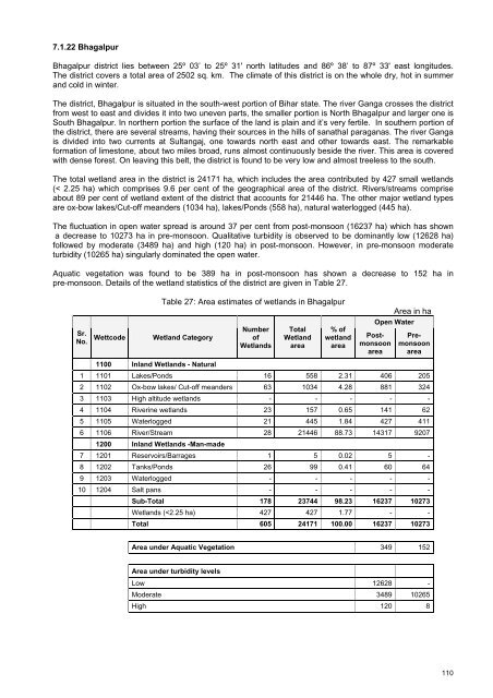
The total wetl<strong>and</strong> area in the district is 24171 ha, which includes the area contributed by 427 small wetl<strong>and</strong>s<br />
(< 2.25 ha) which comprises 9.6 per cent <strong>of</strong> the geographical area <strong>of</strong> the district. Rivers/streams comprise<br />
about 89 per cent <strong>of</strong> wetl<strong>and</strong> extent <strong>of</strong> the district that accounts for 21446 ha. The other major wetl<strong>and</strong> types<br />
are ox-bow lakes/Cut-<strong>of</strong>f me<strong>and</strong>ers (1034 ha), lakes/Ponds (558 ha), natural waterlogged (445 ha).<br />
The fluctuation in open water spread is around 37 per cent from post-monsoon (16237 ha) which has shown<br />
a decrease to 10273 ha in pre-monsoon. Qualitative turbidity is observed to be dominantly low (12628 ha)<br />
followed by moderate (3489 ha) <strong>and</strong> high (120 ha) in post-monsoon. However, in pre-monsoon moderate<br />
turbidity (10265 ha) singularly dominated the open water.<br />
Aquatic vegetation was found to be 389 ha in post-monsoon has shown a decrease to 152 ha in<br />
pre-monsoon. Details <strong>of</strong> the wetl<strong>and</strong> statistics <strong>of</strong> the district are given in Table 27.<br />
Table 27: Area estimates <strong>of</strong> wetl<strong>and</strong>s in Bhagalpur<br />
Area in ha<br />
Sr.<br />
No.<br />
Wettcode<br />
Wetl<strong>and</strong> Category<br />
Number<br />
<strong>of</strong><br />
Wetl<strong>and</strong>s<br />
Total<br />
Wetl<strong>and</strong><br />
area<br />
% <strong>of</strong><br />
wetl<strong>and</strong><br />
area<br />
Open Water<br />
Postmonsoon<br />
area<br />
Premonsoon<br />
area<br />
1100 Inl<strong>and</strong> Wetl<strong>and</strong>s - Natural<br />
1 1101 Lakes/Ponds 16 558 2.31 406 205<br />
2 1102 Ox-bow lakes/ Cut-<strong>of</strong>f me<strong>and</strong>ers 63 1034 4.28 881 324<br />
3 1103 High altitude wetl<strong>and</strong>s - - - - -<br />
4 1104 Riverine wetl<strong>and</strong>s 23 157 0.65 141 62<br />
5 1105 Waterlogged 21 445 1.84 427 411<br />
6 1106 River/Stream 28 21446 88.73 14317 9207<br />
1200 Inl<strong>and</strong> Wetl<strong>and</strong>s -Man-made<br />
7 1201 Reservoirs/Barrages 1 5 0.02 5 -<br />
8 1202 Tanks/Ponds 26 99 0.41 60 64<br />
9 1203 Waterlogged - - - - -<br />
10 1204 Salt pans - - - - -<br />
Sub-Total 178 23744 98.23 16237 10273<br />
Wetl<strong>and</strong>s (


