

Bihar - Ministry of Environment and Forests
Bihar - Ministry of Environment and Forests
Bihar - Ministry of Environment and Forests
- No tags were found...

Create successful ePaper yourself
Turn your PDF publications into a flip-book with our unique Google optimized e-Paper software.
7.1.6 Supaul<br />
The district lies between 25 0 59’ to 26 0 34’ North latitudes <strong>and</strong> 86 0 23’ to 87 0 06’ East longitudes. The district<br />
covers a total area <strong>of</strong> 2985 sq. km. Hot summer, mildly cold winter <strong>and</strong> dry air, except during rainy season<br />
characterise the climate <strong>of</strong> the district. May is the hottest month with mean daily maximum temperature <strong>of</strong><br />
about 40 0 C, which may sometimes rise to 45 0 C. It starts decreasing by the middle <strong>of</strong> November.<br />
This district is a part <strong>of</strong> alluvial plain <strong>of</strong> Kosi River. It slopes from north to south <strong>and</strong> water <strong>of</strong> the area flows<br />
towards Kosi. It is a flood plain <strong>of</strong> the River Kosi <strong>and</strong> its tributaries. The flood plain <strong>of</strong> this river is very fertile.<br />
The total wetl<strong>and</strong> area in the district is 19285 ha, which includes the area contributed by 320small wetl<strong>and</strong>s<br />
(< 2.25 ha) which comprises about 6 per cent <strong>of</strong> the geographical area <strong>of</strong> the district. River/streams comprise<br />
about 95 per cent <strong>of</strong> wetl<strong>and</strong> extent <strong>of</strong> the district that accounts for 18286 ha. The other major wetl<strong>and</strong><br />
categories are natural waterlogged (436 ha) <strong>and</strong> lakes/ponds (194 ha).<br />
This district has shown a slight increase in the extent <strong>of</strong> open water from post-monsoon (9004 ha) to<br />
pre-monsoon (9021 ha) which is due to non-seasonal rainfall. Qualitative turbidity is observed to be<br />
dominantly low (3760 ha) followed by moderate (2659 ha) <strong>and</strong> high (2585 ha) in post-monsoon. However, in<br />
pre-monsoon moderate turbidity (9021 ha) singularly dominated the open water.<br />
Aquatic vegetation was found to be 381 ha in post-monsoon has shown a decrease to 126 ha in pre-monsoon.<br />
Details <strong>of</strong> the wetl<strong>and</strong> statistics <strong>of</strong> the district are given in Table 11.<br />
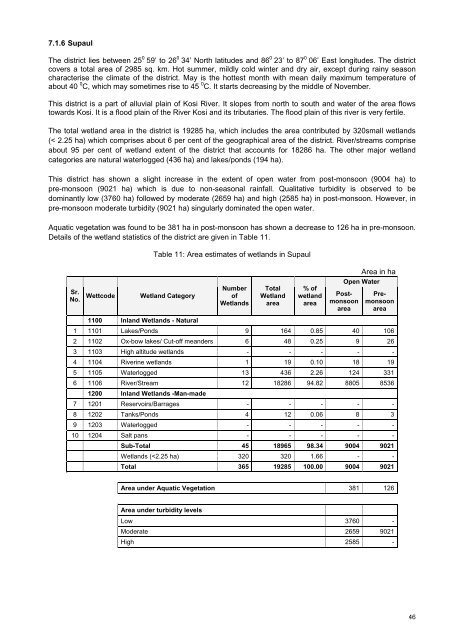
Table 11: Area estimates <strong>of</strong> wetl<strong>and</strong>s in Supaul<br />
Area in ha<br />
Sr.<br />
No.<br />
Wettcode<br />
Wetl<strong>and</strong> Category<br />
Number<br />
<strong>of</strong><br />
Wetl<strong>and</strong>s<br />
Total<br />
Wetl<strong>and</strong><br />
area<br />
% <strong>of</strong><br />
wetl<strong>and</strong><br />
area<br />
Open Water<br />
Postmonsoon<br />
area<br />
Premonsoon<br />
area<br />
1100 Inl<strong>and</strong> Wetl<strong>and</strong>s - Natural<br />
1 1101 Lakes/Ponds 9 164 0.85 40 106<br />
2 1102 Ox-bow lakes/ Cut-<strong>of</strong>f me<strong>and</strong>ers 6 48 0.25 9 26<br />
3 1103 High altitude wetl<strong>and</strong>s - - - - -<br />
4 1104 Riverine wetl<strong>and</strong>s 1 19 0.10 18 19<br />
5 1105 Waterlogged 13 436 2.26 124 331<br />
6 1106 River/Stream 12 18286 94.82 8805 8536<br />
1200 Inl<strong>and</strong> Wetl<strong>and</strong>s -Man-made<br />
7 1201 Reservoirs/Barrages - - - - -<br />
8 1202 Tanks/Ponds 4 12 0.06 8 3<br />
9 1203 Waterlogged - - - - -<br />
10 1204 Salt pans - - - - -<br />
Sub-Total 45 18965 98.34 9004 9021<br />
Wetl<strong>and</strong>s (


