

Bihar - Ministry of Environment and Forests
Bihar - Ministry of Environment and Forests
Bihar - Ministry of Environment and Forests
- No tags were found...

You also want an ePaper? Increase the reach of your titles
YUMPU automatically turns print PDFs into web optimized ePapers that Google loves.
7.1.31 Kaimur (Bhabua)<br />
The district lies between 24º 32’ to 25º 24' north latitudes <strong>and</strong> 83º 18’ to 83º 55' east longitudes. The district<br />
covers a total area <strong>of</strong> 1840 sq. km. The climate <strong>of</strong> this district is on the whole dry, hot in summer <strong>and</strong> mild cold<br />
in winter. The temperature in the district starts increasing from the beginning <strong>of</strong> March till May, which is<br />
generally the hottest month. After October, both day <strong>and</strong> night temperature decreases rapidly. January is<br />
usually the coldest month.<br />
Kaimur district is divided into to parts; the northern part is a feature less plain l<strong>and</strong> <strong>and</strong> the southern portion is<br />
forest. There is no such big river but small rivers <strong>and</strong> canals are present all over this district.<br />
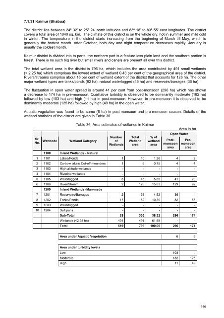
The total wetl<strong>and</strong> area in the district is 796 ha, which includes the area contributed by 491 small wetl<strong>and</strong>s<br />
(< 2.25 ha) which comprises the lowest extent <strong>of</strong> wetl<strong>and</strong> 0.43 per cent <strong>of</strong> the geographical area <strong>of</strong> the district.<br />
Rivers/streams comprise about 16 per cent <strong>of</strong> wetl<strong>and</strong> extent <strong>of</strong> the district that accounts for 126 ha. The other<br />
major wetl<strong>and</strong> types are tanks/ponds (82 ha), natural waterlogged (45 ha) <strong>and</strong> reservoirs/barrages (36 ha).<br />
The fluctuation in open water spread is around 41 per cent from post-monsoon (296 ha) which has shown<br />
a decrease to 174 ha in pre-monsoon. Qualitative turbidity is observed to be dominantly moderate (182 ha)<br />
followed by low (103 ha) <strong>and</strong> high (11 ha) in post-monsoon. However, in pre-monsoon it is observed to be<br />
dominantly moderate (125 ha) followed by high (49 ha) in the open water.<br />
Aquatic vegetation was found to be same (6 ha) in post-monsoon <strong>and</strong> pre-monsoon season. Details <strong>of</strong> the<br />
wetl<strong>and</strong> statistics <strong>of</strong> the district are given in Table 36.<br />
Table 36: Area estimates <strong>of</strong> wetl<strong>and</strong>s in Kaimur<br />
Area in ha<br />
Sr.<br />
No.<br />
Wettcode<br />
Wetl<strong>and</strong> Category<br />
Number<br />
<strong>of</strong><br />
Wetl<strong>and</strong>s<br />
Total<br />
Wetl<strong>and</strong><br />
area<br />
% <strong>of</strong><br />
wetl<strong>and</strong><br />
area<br />
Open Water<br />
Postmonsoon<br />
area<br />
Premonsoon<br />
area<br />
1100 Inl<strong>and</strong> Wetl<strong>and</strong>s - Natural<br />
1 1101 Lakes/Ponds 1 10 1.26 4 2<br />
2 1102 Ox-bow lakes/ Cut-<strong>of</strong>f me<strong>and</strong>ers 1 6 0.75 4 4<br />
3 1103 High altitude wetl<strong>and</strong>s - - - - -<br />
4 1104 Riverine wetl<strong>and</strong>s - - - - -<br />
5 1105 Waterlogged 5 45 5.65 41 20<br />
6 1106 River/Stream 2 126 15.83 129 92<br />
1200 Inl<strong>and</strong> Wetl<strong>and</strong>s -Man-made<br />
7 1201 Reservoirs/Barrages 2 36 4.52 36 -<br />
8 1202 Tanks/Ponds 17 82 10.30 82 56<br />
9 1203 Waterlogged - - - - -<br />
10 1204 Salt pans - - - - -<br />
Sub-Total 28 305 38.32 296 174<br />
Wetl<strong>and</strong>s (


