

Bihar - Ministry of Environment and Forests
Bihar - Ministry of Environment and Forests
Bihar - Ministry of Environment and Forests
- No tags were found...

Create successful ePaper yourself
Turn your PDF publications into a flip-book with our unique Google optimized e-Paper software.
7.1.35 Gaya<br />
The district lies between 24º 15’ to 25º 15' north latitudes <strong>and</strong> 84º 16’ to 85º 24' east longitudes. The district<br />
covers a total area <strong>of</strong> 4941 sq. km. The climate <strong>of</strong> this district is on the whole dry, hot in summer <strong>and</strong> mild cold<br />
in winter.<br />
The district <strong>of</strong> Gaya is broadly divided into two distinct physical units. The south is a region <strong>of</strong> broken<br />
undulating country merging into long ranges <strong>of</strong> hills, with a wide belt <strong>of</strong> brushwood jungle at their base.<br />
The greater part <strong>of</strong> the district, however, consists <strong>of</strong> the flat alluvial plain. Since the highl<strong>and</strong>s lie in the<br />
southern <strong>and</strong> lowl<strong>and</strong>s in the northern parts <strong>of</strong> the district, the river take their rise in the highl<strong>and</strong> <strong>of</strong> the Chota<br />
Nagpur Plateau <strong>and</strong> flow from south to north in almost parallel courses. On account <strong>of</strong> the seasonal character<br />
<strong>of</strong> rainfall the stream suffers from a lack <strong>of</strong> perennial supply <strong>of</strong> water in them, <strong>and</strong> hence they are turbulent <strong>and</strong><br />
devastating during the rains but are reduce to tiny rivulets winding in tortuous course over wide s<strong>and</strong>y beds<br />
soon after the rainy season is over.<br />
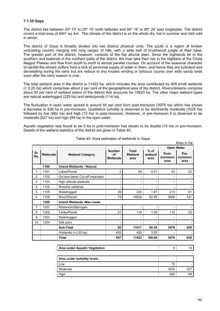
The total wetl<strong>and</strong> area in the district is 11422 ha, which includes the area contributed by 405 small wetl<strong>and</strong>s<br />
(< 2.25 ha) which comprises about 2 per cent <strong>of</strong> the geographical area <strong>of</strong> the district. Rivers/streams comprise<br />
about 93 per cent <strong>of</strong> wetl<strong>and</strong> extent <strong>of</strong> the district that accounts for 10620 ha. The other major wetl<strong>and</strong> types<br />
are natural waterlogged (225 ha) <strong>and</strong> tanks/ponds (114 ha).<br />
The fluctuation in open water spread is around 84 per cent from post-monsoon (3979 ha) which has shown<br />
a decrease to 626 ha in pre-monsoon. Qualitative turbidity is observed to be dominantly moderate (3025 ha)<br />
followed by low (882 ha) <strong>and</strong> high (72 ha) in post-monsoon. However, in pre-monsoon it is observed to be<br />
moderate (527 ha) <strong>and</strong> high (99 ha) in the open water.<br />
Aquatic vegetation was found to be 5 ha in post-monsoon has shown to be double (10 ha) in pre-monsoon.<br />
Details <strong>of</strong> the wetl<strong>and</strong> statistics <strong>of</strong> the district are given in Table 40.<br />
Table 40: Area estimates <strong>of</strong> wetl<strong>and</strong>s in Gaya<br />
Area in ha<br />
Sr.<br />
No.<br />
Wettcode<br />
Wetl<strong>and</strong> Category<br />
Number<br />
<strong>of</strong><br />
Wetl<strong>and</strong>s<br />
Total<br />
Wetl<strong>and</strong><br />
area<br />
% <strong>of</strong><br />
wetl<strong>and</strong><br />
area<br />
Open Water<br />
Postmonsoon<br />
area<br />
Premonsoon<br />
area<br />
1100 Inl<strong>and</strong> Wetl<strong>and</strong>s - Natural<br />
1 1101 Lakes/Ponds 3 58 0.51 53 52<br />
2 1102 Ox-bow lakes/ Cut-<strong>of</strong>f me<strong>and</strong>ers - - - - -<br />
3 1103 High altitude wetl<strong>and</strong>s - - - - -<br />
4 1104 Riverine wetl<strong>and</strong>s - - - - -<br />
5 1105 Waterlogged 39 225 1.97 214 81<br />
6 1106 River/Stream 19 10620 92.98 3600 441<br />
1200 Inl<strong>and</strong> Wetl<strong>and</strong>s -Man-made<br />
7 1201 Reservoirs/Barrages - - - - -<br />
8 1202 Tanks/Ponds 31 114 1.00 112 52<br />
9 1203 Waterlogged - - - - -<br />
10 1204 Salt pans - - - - -<br />
Sub-Total 92 11017 96.45 3979 626<br />
Wetl<strong>and</strong>s (


