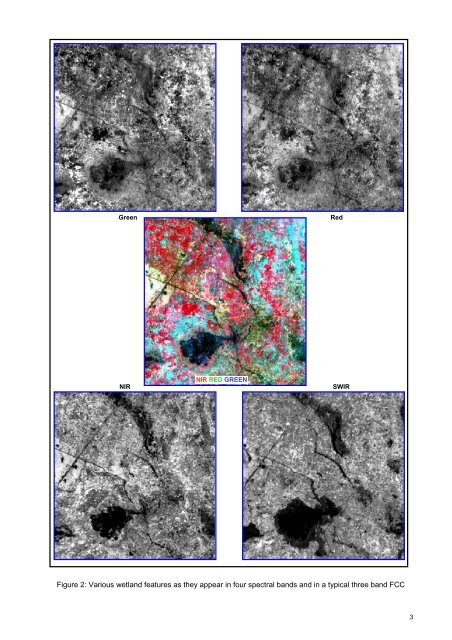
importance is the remote sensing <strong>and</strong> geographic information system (GIS) technique. Remote sensing is now recognized as an essential tool for viewing, analyzing, characterizing, <strong>and</strong> making decisions about l<strong>and</strong>, water <strong>and</strong> atmospheric components. From a general perspective, remote sensing is the science <strong>of</strong> acquiring <strong>and</strong> analyzing information about objects or phenomena from a distance (Jensen, 1986; Lilles<strong>and</strong> <strong>and</strong> Keifer, 1987). Today, we define satellite remote sensing as the use <strong>of</strong> satellite borne sensors to observe, measure, <strong>and</strong> record the electromagnetic radiation (EMR) reflected or emitted by the earth <strong>and</strong> its environment for subsequent analysis <strong>and</strong> extraction <strong>of</strong> information. EMR sensors includes visible light, near-, mid- <strong>and</strong> far-infrared (thermal), microwave, <strong>and</strong> long-wave radio energy. The capability <strong>of</strong> multiple sources <strong>of</strong> information is unique to remote sensing. Of specific advantage is the spectral, temporal, <strong>and</strong> spatial resolution. Spectral resolution refers to the width or range <strong>of</strong> each spectral b<strong>and</strong> being recorded. Since each target affects different wavelengths <strong>of</strong> incident energy differently, they are absorbed, reflected or transmitted in different proportions. Currently, there are many l<strong>and</strong> resource remote sensing satellites that have sensors operating in the green, red, near infrared <strong>and</strong> short wave Infra red regions <strong>of</strong> the electromagnetic spectrum giving a definite spectral signature <strong>of</strong> various targets due to difference in radiation absorption <strong>and</strong> reflectance <strong>of</strong> targets. These sensors are <strong>of</strong> common use for l<strong>and</strong> cover studies, including wetl<strong>and</strong>s. Figure 1 shows typical spectral signature <strong>of</strong> few targets from green to SWIR region. Converted to image, in a typical false colour composite (FCC) created using NIR, red <strong>and</strong> green b<strong>and</strong>s assigned as red, green <strong>and</strong> blue colour, the features become very distinct as shown in Figure 2 - a typical wetl<strong>and</strong> located in Purba Champaran district. In FCC, the vegetation thus appears invariably red (due to high reflection in NIR from green leaves). Since the early 1960s, numerous satellite sensors have been launched into orbit to observe <strong>and</strong> monitor the earth <strong>and</strong> its environment. Most early satellite sensors acquired data for meteorological purposes. The advent <strong>of</strong> earth resources satellite sensors (those with a primary objective <strong>of</strong> mapping <strong>and</strong> monitoring l<strong>and</strong> cover) occurred, when the first L<strong>and</strong>sat satellite was launched in July 1972. Currently, more than a dozen orbiting satellites <strong>of</strong> various types provide data crucial to improving our knowledge <strong>of</strong> the earth’s atmosphere, oceans, ice <strong>and</strong> snow, <strong>and</strong> l<strong>and</strong>. Of particular interest to India is the indigenous series <strong>of</strong> satellites called Indian Remote Sensing satellites (IRS-Series). Since the launch <strong>of</strong> the first satellite IRS 1A in 1987, India has now a number <strong>of</strong> satellites providing data in multi-spectral b<strong>and</strong>s with different spatial resolution. IRS P6/RESOURCESAT 1 is the current generation satellite that provides multi-spectral images in spatial resolution <strong>of</strong> 5.8 m (LISS IV), 23.5 m (LISS III) <strong>and</strong> 56m (AWiFS). Over the past few decades, IRS series data has been successfully used in various fields <strong>of</strong> natural resources ( Navalgund et al, 2002 ). Development <strong>of</strong> technologies like Geographic Information System (GIS) has enhanced the use <strong>of</strong> RS data to obtain accurate geospatial database. GIS specialises in h<strong>and</strong>ling related, spatially referenced data, combining mapped information with other data <strong>and</strong> acts as analytical tool for research <strong>and</strong> decision making. During the past few decades, technological advances in the field <strong>of</strong> satellite remote sensing (RS) sensors, computerized mapping techniques, global positioning system (GPS) <strong>and</strong> geographic information system (GIS) has enhanced the ability to capture more detailed <strong>and</strong> timely information about the natural resources at various scales catering to local, regional, national <strong>and</strong> global level study. Figure 1: Spectral Signature <strong>of</strong> various targets 2
Green Red NIR NIR RED GREEN SWIR Figure 2: Various wetl<strong>and</strong> features as they appear in four spectral b<strong>and</strong>s <strong>and</strong> in a typical three b<strong>and</strong> FCC 3
- Page 1 and 2: NATIONAL WETLAND ATLAS: BIHAR Spons
- Page 3 and 4: Atlas SAC/RESA/AFEG/NWIA/ATLAS/23/2
- Page 5: MESSAGE It gives me great pleasure
- Page 9: ACKNOWLEDGEMENTS The project “Nat
- Page 13 and 14: CONTENTS 1.0 INTRODUCTION 1.1 Wetla
- Page 15: Table 35: Area estimates of wetland
- Page 20 and 21: 1.3 Wetland Inventory of India Indi
- Page 22 and 23: • Aquatic vegetation spread: The
- Page 24 and 25: Figure 3: Location Map Figure 4: Sp
- Page 26 and 27: Ground truth data Remotely sensed d
- Page 28 and 29: The indices were generated using st
- Page 30 and 31: 6.0 ACCURACY ASSESSMENT A comprehen
- Page 33: MAPS AND STATISTICS 17
- Page 36: Figure 10: Type-wise wetland distri
- Page 41 and 42: Figure 11: District-wise graphical
- Page 46: 7.1.2 Purba Champaran The Purba Cha
- Page 54: 7.1.4 Sitamarhi The Sitamarhi distr
- Page 62: 7.1.6 Supaul The district lies betw
- Page 70:
7.1.8 Kishanganj The Kishanganj dis
- Page 78:
7.1.10 Katihar The district Katihar
- Page 86:
7.1.12 Saharsa The district lies be
- Page 94:
7.1.14 Muzaffarpur The district lie
- Page 102:
7.1.16 Siwan Siwan district lies be
- Page 110:
7.1.18 Vaishali Vaishali district l
- Page 116 and 117:
100
- Page 118 and 119:
7.1.20 Begusarai The district lies
- Page 120 and 121:
104
- Page 122 and 123:
7.1.21 Khagaria The district lies b
- Page 124 and 125:
108
- Page 126 and 127:
7.1.22 Bhagalpur Bhagalpur district
- Page 128 and 129:
112
- Page 130 and 131:
7.1.23 Banka The district lies betw
- Page 132 and 133:
116
- Page 134 and 135:
7.1.24 Munger The district lies bet
- Page 136 and 137:
120
- Page 138 and 139:
7.1.25 Lakhisarai The district lies
- Page 140 and 141:
124
- Page 142 and 143:
7.1.26 Sheikhpura The district lies
- Page 144 and 145:
128
- Page 146 and 147:
7.1.27 Nalanda The district lies be
- Page 148 and 149:
132
- Page 150 and 151:
7.1.28 Patna Patna district lies be
- Page 152 and 153:
136
- Page 154 and 155:
7.1.29 Bhojpur The district lies be
- Page 156 and 157:
140
- Page 158 and 159:
7.1.30 Buxar The district lies betw
- Page 160 and 161:
144
- Page 162 and 163:
7.1.31 Kaimur (Bhabua) The district
- Page 164 and 165:
148
- Page 166 and 167:
7.1.32 Rohtas The district lies bet
- Page 168 and 169:
152
- Page 170 and 171:
7.1.33 Jehanabad The district lies
- Page 172 and 173:
156
- Page 174 and 175:
7.1.34 Aurangabad The district lies
- Page 176 and 177:
160
- Page 178 and 179:
7.1.35 Gaya The district lies betwe
- Page 180 and 181:
164
- Page 182 and 183:
7.1.36 Nawada The district lies bet
- Page 184 and 185:
168
- Page 186 and 187:
7.1.37 Jamui The district lies betw
- Page 188 and 189:
172
- Page 190 and 191:
174
- Page 192 and 193:
176
- Page 194 and 195:
Sr. No. Description Field Photograp
- Page 196 and 197:
Sr. No. Description Field Photograp
- Page 198 and 199:
182
- Page 200 and 201:
9.1 Khabar Tal Wetland Type: Natura
- Page 202 and 203:
186
- Page 204 and 205:
9.2 Moti Jheel Wetland Type: Ox-bow
- Page 206 and 207:
190
- Page 208 and 209:
9.3 Mora Mahananda Tal Wetland Type
- Page 210 and 211:
194
- Page 212 and 213:
9.4 Bawlee Chaur Wetland Type: Natu
- Page 214 and 215:
198
- Page 216 and 217:
9.5 Kosi/Belasi Dam Wetland Type: R
- Page 218 and 219:
202
- Page 220 and 221:
204
- Page 222 and 223:
206
- Page 224 and 225:
208
- Page 226 and 227:
210
- Page 228 and 229:
212
- Page 230 and 231:
214
- Page 232 and 233:
216
- Page 234 and 235:
218
- Page 236 and 237:
1202 Tanks/Ponds: A term used in Ce
- Page 238 and 239:
222
- Page 240:
Space Applications centre Indian Sp