

Bihar - Ministry of Environment and Forests
Bihar - Ministry of Environment and Forests
Bihar - Ministry of Environment and Forests
- No tags were found...

You also want an ePaper? Increase the reach of your titles
YUMPU automatically turns print PDFs into web optimized ePapers that Google loves.
7.1.12 Saharsa<br />
The district lies between 25º 35’ to 26º 04' north latitudes <strong>and</strong> 86º 18’ to 86º 52' east longitudes. The district<br />
covers a total area <strong>of</strong> 1196 sq. km. The climate <strong>of</strong> this district is on the whole dry, hot in summer <strong>and</strong> cold in<br />
winter.<br />
The district is formed by alluvial &alluvium plain. The slope <strong>of</strong> the district is generally from north to south with a<br />
slight inclination eastward. There are innumerable channels <strong>of</strong> Kosi River. There is no highl<strong>and</strong> in the district<br />
excepting a few embankments. So in rainy season the Kosi River has wrought more ravages by flood.<br />
There is large number <strong>of</strong> marshes scattered throughout the district. They mostly occurred on either side <strong>of</strong> the<br />
river. A number <strong>of</strong> marshes have now been reclaimed or have been filled up & yielding some crop.<br />
The total wetl<strong>and</strong> area in the district is 12086 ha including 223 small wetl<strong>and</strong>s having area less than 2.25 ha<br />
which comprises the highest extent <strong>of</strong> wetl<strong>and</strong> about 10 per cent <strong>of</strong> the geographical area <strong>of</strong> the district.<br />
Rivers/streams contribute almost 70 per cent <strong>of</strong> wetl<strong>and</strong> extent <strong>of</strong> the district that accounts for 8502 ha.<br />
After rivers/streams, natural waterlogged (2501 ha), lakes/ponds (546 ha) <strong>and</strong> ox-bow lakes/cut-<strong>of</strong>f me<strong>and</strong>ers<br />
(241 ha) are the major wetl<strong>and</strong> category <strong>of</strong> the district.<br />
Water spread is 7202 ha in post-monsoon which is decreased 43 per cent in pre-monsoon (4125 ha).<br />
Qualitative turbidity is observed to be dominantly moderate (3209 ha) followed by low (2405 ha) <strong>and</strong> high<br />
(1508ha) in post-monsoon season. However, in pre-monsoon turbidity is observed to be moderate (4110 ha)<br />
<strong>and</strong> high (15 ha) in the open water.<br />
Out <strong>of</strong> 11863 ha, 1752 ha <strong>and</strong> 738 ha area is infested by aquatic vegetation in post <strong>and</strong> pre-monsoon season<br />
respectively. Details <strong>of</strong> the wetl<strong>and</strong> statistics <strong>of</strong> the district are given in Table 17.<br />
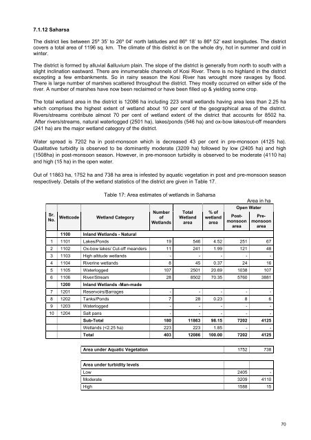
Table 17: Area estimates <strong>of</strong> wetl<strong>and</strong>s in Saharsa<br />
Area in ha<br />
Sr.<br />
No.<br />
Wettcode<br />
Wetl<strong>and</strong> Category<br />
Number<br />
<strong>of</strong><br />
Wetl<strong>and</strong>s<br />
Total<br />
Wetl<strong>and</strong><br />
area<br />
% <strong>of</strong><br />
wetl<strong>and</strong><br />
area<br />
Open Water<br />
Postmonsoon<br />
area<br />
Premonsoon<br />
area<br />
1100 Inl<strong>and</strong> Wetl<strong>and</strong>s - Natural<br />
1 1101 Lakes/Ponds 19 546 4.52 251 67<br />
2 1102 Ox-bow lakes/ Cut-<strong>of</strong>f me<strong>and</strong>ers 11 241 1.99 121 48<br />
3 1103 High altitude wetl<strong>and</strong>s - - - - -<br />
4 1104 Riverine wetl<strong>and</strong>s 8 45 0.37 24 16<br />
5 1105 Waterlogged 107 2501 20.69 1038 107<br />
6 1106 River/Stream 28 8502 70.35 5760 3881<br />
1200 Inl<strong>and</strong> Wetl<strong>and</strong>s -Man-made<br />
7 1201 Reservoirs/Barrages - - - - -<br />
8 1202 Tanks/Ponds 7 28 0.23 8 6<br />
9 1203 Waterlogged - - - - -<br />
10 1204 Salt pans - - - - -<br />
Sub-Total 180 11863 98.15 7202 4125<br />
Wetl<strong>and</strong>s (


