PDF COPY - Manuel berberian
PDF COPY - Manuel berberian
PDF COPY - Manuel berberian

You also want an ePaper? Increase the reach of your titles
YUMPU automatically turns print PDFs into web optimized ePapers that Google loves.
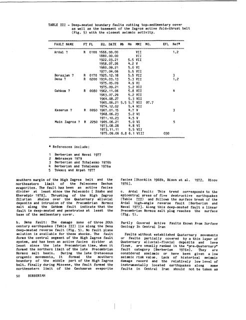
TABLE III - Deep-seated boundary faults cutting top-sedimentary cover<br />
as well as the basement o£ the Zagros active fold-thrust belt<br />
(Fig. 5) with the closest seismic activity.<br />
FAULT NAME FT FL EO. DATE Mb Ms MMI MO. EFL ReP<br />
krdal R 0100 1666.00.00 VII 1,2<br />
1880.00.00 VII<br />
1922.03.21 5.5 VII<br />
1958.07.26 ~.2 V<br />
1960.09.21 5.0 VI<br />
1977.0~.06 5.5 VII<br />
Borazjan R 0170 1925.12.~8 5.5 VII<br />
Dena R 0200 193~.03.13 5.3 VII 1,2<br />
1975.05.09 q.9 VI<br />
1975.09.21 5.2 VII<br />
Gahkom R 0080 1962.11.06 5.8 VII<br />
1963.07.29 5.2 VII<br />
196~.08.27 5.3 VII<br />
1965.06.21 5.5 5.7 VII 07.7<br />
197~.12.02 5.q VII<br />
Kazerun R 0050 1967.01.15 q.7 V 3<br />
1968.06.23 5.2 VI<br />
1971.10.23 q.5 V<br />
Main Zagros R 2250 1965.06.21 5.0 VI 5<br />
1973.08.28 q.8 VI<br />
1973.11.11 5.5 VII<br />
1975.09.06 6.8 6.1 VIII 030<br />
References<br />
include:<br />
1 Berberian and Navai 1977<br />
2 Ambraseys 1979<br />
3 Berbertan and Tchalenko 1976b<br />
~ Berberian and Tchalenko 1976a<br />
5 Toksoz and Arpat 1977<br />
southern margin of the High Zagros belt and the<br />
northeastern limit of the Paleocene Sachun<br />
evaporltes. The fault has been an active facies<br />
divider at least since the Paleozolc [ Szabo and<br />
Kheradplr 1978]. Thrusting of the High Zagros<br />
Silurian shales over the Q~aternary alluvial<br />
deposits and intrusion of the Precambrian Hormoz<br />
salt along the Gahkom fault indicate that the<br />
fault is deep-seated and penetrates at least the<br />
base of the sedimentary cover.<br />
b. Dena Fault: The damage zone o£ three 20th<br />
century earthquakes (Table III) lie along the Dena<br />
deep-seated reverse fault (Fig. 5). No fault plane<br />
solution is available for these shocks. The fault<br />
forms the central segment of the High Zagros fault<br />
system, and has been an active faeles divider at<br />
least since the late Precambrian time, when it<br />
formed the northern limit of the late Precambrian<br />
Hormoz salt basin. During the late Cretaceous<br />
orogenic movements, it formed the southern<br />
boundary of the middle part of the High Zagros<br />
belt. Finally during Miocene, the fault formed the<br />
northeastern limit of the Gachsaran evaporlte<br />
facies [Stoeklin 1968b, Bizon et al. 1972, Rleou<br />
1976].<br />
c. Ardal Fault: This trend corresponds to the<br />
epicentral areas of five destructive earthquakes<br />
(Table III) and follows the surface break of the<br />
Ardal high-angle reverse fault [Berberian and<br />
Navai 1977]. Along this deep-seated fault a linear<br />
Precambrian Hormoz salt plug reaches the surface<br />
(Fig. 5).<br />
Partly Covered Active Faults Known. From Surface<br />
Geology In Central Iran<br />
Faults without established Quaternary movements<br />
or faults partially covered by a thin layer of<br />
Quaternary alluvial-fluvial deposits and lava<br />
flows, are usually ranked in the "pre-Quaternary"<br />
fault category [Berberian 1976e]. They are<br />
considered aselsmie or have been given a low<br />
seismic risk value. Lack of historical seismic<br />
damage record and the relatively low level of<br />
instrumentally located earthquakes along some<br />
faults in Central Iran should not be taken as<br />
50 BERBERIAN