PDF COPY - Manuel berberian
PDF COPY - Manuel berberian
PDF COPY - Manuel berberian

You also want an ePaper? Increase the reach of your titles
YUMPU automatically turns print PDFs into web optimized ePapers that Google loves.
o<br />
too<br />
GULF OF OMAN<br />
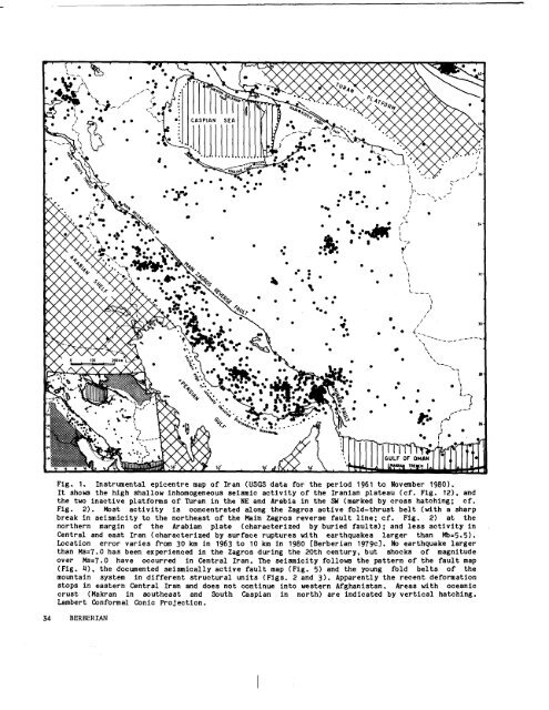
Fig. I, Instrumental epic¯hire map of Iran (USGS data for the period 1961 to November 1980).<br />
It shows the high shallow inhomogeneous selsmLe activity of the Iranlan plateau (el. F18. 12). and<br />
the two inactive platforms of ~uran in the NE and Arabia in the ~ (marked by cross hatching;<br />
Fig. 2). Host activity is concentrated along the Zagros active fold-thrust belt (with a sharp<br />
break in seismielty to the northeast of the Main Zagros reverae fault llne; el, Fig, 2) at the<br />
northern margin of the Arabian plate (charaeterlzed by buried faults); and leas aetlvity<br />
Central and east Iran (characterized by surface ruptures with earthquakea larger than<br />
Location error varies ~rom ~0 km in 1963 to 10 km Ln 1980 [Berber/an 1979e]. No earthquake larger<br />
than Ms=~,O has been experleneed in the Zagros during the 20th century, but shocks of magnitude<br />
over Ms=7.0 have occurred in Central Iran. The selsmLeLty follows the pattern of the fault map<br />
(Fig. ~), the documented selsmieally aetlve fault map (Fig, 5) and the young fold belts of<br />
mountai~ system in different structural units (Figs. 2 and 3). Apparently the recent deformation<br />
stops in eastern Central Iran and does not continue into western Afghanistan. ~reas with oceanic<br />
crust (Makran in southeast and South Caspian in north) are indlcated by vertical hatching.<br />
Lambert Conformal Conic Pro~eetion.<br />
34<br />
BERBER]AN