Sutton Common Updated project design - University of Exeter
Sutton Common Updated project design - University of Exeter
Sutton Common Updated project design - University of Exeter

Create successful ePaper yourself
Turn your PDF publications into a flip-book with our unique Google optimized e-Paper software.
<strong>Sutton</strong> <strong>Common</strong><br />
<strong>Updated</strong> <strong>project</strong> <strong>design</strong><br />
(including assessment report and statement <strong>of</strong> potential)<br />
by Robert Van de Noort, FSA MIFA<br />
Department <strong>of</strong> Archaeology<br />
<strong>University</strong> <strong>of</strong> <strong>Exeter</strong><br />
v 1.2<br />
21 April 2004<br />
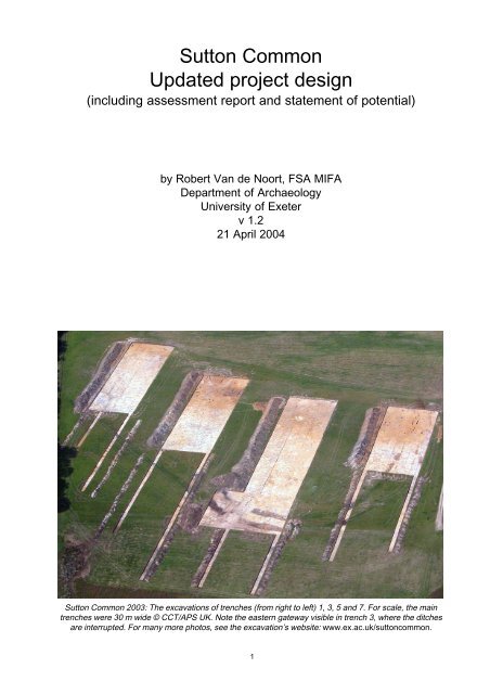
<strong>Sutton</strong> <strong>Common</strong> 2003: The excavations <strong>of</strong> trenches (from right to left) 1, 3, 5 and 7. For scale, the main<br />
trenches were 30 m wide © CCT/APS UK. Note the eastern gateway visible in trench 3, where the ditches<br />
are interrupted. For many more photos, see the excavation’s website: www.ex.ac.uk/suttoncommon.<br />
1
Contents<br />
Acknowledgements ...........................................................................................................................................................................................................................3<br />
The <strong>Sutton</strong> <strong>Common</strong> Project .................................................................................................................................................................................................4<br />
1 Background ............................................................................................................................................................................................................................................5<br />
1.1 Summary <strong>of</strong> the original academic objectives ..............................................................................................................6<br />
1.2 A summary <strong>of</strong> the results <strong>of</strong> the <strong>project</strong> to date ..........................................................................................................8<br />
2 Summary statement <strong>of</strong> potential ............................................................................................................................................................................. 13<br />
2.1 Archaeological features ......................................................................................................................................................................... 13<br />
2.2 Archaeological wood ................................................................................................................................................................................. 13<br />
2.3 Dendrochronology and radiocarbon dating .................................................................................................................. 14<br />
2.4 Small finds .............................................................................................................................................................................................................. 15<br />
2.5 Human remains ............................................................................................................................................................................................... 15<br />
2.6 Faunal remains ................................................................................................................................................................................................. 16<br />
2.7 Geology ...................................................................................................................................................................................................................... 16<br />
2.8 Palynology ..............................................................................................................................................................................................................17<br />
2.9 Macr<strong>of</strong>ossils ......................................................................................................................................................................................................... 18<br />
2.10 Geoarchaeology .............................................................................................................................................................................................. 18<br />
3 Aims and objectives ................................................................................................................................................................................................................ 20<br />
3.1 Academic or post-excavation research <strong>design</strong> ........................................................................................................ 20<br />
3.2 Publication and presentation .......................................................................................................................................................... 24<br />
4 Methods statement .................................................................................................................................................................................................................. 28<br />
4.1 General statement ........................................................................................................................................................................................ 28<br />
4.2 Task list ...................................................................................................................................................................................................................... 28<br />
5 Resources and programming ..................................................................................................................................................................................... 32<br />
5.1 Staffing and equipment .......................................................................................................................................................................... 32<br />
5.2 Timetable ................................................................................................................................................................................................................. 34<br />
5.3 Budget ......................................................................................................................................................................................................................... 35<br />
Bibliography ............................................................................................................................................................................................................................................ 36<br />
Appendix 1: Chronological overview <strong>of</strong> archaeological interventions at <strong>Sutton</strong> <strong>Common</strong> ................ 39<br />
2
Acknowledgements<br />
In the preparation <strong>of</strong> this <strong>Updated</strong> Project Design, I would like to thank all the specialists who<br />
have contributed to the various reports and provided information: Henry Chapman, Gavin<br />
Thomas, Nigel Nayling, Alex Bayliss, William Fletcher, Benjamin Gearey, Allan Hall, Harry<br />
Kenward, Malcolm Lillie, Helen Fenwick, JD Hill, Colin Patrick, Julian Henderson, Susan Watts,<br />
Chris Cumberpatch, Gianna Ayala, Jackie McKinley, Bruce Bradley, Francis Issett, Alan<br />
Outram, Ian Panter and Tina Tuhoy. I would also like to thank the EH reviewers, Helen Keeley,<br />
Keith May and Sarah Cross for their advice during the writing <strong>of</strong> this document, and Ian<br />
Carstairs and Henry Chapman for comments on an earlier drafts <strong>of</strong> this UPD.<br />
3
The <strong>Sutton</strong> <strong>Common</strong> Project<br />
The Excavations <strong>of</strong> the Iron Age Enclosures at <strong>Sutton</strong> <strong>Common</strong> are funded by English Heritage<br />
and are being undertaken by the Department <strong>of</strong> Archaeology, <strong>University</strong> <strong>of</strong> <strong>Exeter</strong> and the<br />
Wetland Archaeology and Environments Research Centre, <strong>University</strong> <strong>of</strong> Hull. The work forms<br />
a major part <strong>of</strong> the <strong>Sutton</strong> <strong>Common</strong> Project.<br />
The <strong>Sutton</strong> <strong>Common</strong> Project, which includes land acquisitions, wildlife and landscape<br />
enhancement, archaeological and palaeoenvironmental evaluations, research and<br />
conservation, and engineering works to raise ground-water levels, is spearheaded by the<br />
owners <strong>of</strong> the land, the Carstairs Countryside Trust (CCT), in partnership with English Heritage,<br />
English Nature, Countryside Agency, the Universities <strong>of</strong> <strong>Exeter</strong> and Hull and Grantham Brundell<br />
and Farran.<br />
The Project forms one <strong>of</strong> the Countryside Agency’s trial schemes in the Humberhead Levels<br />
‘Value in Wetness’ Land Management Initiative, which is seeking new, economically viable<br />
and environmentally sustainable approaches to water and land management in the<br />
Humberhead levels.<br />
Participation with the Askern Ward Community Partnership over future public access and<br />
enjoyment <strong>of</strong> the site seeks to contribute to the environmental and economic regeneration <strong>of</strong><br />
this ‘Coalfields’ area in South Yorkshire.<br />
This Project has been made possible through the co-operation <strong>of</strong> the Sheard Family Trust<br />
and financial support from: English Heritage, Heritage Lottery Fund, English Nature,<br />
Countryside Agency, DEFRA (Countryside Stewardship Scheme), Darrington Quarries (Landfill<br />
Tax Credits) through WREN - Waste Recycling Environmental, James Goodhart, The Pilgrim<br />
Trust and the Universities <strong>of</strong> <strong>Exeter</strong> and Hull. Help has also been given by the Doncaster<br />
Naturalists Society and Doncaster Arts (DARTS).<br />
<strong>Sutton</strong> <strong>Common</strong> in 1997: ploughed-out and drying out. The smaller enclosure is visible as an earthwork;<br />
the larger enclosure as an soilmark, with the peats <strong>of</strong> the Hampole Beck showing up as darker soil marks<br />
© CCT / APS UK<br />
4
1 Background<br />
‘<strong>Sutton</strong> <strong>Common</strong>’ is the name used by the Ordnance Survey for three fields centred on<br />
SE563122, approximately 500 m to the south <strong>of</strong> Askern Town, 8 km north <strong>of</strong> Doncaster in<br />
South Yorkshire. The village <strong>of</strong> <strong>Sutton</strong> and its <strong>Common</strong> form now part <strong>of</strong> the Parish <strong>of</strong> Norton<br />
and Campsall. The name has also been used for an Iron Age period site here formed by two<br />
‘enclosures’, which are dissected by a palaeochannel named the Hampole Beck (South<br />
Yorkshire scheduled monument 291).<br />
The site has had a long history <strong>of</strong> archaeological interventions, which is summarised in<br />
Appendix A. The most notable intervention at <strong>Sutton</strong> <strong>Common</strong> over the past 160 years were<br />
excavations in 1933, 1934 and 1935 under the direction <strong>of</strong> Emeritus Pr<strong>of</strong>essor Whiting, which<br />
were published in the Yorkshire Archaeological Journal in 1936 (Whiting 1936). These<br />
excavations are <strong>of</strong> particular importance to our understanding <strong>of</strong> the site as the earthworks <strong>of</strong><br />
both enclosures were still upstanding. Further work was undertaken by the South Yorkshire<br />
Archaeology Unit and the <strong>University</strong> <strong>of</strong> Sheffield following the partial destruction and subsequent<br />
drainage <strong>of</strong> the site in the early 1980s. A synthesis <strong>of</strong> these activities was published in the<br />
Proceedings <strong>of</strong> the Prehistoric Society by Mike Parker Pearson and Bob Sydes (Parker Pearson<br />
and Sydes 1997). This paper formed the basis for the <strong>project</strong> <strong>design</strong> <strong>of</strong> the excavations<br />
undertaken by the Universities <strong>of</strong> <strong>Exeter</strong> and Hull in 1998, 1999, 2002 and 2003.<br />
In 1998 and 1999, a series <strong>of</strong> trial trenches were excavated. The excavations in 1998 echoed<br />
earlier work in that it showed that only the basal 20 cm <strong>of</strong> ditch deposits (represented by a<br />
blue clay) within the smaller enclosure were waterlogged and could continue to preserve any<br />
organic archaeological and palaeoenvironmental remains here. Within the larger enclosure<br />
the results indicated elaborate gateways on the eastern and western sides with massive oak<br />
posts, which were desiccating rapidly (Van de Noort & Chapman 1999). A second more<br />
systematic <strong>project</strong> <strong>of</strong> excavation was undertaken in 1999 (Van de Noort & Chapman 2000).<br />
This <strong>project</strong> established the alphanumeric excavation grid across the site and identified the<br />
survival <strong>of</strong> a range <strong>of</strong> internal features within the larger enclosure, including wood in varying<br />
stages <strong>of</strong> desiccation.<br />
The <strong>project</strong> <strong>design</strong> for the excavations in 2002 and 2003 was submitted to English Heritage in<br />
January 2001. It had been intended to complete the fieldwork by the end <strong>of</strong> 2002, but the<br />
onset <strong>of</strong> Foot and Mouth Disease in England in the (wet) spring <strong>of</strong> 2001 forced a considerable<br />
delay <strong>of</strong> the activities. Discounting this 15-month period <strong>of</strong> delay, the <strong>project</strong> was completed<br />
within the timetable and within the budget, albeit variation orders were agreed (a) to<br />
accommodate the direct cost <strong>of</strong> postponing the work in 2001 (e.g. inflation) because <strong>of</strong> F&MD<br />
and (b) to accommodate small-scale extensions <strong>of</strong> the excavation programme, bringing the<br />
<strong>project</strong> <strong>design</strong> in line with the research framework for the British Iron Age, which was published<br />
in September 2001 (Haselgrove et al. 2001).<br />
The <strong>project</strong> was founded on the understanding that any organic remains within the larger<br />
enclosure that still existed were desiccating rapidly, and this assumption was found to be<br />
wholly correct during the excavations. From 1997 onwards, these archaeological investigations<br />
formed part <strong>of</strong> the wider ‘<strong>Sutton</strong> <strong>Common</strong> Project’ (see Acknowledgements for further detail<br />
to the scale and scope <strong>of</strong> this work). This Project, lead by the landowner The Carstairs<br />
Countryside Trust (CCT), continues to play an active role in the management <strong>of</strong> the site and<br />
in the way the local and wider community engages with the historic environment at <strong>Sutton</strong><br />
<strong>Common</strong>.<br />
The excavations in 2002 and 2003 revealed c. 95% <strong>of</strong> the interior <strong>of</strong> the larger enclosure, and<br />
c. 25 % <strong>of</strong> the defensive structures that surrounded the larger enclosure, including both the<br />
east- and west-facing gateways. Approximately 10% <strong>of</strong> all internal features were excavated,<br />
5
as was a sample <strong>of</strong> the defences. All large timbers associated with the two gateways were<br />
sampled for dendrochronological analysis.<br />
1.1 Summary <strong>of</strong> the original academic objectives<br />
The following extracts have been taken from the <strong>project</strong> <strong>design</strong> (Van de Noort and Chapman<br />
2001):<br />
(Summary p 2)<br />
‘The central academic question to be addressed by this <strong>project</strong> is: “What was the function <strong>of</strong><br />
the <strong>Sutton</strong> <strong>Common</strong> site in the Iron Age”, with due regard to the possibility that the two<br />
phases <strong>of</strong> activity so far identified may represent sites constructed for different purposes. If<br />
this question were not to be addressed, then the <strong>Sutton</strong> <strong>Common</strong> site would remain an enigma,<br />
and its potential contribution to the study and understanding <strong>of</strong> the archaeology <strong>of</strong> Iron Age<br />
Britain would be unrealised.’<br />
On the basis <strong>of</strong> previous publications (i.e. Parker Pearson and Sydes 1997), the <strong>project</strong> adopted<br />
the following preliminary phasing in the original <strong>project</strong> <strong>design</strong>:<br />
(p. 9)<br />
Phase 1: the construction <strong>of</strong> the palisade beneath the earthworks <strong>of</strong> the larger enclosure and<br />
activities associated with the palisaded enclosure up to the construction <strong>of</strong> the earthwork …<br />
Phase 2: the construction <strong>of</strong> the earthworks <strong>of</strong> both enclosures, which on the basis <strong>of</strong><br />
morphology are considered to be more or less contemporary, and activities associated with<br />
the earthwork enclosures …<br />
Phase 3: initial deposition <strong>of</strong> sands in ditches, slumping <strong>of</strong> bank material and the deposition <strong>of</strong><br />
the stones in the entrance way <strong>of</strong> the larger enclosure in antiquity …<br />
Phase 4: peat development in the ditches and the palaeochannel ….’<br />
The general aims were defined as thus:<br />
(p 22-3)<br />
‘The academic research <strong>design</strong> is build around the need to understand the character,<br />
morphology, development and spatial patterning and environmental context <strong>of</strong> the Iron Age<br />
enclosures within a local, regional and national research context. Without such an<br />
understanding, the <strong>Sutton</strong> <strong>Common</strong> site remains an ‘enigma’ and, as such, the contribution <strong>of</strong><br />
the site (and previous work) to archaeological knowledge remains rather limited. The main<br />
aims <strong>of</strong> the <strong>project</strong> are therefore to:<br />
A) Define the character <strong>of</strong> the site at <strong>Sutton</strong> <strong>Common</strong> and the features inside the larger enclosure<br />
B) Define the morphology <strong>of</strong> the site and features inside the larger enclosure<br />
C) Define the temporal development <strong>of</strong> <strong>Sutton</strong> <strong>Common</strong> and the features inside the larger<br />
enclosure<br />
D) Define the spatial patterning <strong>of</strong> the features inside the larger enclosure<br />
E) Define the social dimensions <strong>of</strong> the site and its place in the wider landscape<br />
F) Define the interaction with the environment at <strong>Sutton</strong> <strong>Common</strong><br />
A number <strong>of</strong> non-academic aims are included in the <strong>project</strong>:<br />
G) Continue research into aspects <strong>of</strong> in situ preservation another aspects <strong>of</strong> archaeological site<br />
management and methodological research<br />
6
H) Contribute to CCT’s integrated management <strong>of</strong> the site within the partnership forged with<br />
statutory and other organisations and the local community<br />
I) Develop education programmes and training programmes<br />
J) Create opportunities for the public to visit the site.’<br />
The specific research objectives were defined as a number <strong>of</strong> questions, each subdivided<br />
into questions that are answerable through specific archaeological and palaeoenvironmental<br />
methods or combinations <strong>of</strong> such methods:<br />
(p 25-6)<br />
‘1: What was the character, morphology, development and spatial patterning <strong>of</strong> the palisaded<br />
enclosure in Phase 1 (aims A, B, C & D …)<br />
1.1: What did the palisade enclose, and what activities were undertaken in the enclosed area<br />
1.2: When was the palisade built<br />
1.3: Where did the timber for the palisade come from<br />
1.4: What woodworking techniques were used in the construction <strong>of</strong> the palisade<br />
1.5: What was the impact <strong>of</strong> the building <strong>of</strong> the palisade on the environment<br />
1.6: How long did the palisade exist and was it repaired at any time<br />
1.7: Was the palisade burnt down<br />
1.8: Why was the palisade abandoned<br />
2: What happened to the site between Phases 1 and 2 (aims C & F)<br />
2.1: What is the longevity <strong>of</strong> the intermediate period<br />
2.2: What happened to the environment <strong>of</strong> <strong>Sutton</strong> <strong>Common</strong><br />
3: What was the character, morphology, development and spatial patterning <strong>of</strong> the earthwork<br />
enclosure in Phase 2 (aims A, B, C & D)<br />
3.1: What did the earthwork enclose, and what activities were undertaken in the enclosed area<br />
3.2: When were the earthworks built<br />
3.3: Where did the timber for the earthwork structure come from<br />
3.4: What did the stone used in the earthwork structure come from<br />
3.5: What was the impact <strong>of</strong> the building <strong>of</strong> the earthworks on the environment<br />
3.6: How long did the earthwork enclosure exist and was it repaired at any time<br />
3.7: Was the earthwork enclosure partly demolished in antiquity<br />
3.8: Why was the site abandoned<br />
4: What was the interaction between human activity and the environment (aim F)<br />
4.1: What were the environmental changes at <strong>Sutton</strong> <strong>Common</strong> during the Iron Age and to what<br />
extent can the changes be attributed to human activity (e.g. the cutting <strong>of</strong> trees for the<br />
construction <strong>of</strong> the palisade)<br />
4.2: What was the exact nature <strong>of</strong> the Hampole Beck in the Iron Age, and how did it change<br />
during the periods <strong>of</strong> human activity<br />
5: What is the significance <strong>of</strong> the <strong>Sutton</strong> <strong>Common</strong> site in the wider context in the Iron Age (aim<br />
E)<br />
5.1: What is the (environmental or geological) origin <strong>of</strong> the raw materials, such as timber and<br />
stone, used at <strong>Sutton</strong> <strong>Common</strong> in the Iron Age<br />
5.2: What is the geographical origin <strong>of</strong> the cultural finds from <strong>Sutton</strong> <strong>Common</strong><br />
5.3: What is the spatial, economic and political relationship between the <strong>Sutton</strong> <strong>Common</strong> site<br />
and the known Iron Age settlements and field systems <strong>of</strong> the Sherwood Sandstone area<br />
6: What are the factors causing the variable preservation <strong>of</strong> the archaeological wood’<br />
7
The alphanumeric grid used for the 1999, 2002 and 2003 excavations at <strong>Sutton</strong> <strong>Common</strong>,<br />
superimposed over the outline <strong>of</strong> the enclosures. North is at the top. Each grid measures<br />
30 x 30 m.<br />
• The 1998 trenches are shown in black<br />
• The 1999 trenches in dark grey<br />
• The 2002 trenches in medium grey and<br />
• The 2003 trenches in light grey.<br />
• The extensions in blue represent the changes made following the publication <strong>of</strong> the<br />
research framework for the Iron Age (Haselgrove et al. 2001), and were excavated in<br />
2003.<br />
1.2 A summary <strong>of</strong> the results <strong>of</strong> the <strong>project</strong> to date<br />
To all sense and purpose, the large-scale excavations at <strong>Sutton</strong> <strong>Common</strong> in 2002 and 2003<br />
were a success, with all set targets achieved. It is important to remember that all archaeological<br />
interventions prior to 1998 combined exposed less than 0.5% <strong>of</strong> the extent <strong>of</strong> the site, and<br />
that the much larger scale excavation over the last years have radically altered our<br />
understanding. These results are best described within a chronological framework (see below)<br />
The adoption <strong>of</strong> a new phasing system is required to distinguish it from previously used and<br />
published phasing systems (e.g. Parker Pearson and Sydes 1997) which have been found to<br />
be in error. Most importantly, but somewhat confusingly, it was previously believed that the<br />
so-called palisade predated the bank-and-ditch arrangements by a considerable period, and<br />
that the larger enclosure at <strong>Sutton</strong> <strong>Common</strong> included two distinct phases <strong>of</strong> activity. We are<br />
now convinced that this was not the case, and that the ‘palisade’ formed an integrated part <strong>of</strong><br />
the multivallate system <strong>of</strong> banks and ditches. However, our excavations did establish a period<br />
<strong>of</strong> re-use <strong>of</strong> the <strong>Sutton</strong> <strong>Common</strong> enclosures. This comprises a ‘cemetery’ <strong>of</strong> some 30 small<br />
geometrically shaped enclosures that were used for secondary deposition <strong>of</strong> cremation remains.<br />
Most <strong>of</strong> these were found to be badly truncated, but a suggested Late Iron Age or Early<br />
Roman date may be proposed on the basis <strong>of</strong> the sparse finds.<br />
The excavations <strong>of</strong> 2003 incorporated the relevant recommendations from the then just<br />
published research framework for the Iron Age (Haselgrove et al. 2001) where possible, and<br />
8
amendments to the original <strong>project</strong> <strong>design</strong> included: looking beyond the settlement’s boundary<br />
(p. 10), excavation <strong>of</strong> terminals (p. 10), extended palaeoenvironmental sampling (p. 14), fullscale<br />
metal detecting <strong>of</strong> the site (p. 15), and the sieving <strong>of</strong> deposits, especially those that<br />
were thought to be potentially artefact bearing deposits (p. 15)<br />
Phase 0: (Mesolithic to Bronze Age)<br />
This phase includes all activities that precede the enclosure <strong>of</strong> the site; this embraces the<br />
Mesolithic, Neolithic and possibly Bronze Age period flints (including a number <strong>of</strong> arrowheads)<br />
that have been found either in the ploughsoil or within the natural sediments, the result <strong>of</strong><br />
downward translocation, and the Bronze Age period bronze artefacts that have been deposited<br />
in ‘wet places’ in the wider landscape (fully discussed by Parker Pearson and Sydes 1993).<br />
Importantly, no in situ features such as hearths proceeding Phase 1a have ever been identified<br />
at <strong>Sutton</strong> <strong>Common</strong>. It also includes extensive evidence for the landscape development <strong>of</strong> the<br />
<strong>Sutton</strong> <strong>Common</strong> site, including the existence <strong>of</strong> an alder carr environment within the area <strong>of</strong><br />
the former Hampole Beck, possibly up to the enclosure <strong>of</strong> the site in Phase 1a.<br />
The reason for recognising these activities as a phase within the current <strong>project</strong> lies in the<br />
increased recognition for the use <strong>of</strong> the ‘past in the past’, <strong>of</strong> ‘landscape memory’ or (if one so<br />
wishes) a phenomenology <strong>of</strong> landscape that emphasises the importance <strong>of</strong> past human<br />
activities to prehistoric and early historic societies. This concept will play an important role in<br />
explaining Phase III (see below). It must be emphasised here that we do not suggest that the<br />
presence <strong>of</strong> early prehistoric material culture or the knowledge <strong>of</strong> this activity provides an<br />
explanation for the location <strong>of</strong> the enclosures, but we do recognise that a focus on wetlands<br />
existed well before the enclosures were constructed. Rather, by not discussing the<br />
archaeological activity preceding the enclosure <strong>of</strong> the site, we may stand accused <strong>of</strong> omitting<br />
information that within current archaeological thinking is considered important. Also, the<br />
inclusion <strong>of</strong> this archaeological material will provide a human element to the description <strong>of</strong><br />
landscape history and development. The research to date on the palaeoenvironment suggest<br />
that the Hampole Beck was no longer a flowing river by the late Bronze Age/early Iron Age<br />
date. The flora is dominated by alder carr, which was cleared sometime in later phases <strong>of</strong><br />
prehistory.<br />
Phase Ia: (enclosure <strong>of</strong> the site – provisionally: early-middle Iron Age)<br />
The excavations have revealed that the defences surrounding the larger enclosure belong to<br />
one rather than two separate phases. In the past, the so-called palisade was believed to<br />
predate the earthen ramparts, but this was found to be a misinterpretation <strong>of</strong> the evidence. In<br />
fact, the timbers which had been interpreted as the palisade appear to form a ‘spine’ <strong>of</strong><br />
(presumably sharpened) stakes within a low earthen bank. Rather than predating the box<br />
rampart (see below), it is more likely that this bank was constructed (soon) after the box<br />
rampart, and that these multivallate defences formed part <strong>of</strong> a coherent ‘<strong>design</strong>’.<br />
In retrospect, the reasons for the misinterpretation are understandable and explainable. During<br />
past excavations, the ‘palisade’ was shown as a somewhat irregular or sinuous line <strong>of</strong><br />
sharpened stakes beneath the remains <strong>of</strong> the Iron Age earthen embankment. The excavation<br />
technique adopted by Whiting, i.e. digging narrow trenches through earthen banks, would not<br />
have established the presence <strong>of</strong> post-pipes within these banks (Whiting 1937), whilst the<br />
scale <strong>of</strong> the excavations in the 1980s was too limited to notice any post-pipes in the now<br />
ephemeral remains <strong>of</strong> the banks after these had been bulldozed (Parker Pearson and Sydes<br />
1997). However, post-pipes (and occasionally the stakes themselves) were found within bank<br />
remains during 2003, notably at the eastern end <strong>of</strong> the site.<br />
Nevertheless, in previous publications, this line <strong>of</strong> stakes was interpreted as pre-dating the<br />
earthworks and, with reference to the south <strong>of</strong> England where several early development <strong>of</strong><br />
9
hillforts was found to be formed by a palisaded enclosure, was thus interpreted as a similar<br />
feature predating the earthworks at <strong>Sutton</strong> <strong>Common</strong> (albeit the defensive character <strong>of</strong> the<br />
palisade at <strong>Sutton</strong> <strong>Common</strong> was questioned – Parker Pearson and Sydes 1997). Independent<br />
dating evidence for this early phase, either in terms <strong>of</strong> absolute dating <strong>of</strong> the timbers or in<br />
terms <strong>of</strong> relative stratigraphy, did not exist. In recent years, much has been made about the<br />
dangers <strong>of</strong> interpreting the Iron Age <strong>of</strong> northern England within a framework <strong>of</strong> the ‘British<br />
Iron Age’ that is essentially based on evidence from Wessex and south-east England (e.g.<br />
Bevan 1999), and this appears to be a most interesting example.<br />
The recent excavations allow a near-complete view <strong>of</strong> the defences <strong>of</strong> the larger enclosure. It<br />
appears that the defences formed part <strong>of</strong> a coherent ‘<strong>design</strong>’. On the inside, we found a c. 3<br />
m wide road or empty space, where no internal structures were built. Outside this road were<br />
two parallel rows <strong>of</strong> corresponding oak roundwood timbers, c. 2.5 m apart, and interpreted as<br />
a ‘box rampart’. This feature was found as a continuous feature on all sides <strong>of</strong> the larger<br />
enclosure, with the only interruption at the entranceways on the east and west sides <strong>of</strong> the<br />
larger enclosure. Beyond the box rampart was a ditch, constructed in sections or ‘scoops’ <strong>of</strong><br />
several metres long and the ditch was variable in depth – in fact, in places it appeared as a<br />
discontinuous structure akin a causewayed enclosure. This ditch was only found alongside<br />
the northeastern, eastern and southern sides <strong>of</strong> the enclosure, and was absent on the western<br />
end and the northwestern sides. Intriguingly, this absence corresponds with the extent <strong>of</strong> the<br />
wetlands outside the enclosure, with ditches only dug where the wetlands were at a<br />
considerable distance (>25 m) from the defences. On the western side <strong>of</strong> the larger enclosure,<br />
where it adjoins the Hampole Back, and c. 2 m beyond the box rampart, the remains <strong>of</strong> a low<br />
dry limestone wall have been recorded over the many years <strong>of</strong> excavations. The base <strong>of</strong> this<br />
wall lies somewhat below the presumed level <strong>of</strong> the box rampart, and this limestone wall may<br />
have formed one side <strong>of</strong> a low terrace, protecting the timbers <strong>of</strong> the box rampart from standing<br />
water in the former channel <strong>of</strong> the Hampole Beck, rather than the rampart itself, as previously<br />
suggested. Geological analysis <strong>of</strong> the stone has indicated that this is upper magnesian<br />
limestone, which can be found at or near surface levels at a distance <strong>of</strong> 1.5 km at Owston and<br />
Askern.<br />
Outside this wall on the west side <strong>of</strong> the larger enclosure, and outside the ditch on the other<br />
sides, was an area <strong>of</strong> up to 5 m wide, which includes the sinuous line <strong>of</strong> stakes, the so-called<br />
‘palisade’. On the basis <strong>of</strong> the lay-out and stratigraphic observations, it is probable that this<br />
feature formed the centre line <strong>of</strong> a low concave earthwork. Although no evidence exists,<br />
these stakes may have been sharpened at their tops as well as their bases to add to the<br />
defensive character <strong>of</strong> the enclosure. Outside this earthwork, a second ditch has been found<br />
on the eastern side <strong>of</strong> the enclosure. Additional alignments <strong>of</strong> stakes, albeit small in dimensions<br />
compared to those described above, have been uncovered in the area to the east <strong>of</strong> this<br />
second ditch.<br />
Previous research suggested that the larger enclosure may have had up to four entrances<br />
(facing north, south, east and west), but the recent excavations have shown that only two<br />
entrances ever existed here. The entrance facing west connects with the smaller enclosure<br />
across the Hampole Beck by means <strong>of</strong> a post-lined causeway, excavated in 1999. This<br />
causeway is up to 9 m wide, and this apparently non-defensive feature has given rise to the<br />
question whether the primary function <strong>of</strong> the <strong>Sutton</strong> <strong>Common</strong> site was one <strong>of</strong> safety and<br />
security, or one <strong>of</strong> symbolism and ceremony. The gateway was defined by six very large oak<br />
roundwood timber, providing the overall dimensions <strong>of</strong> the gateway <strong>of</strong> c. 4 x 18 m. The<br />
dimensions <strong>of</strong> the gateway facing east towards Shirley Pool were even greater. Defined by 10<br />
large oak roundwood timbers, the gateway measures c. 4 x 22 m, but narrows when entering<br />
the enclosure from the east. Additional structures were identifiable on either side <strong>of</strong> the gateway,<br />
where the terminals <strong>of</strong> the ditches <strong>of</strong> the defences were found to ‘stop short’. These additional<br />
structures resemble the ‘guard chambers’ found in many hillforts across England.<br />
10
The terminals <strong>of</strong> the ditches were filled with an array <strong>of</strong> material, including animal bones,<br />
charcoal, two human skulls, timbers (including one <strong>of</strong> yew, a species not encountered anywhere<br />
else on the site) a bone comb and a piece <strong>of</strong> pottery. For the moment, these are interpreted<br />
as ‘structural deposition’ (cf. Hill 1995).<br />
Phase Ib: (furnishing <strong>of</strong> the enclosed site - provisionally: early-middle Iron Age)<br />
We have found no stratigraphic evidence indicating a relative date for the structures built<br />
within the box rampart, but we assume at this point in time (following the generally accepted<br />
ideas) that the defences were completed by the time the interior was furnished. Some 600<br />
postholes and posts can be attributed to rows <strong>of</strong> 4-post structures i.e. some 150 4-post<br />
structures have been identified in the field or the initial analysis), each row frequently including<br />
3 or 4 such structures. Traditionally, such 4-post structures have been interpreted as ‘granaries’<br />
– in 2002 we found considerable amounts <strong>of</strong> carbonised grain (spelt and emmer) in three<br />
postholes from 4-post structures, and in 2003 additional but sparser amounts <strong>of</strong> the same<br />
material from other 4-post structures, providing some support for the notion that these structures<br />
were indeed in use at <strong>Sutton</strong> <strong>Common</strong> as granaries. The taphonomic relationship between<br />
storing grain and finding carbonised remains in postholes remains a matter <strong>of</strong> keen debate,<br />
and it may be possible to advance this discussion on the basis <strong>of</strong> the material from <strong>Sutton</strong><br />
<strong>Common</strong>.<br />
As was the case with the defences at <strong>Sutton</strong> <strong>Common</strong>, the excavations found no examples<br />
where post-holes in the interior <strong>of</strong> the site inter-cut, nor is there any evidence <strong>of</strong> post being<br />
replaced. This suggests that the site was only used during a single phase or period, which<br />
may have extended over years rather than decades or centuries.<br />
Apart from the many postholes representing rows <strong>of</strong> 4-post structures, some 3000 additional<br />
postholes and posts were found which have not (yet) been allocated to structures. Furthermore,<br />
the site seems to have several streets (including one linking the gateways) indicated by the<br />
complete absence <strong>of</strong> features, a well in the southern part <strong>of</strong> the site and several deep pits.<br />
The well and pits all seemed to have filled in rather rapidly, and despite their relative depth,<br />
no organic palaeoenvironmental remains were found within these. No roundhouses (i.e. circular<br />
ditches) have been found during the excavations, although the (remote) change exists that<br />
on final analysis <strong>of</strong> the features circular features may be identified. Suggestions to this effect<br />
as expressed in an English Heritage press release are in error.<br />
Phase Ic: (provisionally: early-middle Iron Age)<br />
In the past, we have suggested that some evidence for an abandonment <strong>of</strong> the site which was<br />
symbolic. Evidence includes limestone in both east and west gateway, and the dumping <strong>of</strong><br />
timbers in the ditch <strong>of</strong> the smaller enclosure. The ‘structural deposition’ in the terminals <strong>of</strong> the<br />
east gateway could, conceivably, also belong to such a symbolic abandonment.<br />
In all, it may be that phase 1 (a, b and c) includes a few years only – dendrochronological<br />
analysis provides a unique opportunity to gain insight into the real dynamics <strong>of</strong> Iron Age<br />
society.<br />
Phase II: (provisionally: early-middle Iron Age) intermittent period<br />
Palaeoenvironmental analysis was undertaken from several sections from the inner and outer<br />
ditches. The samples were all taken by palaeoenvironmental specialists, and the area north<br />
and south <strong>of</strong> the east gateway were preferred for reasons <strong>of</strong> preservation and depth <strong>of</strong><br />
stratigraphy. The assessments, involving the preliminary analysis <strong>of</strong> pollen, insects and<br />
macr<strong>of</strong>ossils, indicated that no evidence for human activity was forthcoming from the ditch<br />
fills, rather that all proxy materials suggest a ‘natural’ hydroseral succession within the ditches.<br />
11
This evidence not only tallies with the archaeological interpretation <strong>of</strong> a very short phase <strong>of</strong><br />
human activity on the <strong>Common</strong>, but also suggests that the abandonment was an abrupt event,<br />
rather than a slow decline.<br />
Phase III: (provisionally: late Iron Age or early Roman period)<br />
One <strong>of</strong> the most remarkable results <strong>of</strong> the recent excavations was the discovery <strong>of</strong> a ‘cemetery’,<br />
provisionally dated to the late Iron Age or early Roman period. The cemetery comprises c. 30<br />
geometrically shaped ‘mini enclosures’, maximum 3 m long and 2 m wide, with circular, semicircular,<br />
near-square, rectangular and oblong shapes present. In two instances, concentrated<br />
cremation remains were found within these mini enclosures, and at least one <strong>of</strong> these was<br />
found in a posthole <strong>of</strong> a former 4-post structure – the stone packing for this post was still in<br />
place. In the other instances, no concentration <strong>of</strong> cremation remains were found, but ‘flecks’<br />
and fragments <strong>of</strong> cremation remains were found in the narrow ditch fills. The majority <strong>of</strong> these<br />
mini enclosures were badly truncated, and their function was not recognised until the 2003<br />
campaign. Many <strong>of</strong> the ditches <strong>of</strong> these mini enclosures intercut, suggesting (again) shortterm<br />
use rather than monumental <strong>design</strong>.<br />
Only one small find was found in situ within the cemetery: a green glass bead. However,<br />
about 15 minutes before the end <strong>of</strong> the excavations in 2003, local metal detector enthusiast<br />
Ian Stead invited by the excavators to complete his full survey <strong>of</strong> the excavations, found a<br />
strip <strong>of</strong> hammered gold from the area <strong>of</strong> the cemetery. Initial analysis puts the find in the later<br />
part <strong>of</strong> the 1 st century BC-1 st century AD, providing a provisional date for the cemetery.<br />
We interpret the cemetery as a re-use <strong>of</strong> the marsh fort as an example <strong>of</strong> the archaeology <strong>of</strong><br />
memory/use <strong>of</strong> the past in the past, with the mini enclosures being on purpose ephemeral,<br />
being the place <strong>of</strong> secondary deposition (and occasional burial) <strong>of</strong> the cremation remains.<br />
The mini enclosures may have enclosed small mounds, but we have found no evidence for<br />
this. The cemetery was found on the western third <strong>of</strong> the larger enclosure only, and may have<br />
been matched by similar structures on the east side <strong>of</strong> the small enclosure across the<br />
palaeochannel <strong>of</strong> the Hampole Beck. The cemetery has no known parallels.<br />
AP <strong>of</strong> the set <strong>of</strong> small enclosures containing cremations and cremated fragments in Trench 7<br />
© CCT/ APS UK<br />
12
2 Summary statement <strong>of</strong> potential<br />
The excavations at <strong>Sutton</strong> <strong>Common</strong> between 1998 and 2003 have produced a data set <strong>of</strong> the<br />
near-complete interior <strong>of</strong> England’s largest ‘marsh-fort’, or lowland multivallate enclosed site,<br />
and extensive evidence <strong>of</strong> the enclosing features, including the two entranceways. The<br />
archaeological features, combined with in depth information on the archaeological wood and<br />
the high-precision dendrochronological dating, provides an unparalleled basis for analysis,<br />
not just for this type <strong>of</strong> site, but also for the Iron Age <strong>of</strong> England in general. Palaeoenvironmental<br />
evidence provides both contextual information on landscape change, and insights into the<br />
function <strong>of</strong> the site. The material culture is very limited, but forms part <strong>of</strong> a process <strong>of</strong> ‘structured<br />
deposition’, and is as such <strong>of</strong> considerable interest to our understanding <strong>of</strong> Iron Age perceptions.<br />
The site was re-occupied by a cemetery – this is an extremely rare find for the later Ion Age,<br />
and the relevant structures and associated finds warrant full publication.<br />
Below, summary statement <strong>of</strong> potentials are provided for the data and materials from <strong>Sutton</strong><br />
<strong>Common</strong> – the full assessments are included in the back as Appendix 2.<br />
2.1 Archaeological features<br />
The potential <strong>of</strong> the archive from the <strong>Sutton</strong> <strong>Common</strong> Project relates to the ability to identify<br />
and define structures rather than to disentangle complex stratigraphy. It is therefore extremely<br />
well-suited to digital archiving and geographically informed database (specifically GIS-based)<br />
interrogation. The spatial GIS database would include a digitised record <strong>of</strong> all contexts. This<br />
would then be related to databases from other analyses, including palynology, geoarchaeology,<br />
plant macro-fossils, lithology, archaeological wood and dating results. Through the construction<br />
<strong>of</strong> a complete and integrated GIS database it will be possible to address questions relating to<br />
the character <strong>of</strong> the site, its morphology, its development and spatial patterning. It will also be<br />
possible to model interaction with the local environment and, in conjunction with both the<br />
wood results and the hydrological results, it will be possible to provide a more accurate picture<br />
<strong>of</strong> the processes <strong>of</strong> in situ preservation (cf. Van de Noort et al. 2001, Chapman and Cheetham<br />
2002), and inform on the site’s future management. The availability <strong>of</strong> the resulting digital<br />
through the Archaeology Data Service (ADS) will also provide a wider remit for education and<br />
training and public participation. Primarily the digital database will enable prehistoric structures<br />
to be identified and constructed as ‘objects’ within the database. These can then be related to<br />
the phasing, dating and function identified through other analyses.<br />
Currently the GIS data consist <strong>of</strong> a basic DEM <strong>of</strong> the site (calculated from approximately 5000<br />
GPS survey points – Chapman and Van de Noort 2001), trench outlines and associated data<br />
from each <strong>of</strong> the previous investigations by the universities <strong>of</strong> Hull and <strong>Exeter</strong>. In addition,<br />
GIS-ready data exist for much <strong>of</strong> the earlier water table modelling (Van de Noort et al. 2001)<br />
and an outline database <strong>of</strong> context allocation. Additional digital data include the scanned<br />
trench plans and section drawings (approximately 400) and photographic record.<br />
The current <strong>project</strong> will incorporate the digitising <strong>of</strong> features as GIS shapefiles based upon<br />
the scanned site plans. Associated databases will include relevant dating material and<br />
interpretation thus enabling interrogation to produce plans showing the phased distributions<br />
and the locations <strong>of</strong> features such as 4-post structures. The data will be collated within ESRI<br />
ArcGIS version 8.3, and adapted for longevity by the Archaeology Data Service.<br />
2.2 Archaeological wood<br />
Within the limitations set by the preservation <strong>of</strong> archaeological wood, the research potential<br />
can be summarised as thus. The species <strong>of</strong> the timbers used can inform on several levels. It<br />
has the potential to demonstrate selective use for the properties <strong>of</strong> particular timbers. For<br />
example, it has already been demonstrated that oak is preferred for the majority <strong>of</strong> the structures<br />
13
on site, a likely function <strong>of</strong> its strength and durability. An insight into the contemporary landscape<br />
on and around the site can be gained from the composition, age and morphology <strong>of</strong> trees in<br />
the landscape, and ring patterns can be used to infer the origin <strong>of</strong> the timbers.<br />
Despite the poor condition <strong>of</strong> many <strong>of</strong> the timbers from the site, preservation <strong>of</strong> toolmarks is<br />
very good in parts and even signatures survive on several samples. Such data may aid the<br />
interpretation <strong>of</strong> when and how elements <strong>of</strong> the enclosures were constructed. Woodworking<br />
techniques are well demonstrated from the assemblage and further work on the surviving<br />
toolmarks has the potential to reveal further valuable information.<br />
Of great interest in terms <strong>of</strong> the archaeological wood resource from <strong>Sutton</strong> <strong>Common</strong> is the<br />
condition <strong>of</strong> the timbers. It is <strong>of</strong> no great surprise that the more deeply buried samples are the<br />
best preserved on site, as these are not subject to seasonal fluctuation in the water table. It is<br />
smaller-scale variations in the burial environment which appear to have greatly affected the<br />
survival <strong>of</strong> some timbers. In some cases, even adjacent timbers that are seemingly<br />
contemporary, display marked variation in their condition. The palisade stakes is a good<br />
example <strong>of</strong> this phenomenon.<br />
The archaeological wood assemblage from <strong>Sutton</strong> <strong>Common</strong> is <strong>of</strong> undoubted national<br />
importance. Almost 250 timber samples have been recovered, with initial analysis confirming<br />
the potential <strong>of</strong> the assemblage to make major contributions to research <strong>of</strong> the British Iron<br />
Age. The wood is a rare and highly valuable resource which will enhance the understanding<br />
<strong>of</strong> the period nationally by helping to define the regional characteristics <strong>of</strong> the Iron Age in this<br />
area <strong>of</strong> the country. Defining and evaluating the differences between regions in the Iron Age<br />
has been identified as a core objective <strong>of</strong> future research into the British Iron Age (Haselgrove<br />
et al. 2001).<br />
2.3 Dendrochronology and radiocarbon dating:<br />
As indicated in the original <strong>project</strong> <strong>design</strong>, dendrochronology was always seen as playing a<br />
vital role in dating phases <strong>of</strong> activity on the site. Only a small number <strong>of</strong> samples from earlier<br />
excavations have been studied but these have shown the potential for cross-matching between<br />
individual timber ring-width sequences <strong>of</strong>fering the potential for relative dating. This addresses<br />
key questions regarding phasing. The availability <strong>of</strong> a greater number <strong>of</strong> suitable samples<br />
from the 2002 and 2003 excavations, and their derivation from a range <strong>of</strong> contexts, <strong>of</strong>fers the<br />
potential not only to clarify internal site chronology through relative dating, but also greatly<br />
increases the potential for absolute dating against external, previously dated chronologies.<br />
The potential contribution <strong>of</strong> the <strong>Sutton</strong> <strong>Common</strong> excavations to Iron Age studies <strong>of</strong> hillforts<br />
and other multivallate settlements is unparalleled.<br />
Given the restricted availability <strong>of</strong> previously dated tree-ring chronologies for the Iron Age, it<br />
is possible that whilst a well-replicated site master sequence may provide internal relative<br />
dating, no absolute dating will be achieved for any such site masters. Should this prove the<br />
case, serious consideration should be given to ‘wiggle-match’ radiocarbon dating decadal<br />
blocks <strong>of</strong> wood from samples which have formed part <strong>of</strong> any such master. It is envisaged that<br />
all samples taken for dendrochronology will be retained to allow for such an eventuality.<br />
Apart from the use <strong>of</strong> radiocarbon dating to fix any floating dendrochronological dates through<br />
‘wiggle-matching, radiocarbon assay will be used for dating the cremation cemetery <strong>of</strong><br />
presumed late Iron Age or early Roman period date, will provide data points for the<br />
environmental reconstruction based on pollen analysis and may be used as to provide<br />
independent dates for macr<strong>of</strong>ossils.<br />
14
2.4 Small finds<br />
Analysis <strong>of</strong> the flint would enable a clearer understanding <strong>of</strong> activities which predated the<br />
construction <strong>of</strong> the enclosures. The collection <strong>of</strong> finds associated with the Iron Age phase <strong>of</strong><br />
occupation consists <strong>of</strong> the possible quern stones, part <strong>of</strong> the small collection <strong>of</strong> pottery<br />
fragments, the bone comb, the glass bead, and gold object. A single lead object found by<br />
metal detecting the ploughsoil is considered to be <strong>of</strong> post-medieval date. Analysis <strong>of</strong> these<br />
finds will help to answer questions relating to the activities that were happening within the<br />
enclosures. It will also help to establish the links between <strong>Sutton</strong> <strong>Common</strong> and the wider<br />
landscape through analysis <strong>of</strong> the source materials. Where this material was found in one <strong>of</strong><br />
the ditch-terminals, it should be treated as belonging to a structural deposit (cf. Hill 1995),<br />
and inferences relating to ritualised behaviour and cosmology should be considered.<br />
Flints: Previous flint assemblages recovered during the work <strong>of</strong> Sheffield <strong>University</strong> and the<br />
Humber Wetlands Survey have been fully analysed (Parker Pearson and Sydes 1998, Head<br />
et al. 1997). For the purpose <strong>of</strong> this <strong>project</strong>, following analysis <strong>of</strong> the assemblage, a summary<br />
statement characterising the exploitation and settlement <strong>of</strong> the <strong>Common</strong> in the Mesolithic and<br />
early Neolithic period suffices, aimed at providing insight into the landscape evolution prior to<br />
the Iron Age.<br />
Pottery: Pottery in South Yorkshire <strong>of</strong> Iron Age date is extremely rare, and any such material<br />
found should be studied in detail, including through thin section analysis. The largest pieces<br />
<strong>of</strong> the pottery is seen as belonging to the ‘structurally deposited’ material found in one <strong>of</strong> the<br />
terminals <strong>of</strong> the eastern entrance, but a few scraps <strong>of</strong> pottery were found in the interior.<br />
Quern Stones: Three fragments <strong>of</strong> quern stone were identified during the excavations, all<br />
from contexts <strong>of</strong> postholes or posts from the interior <strong>of</strong> the larger enclosure. Ritual or structured<br />
deposition <strong>of</strong> quern fragments are known from many sites in the British Isles in prehistory,<br />
and this is currently the topic <strong>of</strong> a PhD study undertaken by Sue Watts (<strong>Exeter</strong> <strong>University</strong>).<br />
Comb: A single bone weaving comb was found in one <strong>of</strong> the ditch terminals <strong>of</strong> the eastern<br />
gateway – it is not decorated but in a good state <strong>of</strong> preservation. Many complete examples<br />
are known from Iron Age Britain, and their ‘otherworldly’ use in deposition has been observed<br />
elsewhere (e.g. Hodder and Hedges 1977).<br />
Glass bead: The glass bead was the only find directly associated with the late Iron Age/early<br />
Roman cemetery. It is a blue-green bead with ‘twirls’ <strong>of</strong> white – further analysis will place it in<br />
an extensive corpus <strong>of</strong> Iron Age glass beads (Guido 1978), and scientific analysis including<br />
XRF will further place it within known distributions <strong>of</strong> particular types <strong>of</strong> glass (Henderson<br />
1989).<br />
Gold: The single strip <strong>of</strong> hammered gold was found by metal detectorist Ian Stead working for<br />
us during the excavations. The gold strip was found in the area <strong>of</strong> the cemetery, and we<br />
assume an association here. Not much can be said about the item, but XRF analysis (at the<br />
<strong>University</strong> <strong>of</strong> <strong>Exeter</strong>) may help to identify the provenance <strong>of</strong> the gold, and a possible function<br />
may be determined.<br />
Lead: The single lead object was found by metal detectorist Ian Stead, and is believed to be<br />
post-medieval or modern in date. No further analysis is proposed for this object.<br />
2.5 Human remains<br />
The analysis <strong>of</strong> human remains and cremated material have the potential to inform us on<br />
aspects <strong>of</strong> ritual, and assist in determining aspects <strong>of</strong> the function <strong>of</strong> the enclosure (Q1 -<br />
2000-03 <strong>project</strong> <strong>design</strong>), and highlight the activities that relate to its use in relation to burial<br />
15
and ritual. The analysis <strong>of</strong> the human remains potentially inform on aspects <strong>of</strong> demography<br />
and pathology on the crania; similar studies where possible on the cremated remains and<br />
isotopic analysis <strong>of</strong> bone samples for use in dietary reconstructions on the uncremated samples,<br />
which will also be used for radiometric dating.<br />
Skulls:<br />
The two skulls were found in one <strong>of</strong> the ditch terminals <strong>of</strong> the eastern entrance, and will<br />
therefore be dealt with as structured deposited material. The skulls have associated dentitions<br />
and on cursory examination the skulls potentially provide sufficient morphological traits to<br />
determine gender. In addition, the dentition can provide some indication <strong>of</strong> childhood stressors<br />
(non-specific: enamel hypoplasias) and general dietary components (calculus - proteins: caries<br />
- carbohydrates). Heavy stable isotope work will be undertaken on the teeth to try and see<br />
whether these were local or from some more distant population.<br />
Cremations:<br />
The cremations (7 in all) belong the ‘cemetery’ <strong>of</strong> secondary deposited cremation remains,<br />
and form an exceptional component <strong>of</strong> the site. Analysis and identification <strong>of</strong> the material<br />
recovered from cremations is difficult, as only a limited range <strong>of</strong> elements are usually recovered<br />
from such samples, e.g. odontoid process <strong>of</strong> the axis, mandibular condyles and the petrous<br />
part <strong>of</strong> the temporal at the base <strong>of</strong> the skull (Mays 1998). In addition, some indication <strong>of</strong> the<br />
viability <strong>of</strong> the cremation process can be obtained from the study <strong>of</strong> the colour <strong>of</strong> the cremated<br />
remains, whilst recovered bone weights will enable a consideration <strong>of</strong> the completeness <strong>of</strong><br />
the remains as recovered.<br />
2.6 Faunal remains<br />
The analysis <strong>of</strong> the faunal component from this site will provide insights into the nature <strong>of</strong> the<br />
activities undertaken within the enclosure. In particular, the faunal remains will provide insights<br />
into the nature <strong>of</strong> the domesticated species exploited by the users <strong>of</strong> the site and should wild<br />
species be identified then insights into hunting activities will be forthcoming. Isotope studies <strong>of</strong><br />
these remains will also provide a background to the isotopic analysis <strong>of</strong> the human material.<br />
Human-environment interactions will be discernible through faunal analysis, as this will provide<br />
direct insights into the nature <strong>of</strong> the economic/subsistence activities <strong>of</strong> the groups, along with<br />
isotope analysis. Exploitation strategies <strong>of</strong> herd animals, butchery practices and culling strategies<br />
all have the potential to be inferred from the assemblages.<br />
In addition to the significant potential for the faunal remains to contribute to an outline understanding<br />
<strong>of</strong> economy <strong>of</strong> this period, the specific context <strong>of</strong> many <strong>of</strong> the remains, being located at the<br />
ditch terminals, suggests that we are looking at structured deposition that mirrors the structuring in<br />
the deposition <strong>of</strong> the human skulls at the ditch terminal. The significance <strong>of</strong> these aspects lies in<br />
identifying what specific species are being used in this deposition process and whether we can<br />
distinguish any preference for discrete body part representation in the structuring, as is evident in<br />
the deposition <strong>of</strong> human skulls at such locations.<br />
2.7 Geology<br />
The limestone wall, forming a revetment on the western side <strong>of</strong> the larger enclosure, was<br />
investigated for geological characteristics. The lower Magnesian Limestone shows locationspecific<br />
geo-chemical signatures and it was hoped that geological analysis <strong>of</strong> the samples<br />
could contribute to linking the site with a defined environment. However, the material sampled<br />
from the excavation proved that only upper Magnesian Limestone had been used. A survey <strong>of</strong><br />
surface and near-surface quarries within a radius <strong>of</strong> 1 mile from the site, showed that all<br />
archaeological material could have been gathered from here. No further geological work is<br />
therefore proposed.<br />
16
2.8 Palynology<br />
The samples assessed as part <strong>of</strong> the borehole survey were not found to be afflicted by problems<br />
<strong>of</strong> preservation and as such, the availability <strong>of</strong> both ‘on site’ and ‘<strong>of</strong>f site’ contexts for pollen<br />
analysis allow the academic research objectives to be addressed. Additional questions arising<br />
from the assessments may also be identified. Specifically, the pollen data from Trenches 3, 4<br />
and 5 indicates that alder woodland characterised the environment <strong>of</strong> <strong>Sutton</strong> <strong>Common</strong> for the<br />
period following the cutting <strong>of</strong> the ditches with apparently little evidence for heavily disturbed<br />
ruderal contexts.<br />
Analysis <strong>of</strong> ‘on site’ and ‘<strong>of</strong>f site’ sequences will allow the former record to be placed within<br />
the longer term context <strong>of</strong> vegetational change at the site provided by the latter. It will also<br />
permit the investigation as to what extent the apparently low level <strong>of</strong> impact identified from<br />
the ditch fills is typical <strong>of</strong> the wider context <strong>of</strong> the site’s environment both in the period preceding<br />
and that following monument construction.<br />
Establishing the nature and extent <strong>of</strong> human impact on the environment over the last 2000<br />
years has previously been identified as a priority for east England, since most organic deposits<br />
suitable for palaeoenvironmental reconstruction have been heavily impacted upon by drainage,<br />
ploughing and peat cutting (e.g. Van de Noort & Ellis, 1999, 2000, 2001). The data that is<br />
available tends to be plagued by problems <strong>of</strong> absolute dating and its derivation from sampling<br />
sites marginal to the ‘cultural’ landscape (e.g. Kirby & Gearey 2001). The only substantial<br />
long term palaeoenvironmental records currently available for this region have been derived<br />
from the raised mires <strong>of</strong> Thorne and Hatfield Moors (Smith 2001, Gearey in prep.) which tend<br />
to provide a ‘spatially smoothed’ record <strong>of</strong> regional vegetational change.<br />
At <strong>Sutton</strong> <strong>Common</strong>, the presence <strong>of</strong> deposits in proximity to an excavated archaeological site<br />
allows questions regarding the precise nature <strong>of</strong> environmental changes associated with human<br />
activity during the later prehistoric period to be addressed. It has been hypothesised that by<br />
the later Iron Age, the landscape <strong>of</strong> east Yorkshire was open and organised, but to date the<br />
opportunity to reconstruct individual components <strong>of</strong> this landscape mosaic and the precise<br />
palynological signal <strong>of</strong> the construction <strong>of</strong> a specific monument has not been forthcoming. In<br />
terms <strong>of</strong> national research priorities, the character <strong>of</strong> lowland cultural landscapes are generally<br />
poorly understood, resulting in an over-reliance on data from upland areas which tend to be<br />
richer in suitable deposits, to extrapolate to lowland contexts. Palaeoenvironmental data from<br />
<strong>Sutton</strong> <strong>Common</strong> should begin to redress this balance.<br />
The value <strong>of</strong> analysing ‘<strong>of</strong>f site’ deposits such as are preserved in the palaeochannels is that<br />
these have the potential to produce long term sequences <strong>of</strong> environmental change, which will<br />
provide a context for the record from the ‘on site’ deposits discussed above. Furthermore, it is<br />
only through the analysis <strong>of</strong> the ‘<strong>of</strong>f site’ deposits that certain <strong>of</strong> the main academic questions<br />
can be addressed.<br />
It is thus recommended that detailed palynological analyses are carried out on a sequence<br />
which includes the maximum temporal depth in the deepest depth <strong>of</strong> sediment and includes<br />
as much <strong>of</strong> the later Holocene as is available. The suggested sampling location is that at<br />
which the palynological assessment suggests a record <strong>of</strong> vegetational development from the<br />
early through to the mid-Holocene and possibly including the later prehistoric period is<br />
preserved in c.2.5 m <strong>of</strong> sediment (Lillie & Sch<strong>of</strong>ield 2002: 22). This will provide both a useful<br />
long term picture <strong>of</strong> vegetational change and also a record against which the ‘on-site’<br />
information derived from the ditch and buried soil can be compared. It is recommended that<br />
this sequence will be sampled at 0.08m intervals and 500TLP for all sequences (except for<br />
the buried soil which is only 0.10m thick -interval <strong>of</strong> 0.02m for this). More closely-spaced<br />
analyses will be undertaken where abrupt changes occur. In addition, it is recommended that<br />
critical horizons <strong>of</strong> this sequence are dated by radiocarbon following consultation with the<br />
17
elevant parties and following the completion <strong>of</strong> the palynological analyses. The writing up <strong>of</strong><br />
the palynology will be closely co-ordinated with the macr<strong>of</strong>ossil and insect analysis at two<br />
team-meatings.<br />
2.9 Macr<strong>of</strong>ossils<br />
The potential for detailed macr<strong>of</strong>ossil analysis to contribute to our understanding <strong>of</strong> the site<br />
can be defined as thus:<br />
1) Plant macr<strong>of</strong>ossil analysis <strong>of</strong> charred remains from a selection <strong>of</strong> posthole- and pit-fills<br />
from across the site may inform on differential use <strong>of</strong> the 4-post structures and pits across the<br />
site. It is recommended that 50 samples <strong>of</strong> 5 kg each will be selected from such contexts from<br />
across the site, with a preference for those that have produced moderate numbers <strong>of</strong> wheat<br />
glume-bases during the assessment.<br />
2) Providing dating is reasonably secure, it is desirable that those samples giving substantial<br />
insect groups from the ditch-terminals near the east gate are analysed in detail, using larger<br />
subsamples (5 kg is probably a good compromise). Such analysis would give a more refined<br />
view <strong>of</strong> depositional conditions and <strong>of</strong> environment and (where appropriate) human activity in<br />
the surroundings. Plant remains from these samples should be recorded to provide a framework<br />
for the interpretation <strong>of</strong> invertebrates and to investigate further the evidence for daub-like<br />
material and burnt turves/peat appearing in some <strong>of</strong> the ditch fills. Combined with the study<br />
<strong>of</strong> other structured deposits from these contexts (including the human skulls, animal bones,<br />
weaving comb, yew wood and pottery), this potentially provides new insight into the practice<br />
<strong>of</strong> structured deposition. A total <strong>of</strong> 10 samples is recommended<br />
3) Plant and insect macr<strong>of</strong>ossil analysis from the deep ditch in Trench 4, combined with the<br />
palynological analysis, will provide an insight into the vegetation in the immediate postconstruction<br />
phase <strong>of</strong> the fort, including the period <strong>of</strong> the reuse <strong>of</strong> the marsh-fort as a cemetery,<br />
and also a late Holocene sequence <strong>of</strong> vegetation change that is rare for the Humber Wetlands.<br />
A dating framework through radiocarbon assay is required.<br />
2.10 Geoarchaeology<br />
One <strong>of</strong> the questions proposed during excavation was whether the space between the two<br />
enclosing ditches could have comprised a bank that had subsequently been truncated in the<br />
1980s. This question is important for the overall interpretation <strong>of</strong> the site, for it would allow us<br />
to identify a buried soil horizon associated with the period <strong>of</strong> the construction <strong>of</strong> the enclosure.<br />
The description <strong>of</strong> the section combined with the analysis <strong>of</strong> the sampling programme described<br />
above have the potential to assess the survival <strong>of</strong> a buried Iron Age soil horizon.<br />
Around almost all postholes in Trench 3 and throughout the site in general, there is a tendency<br />
for the postholes to be haloed by light grey soil material. The question arose during excavation<br />
as to the nature <strong>of</strong> this light grey material. Does it represent Iron Age soil material that has<br />
infilled the post holes as the posts dried out or is it microbiological activity that has bleached<br />
the surrounding subsoil Seeing that this soil horizon has been effectively destroyed, as<br />
described above, it is impossible to make a direct comparison. Therefore, the monolith samples<br />
were taken in Cell F13, radiating out from two different postholes to compare the grey bleached<br />
material with the background subsoil. These samples will furthermore be compared to the soil<br />
pr<strong>of</strong>iles sampled in both Trench 3 and Trench 5.<br />
In Trench 5, where the western extension meets the main trench, there is an exposure <strong>of</strong> the<br />
two enclosing ditches with the internal bank under which is a buried soil. However it is unclear<br />
whether this soil is the Iron Age land surface that was sealed at the time <strong>of</strong> abandonment, or<br />
if it is the more current land surface that was buried by the bulldozing <strong>of</strong> the site in the 1980’s.<br />
18
Therefore the monolith samples taken have the potential to establish a comparative pedological<br />
characterisation with the soil pr<strong>of</strong>ile in Trench 3 (described above) that may help to resolve<br />
this issue.<br />
The postholes containing possible cremation burials in Trench 7 were sampled in order to<br />
verify if both contain cremations. Micromorphological analysis has the potential to confirm<br />
this through the microscopic identification <strong>of</strong> both ash and bone material.<br />
19
3 Aims and objectives<br />
3.1 Academic/post-excavation research <strong>design</strong><br />
The specific research aims that will be addressed during analysis are discussed below, and<br />
the contribution which they are expected to make to archaeological knowledge at a national<br />
level, has been set within the research framework for the Iron Age, Understanding the British<br />
Iron Age – An Agenda for Action (Haselgrove et al. 2001). This research framework was<br />
published after the <strong>Sutton</strong> <strong>Common</strong> Project Design has been completed, but it provides an<br />
excellent context <strong>of</strong> the current framework <strong>of</strong> national (and to a point local and regional)<br />
research priorities, against which the specific research aims to be addressed during analysis<br />
and the contribution which they are expected to make to archaeological knowledge, can be<br />
assessed.<br />
A) Define the character <strong>of</strong> the site at <strong>Sutton</strong> <strong>Common</strong> and the features inside the larger<br />
enclosure; B) Define the morphology <strong>of</strong> the site and features inside the larger enclosure,<br />
and D) Define the spatial patterning <strong>of</strong> the features inside the larger enclosure<br />
On a national level, the <strong>Sutton</strong> <strong>Common</strong> site will make a important contribution to the study <strong>of</strong><br />
enclosed settlements, including hillforts. The fact that <strong>Sutton</strong> <strong>Common</strong> is the only large enclosed<br />
site (excluding earlier ring forts) out <strong>of</strong> an estimated 3300 such larger enclosed sites in the<br />
UK for which the near-complete interior has been excavated, provides an unrivalled opportunity<br />
to understand the character <strong>of</strong> the site; when combined with the high-precision dating (see C<br />
below) and palaeoenvironmental and material culture studies, it is possible that <strong>Sutton</strong> <strong>Common</strong><br />
will become a type site for this period. The smaller enclosure is still believed to be an elaborate<br />
entrance way into the large enclosure, and on the basis <strong>of</strong> its morphology, it has been<br />
suggested that the name enclosure is a misnomer, rather this complex comprises two ditchand-back<br />
arrangements. The geophysical survey strengthens this argument.<br />
Recent discussions in Iron Age archaeology have highlighted a range <strong>of</strong> unresolved issues in<br />
hillfort studies (e.g. Hill 1995, Collis 1994). One is the recognition that the term ‘hillfort’ is<br />
probably inappropriate to describe the huge variation in <strong>design</strong>, date and (presumably) function<br />
without detailed research – the excavations at <strong>Sutton</strong> <strong>Common</strong> clearly contribute significantly<br />
to this debate. This research also highlights the fact that many enclosed settlements in the<br />
Iron Age were not located on hills – this work will therefore address the longstanding bias <strong>of</strong><br />
research on well-preserved hill based enclosed sites, especially in Wessex and the south <strong>of</strong><br />
England, such as Danebury (Cunliffe 1995) or Crickly Hill (Dixon 1994), by highlighting the<br />
evidence for the ‘marsh forts’ <strong>of</strong> England. The recent publication <strong>of</strong> the Wardy Hill ringwork at<br />
Coveney, Ely (Evans 2003) <strong>of</strong>fers an interesting, albeit a considerable younger example <strong>of</strong><br />
lowland multivallate sites, but the book does not provide an overview <strong>of</strong> lowland marshforts<br />
comparable to those <strong>of</strong> <strong>Sutton</strong> <strong>Common</strong>.<br />
The plant macr<strong>of</strong>ossil analysis from the site will assist in defining character and spatial<br />
patterning <strong>of</strong> the site – carbonised grain was a frequent find from certain postholes, providing<br />
a potentially important inside in the use <strong>of</strong> areas within the enclosure for specific functions.<br />
On a regional level, the site at <strong>Sutton</strong> <strong>Common</strong> remains the most important site <strong>of</strong> Iron Age<br />
date, and the definition <strong>of</strong> its character is <strong>of</strong> considerable importance. The area (<strong>of</strong> eastern<br />
England) has been described by Cunliffe (1991: 529-542) as an area which are characterised<br />
by ring-forts in the late Bronze Age and where ‘villages and open settlement’ dominate in the<br />
second century BC, with no settlement pattern for the intermediate period. Such syntheses<br />
do not take into account the <strong>Sutton</strong> <strong>Common</strong> or similar sites (e.g. Grimthorpe on the Yorkshire<br />
Wolds), which sit uncomfortably in such a description. Thus, on a regional level, defining the<br />
character <strong>of</strong> an enclosed site such as the <strong>Sutton</strong> <strong>Common</strong> site, and revisiting previously<br />
excavated sites will provide a basis for a complete rethink <strong>of</strong> the nature <strong>of</strong> settlement in the<br />
20
Iron Age <strong>of</strong> eastern England. The importance <strong>of</strong> <strong>Sutton</strong> <strong>Common</strong> to the understanding <strong>of</strong> Iron<br />
Age society <strong>of</strong> Northern England (as a whole) has also been previously recognised (e.g.<br />
Haselgrove 1999).<br />
On a local level, it is nearly impossible to overstate the importance <strong>of</strong> the <strong>Sutton</strong> <strong>Common</strong><br />
site. <strong>Sutton</strong> <strong>Common</strong> is the only surviving prehistoric earthwork site, and the proposed analysis<br />
will contribute greatly to our understanding <strong>of</strong> the area in later prehistory. Linking it to the<br />
extensive field systems identified by Derek Riley (e.g. 1980), and the more recent fieldwork<br />
on these field systems (e.g. Cumberpatch 1995) may provide a completely new and integrated<br />
landscape archaeology. Furthermore, it will address issues <strong>of</strong> modes <strong>of</strong> subsistence and<br />
environmental exploitation not previously studied.<br />
As such, the research will benefit considerably from integrating information from the many<br />
studies <strong>of</strong> hillforts elsewhere, and the English Heritage ‘hill fort <strong>project</strong>’.<br />
C) Define the temporal development <strong>of</strong> <strong>Sutton</strong> <strong>Common</strong> and the features inside the larger<br />
enclosure<br />
We have little doubt that one <strong>of</strong> the most important contribution <strong>Sutton</strong> <strong>Common</strong> can make at<br />
a national level lies with its potential to date (relatively if not absolutely) the different phases<br />
<strong>of</strong> activity on the site. The broad date ranges obtained from radiocarbon dates for the Iron<br />
Age period in England have resulted in an imprecise understanding <strong>of</strong> temporality and the<br />
dynamics <strong>of</strong> processes <strong>of</strong> change (Haselgrove et al. 2001: 2-7: chronology and 25-31:<br />
processes <strong>of</strong> change). The <strong>Sutton</strong> <strong>Common</strong> site, where dendrochronology is expected to<br />
produce either floating or absolute dates for the main activities such as the construction <strong>of</strong> the<br />
defences, gateways and four-post structures, will be entirely without parallel in England in<br />
terms <strong>of</strong> its potential to study the dynamics <strong>of</strong> the processes observed. We could find, for<br />
example, that the construction phasing on the site should be expressed in years, rather than<br />
decades and centuries, providing a significant new insight into and understanding <strong>of</strong> the<br />
dynamics <strong>of</strong> the Iron Age. If dendrochronological analysis on its own will not produce absolute<br />
dates, absolute dates can be obtained through ‘wiggle-matching’ <strong>of</strong> radiocarbon dates.<br />
On a regional and local level, a clearer understanding <strong>of</strong> the temporal development <strong>of</strong> the site<br />
would be the first step towards building a ‘genuine Iron Age’ (cf. Haselgrove 1999); none <strong>of</strong><br />
the field systems identified through aerial reconnaissance in the lowlands <strong>of</strong> the Humberhead<br />
Levels have to date been dated, principally because <strong>of</strong> the absence <strong>of</strong> pottery <strong>of</strong> Iron Age<br />
date in the region, and such sites are typically described as ‘late prehistoric/Roman’ (e.g.<br />
Cumberpatch 1995).<br />
An important wider contribution <strong>of</strong> this work would be the provision <strong>of</strong> replicate dates which<br />
would strengthen, and possibly lengthen, the dendrochronological master curve for this part<br />
<strong>of</strong> England.<br />
E) Define the social dimensions <strong>of</strong> the site and its place in the wider landscape<br />
On a national level, the social dimensions <strong>of</strong> the Iron Age is currently one <strong>of</strong> the main themes<br />
<strong>of</strong> debate (Haselgrove et al. 2001: 22), with on the one hand concept <strong>of</strong> hillforts as residences<br />
<strong>of</strong> elite groups and as proto-urban centres with redistributive functions (e.g. Cunliffe 1995),<br />
and on the other hillforts being seen as groups <strong>of</strong> enclosed farmsteads (e.g. Hill 1995). Much<br />
<strong>of</strong> this debate is based on the evidence from Wessex and southern England, as already<br />
argued above, and the excavations <strong>of</strong> <strong>Sutton</strong> <strong>Common</strong> will provide an important ‘northern’<br />
perspective to this debate (Haselgrove et al. 2001: 14). ‘All regions are important to<br />
reconstructing the complex social mosaic <strong>of</strong> the period, and need to be understood in their<br />
own right’ (ibid: 23). The full analysis <strong>of</strong> the archaeological features and their dating will provide<br />
an important contribution to this debate.<br />
21
In a wider landscape that comprises largely undated or poorly dated sites and field systems,<br />
the excavations at <strong>Sutton</strong> <strong>Common</strong> will provide a significant advance in our understanding <strong>of</strong><br />
the social system in the region; if, as stated in the research framework for the Iron Age,<br />
regional differences and the concept <strong>of</strong> regionality lie at the heart <strong>of</strong> much debate on the<br />
British Iron Age (ibid: 22), then redefining the Iron Age <strong>of</strong> South/West Yorkshire on the basis<br />
<strong>of</strong> the <strong>Sutton</strong> <strong>Common</strong> work is both <strong>of</strong> national and regional importance. Utilising the aerial<br />
photographic data and recent work undertaken as part <strong>of</strong> the planning process (most notably<br />
that undertaken as part <strong>of</strong> the A1-M1 link road; Roberts et al. 2001), it will be possible to<br />
develop clearer concepts <strong>of</strong> what this regionality entails.<br />
F) Define the interaction with the environment at <strong>Sutton</strong> <strong>Common</strong><br />
As a former wetland, <strong>Sutton</strong> <strong>Common</strong>, holds the potential to provide a more detailed<br />
understanding <strong>of</strong> the interaction <strong>of</strong> enclosed sites with the environment than has ever been<br />
possible for hillforts, a theme identified as <strong>of</strong> national importance (Haselgrove et al. 2001:<br />
14). The impact <strong>of</strong> the construction <strong>of</strong> the site on the woodland in the region, through detailed<br />
study <strong>of</strong> the archaeological wood, and aspects <strong>of</strong> agriculture, through the analysis <strong>of</strong> plant<br />
macr<strong>of</strong>ossils and animal bones, will greatly enhance our understanding <strong>of</strong> this aspect. The<br />
(possible) very short period <strong>of</strong> activity at <strong>Sutton</strong> <strong>Common</strong> may prevent such direct links to be<br />
made on the basis <strong>of</strong> pollen analysis, although this technique will still provide important<br />
information on the general environmental changes in later prehistory.<br />
On a regional and local level, the study <strong>of</strong> archaeological wood, animal bones, plant<br />
macr<strong>of</strong>ossils and pollen, may contribute to a much clearer appreciation <strong>of</strong> the mode <strong>of</strong><br />
subsistence for this period. Previously, pastoralism has been considered to be the dominant<br />
mode <strong>of</strong> subsistence, but this view may now have to be reconsidered.<br />
Although no further work on the geology <strong>of</strong> the stone used at <strong>Sutton</strong> <strong>Common</strong> is proposed,<br />
existing data shows that the limestone used could have come from any <strong>of</strong> 5 near-surface<br />
limestone outcrops within 1 km <strong>of</strong> the site.<br />
G) Continue research into aspects <strong>of</strong> in situ preservation and other aspects <strong>of</strong> archaeological<br />
site management and methodological research<br />
The need for detailed studies in aspects <strong>of</strong> in situ preservation and other aspects <strong>of</strong><br />
archaeological site management and methodological research has been recognised in English<br />
Heritage Strategy for Wetlands (Olivier and Van de Noort 2002), and the <strong>Sutton</strong> <strong>Common</strong> site<br />
has since long been recognised as a ‘beacon site’ for such research. By combining the existing<br />
hydrological data with further geoarchaeological analysis and linking this to the quality <strong>of</strong><br />
preservation <strong>of</strong> archaeological wood, new insights into the phenomenon <strong>of</strong> variable preservation<br />
may be obtained.<br />
The above objectives remain fully relevant to the post-excavation process, but with the fieldwork<br />
stage <strong>of</strong> the <strong>project</strong> completed, we need to add the following research objectives:<br />
H) Describe the late Iron Age burial rites present at <strong>Sutton</strong> <strong>Common</strong><br />
Outside the East Yorkshire ‘Arras culture’ burials, the funerary archaeology <strong>of</strong> the Iron Age<br />
remains very poorly understood. Haselgrove et al. 2001 (p 12-14) understandably highlight<br />
the need for detailed study <strong>of</strong> Iron Age burials wherever these are encountered. Such a detailed<br />
analysis <strong>of</strong> the cemetery discovered during the excavations at <strong>Sutton</strong> <strong>Common</strong> must therefore<br />
be recognised as <strong>of</strong> national importance. The combined detailed study <strong>of</strong> the archaeological<br />
features, human remains and associated small finds (glass bead and golden ‘ingot’) will provide<br />
an unparalleled example <strong>of</strong> late Iron Age or early Roman funerary behaviour.<br />
22
The cemetery (or more accurately: the secondary deposition <strong>of</strong> cremated material) at <strong>Sutton</strong><br />
<strong>Common</strong> links with two current (and linked) debates in mortuary archaeology: the use <strong>of</strong> the<br />
past in the past (identified in Haselgrove et al. 2001: 14, as a research theme <strong>of</strong> considerable<br />
importance) and the concept <strong>of</strong> ephemeral monuments, typical <strong>of</strong> secondary depositions (e.g.<br />
Williams 2003).<br />
On a regional and local level, the cemetery at <strong>Sutton</strong> <strong>Common</strong> is simply the first opportunity<br />
to develop a detailed insight into funerary practices <strong>of</strong> the later Iron Age/Roman period.<br />
The two skulls, found in one <strong>of</strong> the terminals <strong>of</strong> the eastern gateway, are more appropriately<br />
explained as forming part <strong>of</strong> structured deposition (see below), and full analysis <strong>of</strong> the material<br />
will be undertaken. within this context, although the frequent discovery <strong>of</strong> skulls in ditch<br />
terminals must also be understood within the context <strong>of</strong> the burial practices <strong>of</strong> the day.<br />
I) Material culture, Symbolism and Cosmology<br />
Recent discussions on the Iron Age have highlighted the concept <strong>of</strong> ‘structured deposition’,<br />
whereby material is deposed <strong>of</strong> using guiding cosmological principles may be used to actively<br />
construct multiple social identities (Haselgrove et al. 2001: 19-20). It is believed that much<br />
can be learned from detailed studies <strong>of</strong> such deposits, and contributions to this phenomenon<br />
are <strong>of</strong> national importance. The material from <strong>Sutton</strong> <strong>Common</strong> that are considered to be<br />
structured deposits include :<br />
• the two skulls and some timbers including the only piece <strong>of</strong> yew found on the site in the outer<br />
ditch terminal to the north <strong>of</strong> the entrance;<br />
• the bone weaving comb and pottery (including the only substantial piece <strong>of</strong> pottery from the<br />
site), in the inner ditch terminal to the north <strong>of</strong> eastern entrance<br />
• the majority <strong>of</strong> the animal bones in the two terminals to the south <strong>of</strong> the eastern entrance.<br />
The structurally deposited artefacts and bones at <strong>Sutton</strong> <strong>Common</strong> were found within a matrix<br />
<strong>of</strong> well-preserved deposits containing palaeoenvironmental information. Through the integration<br />
<strong>of</strong> all this material, new insights into this phenomenon may be obtained.<br />
As is true for many other aspects <strong>of</strong> Iron Age archaeology, the study for this particular aspect<br />
has been dominated by studies from Wessex and the south <strong>of</strong> England, and on a regional and<br />
local level, the detailed and integrated description <strong>of</strong> the phenomenon <strong>of</strong> structural deposition<br />
for this region should be considered <strong>of</strong> great importance.<br />
J) Describe the Iron Age woodworking technology and woodland management as is visible<br />
from the remains from <strong>Sutton</strong> <strong>Common</strong><br />
The archaeological wood collection from <strong>Sutton</strong> <strong>Common</strong> is biased towards the architectural<br />
Aims & Objectives<br />
Methods/Groups<br />
A B C D E F G H I J<br />
Archaeological features • • • • • • • •<br />
Archaeological wood • • • • • •<br />
Dendrochronology • • • • • • •<br />
Small finds • • •<br />
Human remains • • •<br />
Faunal remains • • • •<br />
Geology • •<br />
Palynology • • •<br />
Plant macr<strong>of</strong>ossils • • • • •<br />
Invertebrates • • • • •<br />
Geoarchaeology • • •<br />
Table 1: Linking objectives with methods • link; possible link<br />
23
side, with no portable artefacts present, but nevertheless is unrivalled for its period. The<br />
construction techniques used (with flat-bottomed posts set into very tight post pits) may not<br />
be typical for Britain (but better known from the Low Countries, where people were similarly<br />
forced to adapt to building in relative s<strong>of</strong>t sediments), but its detailed study is <strong>of</strong> national<br />
importance. The study <strong>of</strong> the archaeological wood, combined with dendrochronological studies,<br />
may also provide unrivalled insight into the woodland management <strong>of</strong> the Iron Age.<br />
The table above links the aims and objectives (A to J) described above with the methods and<br />
groups selected for analysis described below.<br />
3.2 Publication<br />
In a large number <strong>of</strong> aspects, the excavations at <strong>Sutton</strong> <strong>Common</strong> will provide information <strong>of</strong><br />
national importance: in its ability to determine with a great confidence the morphology, spatial<br />
patterning and function <strong>of</strong> this large enclosed site; the scale <strong>of</strong> excavations <strong>of</strong> the interior <strong>of</strong><br />
the site; the ability to date the phases <strong>of</strong> activity to much higher precision than has been<br />
achieved previously; a clear understanding <strong>of</strong> the interaction with the environment; the<br />
secondary deposition <strong>of</strong> cremations utilising an ‘ancient’ monument; an example <strong>of</strong> integrated<br />
study <strong>of</strong> ‘structural deposition’; a unique archaeological wood assemblage. A monograph is<br />
the only form <strong>of</strong> publication that would do credit to the importance <strong>of</strong> the site. The most<br />
appropriate publishers for this research report are English Heritage and the Council for British<br />
Archaeology. An outline <strong>of</strong> the chapters is presented below.<br />
The monograph has been <strong>design</strong>ed to take account <strong>of</strong> recent concern that the orthodox<br />
monographs, where specialists reports are presented separately rather than integrated in the<br />
text, and where ‘data’ have been separated from interpretation. This concern is both generic<br />
(Jones et al. 2003) and specific to the Iron Age <strong>of</strong> Britain (Haselgrove et al. 2001: 10). The<br />
proposed monograph will include integrated and contextualised discussions <strong>of</strong> assemblages<br />
and less compartmentalisation into specialist categories.<br />
In order to preserve standards <strong>of</strong> detailed reporting, it is proposed that a full digital resource<br />
will be prepared and submitted to the Archaeological Data Service in York. This will allow<br />
detailed scrutiny <strong>of</strong> the primary record without adding numerous pages <strong>of</strong> text and tables to<br />
the monograph. As the use <strong>of</strong> GIS forms a central component <strong>of</strong> the excavations at <strong>Sutton</strong><br />
<strong>Common</strong> and the post-excavation <strong>project</strong> (see below: 4.1), this will be achieved at limited<br />
cost.<br />
Furthermore, in a few occasions (esp. woodworking technology and palynology), the relevant<br />
specialists are asked to submit papers to specialist journals – full discussion <strong>of</strong> these aspects<br />
<strong>of</strong> the work would benefit dissemination to a specialist audience, rather than inclusion in the<br />
research monograph (see further details below).<br />
Pr<strong>of</strong>essor John Collis (Sheffield), an internationally recognised expert on the Iron Age, has<br />
been invited to act as third editor <strong>of</strong> the research monograph. His specific role is to place the<br />
information presented within the context <strong>of</strong> English/British and European Iron Age research,<br />
by alerting authors to relevant (published and unpublished) parallels from outside the wetland<br />
contexts, and to assure that information from the <strong>Sutton</strong> <strong>Common</strong> site relevant to current<br />
debates in Iron Age archaeology are suitably dealt with.<br />
The provisional title <strong>of</strong> the monograph is <strong>Sutton</strong> <strong>Common</strong>; the excavation <strong>of</strong> an Iron Age<br />
marsh-fort and cemetery, and will be edited by Robert Van de Noort, Henry P. Chapman and<br />
John R. Collis<br />
24
Contents<br />
Acknowledgements<br />
List <strong>of</strong> figures and tables<br />
Author(s)* Est. no. words No. figures<br />
Chapter 1: Introduction (words: 7500; figures: 16)<br />
• Background to the <strong>project</strong> RVdN/KM 1500 4<br />
• Previous Research at <strong>Sutton</strong> <strong>Common</strong>HC 2000 6<br />
• Archaeological interventions up to 1997<br />
• Micro-topographical survey 1997<br />
• Aims and objectives RVdN 1000 1<br />
• Project Design RVdN/HC 1500 3<br />
• Organisation <strong>of</strong> the <strong>project</strong>: excavations in 1998, 1999, 2002 RVdN 1500 2<br />
and 2003<br />
Chapter 2: Setting the scene: The ‘<strong>Sutton</strong> <strong>Common</strong> Project’ (words: 8000; figures: 11)<br />
• Introduction RVdN/HC/IC/KM 1000 1<br />
• Wetland management RVdN 4<br />
• Background to wetland problems 1000<br />
• EH strategy for wetlands 1000<br />
• <strong>Sutton</strong> <strong>Common</strong> as Beacon site 500<br />
• Hydrological studies and monitoring JC 2000 4<br />
• Rubbish and Archaeology RVdN/IP 500 2<br />
• Conclusion: The past, present and future <strong>of</strong> <strong>Sutton</strong> <strong>Common</strong> – RVdN/IC 2000 0<br />
<strong>Sutton</strong> <strong>Common</strong> as an asset<br />
Chapter 3: Methodologies (words: 7500; figures: 27)<br />
• Introduction: excavations and research 1997-2003 HC/RVdN 500 0<br />
• Fieldwork – including a discussion <strong>of</strong> the specific site formation HC 1000 3<br />
processes<br />
• Excavation 500 3<br />
• Recording 200 3<br />
• Sampling<br />
• Analysis<br />
• Archaeological features HC/WF/RVdN 1000 4<br />
• Archaeological wood GT 500 2<br />
• Dating: radiocarbon dating and dendrochronology NN/PM 500 2<br />
• Finds analysis Specialists 300 2<br />
• Human remains ML/JMK 500 4<br />
• Palaeoenvironmental remains: Palynology, insects, macr<strong>of</strong>ossils,<br />
geoarchaeology, geology AH/BG/HK/GA/CP 1000<br />
• Geophysical survey AP 1000 2<br />
• Conclusions HC/RVdN 500 0<br />
Chapter 4: The Iron Age marsh-fort (words: 28,500; figures: 86)<br />
• Introduction RVdN/HC 500 1<br />
• The landscape context<br />
• Geology, physical landscape RVdN/HC 1000 3<br />
• Palaeoenvironment: pollen, lithostratigraphy<br />
• Human-environment interaction BG 2000 3<br />
• Meolithic and Neolithic activity RVdN/HC/BG 1000 1<br />
• Phasing and development<br />
• Stratigraphy HC/RVdN 500 4<br />
• Dendrochronology NN 2000 2<br />
• Radiocarbondating PM 1000 2<br />
• Conclusion<br />
• The defences (including gateways and causeways)<br />
• Description <strong>of</strong> features HC/WF 4000 10<br />
25
• Dating NN/PM 500 1<br />
• Wood technology GT 3000 20<br />
• Stone CP 500 2<br />
• Querns ML/AKO/specialist 2000 5<br />
• Structural depositions: human remains, animal bones, SW 1000 1<br />
pottery, bone comb, yew wood AH/BG/HK/GA 1500 5<br />
• Palaeoenvironmental sequences: pollen, insects and<br />
macr<strong>of</strong>ossils, geoarchaeology HC/WF/RVdN 1000<br />
• Conclusions and reconstructions<br />
• The internal structures<br />
• Description <strong>of</strong> features HC/WF 2500 10<br />
• Dating NN/PM 200 1<br />
• Wood technology GT 1000 10<br />
• Stone CP 300 1<br />
• Palaeoenvironmental information: macr<strong>of</strong>ossils AH 1000 2<br />
• Conclusions and reconstructions HC/WF/RVdN 500<br />
Chapter 5: The cemetery (words: 10,000; figures: 21)<br />
• Introduction RVdN/HC 500 1<br />
• The cemetery:<br />
• Description <strong>of</strong> features HC/WF 2000 4<br />
• Dating PM 500 1<br />
• The human remains ML/JMK 1500 3<br />
• Finds: glass bead, gold ingot, bangle Specialists 2000 5<br />
• Georachaeology GA 500 2<br />
• Analysis and Discussion RVdN 2000 4<br />
• Conclusions and reconstructions RVdN/HC 1000 1<br />
Chapter 6: Contexts (words: 10000; figures: 20)<br />
• Introduction RVdN 500 1<br />
• Local context: the site in its landscape setting HC 1500 3<br />
• Regional context: overview <strong>of</strong> the Iron Age in South and HC 3500 5<br />
West Yorkshire<br />
• National context: RVdN<br />
• (multivallate) enclosed settlements and the marsh forts <strong>of</strong><br />
England WF 3000 8<br />
• mortuary practices RVdN 500 2<br />
• Conclusion RVdN/HC 1000 1<br />
Chapter 7: Conclusions (words: 6000; figures: 8)<br />
• The <strong>Sutton</strong> <strong>Common</strong> enigma resolved RVdN/HC 1000 1<br />
• <strong>Sutton</strong> <strong>Common</strong> and the Iron Age chronology RVdN/HC 1000 2<br />
• The contribution to the ‘enclosed settlement’ debate: function<br />
and development RVdN/HC 1500 2<br />
• Burial rituals in the later Iron Age RVdN/HC 1000 2<br />
• The future <strong>of</strong> <strong>Sutton</strong> <strong>Common</strong> RVdN/HC ao 1500 1<br />
Bibliography All 10000 0<br />
Appendices 5000 5<br />
Total 92,500 189<br />
Table 2: Book outline. * = for explanation <strong>of</strong> the initials, see 5.1<br />
Additional dissemination:<br />
• Digital excavation archive, to be submitted to the Archaeological Data Service, York. The<br />
digital resource will include a complete GIS database that will incorporate the surface DEM,<br />
water table data, trench outlines (for 1998, 1999, 2002 and 2003) and a coverage showing<br />
26
contexts. The latter will be linked to a spatial database that will include context interpretations<br />
and dating where appropriate to enable interrogation <strong>of</strong> the overall database, in addition to<br />
providing the potential for generating phase diagrams and functional diagrams (e.g. positions<br />
<strong>of</strong> 4-post structures). Depending on discussions with the publisher <strong>of</strong> the monograph, we<br />
may also wish to consider to include a CD with relevant data in the book, in addition to this<br />
material being available on-line through the ADS<br />
• Iron Age wood technology: the archaeology <strong>of</strong> <strong>Sutton</strong> <strong>Common</strong>, S. Yorkshire: by Gavin<br />
Thomas, c. 6000 words for Environmental Archaeology or Journal for Wetland Archaeology<br />
• Vegetation history <strong>of</strong> the Humberhead Levels based on the <strong>Sutton</strong> <strong>Common</strong> material: by<br />
Benjamin Gearey, Allan Hall and Harry Kenward, c. 5000 words for Environmental Archaeology<br />
or regional natural history journal.<br />
‘Popular’ publications (following the excavations) are planned in:<br />
• Current Archaeology 2004/05<br />
• The March <strong>of</strong> Time (a popular book edited by Roly Smith with 12 contributions on various<br />
aspects <strong>of</strong> <strong>Sutton</strong> <strong>Common</strong>, including one on the excavations. Due date: June/July 2004).<br />
27
4 Methods statement<br />
4.1 General statement<br />
A central component <strong>of</strong> the post-excavation analysis is the use <strong>of</strong> GIS (which was already<br />
used at both the <strong>design</strong> stage <strong>of</strong> the excavations and the excavations themselves) for<br />
integrating the different data sources and for general analysis <strong>of</strong> information. The use <strong>of</strong> an<br />
integrated GIS will enable us to provide specialists with the relevant information prior to their<br />
analytical work, and will also enable rapid integration <strong>of</strong> the specialist reports.<br />
Detailed statements on methods used by the individual specialists are presented in Appendix<br />
2.<br />
4.2 Task list<br />
Task 1: Management <strong>of</strong> the <strong>project</strong>: financial administration, maintaining contact with all<br />
members <strong>of</strong> the team, landowner and other stakeholders, providing progress reports to English<br />
Heritage and general management <strong>of</strong> people and data.<br />
Task 2: Analysis <strong>of</strong> archaeological data<br />
• Task 2.1: Generate a spatial digital archive in a GIS format consisting <strong>of</strong> all site contexts,<br />
recorded in plan. This will enable the efficient production <strong>of</strong> maps and plans from the site and<br />
will provide an effective and re-useable archive for future use. In addition this will form the<br />
basis for further analyses <strong>of</strong> the data that would not be feasible otherwise (see task 12).<br />
• Task 2.2: Interpret the archaeological features, principally using the digital archive, crossreferenced<br />
with the excavation archive<br />
• Task 2.3: Produce initial (i.e. preliminary phased) plans <strong>of</strong> the site<br />
• Task 2.4: Writing up <strong>of</strong> archaeological features, describing the main structures on the site,<br />
following the outline provided in Table 2.<br />
• Task 2.5: Provide all specialists with contextual information on all features, finds and samples.<br />
• Task 2.6: Team meetings <strong>of</strong> archaeologists (RVdN, HC, WF) with environmental specialists<br />
(AH, AO, BG, GA, GT, HK) at the beginning <strong>of</strong> the analysis in year 1 and after integration <strong>of</strong><br />
specialists reports (Task 12) in year 2<br />
Task 3: Archaeological wood<br />
• Task 3.1: Photography <strong>of</strong> a selection <strong>of</strong> the archaeological wood – this work should commence<br />
as soon as possible as the material is generally in a poor state <strong>of</strong> preservation, and despite<br />
submerging the majority <strong>of</strong> wood in a specially <strong>design</strong>ed wet-tank in a cold and darkened<br />
room, the microbial activity has not been halted<br />
• Task 3.2: Drawing <strong>of</strong> details <strong>of</strong> selection <strong>of</strong> archaeological wood – similarly, this work should<br />
commence as soon as possible<br />
• Task 3.3: Writing up <strong>of</strong> wood technology etc, following the outline provided in Table 2.<br />
Task 4: Dendrochronology and dating<br />
• Task 4.1: Sampling archaeological wood for dendrochronology, immediately after tasks 3.1<br />
and 3.2 have been completed<br />
• Task 4.2: Dendrochronological analysis<br />
• Task 4.3: Organise wiggle matching if dendrochronology fails to provide absolute dates<br />
• Task 4.4: Writing up <strong>of</strong> dendrochronological dates, incorporating wiggle-matching if required,<br />
following the outline provided in Table 2, and production <strong>of</strong> a CfA report<br />
• Task 4.5: Radiocarbon dating <strong>of</strong> samples (cremations, pollen , invertebrate and plant<br />
macr<strong>of</strong>ossils)<br />
• Task 4.6: Determination <strong>of</strong> an outline phasing based on this material;<br />
• Task 4.7: Producing comments on any radiocarbon dates<br />
28
Task 5: Small finds analysis and report production<br />
Task 5.1: Flint<br />
• Task 5.1.1: Analyse flints<br />
• Task 5.1.2: Drawing/photography <strong>of</strong> a small selection <strong>of</strong> flints<br />
• Task 5.1.3: Flint report production, following the outline provided in Table 2<br />
Task 5.2:Pottery<br />
• Task 5.2.1: Analyse pottery, including thin sectioning analysis <strong>of</strong> specimen<br />
• Task 5.2.2: Drawing/photography <strong>of</strong> the rim sherd<br />
• Task 5.2.3: Pottery report production, following the outline provided in Table 2<br />
Task 5.3: Bone weaving comb<br />
• Task 5.3.1: Analyse comb<br />
• Task 5.3.2: Drawing/photography <strong>of</strong> the comb<br />
• Task 5.3.3: Comb report production, following the outline provided in Table 2<br />
Task 5.4: Glass bead<br />
• Task 5.4.1: Analyse glass bead, including XRF analysis<br />
• Task 5.4.2: Drawing/photography <strong>of</strong> the glass bead<br />
• Task 5.4.3: Glass bead report production, following the outline provided in Table 2<br />
Task 5.5: gold ‘ingot’<br />
• Task 5.5.1: Analyse gold ‘ingot’ including XRF analysis<br />
• Task 5.5.2: Drawing/photography <strong>of</strong> the gold ‘ingot’<br />
• Task 5.5.3: Gold ‘ingot’ report production, following the outline provided in Table 2<br />
Task 5.6: quern stone fragments<br />
• Task 5.5.1: Analyse quern stone fragments<br />
• Task 5.5.2: Drawing/photography <strong>of</strong> quern stone fragments<br />
• Task 5.5.3: Quern stone fragment report production, following the outline provided in Table<br />
2<br />
Task 6: Human and faunal remains analysis and report production<br />
Task 6.1: Skulls from outer ditch<br />
• Task 6.1.1 Analyse skulls<br />
• Task 6.1.2: Select samples and undertake isotope analysis<br />
• Task 6.1.3: Produce skulls report, following the outline provided in Table 2<br />
Task 6.2: Cremations from cemetery<br />
• Task 6.2.1: Sieving samples containing cremations<br />
• Task 6.2.2: Analyse cremation remains<br />
• Task 6.2.3 Select samples for radiocarbon dating (linked to Task 4.5)<br />
• Task 6.2.4 Produce cremations report, following the outline provided in Table 2<br />
Task 7: Faunal remains<br />
• Task 7.1: Sieving samples containing<br />
• Task 7.2: Analyse faunal remains<br />
• Task 7.3 Produce cremations report, following the outline provided in Table 2<br />
Task 8: Pollen analysis and report production<br />
• Task 8.1: Select and prepare pollen samples<br />
• Task 8.2: Analyse and interpret pollen samples<br />
• Task 8.3: Select subsamples for radiocarbon dating (linked to Task 4.5)<br />
• Task 8.4: Produce palynology report, following the outline provided in Table 2.<br />
Task 9: Macr<strong>of</strong>ossil analysis and report production<br />
• Task 9.1: Process soil samples<br />
• Task 9.2: Analyse macr<strong>of</strong>ossil samples<br />
• Task 9.3: Select samples for radiocarbon dating (linked to Task 4.5)<br />
• Task 9.4: Produce macr<strong>of</strong>ossil report, following the outline provided in Table 2<br />
29
Task 10: Geoarchaeology analysis and report production<br />
Task 11: Collate, cross-reference and edit specialist reports for monograph text<br />
Task 12: Integrate specialist reports with archaeological information. This integration and the<br />
modelling <strong>of</strong> palaeoenvironmental data in relation to the archaeology will be achieved through<br />
the application <strong>of</strong> models <strong>of</strong> spatial patterning <strong>of</strong> vegetation types based upon the palaeorecord<br />
in addition to the known hydrology <strong>of</strong> the site. The GIS can provide a forum for bringing<br />
together all data sources into one inter-relational format. This will form the platform for<br />
interpretation, reconstruction and illustration.<br />
Task 13: Final dating and phasing<br />
Task 13.1: Produce final scheme <strong>of</strong> phases <strong>of</strong> activity at <strong>Sutton</strong> <strong>Common</strong><br />
Task 13.2: Update site plans and text in accordance with the final phasing (linked to task 2.4)<br />
and produce final plans <strong>of</strong> the different phases <strong>of</strong> activity for publication, based on GIS maps<br />
Task 14: Production <strong>of</strong> reconstruction drawings<br />
Task 14.1: Produce a birds-eye view <strong>of</strong> <strong>Sutton</strong> <strong>Common</strong> in the Iron Age within a wide landscape<br />
setting<br />
Task 14.2: Produce a birds-eye view <strong>of</strong> <strong>Sutton</strong> <strong>Common</strong> in the Iron Age<br />
Task 14.3: Produce three detailed reconstruction drawings, including one <strong>of</strong> the western and/<br />
or eastern gateways.<br />
Task 15: Undertake outstanding data-gathering<br />
Task 15.1: Update regional context if the site, revisit South Yorkshire and West Yorkshire<br />
SMRs, NMR, and undertake full analysis <strong>of</strong> recently published material dated to the Bronze<br />
Age, (including the bronze objects ritually deposited in wet places in the region (cf. Parker<br />
Pearson and Sydes 1996) and Iron Age through the British and Irish Archaeological<br />
Bibliography (BIAB) and the ISI Web <strong>of</strong> Knowledge. The recent publication by the YARFF<br />
team: The Archaeology <strong>of</strong> Yorkshire; an assessment at the beginning <strong>of</strong> the 21 st century<br />
(Manby et al. 2003) may form a starting point, but it should be noted that the Iron Age<br />
archaeology <strong>of</strong> West and South Yorkshire was not considered here!<br />
Task 15.2: Produce a national overview <strong>of</strong> information on the Iron Age lowland/marsh-forts in<br />
England and Wales. This forms an important part <strong>of</strong> new research, aimed at providing a<br />
national framework for the <strong>Sutton</strong> <strong>Common</strong> site, and drawing attention to a (growing) number<br />
<strong>of</strong> Iron Age lowland enclosed sites, that have previously not been fully recognised. Note that<br />
the recent publication <strong>of</strong> the 1 st century BC ringwork at Coveney (Evans 2003) does not include<br />
such an overview, only reference to sites similar in morphology in the Cambridgeshire Fens<br />
and one such site in Oxfordshire.<br />
Task 15.3: Produce additional reports:<br />
• Digital excavation archive, to be submitted to the Archaeological Data Service, York. The<br />
digital resource will include a complete GIS database that will incorporate the surface DEM,<br />
water table data, trench outlines (for 1998, 1999, 2002 and 2003) and a coverage showing<br />
contexts. The latter will be linked to a spatial database that will include context interpretations<br />
and dating where appropriate to enable interrogation <strong>of</strong> the overall database, in addition to<br />
providing the potential for generating phase diagrams and functional diagrams (e.g. positions<br />
<strong>of</strong> 4-post structures). Depending on discussions with the publisher <strong>of</strong> the monograph, we<br />
may also wish to consider to include a CD with relevant data in the book, in addition to this<br />
material being available on-line through the ADS<br />
• Iron Age wood technology: the archaeology <strong>of</strong> <strong>Sutton</strong> <strong>Common</strong>, S. Yorkshire: by Gavin<br />
Thomas, c. 6000 words for Environmental Archaeology or Journal for Wetland Archaeology<br />
• Vegetation history <strong>of</strong> the Humberhead Levels based on the <strong>Sutton</strong> <strong>Common</strong> material: by<br />
Benjamin Gearey, Allan Hall and Harry Kenward, c. 5000 words for Environmental Archaeology<br />
or regional natural history journal.<br />
30
Task 16: Select and reproduce photographs and drawings for publication<br />
Task 17: Writing introductions, overviews and conclusions, editing <strong>of</strong> text<br />
Task 17.1: Write introductions, overviews and conclusions<br />
Task 17.2: Submit text and illustrations to John Collis for comment and advice<br />
Task 17.3: Update text and illustrations in the light <strong>of</strong> Collis’ comments<br />
Task 18: Prepare material for publication<br />
Task 18.1: Editing <strong>of</strong> all text<br />
Task 18.2: Cross-checking <strong>of</strong> text and captions<br />
Task 18.3: Integration <strong>of</strong> text and figures<br />
Task 18.4: Submission <strong>of</strong> material for external review.<br />
Task 19: Submit archive to Doncaster Museum<br />
• Task 20: Prepare digital archive for submission to the Archaeological Data Service. The<br />
<strong>project</strong> will produce appropriate metadata and documentation during the course <strong>of</strong> the analysis<br />
work to enable the digital material to be deposited with ADS. The <strong>project</strong> will contact ADS at<br />
an early opportunity to discuss and confirm what degree <strong>of</strong> metadata is required for the level<br />
<strong>of</strong> deposition and dissemination envisaged. This will include the creation <strong>of</strong> dublin core format<br />
metadata for aspatial data, and NGDF format metadata for the spatial data. Contact between<br />
HC and the ADS will be maintained for the duration <strong>of</strong> the <strong>project</strong>, but for accounting purposes,<br />
the extra 5 days allocated for this task have been put in the final year <strong>of</strong> the <strong>project</strong>.<br />
31
5 Resources and programming<br />
5.1 Staffing and equipment<br />
The <strong>project</strong> team for the post-excavation analysis will involve:<br />
AH: Dr Allan Hall (<strong>University</strong> <strong>of</strong> York/English Heritage)<br />
• Responsibilities: Task 9.2-4<br />
• Expertise: over 25 years experience in plant macr<strong>of</strong>ossil analysis, numerous publications<br />
AKO: Dr Alan Outram (<strong>University</strong> <strong>of</strong> <strong>Exeter</strong>)<br />
• Responsibilities: Tasks: 7.2 and 7.3<br />
• Expertise: lecturer in archaeology specialised in zooarchaeology<br />
AP: Andy Payne<br />
• Responsibility: Task 17.1<br />
• Expertise: Many years as EH geophysicist<br />
BB: Dr Bruce Bradley (<strong>University</strong> <strong>of</strong> <strong>Exeter</strong>)<br />
• Responsibilities: Tasks 5.1.1, 5.1.3<br />
• Expertise: Over 30 years as an archaeological consultant, with specialist knowledge <strong>of</strong> flint<br />
and flint-knapping technologies, author <strong>of</strong> numerous papers on this topic<br />
BG: Dr Benjamin Gearey (Hull <strong>University</strong>)<br />
• Responsibilities: Task 7<br />
• Expertise: many years expertise in pollen analysis in the Humber wetlands and further afield,<br />
ample publications<br />
CC: Dr Chris Cumberpatch (freelance)<br />
• Responsibilities: Tasks 5.2.1 (organise only), 5.2.1, 5.2.4<br />
• Expertise: PhD in prehistoric ceramic analysis (Sheffield), over 10 years as freelance<br />
archaeologist in South Yorkshire, with specialist interest in ceramics<br />
• The thin sectioning <strong>of</strong> the pottery will be undertaken either by Alan Vince, David Williams or<br />
Rob Ixer – this work will be organised by CC<br />
FI: Francis Issitt (freelance; employed by the <strong>University</strong> <strong>of</strong> <strong>Exeter</strong> for the duration <strong>of</strong> the work)<br />
• Tasks: 6.2.1, 9.1<br />
• Expertise: Several years experience with archaeological sampling processing and analysis,<br />
including with the EAU York and <strong>University</strong> <strong>of</strong> <strong>Exeter</strong>.<br />
GA: Dr Gianna Ayala (GA; <strong>University</strong> <strong>of</strong> Sheffield)<br />
• Responsibilities: Task 10<br />
• Expertise: PhD in Geoarchaeology, fieldwork experience with English Heritage<br />
GT: Gavin Thomas, BA MSc (<strong>University</strong> <strong>of</strong> <strong>Exeter</strong>)<br />
• Responsibilities: Tasks 3<br />
• Expertise: formerly: Project Officer <strong>of</strong> the Humber Wetlands Project, responsible for<br />
archaeological wood analysis; currently: Research Fellow at the <strong>University</strong> <strong>of</strong> <strong>Exeter</strong><br />
HC: Dr Henry Chapman MIFA (<strong>University</strong> <strong>of</strong> Hull)<br />
• Responsibilities: Tasks 2.1-5, 11, 12, 13, 15.1<br />
• Expertise: formerly, Project Officer <strong>of</strong> the Humber Wetlands Project and Co-director <strong>of</strong><br />
excavations at <strong>Sutton</strong> <strong>Common</strong>; currently: Research Fellow at the <strong>University</strong> <strong>of</strong> Hull.<br />
32
HK: Dr Harry Kenward (HK; <strong>University</strong> <strong>of</strong> York/English Heritage):<br />
• Responsibilities: Task 9.2-4<br />
• Expertise: over 25 years experience in plant macr<strong>of</strong>ossil analysis, numerous publications<br />
IC: Ian Carstairs<br />
• Responsibility: Task 17.1<br />
• Expertise: Trustee <strong>of</strong> the Carstairs Countryside Trust<br />
IP: Ian Panter (English Heritage)<br />
• Responsibility: Task 17.1<br />
• Expertise: Regional Science advisor for English Heritage Yorkshire region, Director <strong>of</strong> the<br />
Archaeology and Rubbish <strong>project</strong><br />
JC: Pr<strong>of</strong>essor John Collis FSA (<strong>University</strong> <strong>of</strong> Sheffield)<br />
• Responsibilities: Task: 17.2<br />
• Expertise: author <strong>of</strong> several books a numerous papers on the Iron Age <strong>of</strong> Britain and Europe<br />
JD: Dr JD Hill (British Museum)<br />
• Responsibilities: Tasks 5.5.1, 5.5.3<br />
• Expertise: Keeper <strong>of</strong> the Department <strong>of</strong> Prehistoric and Roman Archaeology, British Museum,<br />
an expert on the Iron Age and specialist knowledge <strong>of</strong> prehistoric and Roman gold and<br />
treasure<br />
JH: Pr<strong>of</strong>essor Julian Henderson (<strong>University</strong> <strong>of</strong> Nottingham)<br />
• Responsibilities: Tasks 5.4.1, 5.4.3<br />
• Expertise: Pr<strong>of</strong>essor <strong>of</strong> archaeologcial science, numerous papers on prehistoric glass<br />
JLC: James Cheetham (<strong>University</strong> <strong>of</strong> Hull/freelance)<br />
• Responsibility: Task 17.1<br />
• Expertise: PhD (student) with responsibility for hydrological monitoring at <strong>Sutton</strong> <strong>Common</strong><br />
JM: Jacky McKinley (Wessex Archaeology)<br />
• Responsibilities: Task 6.2.2-4<br />
• Expertise: International renowned specialist in analysis <strong>of</strong> prehistoric cremation remains,<br />
underpinned by numerous publications<br />
KL: Keith Miller (English Heritage)<br />
• Responsibility: Task 17.1<br />
• Expertise: Inspector <strong>of</strong> Ancient Monuments<br />
ML: Dr Malcolm Lillie (Hull <strong>University</strong>)<br />
• Responsibilities: Task 6.1.1-3<br />
• Expertise: PhD (Sheffield) in human remains analysis, publications<br />
MR: Mike Rouillard (<strong>University</strong> <strong>of</strong> <strong>Exeter</strong>)<br />
• Responsibilities: Tasks 5.1.2, 5.2.3, 5.3.2, 5.4.2, 5.5.2<br />
• Expertise: Over 25 years as technician (now Senior Technician) in the Dept <strong>of</strong> Archaeology,<br />
<strong>University</strong> <strong>of</strong> <strong>Exeter</strong><br />
NN: Nigel Nayling (<strong>University</strong> <strong>of</strong> Wales, Lampeter)<br />
• Responsibilities: Tasks 4.1, 4.2, 4.4, 4.6<br />
• Expertise: Ten years <strong>of</strong> dendrochronological study and analysis, and many more years as<br />
archaeologist with special interest in wetlands<br />
33
PM: Peter Marshall (English Heritage)<br />
• Responsibilities: Tasks 4.3, 4.5<br />
• Expertise: Several years <strong>of</strong> working with, and advising on, dating issues on behalf <strong>of</strong> English<br />
Heritage<br />
RVdN: Robert Van de Noort FSA MIFA (<strong>University</strong> <strong>of</strong> <strong>Exeter</strong>)<br />
• Responsibilities: Tasks 1, 2.2, 2.3, 2.4, 4.7, 11, 12, 13, 14, 16, 17, 18, 19<br />
• Expertise: formerly Project Manager <strong>of</strong> the Humber Wetlands Project and Director <strong>of</strong><br />
Excavations at <strong>Sutton</strong> <strong>Common</strong>; currently: Head <strong>of</strong> Archaeology at the <strong>University</strong> <strong>of</strong> <strong>Exeter</strong>.<br />
SG: Seán Goddard (<strong>University</strong> <strong>of</strong> <strong>Exeter</strong>)<br />
• Responsibilities: Tasks 3.1, 3.2, 14<br />
• Expertise: Over 25 years as technician (now Senior Technician) in the Dept <strong>of</strong> Archaeology,<br />
<strong>University</strong> <strong>of</strong> <strong>Exeter</strong><br />
TT: Dr Tina Tuhoy (freelance)<br />
• Responsibilities: Tasks 5.3.1, 5.3.3<br />
• Expertise: PhD in prehistoric weaving combs (<strong>Exeter</strong>), over 30 years <strong>of</strong> fieldwork and teaching<br />
experience, mostly in the southwest <strong>of</strong> England<br />
SW: Susan Watts (freelance)<br />
• Responsibilities: Task<br />
• Expertise: currently studying for a PhD (<strong>Exeter</strong>) on the symbolic use <strong>of</strong> querns stone fragments<br />
in prehistoric Britain; freelance quern specialists<br />
WF: William Fletcher, BA (<strong>University</strong> <strong>of</strong> <strong>Exeter</strong>)<br />
• Responsibilities: Tasks 2.2-4, 15.2<br />
• Expertise: 15 years fieldwork, Project Officer <strong>of</strong> the Humber Wetlands Project, currently<br />
Research Fellow at the <strong>University</strong> <strong>of</strong> <strong>Exeter</strong><br />
5.1.2: No additional training is required for any <strong>of</strong> these tasks<br />
5.1.3: All materials and equipment needed to fulfil the tasks defined in the method statement<br />
are available to the appointed team members.<br />
5.1.4: All activities will adhere to the Health and Safety and Ethics guidelines <strong>of</strong> the <strong>University</strong><br />
<strong>of</strong> <strong>Exeter</strong>, or to the relevant guidelines <strong>of</strong> the employing institution <strong>of</strong> any specialist not employed<br />
by the <strong>University</strong> <strong>of</strong> <strong>Exeter</strong>.<br />
5.2 Timetable<br />
General statement: It is intended to bring the completed monograph to publication at the<br />
earliest opportunity, reflecting the importance <strong>of</strong> the site. However, we also recognise that<br />
many specialists and participants to this <strong>project</strong> have other obligations, and the timetable has<br />
been developed in recognition <strong>of</strong> this. Nevertheless, we intend to bring the proposed monograph<br />
to completion by the end <strong>of</strong> February 2005, in a period <strong>of</strong> just under two years. It is intended<br />
that the publication <strong>of</strong> the monograph will be achieved either in 2007 or 2008, depending on<br />
the speed <strong>of</strong> the referee and publisher.<br />
Two timescales for the completion <strong>of</strong> this are provided: one in case dendrochronology is able<br />
to provide absolute dates for the main phase <strong>of</strong> activity on site (Phase 1), the other if this is<br />
not possible and wiggle matching <strong>of</strong> radiocarbon dates is required to provide absolute dates.<br />
If dendrochronology provides absolute dates<br />
Year 1: 1 April 2004 – 30 March 2005<br />
34
Involves tasks: 1, 2.1, 2.2, 2.3, 2.4, 2.5, 3.1, 3.2, 3.3, 4.1, 4.2, 4.3, 4.4, 4.5, 4.6, 5, 6, 7, 8, 9,<br />
10<br />
Year 2: 1 April 2005 – 30 March 2006<br />
Involves tasks: 1, 11, 12, 13, 14, 15, 16, 17, 18<br />
Year 3: April 2006<br />
Involves tasks: 1 , 19, 20<br />
If dendrochronology can not provide absolute dates, and wiggle-matching <strong>of</strong> radiocarbon dates<br />
is required (allow one year):<br />
Year 1: 1 April 2004 – 30 March 2005<br />
Involves tasks: 1, 2.1, 2.2, 2.3, 2.4, 2.5, 3.1, 3.2, 3.3, 4.1, 4.2, 4.3, 4.5, 5, 6, 7, 8, 9, 10<br />
Year 2: 1 April 2005 – 30 March 2006<br />
Involves tasks: 1, 4.4, 4.6<br />
Year 3: 1 April 2006 – 30 March 2007<br />
Involves tasks: 1, 11, 12, 13, 14, 15, 16, 17, 18<br />
Year 4: April 2007<br />
Involves tasks: 1, 19, 20<br />
Below, we have worked with the former scenario, based on the assessment <strong>of</strong> the<br />
archaeological wood for dendrochronological dating (see Nigel Nayling’s report), and as not<br />
to confuse the reader <strong>of</strong> the budgets. However, in case the dendrochronology cannot produce<br />
absolute dates, the impact on the cash-flow would be limited, i.e. what is shown as Year 2<br />
becomes Year 3, and Year 3 becomes Year 4.<br />
For the detailed planning <strong>of</strong> this <strong>project</strong>, see the GANNT chart appended as Appendix 3.<br />
5.3 Budgets<br />
1. Overall budget and year-by-year cash-flow<br />
The detailed budgets have been omitted to protect commercial confidentiality.<br />
As <strong>of</strong> 01/04/04<br />
Total costs in Year 1: 01/04/04 to 31/03/05 Inflation: 0% 79,998<br />
Total costs in Year 2: 01/04/05 to 31/03/06 Inflation: 2.5% 49,679<br />
Total costs in Year 3: 01/04/06 to 31/03/07 Inflation: 2.5 + 2.5% 5,148<br />
Total <strong>project</strong> 133,525 134,825<br />
35
Bibliography<br />
Behre, K.E. 1981. The interpretation <strong>of</strong> anthropogenic indicators in pollen diagrams. Pollen et<br />
Spores 23: 225-245.<br />
Bennett, K.D., Whittington, G. & Edwards, K.J. 1994. Recent plant nomenclature changes and<br />
pollen morphology in the British Isles. Quaternary Newsletter 73: 1-6.<br />
Boardman S. (1987). Charred plant remains from a ditch at <strong>Sutton</strong> <strong>Common</strong>, pp. 66-9 (and Pl. 18,<br />
p. 65) in Sydes, R.E and Symonds, J. <strong>Sutton</strong> <strong>Common</strong> 1987 Excavation Report,<br />
Investigation <strong>of</strong> a northern wetland site. Sheffield: South Yorkshire Archaeological Unit.<br />
Bryant Jr., V.M. & Hall, S.A. 1993. Archaeological Palynology in the United States: a Critique.<br />
American Antiquity 58: 277-286.<br />
Bunting, M.J. & Tipping, R. 2000. Sorting dross from data: possible tests <strong>of</strong> post-depositional<br />
biasing in archaeological palynology. In G.Bailey, R.Charles & N. Winder, (eds) Human<br />
Ecodynamics. Oxbow: 63-69<br />
Chapman, H.P. and Cheetham, J.L. 2002. Monitoring and modelling saturation as a proxy indicator<br />
for in situ preservation in wetlands: a GIS-based approach. Journal <strong>of</strong> Archaeological<br />
Science 29, 277-89.<br />
Chapman, H.P. and Van de Noort, R. 2001. High-resolution wetland prospecting, using GPS and<br />
GIS: landscape studies at <strong>Sutton</strong> <strong>Common</strong> (South Yorkshire), and Meare Village East<br />
(Somerset) J Archaeol Sci 28, 365–75<br />
Collis, J.R. 1994. The Iron Age. In B. Vyner (ed.) Building on the Past: papers celebrating 150<br />
years <strong>of</strong> the Royal Archaeological Institute, 123-148.<br />
Cunliffe, B. 1995. Danebury: an Iron Age hillfort in Hampshire, Vol 6. A Hillfort Community in<br />
Perspective. York: CBA RR 102.<br />
Cunliffe. B. 1991. Iron Age communities in Britain. London: Routledge.<br />
Dixon, P. 1994. Crickley Hill Vol.1 The hillfort defences. Nottingham: Crickley Hill Trust and the<br />
Department <strong>of</strong> Archaeology, <strong>University</strong> <strong>of</strong> Nottingham 1994<br />
English Heritage 1996. Waterlogged Wood - Guidelines on the recording, sampling, conservation<br />
and curation <strong>of</strong> waterlogged wood, London<br />
English Heritage 1998. Dendrochronology: guidelines on producing and interpreting<br />
dendrochronological dates, London<br />
Evans, C. 2003 Power and island communities excavations at the Wardy Hill Ringwork,<br />
Coveney, Ely. Cambridge: East Anglian Archaeology 103.<br />
Gillings, M. and Wise, A. (eds.) 1999. GIS guide to good practice. <strong>Exeter</strong>: Archaeology Data<br />
Service.<br />
Guido, M. 1978. The Glass Beads <strong>of</strong> the Prehistoric and Roman Periods in Britain and Ireland.<br />
London: Research Report <strong>of</strong> the Society Antiquaries <strong>of</strong> London 35<br />
Hall, A. (2002). Recognition and characterisation <strong>of</strong> turves in archaeological occupation deposits<br />
by means <strong>of</strong> macr<strong>of</strong>ossil plant remains. Centre for Archaeology Report **/2002.<br />
Haselgrove, C. 1999. Iron Age societies in central Britain: retrospect and prospect. In B. Bevan<br />
(ed.) Northern exposure: interpretative devolution and the Iron Ages in Britain. Leicester:<br />
Leicester Archaeological Monographs 4: 253-278.<br />
Haselgrove, C., Armit, I., Champion, T., Creighton, J., Gwilt, A., Hill, J.D., Hunter, F. and Woodward,<br />
A. 2001. Understanding the British Iron Age: an agenda for action. Salisbury: Iron Age<br />
Research Seminar and the Prehistoric Society.<br />
Havinga, A.J. 1985. A 20-year experimental investigation into different corrosion susceptibility <strong>of</strong><br />
pollen and spores in various soil types. Pollen et Spores 26: 541-548.<br />
Henderson, J. 1989. The scientific analysis <strong>of</strong> ancient glass and its archaeological interpretation,<br />
in J. Henderson (ed.), Scientific analysis in archaeology, 30-62. Oxford: OUCA Monograph<br />
19.<br />
Hill, JD 1995. Ritual and rubbish in the Iron Age <strong>of</strong> Wessex. Oxford: BAR 242.<br />
Hill, JD and Cumberpatch, C. G. (eds.) 1995. Different Iron Ages: studies on the Iron Age <strong>of</strong><br />
temporal Europe. Oxford: BAR S602.<br />
36
Hillam, J, 1985 Fiskerton: Tree-ring analysis <strong>of</strong> an Iron Age structure, Anc Mon Lab Rep, 4692<br />
Hillam, J, 1987 Tree-ring dating <strong>of</strong> oak timbers from the Hasholme Logboat, Anc Mon Lab Rep, 35/<br />
87<br />
Hillam, J. 1997 Dendrochronology, in Nayling N., and Caseldine, A. Excavations at Caldicot, Gwent:<br />
Bronze Age Palaeochannels in the Lower Nedern Valley. CBA Research Report 108,<br />
187-93<br />
Hillam, J. 2000 Dendrochronological dating, in Bell, M., Caseldine, A. and Neumann, H. Prehistoric<br />
Archaeology in the Welsh Severn Estuary. CBA Research Report 120, 159-68<br />
Hodder, I. and Hedges, J. W. 1977. ‘Weaving combs’: their typology and distribution with some<br />
introductory remarks on date and function. In J.R. Collis (ed.) The Iron Age in Britain – a<br />
review, Sheffield: Dept <strong>of</strong> Prehistory and Archaeology, 17-28.<br />
Kenward, H. and Hall, A. (1997). Enhancing bioarchaeological interpretation using indicator groups:<br />
stable manure as a paradigm. Journal <strong>of</strong> Archaeological Science 24, 663-73.<br />
Kenward, H. and Large, F. (1998). Recording the preservational condition <strong>of</strong> archaeological insect<br />
fossils. Environmental Archaeology 2, 49-60.<br />
Kenward, H. K. (1992). Rapid recording <strong>of</strong> archaeological insect remains - a reconsideration.<br />
Circaea, the Journal <strong>of</strong> the Association for Environmental Archaeology 9 (for 1991), 81-8.<br />
Kenward, H. K., Hall, A. R. and Jones, A. K. G. (1980). A tested set <strong>of</strong> techniques for the extraction<br />
<strong>of</strong> plant and animal macr<strong>of</strong>ossils from waterlogged archaeological deposits. Science and<br />
Archaeology 22, 3-15.<br />
Kirby, J.R. & Gearey, B.R. 2001 Wetland and Dryland Vegetation Dynamics in the Humber Lowlands.<br />
In M.A. Atherden (ed) Wetlands In the Landscape: Archaeology, Conservation and<br />
Heritage. PLACE Research Centre: York, 41-68.<br />
Lillie, M.C. & Sch<strong>of</strong>ield, J.E. 2002. <strong>Sutton</strong> <strong>Common</strong>, Askern Borehole Survey. WAERC Report,<br />
SCOM/02-01.<br />
Mays, S. 1998. The Archaeology <strong>of</strong> Human Bones. London: Routledge.<br />
Moore, P.D., Webb, J.A. and Collinson, M.E. 1991. Pollen Analysis. Oxford: Blackwell.<br />
Nayling, N. 1989. The Archaeological Wood Survey: a review <strong>of</strong> the potential and problems <strong>of</strong><br />
waterlogged structural wood. Anc Mon Lab Rep, 62/89<br />
Nayling, N. 2001. Tree-ring analysis <strong>of</strong> timbers from <strong>Sutton</strong> <strong>Common</strong>, Askern, South Yorkshire,<br />
Centre for Archaeol Rep 24/2001<br />
Parker Pearson, M. 1993. Bronze Age Britain. London: Batsford/English Heritage.<br />
Parker Pearson, M. and Sydes, R., 1997. The Iron Age enclosures and prehistoric landscape at<br />
<strong>Sutton</strong> <strong>Common</strong>, South Yorkshire PPS 63, 221–59<br />
Roberts, I., Burgess, A. and Berg, D. 2001. A New Link to the Past. The Archaeological Landscape<br />
<strong>of</strong> the M1-A1 Link Road. Leeds: West Yorkshire Archaeology Service.<br />
Smith, B.M. 2002. A Palaeoecological Study <strong>of</strong> Raised Mires in the Humberhead Levels. Thorne<br />
and Hatfield Moors Monograph No.1, British Archaeological Reports Series 366.<br />
Stead, I. M. 1968. An Iron Age Hill-fort at Grimthorpe, Yorkshire, England. In PPS 34: 148-190.<br />
Stockmarr, J. 1971. Tablets with spores used in absolute pollen analysis. Pollen et Spores 13:<br />
615-621.<br />
Van de Noort, R, and Chapman, H P, 2001 <strong>Sutton</strong> <strong>Common</strong>, <strong>Sutton</strong>, South Yorkshire. Project<br />
Design SCOM001–03 (v.2). unpub Univ <strong>Exeter</strong> rep<br />
Van de Noort, R, and Chapman, H P, and Cheetham, J L, 2001a. In situ preservation as a dynamic<br />
process: the example <strong>of</strong> <strong>Sutton</strong> <strong>Common</strong>, UK Antiquity 75, 94–100<br />
Van de Noort, R, and Chapman, H P, and Cheetham, J L, 2001b. Science-based conservation<br />
and management in wetland archaeology, in Purdy, B (ed), Enduring records Oxford<br />
Van de Noort, R, and Panter, I, 2000. ‘Rubbish and Archaeology’. In Past<br />
Van de Noort, R. & Ellis, S. (eds.) 1999. Wetland heritage <strong>of</strong> the Vale <strong>of</strong> York, an archaeological<br />
survey. Hull: Humber Wetlands Project, <strong>University</strong> <strong>of</strong> Hull.<br />
Van de Noort, R. & Ellis, S. (eds.) 2000. Wetland heritage <strong>of</strong> the Hull valley, an archaeological<br />
survey. Hull: Humber Wetlands Project, <strong>University</strong> <strong>of</strong> Hull.<br />
37
Van de Noort, R. & Ellis, S. (eds.) 2001. Wetland heritage <strong>of</strong> the Lincolnshire Marsh, an<br />
archaeological survey. Hull: Humber Wetlands Project, <strong>University</strong> <strong>of</strong> Hull.<br />
Van de Noort, R. and Chapman, H.P. 2001. <strong>Sutton</strong> <strong>Common</strong>, <strong>Sutton</strong>, South Yorkshire: Project<br />
Design. <strong>Exeter</strong>: <strong>University</strong> <strong>of</strong> <strong>Exeter</strong> and the Wetland Archaeology and Environments<br />
Research Centre, <strong>University</strong> <strong>of</strong> Hull.<br />
Van de Noort, R., Chapman, H.P. and Cheetham, J.L. 2001. In situ preservation as a dynamic<br />
process: the example <strong>of</strong> <strong>Sutton</strong> <strong>Common</strong>, UK. Antiquity 75, 94-100.<br />
Wheatley, D. and Gillings, M. 2002. Spatial technology and archaeology: the archaeological<br />
applications <strong>of</strong> GIS. London: Taylor and Francis.<br />
Whiting, C. E. 1936 Excavations on <strong>Sutton</strong> <strong>Common</strong>, 1933, 1934 and 1935 Yorkshire Archaeol J<br />
33, 57–80<br />
Williams, H. 2003. The Archaeology <strong>of</strong> Death, Memory and Material Culture. In H. Williams (ed.)<br />
Archaeologies <strong>of</strong> Remembrance – death and memory in past societies: 1-24. Amsterdam:<br />
Kluwer.<br />
38
Appendix 1: Chronological overview <strong>of</strong> archaeological interventions at <strong>Sutton</strong><br />
<strong>Common</strong><br />
1845 Enclosures mapped by the Ordnance Survey, shortly after enclosure <strong>of</strong> the common.<br />
1854 Date <strong>of</strong> published map by the Ordnance Survey again within <strong>Sutton</strong> <strong>Common</strong>.<br />
Enclosures marked ‘Crook Hills’.<br />
1860s<br />
Described and mapped archaeologically by the Rev. Scott F. Surtees who interpreted<br />
the enclosures as the remains <strong>of</strong> a Roman military camp (Surtees 1868). His plan<br />
<strong>of</strong> the site includes three wooden stumps in the area between the two enclosures<br />
that may have related to a causeway.<br />
1908 Challenge to Surtee’s interpretation in a publication by A. Hadrian Allcr<strong>of</strong>t who<br />
included the enclosures on <strong>Sutton</strong> <strong>Common</strong> within his gazetteer <strong>of</strong> earthworks in<br />
England. Reflecting on the swampy context <strong>of</strong> the site, he believed that dwellings<br />
lie on top <strong>of</strong> the inner bank and that the settlement must have been a refuge for<br />
fugitives due to the less than habitable conditions (Allcr<strong>of</strong>t 1908, 246-7). He also<br />
noted that a line <strong>of</strong> stakes ran between the western entrance to larger enclosure<br />
and the eastern entrance <strong>of</strong> smaller enclosure, both entrances identified as breaks<br />
in the bank and ditch.<br />
1909/1910 Dr. Corbett <strong>of</strong> Doncaster excavated part <strong>of</strong> the site to discover a number <strong>of</strong> finds<br />
including pottery, but the records were lost.<br />
1910-1914 Series <strong>of</strong> examinations undertaken by Major Crawthorne Anne and Mr. G.B. Charlton<br />
who excavated three trenches through the ‘mounds’ on the western side <strong>of</strong> the<br />
larger enclosure. They also examined several <strong>of</strong> the ‘hut circles’ in which decayed<br />
wood and thatch were found plus a number <strong>of</strong> arrowheads and human bones. At<br />
one <strong>of</strong> the ‘gates’ a pathway <strong>of</strong> brown pebbles was discovered.<br />
1926 Investigations by Mr Day from Doncaster Grammar School who excavated trenches<br />
through all three ramparts on the northern side <strong>of</strong> the larger enclosure. He also<br />
examined the entrance to the northern gate finding fallen stakes in the inner ditch<br />
within the lowest deposit that consisted <strong>of</strong> a blue clay. A stake was also found in situ<br />
half way between the two enclosures. Other finds included human bones within the<br />
north gateway and a Bos longifrons skull. No records were kept <strong>of</strong> this work and the<br />
finds were lost (Whiting 1936).<br />
1933-1935 Excavations in the late summers <strong>of</strong> 1933, 1934 and 1935 under the direction <strong>of</strong><br />
Emeritus Pr<strong>of</strong>essor Whiting, published in the Yorkshire Archaeological Journal in<br />
1936 (Whiting 1936). His work was restricted to sectioning the main earthworks<br />
and investigating features visible on the tops <strong>of</strong> the banks. Two trenches were<br />
extended further. Trench I cut across the centre <strong>of</strong> the earthworks on the eastern<br />
side <strong>of</strong> the smaller enclosure was extended half way across the interior <strong>of</strong> the<br />
enclosure and the same distance into the palaeochannel. Trench IIc was excavated<br />
further to the north and was extended from the bank a further c. 40 m into the<br />
channel. His findings included carbonised wheat, a baked clay ball, a possible net<br />
sinker, possible dug out, several flint implements and waste and a number <strong>of</strong> bones<br />
including human, ox, sheep and goat and some Bos lonigrons horns. He concluded<br />
that there were at least two phases to the site. The first phase was represented by<br />
the wooden palisade or stockade that was found surrounding the northern section<br />
<strong>of</strong> the larger enclosure and was seen in part elsewhere including under the bank at<br />
the northern end <strong>of</strong> the smaller enclosure. The second phase was at ‘probably a<br />
39
much later date’ (Whiting 19356, 79) when the two ‘sandbanks’; were occupied by<br />
the people who erected the ramparts. A stone revetment <strong>of</strong> poor quality construction<br />
including pieces <strong>of</strong> wood faced these.<br />
Whiting was certain that these occupants were generally, if at all, unaffected by<br />
Roman culture and therefore suggested that the site was prehistoric. This conclusion<br />
was supported by the discovery <strong>of</strong> Romano-British pottery higher up within the<br />
ditch on the western side <strong>of</strong> the smaller enclosure. He also recognised that the site<br />
was unusual, not being a lake village because there were no piles to suggest that<br />
any part <strong>of</strong> the site stood on water. He also noted that it couldn’t be classed as a<br />
contour camp. He did not consider it to be a fortress either due to the relatively low<br />
ramparts and therefore suggested that it was a site <strong>of</strong> refuge, perhaps with banks<br />
constructed to keep out the water on all sides. Occupation had been short lived,<br />
suggested by the small number <strong>of</strong> finds, and it was concluded that the first phase<br />
had been at some time during the Bronze Age. Whiting argued that the earthworks<br />
had been constructed at a later date by a ‘poor and primitive’ people before the end<br />
<strong>of</strong> the second century AD, and perhaps before the Roman period. A detailed plan<br />
by Bennett and Hill accompanied the publication <strong>of</strong> Whiting’s work.<br />
1937 Scheduling <strong>of</strong> the site on the basis <strong>of</strong> Whiting’s work.<br />
1979-80 The larger enclosure was bulldozed for arable agriculture by the tenant farmer. The<br />
bulldozing <strong>of</strong> the smaller enclosure was halted by staff <strong>of</strong> Doncaster Museum (passing<br />
on a bus) but only after it had destroyed the southeastern corner where originally an<br />
easterly extension <strong>of</strong> the southern side ran towards the Hampole Beck<br />
palaeochannel. Before and after aerial photographs were taken by Derrick Riley<br />
(1982, 20) and the soil marks on later photographs demonstrate the amount <strong>of</strong><br />
damage that was done. At the time <strong>of</strong> bulldozing large quantities <strong>of</strong> wood and stone<br />
walling were seen and a few fragments <strong>of</strong> quernstone were recovered (Parker<br />
Pearson & Merrony 1993).<br />
1982 Ministry for Agriculture initiated a scheme <strong>of</strong> drainage whose deep dikes dropped<br />
local water levels on the <strong>Common</strong> by c. 2 m (Parker Pearson & Sydes 1997, 223).<br />
Late 1980s<br />
Concern over preservation met by English Heritage commissioning three separate<br />
archaeological assessments.<br />
1987 Two trenches excavated within the smaller enclosure: A/C over on e <strong>of</strong> Whiting’s<br />
trenches to enable comparative assessment <strong>of</strong> preservation (Sydes & Symonds<br />
1987).<br />
1988 A second assessment led to the excavation <strong>of</strong> two further trenches (D and E), this<br />
time within the larger enclosure to assess the preservation <strong>of</strong> organic material within<br />
the ditches (Adams et al. 1988).<br />
1992 One <strong>of</strong> the 1987 trenches was reopened for comparative study <strong>of</strong> preservation<br />
(Sydes 1992).<br />
1993 Sheffield <strong>University</strong> Department <strong>of</strong> Archaeology, South Yorkshire Archaeological<br />
Services and Doncaster Museum carried out excavations. This assessment<br />
reopened the earlier trenches, but also opened a new trench – trench F – on the<br />
eastern side <strong>of</strong> the smaller enclosure (Parker Pearson & Merrony 1993). This work<br />
also investigated the huts originally identified by Whiting and concluded that a lack<br />
40
<strong>of</strong> beam slots and other features could suggest no more than ambiguous posted<br />
structures. On top <strong>of</strong> one <strong>of</strong> the banks however, within trench E, a four-post structure<br />
was found which was considered by the excavators to be part <strong>of</strong> a granary rather<br />
than a box rampart. This conclusion could not be further substantiated due to the<br />
narrow widths <strong>of</strong> the trenches. Further work included environmental assessments<br />
(including Buckland 1987, Hale 1987) which were published with the results from<br />
much <strong>of</strong> the earlier work in 1997 (Parker Pearson & Sydes 1997 see below). The<br />
overall conclusions <strong>of</strong> this work indicated that the smaller enclosure acted as an<br />
annex or gateway entrance to the larger enclosure and that a route through the site<br />
could be postulated.<br />
1996 Humber Wetlands Project assessed the site and its landscape through field walking<br />
and aerial photographic analysis (Head et al. 1997, 233 and 236-8). Previously<br />
discovered scatters <strong>of</strong> worked lithics had been found on two raised ‘islands’ (SUT1<br />
and SUT2 – Sydes & Symonds 1987) to the northwest <strong>of</strong> the enclosures adjacent to<br />
the Hampole Beck, although a third island (SUT3) to the northeast revealed no<br />
worked material. A row <strong>of</strong> stakes was also recorded in the drain section between<br />
SUT1 and SUT2. Field walking by the Humber Wetlands Survey revealed worked<br />
flint in this area, particularly from the area <strong>of</strong> SUT2 (Askern-7), dating from the later<br />
Mesolithic to the early Bronze Age (Head et al. 1997, 233 and 236-8), indicating<br />
that the palaeochannel might have been flowing at this time (cf. Lillie 1997, 73).<br />
1997 Mike Parker Pearson and Bob Sydes publish their paper on <strong>Sutton</strong> <strong>Common</strong> in the<br />
Proceedings <strong>of</strong> the Prehistoric Society. The paper summarizes most previous<br />
research, and a summary <strong>of</strong> findings within a wider geographical context.<br />
The paper provides a phasing for the site, which was adjusted for the excavations<br />
in 2002/03:<br />
PHASE 0: All activity pre-dating the construction <strong>of</strong> the palisade including Parker Pearson &<br />
Sydes’ (1997) phases 1 and 2. Activity on the <strong>Common</strong>, and particularly on the island later<br />
occupied by the larger enclosure, includes Neolithic and Bronze Age material, mostly flint,<br />
which has to date not been associated with any in situ features. The Mesolithic sites to the<br />
north <strong>of</strong> the Iron Age enclosures are outside the physical boundaries <strong>of</strong> this <strong>project</strong>.<br />
PHASE 1: The construction <strong>of</strong> the palisade beneath the earthworks <strong>of</strong> the larger enclosure<br />
and activities associated with the palisaded enclosure up to the construction <strong>of</strong> the earthworks,<br />
similar to Parker Pearson & Sydes’ (1997) phase 3. Although the stake alignment across the<br />
Hampole Beck palaeochannel may belong to this phase, no hard evidence exists for this.<br />
Material <strong>of</strong> this phase is referred to as primary.<br />
PHASE 2: The construction <strong>of</strong> the earthworks <strong>of</strong> both enclosures, which on the basis <strong>of</strong><br />
morphology are considered to be approximately contemporary, and activities associated<br />
with the earthwork enclosures, included in Parker Pearson & Sydes’ (1997) phase 4. The<br />
accumulation in the ditches <strong>of</strong> the deposits containing worked wood also belongs to this<br />
phase. The 9 m wide causeway is also tentatively considered to have been constructed in<br />
PHASE 2, albeit without dated evidence. Material <strong>of</strong> this phase is referred to as primary.<br />
PHASE 3: Initial deposition <strong>of</strong> sand in ditches, slumping <strong>of</strong> bank material, and the deposition<br />
<strong>of</strong> stones in the entranceway <strong>of</strong> the larger enclosure in antiquity. Material <strong>of</strong> this phase is<br />
referred to as secondary.<br />
PHASE 4: Peat development in the ditches and the palaeochannel, included in Parker Pearson<br />
& Sydes’ (1997) phase 4. Later use and activity on the enclosures is included in this phase,<br />
corresponding to Parker Pearson & Sydes’ (1997) phase 5. Material <strong>of</strong> this phase is referred<br />
to as tertiary.<br />
41
1997 Land purchased by the Carstairs Countryside Trust.<br />
1997 Centre for Wetland Archaeology topographical survey <strong>of</strong> the site (Van de Noort &<br />
Chapman 1997, Chapman & Van de Noort 2001). The results from this survey led<br />
to a proposal to investigate preservation at the site (Van de Noort 1998), and the<br />
creation <strong>of</strong> a <strong>project</strong> <strong>design</strong> (Chapman & Van de Noort 1998) aimed at both assessing<br />
groundwater conditions and investigation the quality <strong>of</strong> preservation <strong>of</strong> the<br />
archaeology. In autumn 1997 a network <strong>of</strong> piezometers was installed and began to<br />
be monitored (Van de Noort et al. 2001, Chapman & Cheetham in press).<br />
1997-2003 Water table monitoring and burial environment assessment undertaken as part <strong>of</strong> a<br />
PhD scheme <strong>of</strong> work by James Cheetham.<br />
1998 Centre for Wetland Archaeology preservation assessment took place as part <strong>of</strong> the<br />
same <strong>project</strong> as the water table monitoring (Van de Noort & Chapman 1999). The<br />
archaeological -assessment consisted <strong>of</strong> four trenches crossing the eastern entrance<br />
to the smaller enclosure and the western, eastern and southern entrances to the<br />
larger enclosure. The results from this work echoed the previous conclusions that<br />
only the basal 20 cm <strong>of</strong> ditch deposits (represented by a blue clay) within the smaller<br />
enclosure were still preserved. Within the larger enclosure the results indicated<br />
elaborate gateways on the eastern and western sides with massive oak posts. The<br />
eastern side displayed phasing evidence with the earlier palisade and the western<br />
side displayed evidence <strong>of</strong> stonewalling.<br />
1999 Due to the higher than expected levels <strong>of</strong> preservation that were encountered a<br />
second more systematic <strong>project</strong> <strong>of</strong> excavation was undertaken by the Centre for<br />
Wetland Archaeology (Van de Noort & Chapman 2000). This <strong>project</strong> established<br />
the alphanumeric excavation grid across the site. A 30 x 30 m square was excavated<br />
around the entrance to the larger enclosure, with ten 30 x 3 m trenches excavated<br />
in the top sections <strong>of</strong> the other grid squares in an alternate pattern.<br />
42