

Article - The New IHO S-102 Standard - Caris
Article - The New IHO S-102 Standard - Caris
Article - The New IHO S-102 Standard - Caris

You also want an ePaper? Increase the reach of your titles
YUMPU automatically turns print PDFs into web optimized ePapers that Google loves.
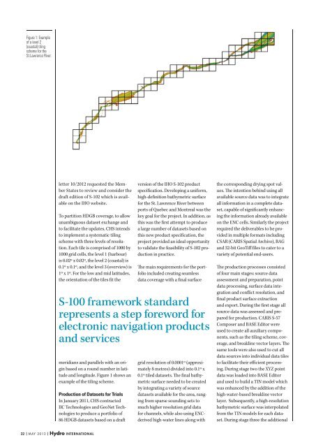
Figure 1: Example<br />
of a level 2<br />
(coastal) tiling<br />
scheme for the<br />
St.Lawrence River.<br />
letter 10/2012 requested the Member<br />
States to review and consider the<br />
draft edition of S-<strong>102</strong> which is available<br />
on the <strong>IHO</strong> website.<br />
To partition HDGB coverage, to allow<br />
unambiguous dataset exchange and<br />
to facilitate the updates, CHS intends<br />
to implement a systematic tiling<br />
scheme with three levels of resolution.<br />
Each tile is comprised of 1000 by<br />
1000 grid cells, the level 1 (harbour)<br />
is 0.02º x 0.02º, the level 2 (coastal) is<br />
0.1º x 0.1º, and the level 3 (overview) is<br />
1º x 1º. For the low and mid latitudes,<br />
the orientation of the tiles fit the<br />
version of the <strong>IHO</strong> S-<strong>102</strong> product<br />
specification. Developing a uniform,<br />
high-definition bathymetric surface<br />
for the St. Lawrence River between<br />
ports of Quebec and Montreal was the<br />
key goal for the project. In addition, as<br />
this was the first attempt to produce<br />
a large number of datasets based on<br />
this new product specification, the<br />
project provided an ideal opportunity<br />
to validate the feasibility of S-<strong>102</strong> production<br />
in practice.<br />
<strong>The</strong> main requirements for the portfolio<br />
included creating seamless<br />
data coverage with a final surface<br />
S-100 framework standard<br />
represents a step foreword for<br />
electronic navigation products<br />
and services<br />
meridians and parallels with an origin<br />
based on a round number in latitude<br />
and longitude. Figure 1 shows an<br />
example of the tiling scheme.<br />
Production of Datasets for Trials<br />
In January 2011, CHS contracted<br />
IIC Technologies and GeoNet Technologies<br />
to produce a portfolio of<br />
86 HDGB datasets based on a draft<br />
grid resolution of 0.0001º (approximately<br />
8 metres) divided into 0.1º x<br />
0.1º tiled datasets. <strong>The</strong> final bathymetric<br />
surface needed to be created<br />
by integrating a variety of source<br />
datasets available for the area, ranging<br />
from sparse sounding sets to<br />
much higher resolution grid data<br />
for channels, while also using ENCderived<br />
high-water lines along with<br />
the corresponding drying spot values.<br />
<strong>The</strong> intention behind using all<br />
available source data was to integrate<br />
all information in a complete dataset,<br />
capable of significantly enhancing<br />
the information already available<br />
on the ENC cells. Similarly the project<br />
required the deliverables to be provided<br />
in multiple formats including<br />
CSAR (CARIS Spatial Archive), BAG<br />
and 32-bit GeoTiff files to cater to a<br />
variety of potential end-users.<br />
<strong>The</strong> production processes consisted<br />
of four main stages: source data<br />
assessment and preparation, point<br />
data processing, surface data integration<br />
and conflict resolution, and<br />
final product surface extraction<br />
and export. During the first stage all<br />
source data was assessed and prepared<br />
for production. CARIS S-57<br />
Composer and BASE Editor were<br />
used to create all auxiliary components,<br />
such as the tiling scheme, coverage,<br />
and breakline vector layers. <strong>The</strong><br />
same tools were also used to cut all<br />
data sources into individual data tiles<br />
to facilitate their efficient processing.<br />
During stage two the XYZ point<br />
data was loaded into BASE Editor<br />
and used to build a TIN model which<br />
was enhanced by the addition of the<br />
high-water-based breakline vector<br />
layer. Subsequently, a high-resolution<br />
bathymetric surface was interpolated<br />
from the TIN models for each dataset.<br />
During stage three the additional<br />
22 | may 2012 | Hydro international


