

Article - The New IHO S-102 Standard - Caris
Article - The New IHO S-102 Standard - Caris
Article - The New IHO S-102 Standard - Caris

Create successful ePaper yourself
Turn your PDF publications into a flip-book with our unique Google optimized e-Paper software.
which will be identified as mandatory,<br />
conditional or optional, will be<br />
selected from these ISO 19115 metadata<br />
packages.<br />
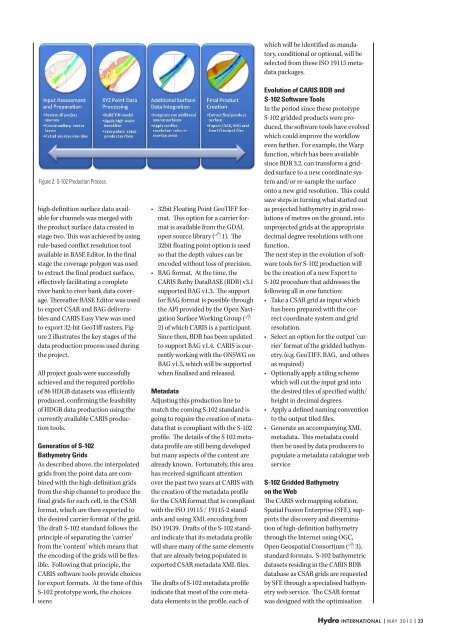
Figure 2: S-<strong>102</strong> Production Process.<br />
high-definition surface data available<br />
for channels was merged with<br />
the product surface data created in<br />
stage two. This was achieved by using<br />
rule-based conflict resolution tool<br />
available in BASE Editor. In the final<br />
stage the coverage polygon was used<br />
to extract the final product surface,<br />
effectively facilitating a complete<br />
river bank to river bank data coverage.<br />
<strong>The</strong>reafter BASE Editor was used<br />
to export CSAR and BAG deliverables<br />
and CARIS Easy View was used<br />
to export 32-bit GeoTiff rasters. Figure<br />
2 illustrates the key stages of the<br />
data production process used during<br />
the project.<br />
All project goals were successfully<br />
achieved and the required portfolio<br />
of 86 HDGB datasets was efficiently<br />
produced, confirming the feasibility<br />
of HDGB data production using the<br />
currently available CARIS production<br />
tools.<br />
Generation of S-<strong>102</strong><br />
Bathymetry Grids<br />
As described above, the interpolated<br />
grids from the point data are combined<br />
with the high-definition grids<br />
from the ship channel to produce the<br />
final grids for each cell, in the CSAR<br />
format, which are then exported to<br />
the desired carrier format of the grid.<br />
<strong>The</strong> draft S-<strong>102</strong> standard follows the<br />
principle of separating the ‘carrier’<br />
from the ‘content’ which means that<br />
the encoding of the grids will be flexible.<br />
Following that principle, the<br />
CARIS software tools provide choices<br />
for export formats. At the time of this<br />
S-<strong>102</strong> prototype work, the choices<br />
were:<br />
• 32bit Floating Point GeoTIFF format.<br />
This option for a carrier format<br />
is available from the GDAL<br />
open source library ( 1). <strong>The</strong><br />
32bit floating point option is used<br />
so that the depth values can be<br />
encoded without loss of precision.<br />
• BAG format. At the time, the<br />
CARIS Bathy DataBASE (BDB) v3.1<br />
supported BAG v1.3. <strong>The</strong> support<br />
for BAG format is possible through<br />
the API provided by the Open Navigation<br />
Surface Working Group (<br />
2) of which CARIS is a participant.<br />
Since then, BDB has been updated<br />
to support BAG v1.4. CARIS is currently<br />
working with the ONSWG on<br />
BAG v1.5, which will be supported<br />
when finalised and released.<br />
Metadata<br />
Adjusting this production line to<br />
match the coming S-<strong>102</strong> standard is<br />
going to require the creation of metadata<br />
that is compliant with the S-<strong>102</strong><br />
profile. <strong>The</strong> details of the S <strong>102</strong> metadata<br />
profile are still being developed<br />
but many aspects of the content are<br />
already known. Fortunately, this area<br />
has received significant attention<br />
over the past two years at CARIS with<br />
the creation of the metadata profile<br />
for the CSAR format that is compliant<br />
with the ISO 19115 / 19115-2 standards<br />
and using XML encoding from<br />
ISO 19139. Drafts of the S-<strong>102</strong> standard<br />
indicate that its metadata profile<br />
will share many of the same elements<br />
that are already being populated in<br />
exported CSAR metadata XML files.<br />
<strong>The</strong> drafts of S-<strong>102</strong> metadata profile<br />
indicate that most of the core metadata<br />
elements in the profile, each of<br />
Evolution of CARIS BDB and<br />
S-<strong>102</strong> Software Tools<br />
In the period since these prototype<br />
S-<strong>102</strong> gridded products were produced,<br />
the software tools have evolved<br />
which could improve the workflow<br />
even further. For example, the Warp<br />
function, which has been available<br />
since BDB 3.2, can transform a gridded<br />
surface to a new coordinate system<br />
and/or re-sample the surface<br />
onto a new grid resolution. This could<br />
save steps in turning what started out<br />
as projected bathymetry in grid resolutions<br />
of metres on the ground, into<br />
unprojected grids at the appropriate<br />
decimal degree resolutions with one<br />
function.<br />
<strong>The</strong> next step in the evolution of software<br />
tools for S-<strong>102</strong> production will<br />
be the creation of a new Export to<br />
S-<strong>102</strong> procedure that addresses the<br />
following all in one function:<br />
• Take a CSAR grid as input which<br />
has been prepared with the correct<br />
coordinate system and grid<br />
resolution.<br />
• Select an option for the output ‘carrier’<br />
format of the gridded bathymetry.<br />
(e.g. GeoTIFF, BAG, and others<br />
as required)<br />
• Optionally apply a tiling scheme<br />
which will cut the input grid into<br />
the desired tiles of specified width/<br />
height in decimal degrees.<br />
• Apply a defined naming convention<br />
to the output tiled files.<br />
• Generate an accompanying XML<br />
metadata. This metadata could<br />
then be used by data producers to<br />
populate a metadata catalogue web<br />
service<br />
S-<strong>102</strong> Gridded Bathymetry<br />
on the Web<br />
<strong>The</strong> CARIS web mapping solution,<br />
Spatial Fusion Enterprise (SFE), supports<br />
the discovery and dissemination<br />
of high-definition bathymetry<br />
through the Internet using OGC,<br />
Open Geospatial Consortium ( 3),<br />
standard formats. S-<strong>102</strong> bathymetric<br />
datasets residing in the CARIS BDB<br />
database as CSAR grids are requested<br />
by SFE through a specialised bathymetry<br />
web service. <strong>The</strong> CSAR format<br />
was designed with the optimisation<br />
Hydro international | may 2012 | 23


