

Article - The New IHO S-102 Standard - Caris
Article - The New IHO S-102 Standard - Caris
Article - The New IHO S-102 Standard - Caris

You also want an ePaper? Increase the reach of your titles
YUMPU automatically turns print PDFs into web optimized ePapers that Google loves.
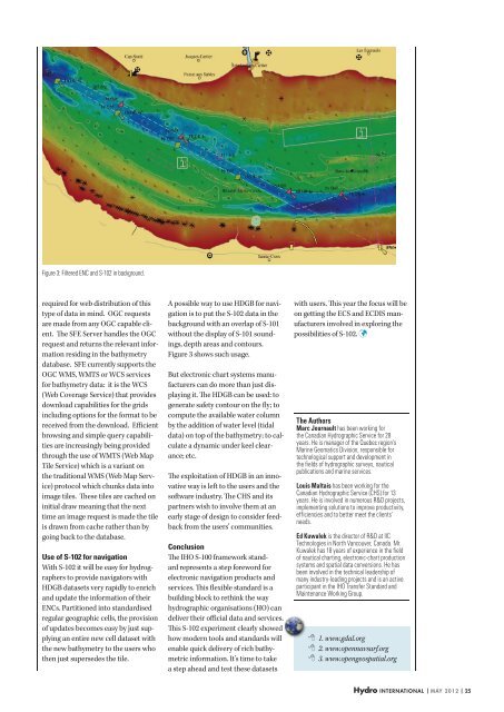
Figure 3: Filtered ENC and S-<strong>102</strong> in background.<br />
required for web distribution of this<br />
type of data in mind. OGC requests<br />
are made from any OGC capable client.<br />
<strong>The</strong> SFE Server handles the OGC<br />
request and returns the relevant information<br />
residing in the bathymetry<br />
database. SFE currently supports the<br />
OGC WMS, WMTS or WCS services<br />
for bathymetry data: it is the WCS<br />
(Web Coverage Service) that provides<br />
download capabilities for the grids<br />
including options for the format to be<br />
received from the download. Efficient<br />
browsing and simple query capabilities<br />
are increasingly being provided<br />
through the use of WMTS (Web Map<br />
Tile Service) which is a variant on<br />
the traditional WMS (Web Map Service)<br />
protocol which chunks data into<br />
image tiles. <strong>The</strong>se tiles are cached on<br />
initial draw meaning that the next<br />
time an image request is made the tile<br />
is drawn from cache rather than by<br />
going back to the database.<br />
Use of S-<strong>102</strong> for navigation<br />
With S-<strong>102</strong> it will be easy for hydrographers<br />
to provide navigators with<br />
HDGB datasets very rapidly to enrich<br />
and update the information of their<br />
ENCs. Partitioned into standardised<br />
regular geographic cells, the provision<br />
of updates becomes easy by just supplying<br />
an entire new cell dataset with<br />
the new bathymetry to the users who<br />
then just supersedes the tile.<br />
A possible way to use HDGB for navigation<br />
is to put the S-<strong>102</strong> data in the<br />
background with an overlap of S-101<br />
without the display of S-101 soundings,<br />
depth areas and contours.<br />
Figure 3 shows such usage.<br />
But electronic chart systems manufacturers<br />
can do more than just displaying<br />
it. <strong>The</strong> HDGB can be used: to<br />
generate safety contour on the fly; to<br />
compute the available water column<br />
by the addition of water level (tidal<br />
data) on top of the bathymetry; to calculate<br />
a dynamic under keel clearance;<br />
etc.<br />
<strong>The</strong> exploitation of HDGB in an innovative<br />
way is left to the users and the<br />
software industry. <strong>The</strong> CHS and its<br />
partners wish to involve them at an<br />
early stage of design to consider feedback<br />
from the users’ communities.<br />
Conclusion<br />
<strong>The</strong> <strong>IHO</strong> S-100 framework standard<br />
represents a step foreword for<br />
electronic navigation products and<br />
services. This flexible standard is a<br />
building block to rethink the way<br />
hydrographic organisations (HO) can<br />
deliver their official data and services.<br />
This S-<strong>102</strong> experiment clearly showed<br />
how modern tools and standards will<br />
enable quick delivery of rich bathymetric<br />
information. It’s time to take<br />
a step ahead and test these datasets<br />
with users. This year the focus will be<br />
on getting the ECS and ECDIS manufacturers<br />
involved in exploring the<br />
possibilities of S-<strong>102</strong>.<br />
<strong>The</strong> Authors<br />
Marc Journault has been working for<br />
the Canadian Hydrographic Service for 28<br />
years. He is manager of the Quebec region’s<br />
Marine Geomatics Division, responsible for<br />
technological support and development in<br />
the fields of hydrographic surveys, nautical<br />
publications and marine services.<br />
Louis Maltais has been working for the<br />
Canadian Hydrographic Service (CHS) for 13<br />
years. He is involved in numerous R&D projects,<br />
implementing solutions to improve productivity,<br />
efficiencies and to better meet the clients’<br />
needs.<br />
Ed Kuwalek is the director of R&D at IIC<br />
Technologies in North Vancouver, Canada. Mr.<br />
Kuwalek has 18 years of experience in the field<br />
of nautical charting, electronic-chart production<br />
systems and spatial data conversions. He has<br />
been involved in the technical leadership of<br />
many industry-leading projects and is an active<br />
participant in the <strong>IHO</strong> Transfer <strong>Standard</strong> and<br />
Maintenance Working Group.<br />
1. www.gdal.org<br />
2. www.opennavsurf.org<br />
3. www.opengeospatial.org<br />
Hydro international | may 2012 | 25


