

Bulletin 23. Potash in the Greensands of NJ, 1923 - State of New ...
Bulletin 23. Potash in the Greensands of NJ, 1923 - State of New ...
Bulletin 23. Potash in the Greensands of NJ, 1923 - State of New ...

Create successful ePaper yourself
Turn your PDF publications into a flip-book with our unique Google optimized e-Paper software.
_4 POTASR IN TIIE GREENSAIVDS OF igEW JEI_]_Y.<br />
W_g_<br />
DATA,<br />
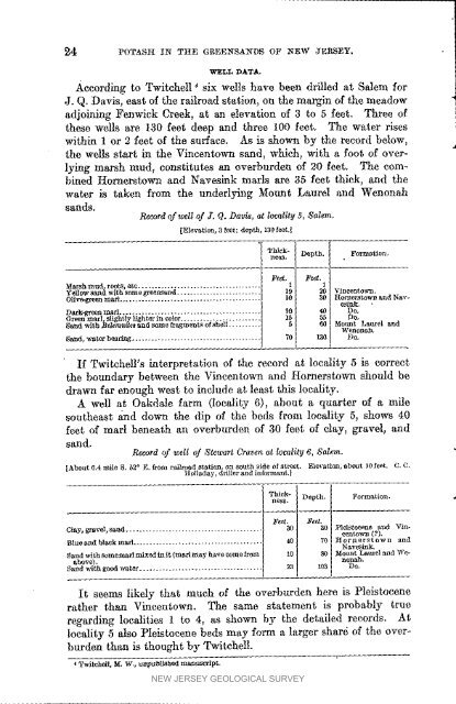
Accord<strong>in</strong>g to Twitehell _ six wells have been drilled at Salem for<br />
J. Q. Davis, east <strong>of</strong> <strong>the</strong> railroad station, on <strong>the</strong> marg<strong>in</strong> <strong>of</strong> <strong>the</strong> meadow I<br />
adjo<strong>in</strong><strong>in</strong>g Fenwick Creek, at an elevation <strong>of</strong> 3 to 5 feet. Three <strong>of</strong><br />
<strong>the</strong>se wells are 130 feet deep and three 100 feet. The water rises<br />
with<strong>in</strong> 1 or 2 feet <strong>of</strong> <strong>the</strong> surface. As is shown by <strong>the</strong> record below,<br />
<strong>the</strong> wells start <strong>in</strong> <strong>the</strong> V<strong>in</strong>centown sand_ which, with a foot <strong>of</strong> overly<strong>in</strong>g<br />
marsh mud, constitutes an overburden <strong>of</strong> 20 feet. The comb<strong>in</strong>ed<br />
Hornerstown and Naves<strong>in</strong>k marls are 35 feet thick, and <strong>the</strong><br />
water is taken from <strong>the</strong> underly<strong>in</strong>g Mount Laurel and Wenonah<br />
sands.<br />
Record <strong>of</strong> well <strong>of</strong> J, Q. Davis, at locality 5, Salem,<br />
[Elevation, 3 feet; depth, 130 feet.]<br />
Formation,<br />
Mal_hlllu(_ root_, e_(l............ I I<br />
19 [ 20 f Vtneentowm<br />
Yellow with _o_tlo grea_nd<br />
10 I 30 I Hona_rstown &lid Nav-<br />
Ollve-g_n marl eslnk. •<br />
Green mar _slightly lighter <strong>in</strong> evlor .... 1 55 Do,<br />
o. oooo.rl °I Oo<br />
Sandwith_elemniCesandsom<strong>of</strong>zagm_ts<strong>of</strong>sh¢ll .......... 60 Mount Laurel and<br />
Wenonal_.<br />
Sand, water bear<strong>in</strong>g 70 I la0 I DO.<br />
If Twitehell's <strong>in</strong>terpretation <strong>of</strong> <strong>the</strong> record at loeMity 5 is correct<br />
<strong>the</strong> boundary between <strong>the</strong> V<strong>in</strong>centown and Hornerstown should be<br />
drawn far enough west to <strong>in</strong>clude at least this locality.<br />
A well at Oakdale farm (locality 6), about a quarter <strong>of</strong> a mile<br />
sou<strong>the</strong>ast and down <strong>the</strong> dip <strong>of</strong> <strong>the</strong> beds from locality 5, shows 40<br />
feet <strong>of</strong> marl beneath an overburden <strong>of</strong> 30 feet <strong>of</strong> clay, gravel, and<br />
sand.<br />
Record<strong>of</strong> well <strong>of</strong> StewartCravenat locality6, Salem.<br />
[About 0.4 mile 8. 52 _ E. from railroad station, on south side <strong>of</strong> street. Elevation, _bout 10 feet. C, C,<br />
H olladay, driller and/_1ormant.]<br />
Thick- Depth. Formation.<br />
ne_.<br />
Feet. J_eet.<br />
30 Pleisto_ne and Y<strong>in</strong>-<br />
Clay, gravel, sand .......................................... 20 cent ovra (?),<br />
Blueaadbte_kmarl ........................................ 0 76 Hornarstown and<br />
Nav_s<strong>in</strong>_<br />
Sa_d with somemarl mixed <strong>in</strong> it (marlmay have come from 10 80 :_otmt Laurel and "W_<br />
above),<br />
nonah.<br />
Sa_d _th good water ..................................... 23 103 Do.<br />
It seems likely that much <strong>of</strong> <strong>the</strong> overburden here is Pleistocene<br />
ra<strong>the</strong>r than V<strong>in</strong>centown. The same statement is probably true<br />
regard<strong>in</strong>g localities 1 to 4, as shown by <strong>the</strong> detailed records. At<br />
locality 5 also Pleistocene beds may form a larger shard <strong>of</strong> <strong>the</strong> overburden<br />
than is thought by Twitchell.<br />
Twitchsll, _. W., _t_pubE_hed manuscript,<br />
NEW JERSEY GEOLOGICAL SURVEY


