

Bulletin 23. Potash in the Greensands of NJ, 1923 - State of New ...
Bulletin 23. Potash in the Greensands of NJ, 1923 - State of New ...
Bulletin 23. Potash in the Greensands of NJ, 1923 - State of New ...

Create successful ePaper yourself
Turn your PDF publications into a flip-book with our unique Google optimized e-Paper software.
36 POTAS_ I_ THE GREEIVSANDS OF NEW JERSEY.<br />
<strong>of</strong> <strong>the</strong> <strong>State</strong> Survey, will be <strong>of</strong> <strong>in</strong>terest to any company that proposes<br />
commercial development <strong>of</strong> <strong>the</strong> greensands:<br />
The town supply <strong>of</strong> Woodstown, Salem County, is drawn <strong>in</strong> part from six wells<br />
near <strong>the</strong> bank <strong>of</strong> <strong>the</strong> creek at an elevation <strong>of</strong> about 20 feet _nd vary<strong>in</strong>g from 136 to<br />
149 feet <strong>in</strong> depth. The average flow <strong>of</strong> each well from <strong>the</strong> top <strong>of</strong> <strong>the</strong> cas<strong>in</strong>g, 1 foot abox e<br />
<strong>the</strong> surface, is about 60 gallons per m<strong>in</strong>ute; temperature 58 °. The wells draw from<br />
<strong>the</strong> Mount Laurel-Wenonah sands, which were water-bear<strong>in</strong>g h'om 60 to H_ feet<br />
below sea level. A seventh well at this po<strong>in</strong>t was prospected to 776 feet. Waterbearlilg<br />
sands were found at <strong>the</strong> top <strong>of</strong> <strong>the</strong> Magothy-Raritan formation from 27G to 319<br />
feet below sea level and also near <strong>the</strong> bottom <strong>of</strong> <strong>the</strong> series at 756 feet below sea le_ el.<br />
Between <strong>the</strong>se two horizons an alternat<strong>in</strong>g series <strong>of</strong> sands and white and red clays<br />
was found, all <strong>of</strong> which apparently belong to <strong>the</strong> Raritan and Magothy formations,<br />
which here have a thickness <strong>of</strong> ,180 feet, _vfith base not reached. The water at 2_6<br />
feet (276 feet below sea level_ rose with<strong>in</strong> 14 feet <strong>of</strong> <strong>the</strong> surface, and that from 776<br />
feet (756 feet below sea levell with<strong>in</strong> 18 feet. In 1915 a new well was driven to a depth<br />
<strong>of</strong> 3,t0 feet, which drew upon <strong>the</strong> upper horizon <strong>in</strong> <strong>the</strong> Magothy-Raritan at 310 feet.<br />
The yieht <strong>of</strong> this deep well on pump<strong>in</strong>g is 300 gallons per m<strong>in</strong>ute, and it has <strong>the</strong>refore<br />
proved an important addition to <strong>the</strong> town supply.<br />
Available records <strong>of</strong> <strong>the</strong> 340-foot well diffcr somewhat, but <strong>the</strong> follow<strong>in</strong>g,<br />
taken from a letter <strong>in</strong> <strong>the</strong> files <strong>of</strong> <strong>the</strong> <strong>State</strong> Geological Survev,<br />
cheeks fairly well with <strong>the</strong> samples now preserved at <strong>the</strong> pump<strong>in</strong>g<br />
station and k<strong>in</strong>dly shown to <strong>the</strong> writer by Mr. Oren Conover, city<br />
eng<strong>in</strong>eer.<br />
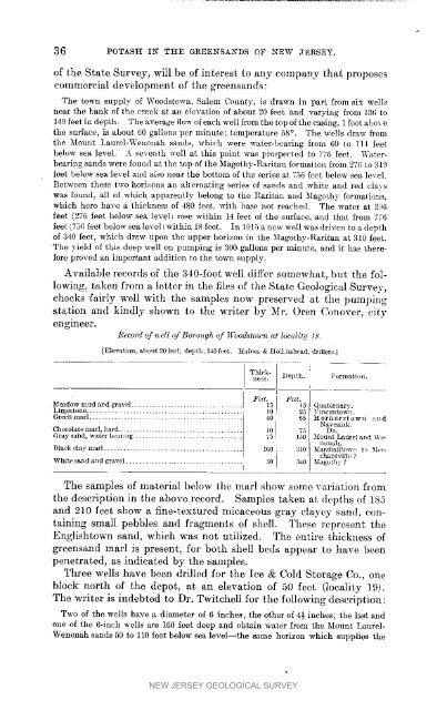
Record <strong>of</strong> _zell <strong>of</strong> Boro_lgh <strong>of</strong> ll'ood, stou_ at loclilit!/ 18.<br />
[Elevati_n, about 20 feet; depth, 340 feet. HlLhi_ & Ilolli_tshvad, drillers.}<br />
Thick- Depth. Formati(m.<br />
/less.<br />
1<br />
Meadow mud and gravel ..........................<br />
Quaternary.<br />
Limestone ................................<br />
Green marl ................................. 40<br />
25<br />
65<br />
Villeellto'_;ll.<br />
_[ornerst owil _llld<br />
Chocolate<br />
Gray sal]d, marl, wa cr hard be.r ............................ ng ................... I0 I<br />
_5 75 Navcs<strong>in</strong>k.<br />
1,50 Mount Do.<br />
Laurel and W_<br />
ilOll_h.<br />
Black elaymarl .............. 160 , 310 Marshalltown to M_,rchaiit<br />
viIh_ ?<br />
White sarld and gravel .............................. 30 ] 3441 Magolh_ ?<br />
The samples <strong>of</strong> material below <strong>the</strong> marl show some variation from<br />
<strong>the</strong> description <strong>in</strong> <strong>the</strong> above record. Samples taken at depths <strong>of</strong> 185<br />
and 210 feet show a f<strong>in</strong>e-textured micaceous gray clayey sand, conta<strong>in</strong><strong>in</strong>g<br />
small pebbles and fragments <strong>of</strong> shell. These represent <strong>the</strong><br />
Englishtown sand, which was not utilized. The entire thickness <strong>of</strong><br />
greensand marl is present, for both shell beds appear to have been<br />
penetrated, as <strong>in</strong>dicated by <strong>the</strong> samples.<br />
2'ln'ee wells have been drilled for <strong>the</strong> Ice & Cold Storage Co., one<br />
block north <strong>of</strong> <strong>the</strong> depot, at an elevation <strong>of</strong> 50 feet (locality 19).<br />
The writer is <strong>in</strong>debted to Dr. Twitchell for <strong>the</strong> follow<strong>in</strong>g description:<br />
Two <strong>of</strong> <strong>the</strong> wells have a diameter <strong>of</strong> 6 <strong>in</strong>ches, <strong>the</strong> o<strong>the</strong>r <strong>of</strong> 4½ <strong>in</strong>ches; <strong>the</strong> last and<br />
one <strong>of</strong> <strong>the</strong> 6-<strong>in</strong>ch wells are 160 feet deep and obta<strong>in</strong> water from <strong>the</strong> Mount Laurel-<br />
Wenonah sands 50 to 110 feet below sea level--<strong>the</strong> same horizon which supplies <strong>the</strong><br />
NEW JERSEY GEOLOGICAL SURVEY


