Checklist - City of Centralia, WA
Checklist - City of Centralia, WA
Checklist - City of Centralia, WA

You also want an ePaper? Increase the reach of your titles
YUMPU automatically turns print PDFs into web optimized ePapers that Google loves.
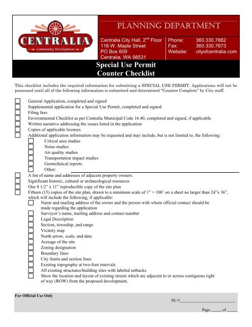
PLANNING DEPARTMENT<br />
<strong>Centralia</strong> <strong>City</strong> Hall, 2 nd Floor<br />
118 W. Maple Street<br />
PO Box 609<br />
<strong>Centralia</strong>, <strong>WA</strong> 98531<br />
Special Use Permit<br />
Counter <strong>Checklist</strong><br />
Phone:<br />
Fax:<br />
Website:<br />
360.330.7662<br />
360.330.7673<br />
city<strong>of</strong>centralia.com<br />
This checklist includes the required information for submitting a SPECIAL USE PERMIT. Applications will not be<br />
processed until all <strong>of</strong> the following information is submitted and determined “Counter Complete” by <strong>City</strong> staff.<br />
General Application, completed and signed<br />
Supplemental application for a Special Use Permit, completed and signed<br />
Filing fees<br />
Environmental <strong>Checklist</strong> as per <strong>Centralia</strong> Municipal Code 16.40, completed and signed, if applicable<br />
Written narrative addressing the issues listed in the application<br />
Copies <strong>of</strong> applicable licenses<br />
Additional application information may be requested and may include, but is not limited to, the following:<br />
Critical area studies<br />
Noise studies<br />
Air quality studies<br />
Transportation impact studies<br />
Geotechnical reports<br />
Other:<br />
A list <strong>of</strong> name and addresses <strong>of</strong> adjacent property owners.<br />
Significant historic, cultural or archaeological resources<br />
One 8 1/2” x 11” reproducible copy <strong>of</strong> the site plan<br />
Fifteen (15) copies <strong>of</strong> the site plan, drawn to a minimum scale <strong>of</strong> 1” = 100’ on a sheet no larger than 24”x 36”,<br />
which will include the following, if applicable:<br />
Name and mailing address <strong>of</strong> the owner and the person with whom <strong>of</strong>ficial contact should be<br />
made regarding the application<br />
Surveyor’s name, mailing address and contact number<br />
Legal Description<br />
Section, township, and range<br />
Vicinity map<br />
North arrow, scale, and date<br />
Acreage <strong>of</strong> the site<br />
Zoning designation<br />
Boundary lines<br />
<strong>City</strong> limits and section lines<br />
Existing topography at two-foot intervals<br />
All existing structures/building sites with labeled setbacks<br />
Show the location and layout <strong>of</strong> existing streets which are adjacent to or across contiguous right<br />
<strong>of</strong> way (ROW) from the proposed development.<br />
For Official Use Only<br />
SU #___________________________<br />
Page _____ <strong>of</strong> _____
Identify the following uses.<br />
Buildings<br />
Wells<br />
Well head protection areas<br />
Sewage disposal systems<br />
Water courses<br />
Bodies <strong>of</strong> water, including wetlands<br />
Flood zones<br />
Culverts<br />
Bridges<br />
Structures<br />
Overhead and underground utilities<br />
Railroad Lines<br />
Other features existing upon, over or under the land, identifying any which are to<br />
be retained or removed.<br />
All critical areas<br />
Location and width <strong>of</strong>, but not limited to, the following types <strong>of</strong> access:<br />
Streets<br />
Alleys<br />
Right <strong>of</strong> Way’s<br />
For Official Use Only<br />
SU #___________________________<br />
Page _____ <strong>of</strong> _____