Barnstable County High Crash Locations - Cape Cod Commission
Barnstable County High Crash Locations - Cape Cod Commission
Barnstable County High Crash Locations - Cape Cod Commission

You also want an ePaper? Increase the reach of your titles
YUMPU automatically turns print PDFs into web optimized ePapers that Google loves.
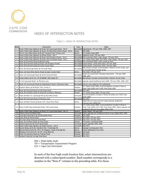
INDEX OF INTERSECTION NOTES<br />
TABLE 1: INDEX OF INTERSECTION NOTES<br />
Note Intersection Town Notes<br />
1 Route 6 (Mid-<strong>Cape</strong> <strong>High</strong>way) @ Route 132 (Iyannough Road) - Exit 6 <strong>Barnstable</strong> Signalization; TIP year 2005, 2006, 2007<br />
2 Route 6 (Mid-<strong>Cape</strong> <strong>High</strong>way) @ Route 134 (East West Dennis Road) - Exit 9 Dennis RSA 2009<br />
3 Otis Air Force Base Rotary @ Rt 28 / Sandwich Rd / Connery Ave Bourne CCC Safety Study 2006<br />
4 Route 6 (Mid-<strong>Cape</strong> <strong>High</strong>way) @ Willow Street - Exit 7 Yarmouth Additional lanes; TIP year 2004<br />
5 Route 6 (Mid-<strong>Cape</strong> <strong>High</strong>way) @ Route 149 (Prospect Street) - Exit 5 <strong>Barnstable</strong> RSA conducted 2010; under design, TIP year 2010<br />
6 Route 6 (Mid-<strong>Cape</strong> <strong>High</strong>way) @ Route 130 (Forestdale Road) - Exit 2 Sandwich CCC Safety Study 2008; RSA 2009; under design; TIP year 2010<br />
7 Route 28 (Falmouth Road) @ Bearses Way <strong>Barnstable</strong> RSA conducted 2009; under review by town<br />
8 Route 28 (Falmouth Road) @ Route 149 (Prospect Street) <strong>Barnstable</strong> Signal design; construction 2010; TIP year 2009<br />
10 Route 28 (Falmouth Road) @ South <strong>County</strong> Road <strong>Barnstable</strong> Signal design; construction 2010; TIP year 2009<br />
11 Route 28 (Iyannough Road) @ Yarmouth Road<br />
New design concepts recommended in Hyannis Access Study; part<br />
<strong>Barnstable</strong><br />
of Yarmouth Road Corridor Study<br />
12 Route 134 (East West Dennis Road) @ Upper <strong>County</strong> Road Dennis RSA 2010; TIP year 2012<br />
14 Route 132 (Iyannough Road) @ Shoot Flying Hill Road<br />
Route 132 construction relocated intersection - TIP year 2005,<br />
<strong>Barnstable</strong><br />
2006, 2007<br />
15 Airport Rotary @ Rt 132 / Rt 28 EB/WB / <strong>Barnstable</strong> Rd <strong>Barnstable</strong> New design concepts recommended in Hyannis Access Study<br />
16 Rt 132 (Iyanough Road) @ Phinneys Lane <strong>Barnstable</strong> Upgrade signals/additional lanes 2009; TIP year 2005, 2006, 2007<br />
17 Route 132 (Iyannough Road) @ Independence Road / Enterprise Road <strong>Barnstable</strong> Left turn lane added to 132 southbound<br />
18 Eastham Rotary @ Rt 6A/28 / Rt 6, Smith Ln Eastham<br />
CCC Safety Study 2009; recommendations included in Route 6<br />
Outer <strong>Cape</strong> Safety and Traffic Flow Study 2004<br />
19 Route 28 (Falmouth Road) @ Old Stage Road <strong>Barnstable</strong> RSA 2007<br />
20 Route 28 (Chatham Road) @ Route 6A (Cranberry <strong>High</strong>way) Orleans CCC Safety Study 2006; TIP year 2012<br />
21 Route 28 (Main St / Iyannough Rd) @ East Main Street Yarmouth<br />
Recommendations included in Route 28 Safety and Traffic Flow<br />
Study 2006<br />
22 Route 28 (Falmouth Road) @ Phinneys Lane <strong>Barnstable</strong> RSA 2007<br />
23 Route 28 (Main Street) @ Route 134 / Swan River Road Dennis<br />
Added left turn lanes and new signal phasing, pedestrian<br />
improvements 2009/2010<br />
24 Route 6 (GAR Hwy) @ Brackett Road / Old <strong>County</strong> Road Eastham<br />
CCC Safety Study 2008; recommendations included in Route 6<br />
Outer <strong>Cape</strong> Safety and Traffic Flow Study 2004; Signal upgrade and<br />
westbound left-turn lane added 2009, 2010<br />
25 Route 6 (Mid-<strong>Cape</strong> <strong>High</strong>way) @ Route 137 (Long Pond Road) - Exit 11 Harwich Under design; TIP year 2011<br />
26 Station Avenue @ Whites Path Yarmouth Signal upgrade and northbound left-turn lane added 2003, 2004<br />
27 Great Neck Road North @ Old <strong>Barnstable</strong> Road Mashpee RSA 2009<br />
28 Cotuit Road @ Harlow Road Sandwich RSA 2009; TIP year 2011<br />
29 Old Town House Road @ Forest Road Yarmouth RSA 2010; TIP year 2010<br />
30 Route 28 (Chatham Road) @ Finlay Road Orleans TIP project, advertised 2006<br />
31 Station Avenue @ Old Town House Road Yarmouth Signal upgrades 2003, 2004<br />
32 Route 6 (Mid-<strong>Cape</strong> <strong>High</strong>way) @ Station Avenue - Exit 8 Yarmouth RSA 2011<br />
33 Bourne Rotary @ Rt 28 / Sandwich Rd / Trowbridge Rd Bourne Signage & striping plan 2011<br />
34 Belmont Rotary @ Rt 28 / Rt 6 / Rt 6 Bypass / Head of the Bay Rd Bourne Project Notification Form 2011<br />
35 Mashpee Circle @ Rt 28 / Rt 151 / Great Neck Rd Mashpee VAI Study<br />
36 Route 124 (Harwich Road) @ Tubman Road Brewster RSA 2011<br />
37 Sandwich Road @ Carriage Shop Road Falmouth RSA 2011<br />
RSA = Road Safety Audit<br />
TIP = Transportation Improvement Program<br />
CCC = <strong>Cape</strong> <strong>Cod</strong> <strong>Commission</strong><br />
In each of the four high crash location lists, select intersections are<br />
denoted with a subscripted number. Each number corresponds to a<br />
number in the “Note #” column in the preceding table. For those<br />
Page 16<br />
<strong>Barnstable</strong> <strong>County</strong> <strong>High</strong> <strong>Crash</strong> <strong>Locations</strong>