PDF (53.8 MB) - Urban Drainage and Flood Control District
PDF (53.8 MB) - Urban Drainage and Flood Control District
PDF (53.8 MB) - Urban Drainage and Flood Control District
You also want an ePaper? Increase the reach of your titles
YUMPU automatically turns print PDFs into web optimized ePapers that Google loves.
Muller Engineering Company, Inc.<br />
Happy Canyon Creek Major <strong>Drainage</strong>way Plan - DRAFT<br />
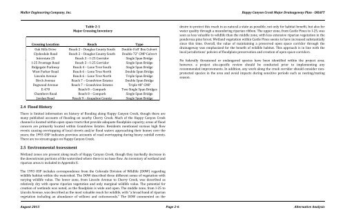
Table 2-1<br />
Major Crossing Inventory<br />
Crossing Location Reach Type<br />
Oak Hills Drive Reach 2 – Douglas County South Double 6’x8’ Box Culvert<br />
Clydesdale Road Reach 2 – Douglas County South Double 72” CMP Culvert<br />
Interstate 25 Reach 3 – I-25 Corridor Single Span Bridge<br />
I-25 Frontage Road Reach 3 – I-25 Corridor Single Span Bridge<br />
Ridgegate Parkway Reach 4 – Lone Tree South Single Span Bridge<br />
West Parker Road Reach 6 – Lone Tree North Double Span Bridge<br />
Lincoln Avenue Reach 6 – Lone Tree North Triple Span Bridge<br />
Birch Avenue Reach 7 – Gr<strong>and</strong>view Estates Double Span Bridge<br />
Dogwood Avenue Reach 7 – Gr<strong>and</strong>view Estates Triple 48” CMP<br />
E-470 Reach 8 – Compark Two Single Span Bridges<br />
Chambers Road Reach 8 – Compark Single Span Bridge<br />
Jordan Road Reach 9 – Arapahoe County Single Span Bridge<br />
desire to protect this reach in as natural a state as possible, not only for habitat benefit, but also for<br />
water quality through a me<strong>and</strong>ering riparian ribbon. The upper zone, from Castle Pines to I-25, was<br />
seen as less valuable to wildlife than the middle zone, with less extensive riparian vegetation in the<br />
ponderosa pine forest. Wetl<strong>and</strong> vegetation within Castle Pines seems to have increased substantially<br />
since this time. Overall, the value of maintaining a preserved open space corridor through the<br />
drainageway was emphasized for the benefit of wildlife habitat. This approach is in line with the<br />
local jurisdictions’ policies of floodplain preservation <strong>and</strong> creation of open space corridors.<br />
No federally threatened or endangered species have been identified within the project area;<br />
however, a project site-specific review should be conducted prior to implementing any<br />
recommended improvements. In addition, any work along the creek corridor should consider nonprotected<br />
species in the area <strong>and</strong> avoid impacts during sensitive periods such as nesting/mating<br />
season.<br />
2.4 <strong>Flood</strong> History<br />
There is limited information on history of flooding along Happy Canyon Creek, though there are<br />
many published accounts of flooding on nearby Cherry Creek. Much of the Happy Canyon Creek<br />
channel is located within open space tracts that provide adequate floodplain capacity; areas of flood<br />
concern are primarily located within Gr<strong>and</strong>view Estates. Residents mentioned various high flow<br />
events causing overtopping of local streets <strong>and</strong>/or flood waters approaching their homes over the<br />
years; the 1993 OSP indicates previous accounts of road overtopping during heavy rainfall events.<br />
There are no stream gages on Happy Canyon Creek.<br />
2.5 Environmental Assessment<br />
Wetl<strong>and</strong> zones are present along much of Happy Canyon Creek, though they markedly decrease in<br />
the downstream portions of the watershed where there is no base flow. An inventory of wetl<strong>and</strong> <strong>and</strong><br />
riparian areas is included in Appendix E.<br />
The 1993 OSP includes correspondence from the Colorado Division of Wildlife (DOW) regarding<br />
wildlife habitat within the watershed. The DOW described three different zones of vegetation with<br />
varying wildlife value. The lower zone, from Lincoln Avenue to Cherry Creek, was described as<br />
relatively dry with sparse riparian vegetation <strong>and</strong> only marginal wildlife value. The potential for<br />
creation of wetl<strong>and</strong>s was noted, as the floodplain is wide <strong>and</strong> open. The middle zone, from I-25 to<br />
Lincoln Avenue, was described as the most valuable reach for wildlife, with “a broad b<strong>and</strong> of riparian<br />
vegetation including an abundance of willows <strong>and</strong> cottonwoods.” The DOW commented on the<br />
August 2013 Page 2-6 Alternative Analysis


