PDF (53.8 MB) - Urban Drainage and Flood Control District
PDF (53.8 MB) - Urban Drainage and Flood Control District
PDF (53.8 MB) - Urban Drainage and Flood Control District

Create successful ePaper yourself
Turn your PDF publications into a flip-book with our unique Google optimized e-Paper software.
Muller Engineering Company, Inc.<br />
Happy Canyon Creek Major <strong>Drainage</strong>way Plan - DRAFT<br />
Reach 3, located adjacent to I-25, is another severely degraded reach. Though the floodplain width<br />
through this reach has always been limited due to the steep topography, construction of I-25 further<br />
constricted the Happy Canyon Creek floodplain <strong>and</strong> reduced the stream length by eliminating<br />
me<strong>and</strong>ers in the channel. The constricted floodplain combined with increased flow rates from<br />
upstream development <strong>and</strong> from I-25 itself have led to channel instability in this reach, with the<br />
potential to threaten the integrity of I-25. There are numerous instances of slope paving failure, <strong>and</strong><br />
a sheet pile failure where the Oak Ridge tributary crosses below the interstate. Ongoing bank scour<br />
is evident through recent bank collapses. Happy Canyon makes a 90-degree turn to cross under the<br />
I-25 bridge; the channel invert has scoured several feet along the north (outer) side of the bridge<br />
crossing, potentially threatening the bridge abutment.<br />
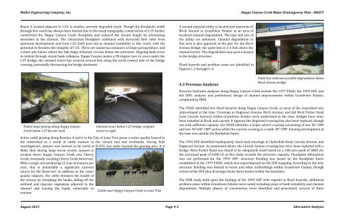
A second exposed utility is located just upstream of<br />
Birch Avenue in Gr<strong>and</strong>view Estates in an area of<br />
localized channel degradation. The type <strong>and</strong> size of<br />
the utility are unknown. Channel degradation in<br />
this area is also apparent at the pier for the Birch<br />
Avenue bridge; the paint line is 2-3 feet above the<br />
channel invert. This degradation may pose a hazard<br />
to the bridge structure.<br />
<strong>Flood</strong> hazards <strong>and</strong> problem areas are identified in<br />
Figures C-2 through C-4.<br />
4.3 Previous Analyses<br />
Paint line indicates possible degradation below<br />
Birch Avenue bridge<br />
Previous hydraulic analyses along Happy Canyon Creek include the 1977 FHAD, the 1993 OSP, <strong>and</strong><br />
the 2001 analysis <strong>and</strong> preliminary design of channel improvements within Gr<strong>and</strong>view Estates,<br />
completed by HDR.<br />
Failed slope paving along Happy Canyon<br />
Creek below I-25 barrier wall.<br />
Channel scour below I-25 bridge; original<br />
invert to right<br />
Active cattle grazing along Reaches 4 <strong>and</strong> 6 in the City of Lone Tree poses a water quality hazard to<br />
the watershed as a result of cattle manure in the stream bed <strong>and</strong> overbanks. During field<br />
investigations, manure was noticed as far north as E-470, two miles beyond the grazing area. It is<br />
likely that, during large storm events, manure is<br />
washed down Happy Canyon Creek into Cherry<br />
Creek, eventually reaching Cherry Creek Reservoir.<br />
With a single cow producing 12 tons of manure per<br />
year, this is potentially a significant nutrient<br />
source for the Reservoir. In addition to the water<br />
quality impacts, the cattle threaten the health of<br />
the stream by trampling the banks, killing off the<br />
wetl<strong>and</strong> <strong>and</strong> riparian vegetation adjacent to the<br />
channel <strong>and</strong> leaving the banks vulnerable to<br />
Cattle near Happy Canyon Creek in Lone Tree<br />
erosion.<br />
The FHAD identified few flood hazards along Happy Canyon Creek, as most of the watershed was<br />
undeveloped at the time. Crossings at Dogwood Avenue, Birch Avenue, <strong>and</strong> old West Parker Road<br />
(now Lincoln Avenue) within Gr<strong>and</strong>view Estates were undersized at the time; bridges have since<br />
been installed at Birch <strong>and</strong> Lincoln. It appears the Dogwood crossing has also been replaced, though<br />
not with sufficient capacity; the FHAD identifies a triple culvert crossing consisiting of one 36” CMP<br />
<strong>and</strong> two 36”x60” CMP arches while the current crossing is a triple 48” CMP. Existing development at<br />
the time was outside the floodplain limits.<br />
The 1993 OSP identified inadequately sized road crossings at Clydesdale Road, Lincoln Avenue, <strong>and</strong><br />
Dogwood Avenue. As mentioned above, the Lincoln Avenue crossing has since been replaced with a<br />
bridge. West Parker Road was found to be adequately sized based on a 100-year peak of 3800 cfs;<br />
the increased peak of 6200 cfs in this study exceeds the structure capacity. <strong>Flood</strong>plain delineation<br />
was not performed for the 1993 OSP; structure flooding was based on the floodplain limits<br />
established in the 1977 FHAD, which was superimposed on the OSP mapping. According to the text,<br />
structure flooding was limited to barns <strong>and</strong> other outbuildings within Gr<strong>and</strong>view Estates, though<br />
review of the OSP plan drawings shows three homes within the boundary.<br />
The HDR study built upon the findings of the 1993 OSP with regards to flood hazards; additional<br />
problem areas within Gr<strong>and</strong>view Estates were noted including areas of bank instability <strong>and</strong> channel<br />
degradation. Multiple phases of construction were identified <strong>and</strong> prioritized; several of these<br />
August 2013 Page 4-5 Alternative Analysis