PDF (53.8 MB) - Urban Drainage and Flood Control District
PDF (53.8 MB) - Urban Drainage and Flood Control District
PDF (53.8 MB) - Urban Drainage and Flood Control District

You also want an ePaper? Increase the reach of your titles
YUMPU automatically turns print PDFs into web optimized ePapers that Google loves.
MEETING<br />
MEMORANDUM<br />
Project<br />
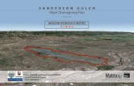
Happy Canyon Creek MDP & FHAD<br />
Sponsors<br />
UDFCD / Douglas County / City of Lone Tree /<br />
Town of Parker / SEMSWA<br />
Meeting Location<br />
SEMSWA<br />
Attendees<br />
See attached list<br />
MULLER ENGINEERING COMPANY, INC.<br />
CONSULTING ENGINEERS<br />
777 SOUTH WADSWORTH BLVD., SUITE 4-100<br />
LAKEWOOD, COLORADO 80226<br />
(303) 988-4939<br />
Meeting Date<br />
September 10, 2012<br />
Issue Date<br />
October 3, 2012<br />
MEC Project No.<br />
12-010.01<br />
Minutes Prepared By<br />
Andy Pultorak, Melanie Chenard<br />
Routing<br />
ASP / MDC / JTW<br />
Purpose<br />
Happy Canyon Creek MDP & FHAD Progress Meeting #3<br />
Action Items<br />
Muller Action Items:<br />
1. Muller will address sponsor comments on the Baseline Hydrology <strong>and</strong> post the updated report to Dropbox<br />
for sponsor review.<br />
2. Melanie will send a meeting invite for Progress Meeting #4 to all sponsors <strong>and</strong> stakeholders.<br />
3. Andy will provide Stacey Thompson with a figure showing the draft floodplain delineation near the water<br />
treatment facility south of Jordan Rd. on the Happy Canyon mainstem.<br />
4. Melanie will review the draft Rock Creek MDP for guidance on interactive hydrologic maps.<br />
5. Muller will contact additional stakeholders identified by the project sponsors.<br />
6. Muller will coordinate with Brad Robenstein (Douglas County) to obtain grading plan / LOMR<br />
information at the north end of Chambers Reservoir <strong>and</strong> to determine the construction time frame of<br />
Meridian Ponds 4A-4C.<br />
UDFCD Action Items:<br />
1. Shea will provide Muller with the updated UDFCD DFHAD Guidelines <strong>and</strong> checklist.<br />
2. Shea will review the new UDFCD rainfall data (as posted on the UDFCD website) <strong>and</strong> determine if there<br />
is any impact to the Happy Canyon hydrology.<br />
3. Shea will discuss the following items with Bill DeGroot <strong>and</strong> instruct Muller accordingly:<br />
a. What starting WSEL should be used at Cherry Creek for 10, 50, <strong>and</strong> 500-year Happy Canyon<br />
Creek FP?<br />
b. What flowrate/WSEL should be assumed in Green Acres Trib. if the mainstem spills into it in a<br />
100- or 500-year?<br />
c. What steps should be taken (if any) at locations where the me<strong>and</strong>er of the low-flow channel does<br />
not match the floodplain centerline?<br />
d. Where flow spills from the main channel into a side channel, should the spill flow be subtracted<br />
from the main channel if the spill is significant?<br />
e. Should Muller model the proposed channel improvements at I-25 for the Douglas County East-<br />
West trail if construction is not expected until late in 2013?<br />
Happy Canyon Creek MDP & FHAD – Progress Meeting #3 – Meeting Minutes<br />
September 10, 2012<br />
4. UDFCD will review the draft mainstem cross-section locations workmaps provided by Muller <strong>and</strong> provide<br />
any comments.<br />
5. UDFCD will provide LiDAR mapping for Badger Gulch to Muller once data processing is finished.<br />
Discussion<br />
THE FOLLOWING IS OUR UNDERSTANDING OF THE SUBJECT MATTER COVERED IN THIS<br />
CONFERENCE. IF THIS DIFFERS WITH YOUR UNDERSTANDING, PLEASE NOTIFY US.<br />
1. INTRODUCTIONS<br />
2. DRAFT BASELINE HYDROLOGY COMMENTS<br />
The group discussed the overall results of the baseline hydrology <strong>and</strong> the calibration effort. The initial<br />
results indicated significantly higher peak flows than the 1993 OSP though the 1993 % impervious was<br />
matched <strong>and</strong> the subwatershed <strong>and</strong> conveyance element parameters were very similar to the 1993 model.<br />
Because the Happy Canyon Creek watershed is adjacent to the Cottonwood Creek watershed <strong>and</strong> should<br />
exhibit similar flow characteristics, the results were compared with the 2010 Cottonwood Creek OSP<br />
hydrology based on pre-development conditions on both watersheds. Ultimately, the Happy Canyon Creek<br />
model was calibrated to match Cottonwood Creek peak flows by adjusting Cp values (see the report for<br />
additional discussion). The resultant peak flows, prior to updates for existing <strong>and</strong> revised future conditions,<br />
still exceed the 1993 OSP but compare favorably with the 1977 FHAD, which are the regulatory flow<br />
rates. Muller will add the FHAD peak flow rates to Figure B-10 in the report <strong>and</strong> will provide some<br />
additional discussion of the differences in hydrology between this master plan <strong>and</strong> the 1977 FHAD.<br />
Bill Ruzzo inquired if the hydrology would be revisited if the increased peak flow rates have detrimental<br />
floodplain impacts. Shea indicated that this is a possibility.<br />
Additional discussion of specific comments is summarized below.<br />
a. SEMSWA has new aerial photography dated Spring 2012. Because the coverage is limited to<br />
Arapahoe County <strong>and</strong> changes in this portion of the watershed are limited, the 2010 aerial<br />
photography provided by UDFCD will continue to be used for the project.<br />
b. Greg Weeks provided Muller with a conceptual alignment for the future Belford Ave. bridge crossing<br />
over Happy Canyon Creek south of E-470. The area to the east of Happy Canyon, north of Gr<strong>and</strong>view<br />
Estates, is another Town of Parker annexation area (Chambers High Point) – information is available<br />
on the Town’s website.<br />
c. In response to some SEMSWA comments, Muller clarified the peak flow rates at the confluence with<br />
Cherry Creek:<br />
• Arapahoe County FIS published 100-year peak = 3690 cfs for Happy Canyon Creek. The source<br />
of this flow rate is unknown; it does not match any known studies.<br />
• Mapped floodplain appears to be based on the 1993 OSP 100-year future conditions peak of 7303<br />
cfs rather than the FIS published value.<br />
• 1977 FHAD (future conditions) = 6744 cfs<br />
• Current study (future conditions) = 9238 cfs<br />
The discrepancies seem to be limited to the Arapahoe County portion of the channel; the remainder of<br />
the floodplain appears to be based on the 1977 FHAD hydrology.<br />
d. Lone Tree had commented on modeling of piped reaches in SWMM model. The report stated that the<br />
pipe sizes had been artificially enlarged in the SWMM model to convey the entire peak flow, since<br />
overtopping a piped reach could cause instabilities in the model. Actual capacities will be evaluated<br />
for any insufficiencies during the alternatives evaluation.<br />
1<br />
2<br />
Page A-8