

savernake forest a report for the national mapping ... - English Heritage
savernake forest a report for the national mapping ... - English Heritage
savernake forest a report for the national mapping ... - English Heritage

You also want an ePaper? Increase the reach of your titles
YUMPU automatically turns print PDFs into web optimized ePapers that Google loves.
Curvilinear enclosures<br />
1465928 1465273 1468311 1474315 1477617<br />
1474383<br />
1470423 224992 1470633 1474528<br />
1474358<br />
Complex enclosures<br />
224914<br />
1467275<br />
1467271<br />
927110<br />
1469121<br />
224802<br />
0 500<br />
Sub-rectangular enclosures<br />
metres<br />
1474492 1430339<br />
1468735<br />
1472734 1477121<br />
1467979 1468054 224756 224741 1474346 1474408<br />
1465144 1468342 1468829 224664 1470805 1468318<br />
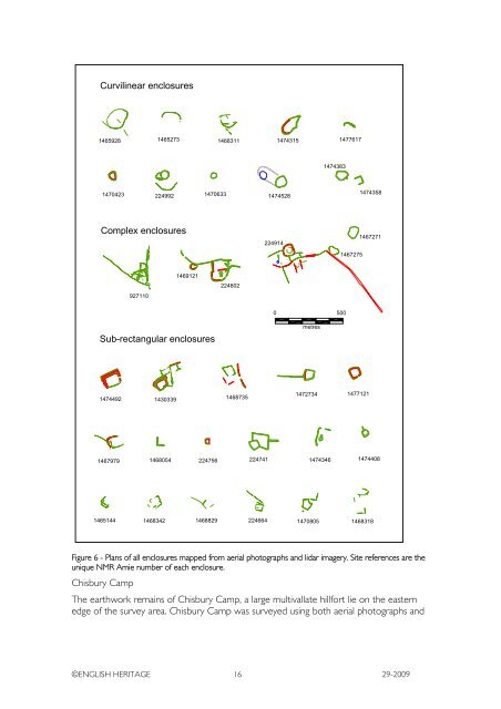
Figure 6 - Plans of all enclosures mapped from aerial photographs and lidar imagery. Site references are <strong>the</strong><br />
unique NMR Amie number of each enclosure.<br />
Chisbury Camp<br />
The earthwork remains of Chisbury Camp, a large multivallate hill<strong>for</strong>t lie on <strong>the</strong> eastern<br />
edge of <strong>the</strong> survey area. Chisbury Camp was surveyed using both aerial photographs and<br />
©ENGLISH HERITAGE 16 29-2009


