

savernake forest a report for the national mapping ... - English Heritage
savernake forest a report for the national mapping ... - English Heritage
savernake forest a report for the national mapping ... - English Heritage

You also want an ePaper? Increase the reach of your titles
YUMPU automatically turns print PDFs into web optimized ePapers that Google loves.
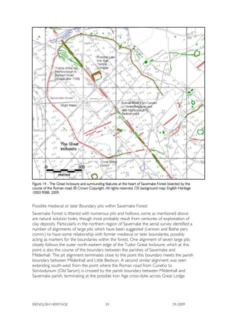
Figure 14 - The Great Inclosure and surrounding features at <strong>the</strong> heart of Savernake Forest bisected by <strong>the</strong><br />
course of <strong>the</strong> Roman road. © Crown Copyright. All rights reserved. OS background map: <strong>English</strong> <strong>Heritage</strong><br />
100019088. 2009.<br />
Possible medieval or later Boundary pits within Savernake Forest<br />
Savernake Forest is littered with numerous pits and hollows, some as mentioned above<br />
are natural solution holes, though most probably result from centuries of exploitation of<br />
clay deposits. Particularly in <strong>the</strong> nor<strong>the</strong>rn region of Savernake <strong>the</strong> aerial survey identified a<br />
number of alignments of large pits which have been suggested (Lennon and Ba<strong>the</strong> pers<br />
comm.) to have some relationship with <strong>for</strong>mer medieval or later boundaries, possibly<br />
acting as markers <strong>for</strong> <strong>the</strong> boundaries within <strong>the</strong> <strong><strong>for</strong>est</strong>. One alignment of seven large pits<br />
closely follows <strong>the</strong> outer north-eastern edge of <strong>the</strong> Tudor Great Inclosure, which at this<br />
point is also <strong>the</strong> course of <strong>the</strong> boundary between <strong>the</strong> parishes of Savernake and<br />
Mildenhall. The pit alignment terminates close to <strong>the</strong> point this boundary meets <strong>the</strong> parish<br />
boundary between Mildenhall and Little Bedwyn. A second similar alignment was seen<br />
extending south-west from <strong>the</strong> point where <strong>the</strong> Roman road from Cunetio to<br />
Sorviodunum (Old Sarum) is crossed by <strong>the</strong> parish boundary between Mildenhall and<br />
Savernake parish, terminating at <strong>the</strong> possible Iron Age cross-dyke across Great Lodge<br />
©ENGLISH HERITAGE 34 29-2009


