

savernake forest a report for the national mapping ... - English Heritage
savernake forest a report for the national mapping ... - English Heritage
savernake forest a report for the national mapping ... - English Heritage

You also want an ePaper? Increase the reach of your titles
YUMPU automatically turns print PDFs into web optimized ePapers that Google loves.
were also seen immediately to <strong>the</strong> south-west of <strong>the</strong> house on <strong>the</strong> opposite side of <strong>the</strong><br />
road which may be a continuation of one of <strong>the</strong>se ditches.<br />
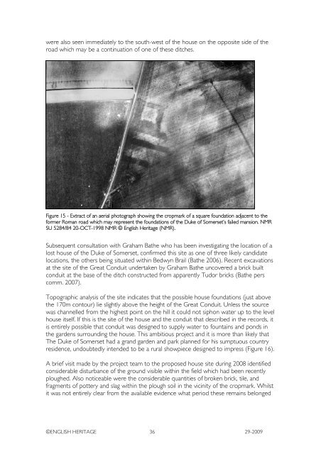
Figure 15 - Extract of an aerial photograph showing <strong>the</strong> cropmark of a square foundation adjacent to <strong>the</strong><br />
<strong>for</strong>mer Roman road which may represent <strong>the</strong> foundations of <strong>the</strong> Duke of Somerset’s failed mansion. NMR<br />
SU 5284/84 20-OCT-1998 NMR © <strong>English</strong> <strong>Heritage</strong> (NMR).<br />
Subsequent consultation with Graham Ba<strong>the</strong> who has been investigating <strong>the</strong> location of a<br />
lost house of <strong>the</strong> Duke of Somerset, confirmed this site as one of three likely candidate<br />
locations, <strong>the</strong> o<strong>the</strong>rs being situated within Bedwyn Brail (Ba<strong>the</strong> 2006). Recent excavations<br />
at <strong>the</strong> site of <strong>the</strong> Great Conduit undertaken by Graham Ba<strong>the</strong> uncovered a brick built<br />
conduit at <strong>the</strong> base of <strong>the</strong> ditch constructed from apparently Tudor bricks (Ba<strong>the</strong> pers<br />
comm. 2007).<br />
Topographic analysis of <strong>the</strong> site indicates that <strong>the</strong> possible house foundations (just above<br />
<strong>the</strong> 170m contour) lie slightly above <strong>the</strong> height of <strong>the</strong> Great Conduit. Unless <strong>the</strong> source<br />
was channelled from <strong>the</strong> highest point on <strong>the</strong> hill it could not siphon water up to <strong>the</strong> level<br />
house itself. If this is <strong>the</strong> site of <strong>the</strong> house and <strong>the</strong> conduit that described in <strong>the</strong> records, it<br />
is entirely possible that conduit was designed to supply water to fountains and ponds in<br />
<strong>the</strong> gardens surrounding <strong>the</strong> house. This ambitious project and it is more than likely that<br />
The Duke of Somerset had a grand garden and park planned <strong>for</strong> his sumptuous country<br />
residence, undoubtedly intended to be a rural showpiece designed to impress (Figure 16).<br />
A brief visit made by <strong>the</strong> project team to <strong>the</strong> proposed house site during 2008 identified<br />
considerable disturbance of <strong>the</strong> ground visible within <strong>the</strong> field which had been recently<br />
ploughed. Also noticeable were <strong>the</strong> considerable quantities of broken brick, tile, and<br />
fragments of pottery and slag within <strong>the</strong> plough soil in <strong>the</strong> vicinity of <strong>the</strong> cropmark. Whilst<br />
it was not entirely clear from <strong>the</strong> available evidence what period <strong>the</strong>se remains belonged<br />
©ENGLISH HERITAGE 36 29-2009


