

savernake forest a report for the national mapping ... - English Heritage
savernake forest a report for the national mapping ... - English Heritage
savernake forest a report for the national mapping ... - English Heritage

You also want an ePaper? Increase the reach of your titles
YUMPU automatically turns print PDFs into web optimized ePapers that Google loves.
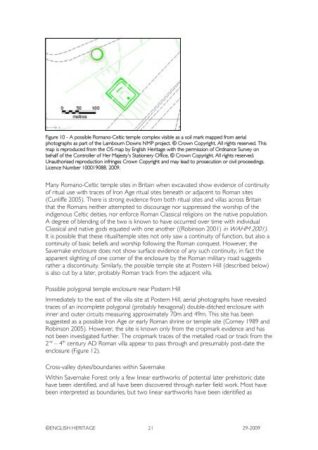
Figure 10 - A possible Romano-Celtic temple complex visible as a soil mark mapped from aerial<br />
photographs as part of <strong>the</strong> Lambourn Downs NMP project. © Crown Copyright. All rights reserved. This<br />
map is reproduced from <strong>the</strong> OS map by <strong>English</strong> <strong>Heritage</strong> with <strong>the</strong> permission of Ordnance Survey on<br />
behalf of <strong>the</strong> Controller of Her Majesty's Stationery Office, © Crown Copyright. All rights reserved.<br />
Unauthorised reproduction infringes Crown Copyright and may lead to prosecution or civil proceedings.<br />
Licence Number 100019088. 2009.<br />
Many Romano-Celtic temple sites in Britain when excavated show evidence of continuity<br />
of ritual use with traces of Iron Age ritual sites beneath or adjacent to Roman sites<br />
(Cunliffe 2005). There is strong evidence from both ritual sites and villas across Britain<br />
that <strong>the</strong> Romans nei<strong>the</strong>r attempted to discourage nor suppressed <strong>the</strong> worship of <strong>the</strong><br />
indigenous Celtic deities, nor en<strong>for</strong>ce Roman Classical religions on <strong>the</strong> native population.<br />
A degree of blending of <strong>the</strong> two is known to have occurred over time with individual<br />
Classical and native gods equated with one ano<strong>the</strong>r ((Robinson 2001) in WAHM 2001).<br />
It is possible that <strong>the</strong>se ritual/temple sites not only saw a continuity of function, but also a<br />
continuity of basic beliefs and worship following <strong>the</strong> Roman conquest. However, <strong>the</strong><br />
Savernake enclosure does not show surface evidence of any such continuity, in fact <strong>the</strong><br />
apparent slighting of one corner of <strong>the</strong> enclosure by <strong>the</strong> Roman military road suggests<br />
ra<strong>the</strong>r a discontinuity. Similarly, <strong>the</strong> possible temple site at Postern Hill (described below)<br />
is also cut by a later, probably Roman track from <strong>the</strong> adjacent villa.<br />
Possible polygonal temple enclosure near Postern Hill<br />
Immediately to <strong>the</strong> east of <strong>the</strong> villa site at Postern Hill, aerial photographs have revealed<br />
traces of an incomplete polygonal (probably hexagonal) double-ditched enclosure with<br />
inner and outer circuits measuring approximately 70m and 49m. This site has been<br />
suggested as a possible Iron Age or early Roman shrine or temple site (Corney 1989 and<br />
Robinson 2005). However, <strong>the</strong> site is known only from <strong>the</strong> cropmark evidence and has<br />
not been investigated fur<strong>the</strong>r. The cropmark traces of <strong>the</strong> metalled road or track from <strong>the</strong><br />
2 nd – 4 th century AD Roman villa appear to pass through and presumably post-date <strong>the</strong><br />
enclosure (Figure 12).<br />
Cross-valley dykes/boundaries within Savernake<br />
Within Savernake Forest only a few linear earthworks of potential later prehistoric date<br />
have been identified, and all have been discovered through earlier field work. Most have<br />
been interpreted as boundaries, but two linear earthworks have been identified as<br />
©ENGLISH HERITAGE 21 29-2009


