

savernake forest a report for the national mapping ... - English Heritage
savernake forest a report for the national mapping ... - English Heritage
savernake forest a report for the national mapping ... - English Heritage

You also want an ePaper? Increase the reach of your titles
YUMPU automatically turns print PDFs into web optimized ePapers that Google loves.
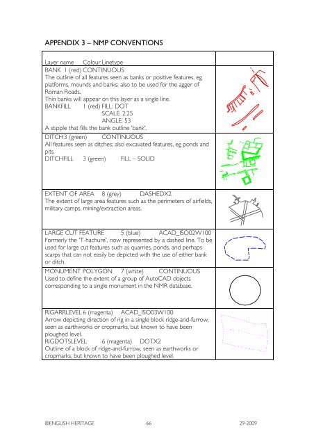
APPENDIX 3 – NMP CONVENTIONS<br />
Layer name Colour Linetype<br />
BANK 1 (red) CONTINUOUS<br />
The outline of all features seen as banks or positive features, eg<br />
plat<strong>for</strong>ms, mounds and banks; also to be used <strong>for</strong> <strong>the</strong> agger of<br />
Roman Roads.<br />
Thin banks will appear on this layer as a single line.<br />
BANKFILL 1 (red) FILL: DOT<br />
SCALE: 2.25<br />
ANGLE: 53<br />
A stipple that fills <strong>the</strong> bank outline 'bank'.<br />
DITCH 3 (green) CONTINUOUS<br />
All features seen as ditches; also excavated features, eg ponds and<br />
pits.<br />
DITCHFILL 3 (green) FILL – SOLID<br />
EXTENT OF AREA 8 (grey) DASHEDX2<br />
The extent of large area features such as <strong>the</strong> perimeters of airfields,<br />
military camps, mining/extraction areas.<br />
LARGE CUT FEATURE 5 (blue) ACAD_ISO02W100<br />
Formerly <strong>the</strong> 'T-hachure', now represented by a dashed line. To be<br />
used <strong>for</strong> large cut features such as quarries, ponds, and perhaps<br />
scarps that can not easily be depicted with <strong>the</strong> use of ei<strong>the</strong>r bank<br />
or ditch.<br />
MONUMENT POLYGON 7 (white) CONTINUOUS<br />
Used to define <strong>the</strong> extent of a group of AutoCAD objects<br />
corresponding to a single monument in <strong>the</strong> NMR database.<br />
RIGARRLEVEL 6 (magenta) ACAD_ISO03W100<br />
Arrow depicting direction of rig in a single block ridge-and-furrow,<br />
seen as earthworks or cropmarks, but known to have been<br />
ploughed level.<br />
RIGDOTSLEVEL 6 (magenta) DOTX2<br />
Outline of a block of ridge-and-furrow, seen as earthworks or<br />
cropmarks, but known to have been ploughed level.<br />
©ENGLISH HERITAGE 66 29-2009


