Digital Elevation Models/Terrain Analysis
Digital Elevation Models/Terrain Analysis
Digital Elevation Models/Terrain Analysis

You also want an ePaper? Increase the reach of your titles
YUMPU automatically turns print PDFs into web optimized ePapers that Google loves.
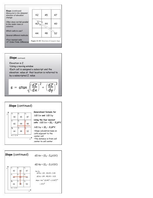
Slope (continued)<br />
Measured in the steepest<br />
direction of elevation<br />
change<br />
Often does not fall parallel<br />
to the raster rows or<br />
columns<br />
Which cells to use?<br />
Several different methods:<br />
•Four nearest cells<br />
•3 rd Order Finite Difference<br />
Slope (continued)<br />
<strong>Elevation</strong> is Z<br />
•Using a moving window<br />
•Each cell is assigned a subscript and the<br />
elevation value at that location is referred to<br />
by a subscripted Z value<br />
The most common formula:<br />
Slope (continued)<br />
Generalized formula for<br />
Z/x and Z/y<br />
Using the four nearest<br />
for Z<br />
cells :Z/x o<br />
= (Z<br />
ΔZ/Δx = (49 – 40)/20 = 5 – Z<br />
0.45 4 )2*C<br />
Z/y ΔZ/Δy = (45 (Z– 48)/20 = -0.15<br />
2 – Z 7 )2*C<br />
•Slope calculation base on<br />
cells adjacent to the<br />
center cell<br />
•The distance is from cell<br />
center to cell center<br />
Slope (continued)