Bilsthorpe & Rufford - Newark and Sherwood District Council
Bilsthorpe & Rufford - Newark and Sherwood District Council
Bilsthorpe & Rufford - Newark and Sherwood District Council

You also want an ePaper? Increase the reach of your titles
YUMPU automatically turns print PDFs into web optimized ePapers that Google loves.
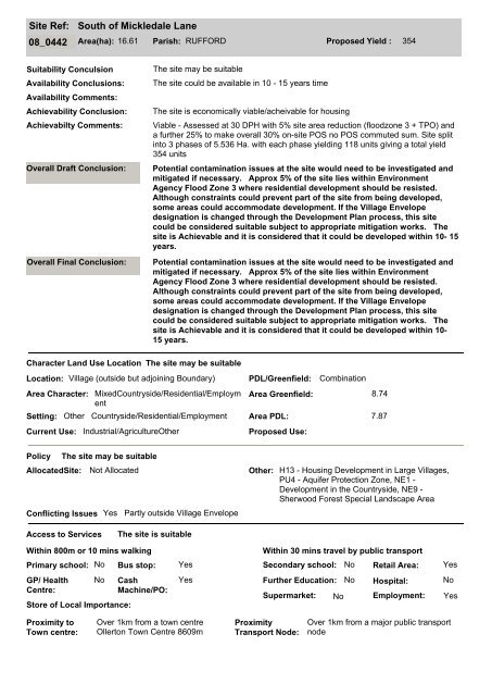
Site Ref:<br />
South of Mickledale Lane<br />
08_0442 Area(ha): 16.61 Parish: RUFFORD Proposed Yield : 354<br />
Suitability Conculsion<br />
Availability Conclusions:<br />
Availability Comments:<br />
Achievability Conclusion:<br />
Achievabilty Comments:<br />
Overall Draft Conclusion:<br />
Overall Final Conclusion:<br />
The site may be suitable<br />
The site could be available in 10 - 15 years time<br />
The site is economically viable/acheivable for housing<br />
Viable - Assessed at 30 DPH with 5% site area reduction (floodzone 3 + TPO) <strong>and</strong><br />
a further 25% to make overall 30% on-site POS no POS commuted sum. Site split<br />
into 3 phases of 5.536 Ha. with each phase yielding 118 units giving a total yield<br />
354 units<br />
Potential contamination issues at the site would need to be investigated <strong>and</strong><br />
mitigated if necessary. Approx 5% of the site lies within Environment<br />
Agency Flood Zone 3 where residential development should be resisted.<br />
Although constraints could prevent part of the site from being developed,<br />
some areas could accommodate development. If the Village Envelope<br />
designation is changed through the Development Plan process, this site<br />
could be considered suitable subject to appropriate mitigation works. The<br />
site is Achievable <strong>and</strong> it is considered that it could be developed within 10- 15<br />
years.<br />
Potential contamination issues at the site would need to be investigated <strong>and</strong><br />
mitigated if necessary. Approx 5% of the site lies within Environment<br />
Agency Flood Zone 3 where residential development should be resisted.<br />
Although constraints could prevent part of the site from being developed,<br />
some areas could accommodate development. If the Village Envelope<br />
designation is changed through the Development Plan process, this site<br />
could be considered suitable subject to appropriate mitigation works. The<br />
site is Achievable <strong>and</strong> it is considered that it could be developed within 10-<br />
15 years.<br />
Character L<strong>and</strong> Use Location<br />
Location: Village (outside but adjoining Boundary) PDL/Greenfield: Combination<br />
Area Character:<br />
Setting:<br />
Current Use:<br />
MixedCountryside/Residential/Employm<br />
ent<br />
Other Countryside/Residential/Employment<br />
Industrial/AgricultureOther<br />
The site may be suitable<br />
Area Greenfield: 8.74<br />
Area PDL: 7.87<br />
Proposed Use:<br />
Policy<br />
The site may be suitable<br />
AllocatedSite: Not Allocated Other: H13 - Housing Development in Large Villages,<br />
PU4 - Aquifer Protection Zone, NE1 -<br />
Development in the Countryside, NE9 -<br />
<strong>Sherwood</strong> Forest Special L<strong>and</strong>scape Area<br />
Conflicting Issues Yes Partly outside Village Envelope<br />
Access to Services<br />
The site is suitable<br />
Within 800m or 10 mins walking<br />
Primary school: No<br />
GP/ Health<br />
Centre:<br />
No<br />
Store of Local Importance:<br />
Cash<br />
Machine/PO:<br />
Yes<br />
Within 30 mins travel by public transport<br />
Bus stop: Yes Secondary school: No<br />
Further Education:<br />
Supermarket:<br />
No<br />
No<br />
Retail Area:<br />
Hospital:<br />
Employment:<br />
Yes<br />
No<br />
Yes<br />
Proximity to<br />
Town centre:<br />
Over 1km from a town centre<br />
Ollerton Town Centre 8609m<br />
Proximity<br />
Transport Node:<br />
Over 1km from a major public transport<br />
node