Bilsthorpe & Rufford - Newark and Sherwood District Council
Bilsthorpe & Rufford - Newark and Sherwood District Council
Bilsthorpe & Rufford - Newark and Sherwood District Council

You also want an ePaper? Increase the reach of your titles
YUMPU automatically turns print PDFs into web optimized ePapers that Google loves.
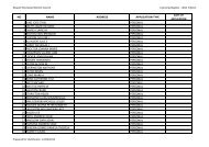
Site Ref:<br />
Rear of Highfields Drive<br />
08_0448 Area(ha): 4.56 Parish: BILSTHORPE Proposed Yield :<br />
Agricultural L<strong>and</strong> Quality: Grade 3 (Good-moderate)<br />
Neighbour Issues:<br />
no<br />
identified at the site<br />
Site Apparatus:<br />
power lines abutting Southern<br />
boundary<br />
Identified in SFRA: No<br />
SFRA Comments:<br />
Site within a flood<br />
zone?:<br />
In Floodzone 1<br />
Impact on L<strong>and</strong>scape Biodiversity<br />
Impact on views: No<br />
Impact on existing<br />
Recreational Use:<br />
ProtectedSpecies/<br />
Habitats:<br />
The site is suitable<br />
No but site adjoins Southwell<br />
Trail to West<br />
Yes Partially coincides with<br />
(Site adjoins) Southwell Trail<br />
to West - Local Nature<br />
Reserve. 2/541 - Farnsfield<br />
Disused Railway. Direct<br />
impacts can be expected.<br />
Natural Features: No<br />
Listed Bldg / Local Interest Bldg:<br />
Tree Preservation Order: No<br />
Conservation Area: No<br />
No<br />
Suitability Conclusion:<br />
The site is not suitable<br />
Availability <strong>and</strong> Achievability<br />
Availability Conclusions:<br />
Achievability Conclusion:<br />
Availability Comments:<br />
Achievabilty Comments:<br />
Ownership Constraints<br />
Legal Issues:<br />
Timescale:<br />
Ownership Comments:<br />
Legal Comments:<br />
Availability Other Issues:<br />
Viability Comments:<br />
Additional Comments: Mining Area - Smoke Control Area (Eastern side of site)<br />
Site borders SHLAA sites 08_0111 <strong>and</strong> 08_0449