Bilsthorpe & Rufford - Newark and Sherwood District Council
Bilsthorpe & Rufford - Newark and Sherwood District Council
Bilsthorpe & Rufford - Newark and Sherwood District Council

Create successful ePaper yourself
Turn your PDF publications into a flip-book with our unique Google optimized e-Paper software.
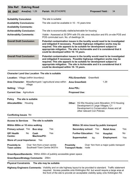
Site Ref:<br />
Eakring Road<br />
08_0447 Area(ha): 1.29 Parish: BILSTHORPE Proposed Yield : 34<br />
Suitability Conculsion<br />
Availability Conclusions:<br />
Availability Comments:<br />
Achievability Conclusion:<br />
Achievabilty Comments:<br />
Overall Draft Conclusion:<br />
Overall Final Conclusion:<br />
The site is suitable<br />
The site could be available in 10 - 15 years time<br />
The site is economically viable/acheivable for housing<br />
Viable - Assessed at 30 DPH with 5% site area reduction <strong>and</strong> 6% on-site POS <strong>and</strong><br />
POS commuted sum. No. of dwellings 34.<br />
Potential contamination issues in the locality would need to be investigated<br />
<strong>and</strong> mitigated if necessary. Possible highways mitigation works may be<br />
required. This site appears to be suitable for development subject to<br />
appropriate mitigation. The site is Achievable <strong>and</strong> it is considered that it<br />
could be developed within 10- 15 years.<br />
Character L<strong>and</strong> Use Location<br />
Location: Village (within boundary) PDL/Greenfield: Greenfield<br />
Area Character:<br />
Setting:<br />
Village<br />
Current Use:<br />
Mixedfarmyard / agricultural area within<br />
village<br />
Agriculture<br />
The site is suitable<br />
Area Greenfield: 1.29<br />
Area PDL:<br />
Proposed Use:<br />
Policy<br />
The site is suitable<br />
AllocatedSite: Housing Other: H2-Wa Housing L<strong>and</strong> Allocation; H13 Housing<br />
Development in Large Villages; C1<br />
Development in Conservation Areas <strong>and</strong> all<br />
other relevant Con Policies<br />
Conflicting Issues No<br />
Access to Services<br />
The site is suitable<br />
Within 800m or 10 mins walking<br />
Primary school: Yes<br />
GP/ Health<br />
Centre:<br />
No<br />
Store of Local Importance:<br />
Cash<br />
Machine/PO:<br />
Yes<br />
Within 30 mins travel by public transport<br />
Bus stop: Yes Secondary school: Yes<br />
Yes<br />
Further Education:<br />
Supermarket:<br />
No<br />
Yes<br />
Retail Area:<br />
Hospital:<br />
Employment:<br />
Yes<br />
No<br />
Yes<br />
Proximity to<br />
Town centre:<br />
Over 1km from a town centre<br />
Southwell Town Centre 9437m<br />
Proximity<br />
Transport Node:<br />
Over 1km from a major public transport<br />
node<br />
GreenSpaceSt<strong>and</strong>ards: Within 400m of publicly accessible green space<br />
GreenSpaceStrategy Comments: 256m<br />
Physical Constraints<br />
The site may be suitable<br />
Highway Engineers Comments: Visibility <strong>and</strong> on site highway layout to be provided to st<strong>and</strong>ard. Traffic statement<br />
required. Access possible onto Kirklington Rd but would require a large area at<br />
the front of the site to provide an acceptable visibility splay onto Kirklington Rd.