Bilsthorpe & Rufford - Newark and Sherwood District Council
Bilsthorpe & Rufford - Newark and Sherwood District Council
Bilsthorpe & Rufford - Newark and Sherwood District Council

You also want an ePaper? Increase the reach of your titles
YUMPU automatically turns print PDFs into web optimized ePapers that Google loves.
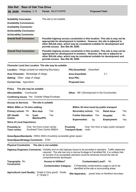
Site Ref:<br />
Rear of Oak Tree Drive<br />
08_0449 Area(ha): 2.10 Parish: BILSTHORPE Proposed Yield :<br />
Suitability Conculsion<br />
Availability Conclusions:<br />
Availability Comments:<br />
Achievability Conclusion:<br />
Achievabilty Comments:<br />
Overall Draft Conclusion:<br />
Overall Final Conclusion:<br />
The site is not suitable<br />
Possible highway access constraints in this location. This site is may not be<br />
appropriate for development in isolation. However, the site is adjacent to<br />
other SHLAA sites, which may be considered suitable for development <strong>and</strong><br />
provide access. See Site 08_0200.<br />
Possible highway access constraints in this location. This site is may not be<br />
appropriate for development in isolation. However, the site is adjacent to<br />
other SHLAA sites, which may be considered suitable for development <strong>and</strong><br />
provide access. See Site 08_0200.<br />
Character L<strong>and</strong> Use Location The site may be suitable<br />
Location: Village (outside but adjoining Boundary) PDL/Greenfield: Greenfield<br />
Area Character: Mixededge of village<br />
Area Greenfield: 2.1<br />
Setting: Other edge of village<br />
Area PDL:<br />
Current Use: Agriculture<br />
Proposed Use:<br />
Policy The site may be suitable<br />
AllocatedSite: Countryside Other: NE1 (Development in the Countryside)<br />
Conflicting Issues Yes Outside Village Envelope<br />
Access to Services<br />
The site is suitable<br />
Within 800m or 10 mins walking<br />
Primary school: No<br />
GP/ Health<br />
Centre:<br />
No<br />
Store of Local Importance:<br />
Cash<br />
Machine/PO:<br />
Yes<br />
Within 30 mins travel by public transport<br />
Bus stop: Yes Secondary school: Yes<br />
Further Education:<br />
Supermarket:<br />
No<br />
Yes<br />
Retail Area:<br />
Hospital:<br />
Employment:<br />
Yes<br />
No<br />
Yes<br />
Proximity to<br />
Town centre:<br />
Over 1km from a town centre<br />
Southwell Town Centre 9082m<br />
Proximity<br />
Transport Node:<br />
Over 1km from a major public transport<br />
node<br />
GreenSpaceSt<strong>and</strong>ards: Within 400m of publicly accessible green space<br />
GreenSpaceStrategy Comments: 219m<br />
Physical Constraints<br />
The site is not suitable<br />
Highway Engineers Comments: Visibility <strong>and</strong> on site highway layout to be provided to st<strong>and</strong>ard. Traffic statement<br />
required. The site has only a narrow frontage to Farnsfield Rd. It is unlikely that<br />
an access of an acceptable st<strong>and</strong>ard could be achieved should the site be<br />
comprehensively developed.<br />
Topography<br />
Constraints:<br />
No Access to Utilities?<br />
Contaminated L<strong>and</strong>?: No<br />
Contamination Category:<br />
Agricultural L<strong>and</strong> Quality: Grade 2 (Very good) Grade<br />
2 / Grade 3<br />
C-Potentially contaminative usage is yet to be<br />
identified at the site or surrounding areas<br />
Site Apparatus:<br />
power lines on Northern boundary