Bilsthorpe & Rufford - Newark and Sherwood District Council
Bilsthorpe & Rufford - Newark and Sherwood District Council
Bilsthorpe & Rufford - Newark and Sherwood District Council

You also want an ePaper? Increase the reach of your titles
YUMPU automatically turns print PDFs into web optimized ePapers that Google loves.
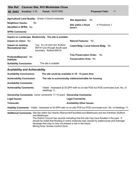
Site Ref:<br />
Caravan Site, R/O Mickledale Close<br />
08_0443 Area(ha): 0.35 Parish: RUFFORD Proposed Yield : 11<br />
Agricultural L<strong>and</strong> Quality: Grade 3 (Good-moderate)<br />
Neighbour Issues: No<br />
Identified in SFRA: No<br />
SFRA Comments:<br />
Site Apparatus:<br />
Site within a flood<br />
zone?:<br />
No<br />
In Floodzone 1<br />
Impact on L<strong>and</strong>scape Biodiversity<br />
Impact on views: No<br />
Impact on existing<br />
Recreational Use:<br />
ProtectedSpecies/<br />
Habitats:<br />
No<br />
Suitability Conclusion:<br />
The site is suitable<br />
Yes R o W 207/19/1 <strong>Rufford</strong><br />
BW19 runs through South-east<br />
boundary. <strong>Rufford</strong> BW19<br />
The site is suitable<br />
Natural Features: No<br />
Listed Bldg / Local Interest Bldg:<br />
Tree Preservation Order: No<br />
Conservation Area: No<br />
No<br />
Availability <strong>and</strong> Achievability<br />
Availability Conclusions:<br />
The site could be available in 10 - 15 years time<br />
Achievability Conclusion:<br />
The site is economically viable/acheivable for housing<br />
Availability Comments:<br />
Achievabilty Comments:<br />
Viable - Assessed at 30 DPH with no on-site POS but POS commuted sum. No. of<br />
dwellings 11.<br />
Ownership Constraints owner constraints 11-15 years<br />
Legal Issues:<br />
Timescale:<br />
Ownership Comments:<br />
Legal Comments:<br />
Availability Other Issues:<br />
Viability Comments: Viable - Assessed at 30 DPH with no on-site POS but POS commuted sum. No. of dwellings 11.<br />
Additional Comments: Site lies within two Wards (Rainworth/Farnsfield <strong>and</strong> <strong>Bilsthorpe</strong>) <strong>and</strong> two Parishes (<strong>Rufford</strong><br />
<strong>and</strong> <strong>Bilsthorpe</strong>)<br />
The <strong>District</strong> <strong>Council</strong> has records indicating that this site may have flooded in the past. It<br />
should be noted that flooding in some instances was caused by watercourse <strong>and</strong> drainage<br />
blockage that may or may not present a risk in the future.<br />
Mining Area- Smoke Control Zone