CIPA HERITAGE DOCUMENTATION - CIPA - Icomos
CIPA HERITAGE DOCUMENTATION - CIPA - Icomos
CIPA HERITAGE DOCUMENTATION - CIPA - Icomos

Create successful ePaper yourself
Turn your PDF publications into a flip-book with our unique Google optimized e-Paper software.
Common photogrammetric records are based on imagery<br />
and total stations. Planning of network for acquisition and data<br />
capture are time consuming; furthermore, post-processing<br />
work for image-based architectural surveying is tedious and<br />
requires a very high level of expertise. However, 3D laser scanners<br />
have proved to be more efficient in three-dimensional<br />
dense modelling. Although the local accuracy of measurements<br />
taken with robotized total stations is higher, laser-scanner<br />
surveys are often more appropriate for urgent interventions<br />
as they provide massive 3D volumetric information. Information<br />
processing provides metric data which are very useful to<br />
support conservation and restoration policies.<br />
Since the 2001 edition of <strong>CIPA</strong>, there has been a very<br />
large number of works published, focusing on the laser scanner<br />
and its application to heritage recording subject. [Boehler<br />
(2002), Malinverni (2003)].<br />
On the other hand, a large number of developments in<br />
Computer Graphics and Machine Vision for complex rendering<br />
of historical buildings have been performed along the last ten<br />
years. Modern scientific visualization offers the possibility to<br />
inspect and evaluate structural properties of buildings and<br />
other information relative to their environment. Thus, it is necessary<br />
to develop multi-resolution and hybrid approaches for<br />
architectural and environmental surveying (see e.g. El-Hakim<br />
et al, 2002). The development of interoperability tools between<br />
Surveying and Information Systems, including advanced<br />
visualization techniques models is the next challenge<br />
to face. Advanced Visualization must allow the exchange,<br />
processing and analysis of metric information with object-oriented<br />
data and metadata bases relative to the information<br />
with a 2D/3D support.<br />
For dealing with such a massive data source, it is necessary<br />
to combine volumetric segmentation with 3D matching to different<br />
level-of-detail (LoD). This combination provides a semiautomatic<br />
identification of primitives appearing in buildings for<br />
each LoD. The coarsest level of the hierarchy involves the identification<br />
of geometric elements (dominant planes, quadrics,<br />
e.g.) whereas the finest level deals with complex primitives (or-<br />
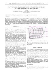
Figure 2: Scanning the Church of Santiago outdoors and indoors.<br />
namental details, pinnacles, ledges, sculptures, e.g.). The automatic<br />
identification of complex primitives from basic geometric<br />
primitives is still a challenge for semi-automatic 3D recognition<br />
and modelling with a large number of applications to CAD,<br />
Architectural or Archaeological Surveying, computer animation<br />
and simulation, including VR/AR, among others.<br />
Currently, the LFA-MoBiVAP research group is developing<br />
information systems for Cultural Heritage Recording by means<br />
of advanced visualization systems. Post-processing of 3D information<br />
arising from sampling of huge clouds of points makes it<br />
possible to compare the current state of certain areas with their<br />
simple planar and quadratic primitives. Multi-resolution models<br />
have been applied in the visualization and virtual reconstruction<br />
of archaeological sites; examples of these are the<br />
analysis and ideal reconstruction of the roman theater of Clvnia<br />
(Burgos, Spain) as illustrated in [Finat et al 2005] and an<br />
extension for urban environments, in [Fernandez, 2006].<br />
The main goal of this work is to contribute to the semi-automatic<br />
3D modelling and design of architectural primitives<br />
corresponding to damaged buildings from range data files<br />
from scanning. To achieve this goal, simpler PL-models (piecewise<br />
linear) are generated from huge unorganized clouds of<br />
points captured with the laser scanner Ilris 3D (Optech). Sections<br />
of the point-clouds (understood as equispaced slices<br />
with constant width) and projections of selected ones onto reference<br />
planes are the result of the performed projective operations.<br />
These partial intermediate models are obtained with<br />
low computational cost and they are enough to identify coarse<br />
structural damages before urgent interventions.<br />
Methodology<br />
According to the methodology planned the steps performed in<br />
this and other precedent works is resumed as follows:<br />
1. Data capture and construction of a global model by means<br />
of multiple scans alignining.<br />
2. Global orientation of the model using ground control<br />
points. A high precision levelling traverse has been done.<br />
42 <strong>CIPA</strong> <strong>HERITAGE</strong> <strong>DOCUMENTATION</strong> BEST PRACTICES AND APPLICATIONS Series I, 2007 & 2009