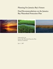
Syr Darya0 500 1,000 kmHuang HeAmu DaryaYangtze<strong>In</strong>dusGangesBrahmaputraIrrawadySalweenMekongGlaciersRiversBasinsIrrigated AreasUrban ExtentElevation (meters)40 – 500 500 – 1,000 1,000 – 2,000 2,000 – 4,000 4,000 – 6,000 6,000 – 8,000
3.1 Asia: Glacier melt and irrigated agricultural systemsGlobally, glaciers are retreating at alarming rates. 19 Glaciers areslow moving masses <strong>of</strong> ice that store accumulated snowfall overdecades and even centuries. Glaciers flow down mountainsides,melting at the lower ends while more snow accumulates at theupper ends. Because <strong>of</strong> this constant regeneration throughwinter snow pack, they store water during winter monthsand feed rivers during summer months, regulating the flowdownstream. 20Shrinking glaciers provide a one-time “dividend” <strong>of</strong> water releaseto downstream regions. 21 As the storage capacity <strong>of</strong> glaciersis lost, flooding risks increase in the medium term. This canaffect rural agriculture and urban areas located in river deltas.Once the glacier disappears, it no longer releases water duringthe summer months. The disappearance <strong>of</strong> glaciers impliesdecreased water supply and untimely flows—that is, comingin the wrong (non-cropping) season. The only alternative <strong>for</strong>seasonal water storage are dams, which are costly to constructand can have significant environmental and social impacts,resulting in the displacement <strong>of</strong> thousands or, in rare cases,millions <strong>of</strong> people. 22The Himalayas are known as the Water Tower <strong>of</strong> Asia. Theglacier-fed rivers originating from the Himalaya mountainranges surrounding the Tibetan Plateau comprise the largestriver run-<strong>of</strong>f from any single location in the world. 23 The riversthat drain these mountains move through some <strong>of</strong> the mostpopulous areas in the world. <strong>In</strong> the year 2000, the river basins <strong>of</strong>the <strong>In</strong>dus, Ganges, Brahmaputra, Irrawaddy, Salween, Mekong,Yangtze, and Huang He (Yellow) Rivers collectively supporteda population <strong>of</strong> 1.4 billion people, or almost a quarter <strong>of</strong> theworld’s population.Himalayan glaciers are already in retreat. 24 Their dependenceon glacier run<strong>of</strong>f makes downstream populations particularlyvulnerable to the consequences. The <strong>In</strong>dus River valley supportsone <strong>of</strong> the largest irrigation works in the world (16.2m ha).Approximately 90 percent <strong>of</strong> Pakistan’s crop production is grownunder irrigation, and all <strong>of</strong> the water comes from barrages alongthe <strong>In</strong>dus. The Ganges, Yangtze, and Yellow Rivers also havelarge areas under irrigation —17.9m ha, 5.4m ha, and 2.0m ha,respectively.Hydropower installations along the Mekong and Yangtze are alsosignificant suppliers <strong>of</strong> electricity to urban markets. The recentlycompleted Three Gorges Dam on the Yangtze, the world’s largesthydroelectric installation, will have a power generation capacity<strong>of</strong> 22,500 MW once all generators are installed, more than 20times the capacity <strong>of</strong> an average coal-fired or nuclear powerplant. The project, however, has already displaced 1–2 millionpeople. 25 Plans are underway to add significant hydropowergenerating capacity to the Mekong over the coming decades.Under scenarios <strong>of</strong> rapid glacier melt, it is likely that hundredsmore water retention dams will be constructed. Collectively, thesewill have significant impacts on downstream flow regimes anddeltas, which are already starved <strong>of</strong> flood waters and replenishingsediment. 26 Population displacement and resettlement willbecome larger issues in these areas at significant scales.As a result <strong>of</strong> the intensification <strong>of</strong> cultivation in irrigated areasand power generation, many millions indirectly depend on thefood and energy resources generated by these great rivers. Butthe rivers also provide direct livelihoods to all those employedin irrigated agriculture, small-scale fishing, and aquaculture, andthey are at the heart <strong>of</strong> cultural traditions. For example, to HindusWhat does this map tell us?The map depicts glaciers (white with blue border) in the Himalayas and the major rivers that flow from them. These rivers supportlarge irrigated areas (dark green) and major population centers (red), yet the glaciers that feed them are in retreat. Reductions <strong>of</strong>river flows will affect irrigated areas, but the potential <strong>for</strong> migration out <strong>of</strong> agricultural areas is hard to predict, and will depend onadaptation responses such as dam construction and more efficient irrigation technologies. Broader impacts on food security <strong>for</strong> thishighly populous region could be significant. <strong>In</strong> the absence <strong>of</strong> diversification and adaptation/mitigation measures, as water resourcesgradually diminish agriculture livelihoods will become unsustainable, and people may be <strong>for</strong>ced to leave. Paradoxically, measures tostore water and ward <strong>of</strong>f a water crisis related to shrinking glaciers could result in further displacement and resettlement.the Ganges is sacred, and is personified in Mother Gaṅgā (GaṅgāMātā), representative <strong>of</strong> life-giving maternal waters. 27 Changesin the rivers and livelihoods dependent on them could bringpr<strong>of</strong>ound economic, cultural, and demographic impacts.Should flow reductions become acute, the potential <strong>for</strong> migrationout <strong>of</strong> irrigated areas could be significant. 28 Although destinationareas are hard to predict, it is likely that most migrating ordisplaced people would move to small to medium sized citiesinland, and a smaller number would move to large megacitiesalong the coasts or on the main branches <strong>of</strong> river systems (e.g.Delhi). 29 Movement from interior to coastal areas—a pattern thathas been prevalent in China since the early 1980s—will resultin larger populations vulnerable to sea level rise, and possiblyto extreme floods from upstream regions as the regulatingeffect <strong>of</strong> glaciers diminish. 30 However, many South Asia citieslack the capacity to absorb significant migration streams. Thereis potential <strong>for</strong> significant water saving efficiencies in irrigatedareas <strong>of</strong> Asia, and if properly implemented this may <strong>for</strong>estalldisplacements <strong>of</strong> farmers. 315©CARE/Peter Newsum