In Search of Shelter - Center for International Earth Science ...
In Search of Shelter - Center for International Earth Science ...
In Search of Shelter - Center for International Earth Science ...

You also want an ePaper? Increase the reach of your titles
YUMPU automatically turns print PDFs into web optimized ePapers that Google loves.
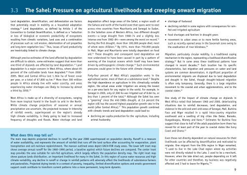
3.3 The Sahel: Pressure on agricultural livelihoods and creeping onward migrationLand degradation, desertification, and de<strong>for</strong>estation are factorsthat potentially result in mobility as a household adaptationstrategy. 46 Land degradation, as defined by Article 1 <strong>of</strong> theConvention to Combat Desertification, is defined as a “reductionor loss <strong>of</strong> biological or economic productivity <strong>of</strong> ecosystemsresulting from climatic variations, land uses and a combination<strong>of</strong> processes such as: soil erosion, deterioration <strong>of</strong> soil propertiesand long-term vegetation loss.” Thus, losses <strong>of</strong> land productivityare inextricably linked to climate change.Although precise estimates <strong>of</strong> the land affected by degradationare difficult to obtain, some estimates suggest that more thanone-third <strong>of</strong> drylands are affected by land degradation. 47 Landdegradation is a major concern in West Africa, where about 65percent <strong>of</strong> the cultivable lands have degraded. 48 From 2000-2005, West and Central Africa lost 1.36m ha <strong>of</strong> <strong>for</strong>est coverper year, or a total <strong>of</strong> 67,800 sq km. 49 More than 300 millionpeople in Africa already live with water scarcity, and areasexperiencing water shortages are likely to increase by almosta third by 2050. 50West Africa is made up <strong>of</strong> a diversity <strong>of</strong> ecosystems, rangingfrom more tropical humid in the South to arid in the North.While climate change projections <strong>of</strong> seasonal or annualprecipitation are uncertain, the projected increase in intensity<strong>of</strong> rainfall events, superimposed on the region’s alreadyhigh climate variability, is likely going to lead to increasedfrequency <strong>of</strong> droughts and floods. Water shortage and landdegradation affect large areas <strong>of</strong> the Sahel, a region south <strong>of</strong>the Sahara and north <strong>of</strong> the humid zone that spans west to eastacross nine countries from Mauritania and Senegal to Sudan.<strong>In</strong> the Sahelian zone <strong>of</strong> Western Africa, two different droughtevents—a large drought from 1968–74 and a slightly lessintense one from 1982–84—were among the worst on record. 51During the first drought, more than 100,000 people died, most<strong>of</strong> whom were children. 52 By 1974, more than 750,000 peoplein Mali, Niger and Mauritania were totally dependent on foodaid. 53 These droughts and consequent land degradation arenow understood to have been caused in part by a pattern <strong>of</strong>warming <strong>of</strong> the tropical oceans which itself may have beendriven by anthropogenic climate change. 54 Such environmentalpressures could grow in the future with climate change.Forty-four percent <strong>of</strong> West Africa’s population works in theagricultural sector, most <strong>of</strong> them at a subsistence level. 55 Despitethe high dependence on agriculture in this climatically variableregion, the actual areas under irrigation are among the loweston a per-area basis <strong>for</strong> any region in the world. For example, inSenegal in 2005, only 67,000 ha was irrigated out <strong>of</strong> 8.8m ha, orless than 1 percent <strong>of</strong> the total. 56 Although the Sahel has seena “greening” since the mid-1980s drought, at 2.6 percent theregion still has the second highest population growth rate in theworld (after Central Africa). 57 This population growth combinedwith climatic trends and land degradation could lead to:• declining per capita production <strong>for</strong> the agriculture, includinganimal husbandryWhat does this map tell us?The main map depicts projected declines in run<strong>of</strong>f by the year 2080 superimposed on population density. Run<strong>of</strong>f is a measure<strong>of</strong> water availability, and represents the amount <strong>of</strong> rainfall that runs <strong>of</strong>f the land surface after accounting <strong>for</strong> evaporation, planttranspiration and soil moisture replenishment. The maroon outlined areas depict EACH-FOR study areas. The lower left inset mapshows average annual run<strong>of</strong>f <strong>for</strong> the 1960–1990 period, a baseline against which future declines are compared. The center insetmap provides the area suitable <strong>for</strong> rain-fed agriculture, which largely reflects the population density map. The right inset mapshows pasture lands distribution, an important livelihood <strong>for</strong> many in the Sahel. <strong>In</strong> this region <strong>of</strong> scarce water resources and highclimate variability, any decline in run<strong>of</strong>f or change in rainfall patterns will adversely affect the livelihoods <strong>of</strong> subsistence farmersand pastoralists. Projected drying trends in a context <strong>of</strong> poverty, inequality, limited diversification options and erratic governmentsupport could contibute to trans<strong>for</strong>m current patterns into a more permanent, long-term dynamic.• shortage <strong>of</strong> fuelwood• declining rainfall in some regions with consequences <strong>for</strong> rainfedand irrigated agriculture• food shortages and famines in drought years• movement to urban areas or to more fertile farming areas,such as recently opened areas in the Savannah zone owing tothe eradication <strong>of</strong> river blindness. 58Migration, particularly circular mobility, is a traditional copingmechanism in the region, representing a livelihood diversificationstrategy. 59 But in some areas these traditional patterns havechanged in recent decades. 60 Each location has its specificcharacteristics, but migration and pressures on water and landsystems are common denominators. A significant proportion <strong>of</strong>environmental migrants are displaced due to land degradationand drought in the Sahel, though drought-induced migrationis <strong>of</strong>ten only temporary. Generally, there is a large migrationmovement to the coastal and urban agglomerations, and to thecoastal states. 61One study <strong>of</strong> the impact <strong>of</strong> climate change on drylands inWest Africa noted that between 1960 and 2000, deterioratingsituations due to rainfall decreases, land degradation, andviolence in the arid and semi-arid areas <strong>of</strong> Senegal, Mali, BurkinaFaso and Niger resulted in a rapid intra-country migrationsouthward and a swelling <strong>of</strong> big cities like Dakar, Bamako,Ouagadougou, Niamey and Kano. 62 Estimates <strong>for</strong> Burkina Fasosuggest that close to half <strong>of</strong> the adult population born there hasmoved <strong>for</strong> at least part <strong>of</strong> the year to coastal states like IvoryCoast and Ghana. 63Even those not directly dependent on natural resources <strong>for</strong> theirlivelihoods can be affected by desertification and motivated tomigrate. One migrant from the Difa region in Niger remarked,“I used to live in the Lake Chad region where my activitieswere not directly related to the Lake. I used to be a merchant.However, when the lake dried out, people depending on it left<strong>for</strong> other countries and there<strong>for</strong>e, my business was negativelyaffected and I had to leave <strong>for</strong> Nigeria.” 649