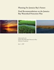
EACH-FORStudy AreaCountry BordersChange in Run<strong>of</strong>f (percent)(–) negative 0positive (+)50 – 25 24 – 5 4 – 4 5 – 24 25 – 50Population Density, 2000 (persons per km²)0 1 – 4 5 – 24 25 – 249 250 – 999 1,000 +MéxicoAverage Annual Run<strong>of</strong>f, 1960 – 1990 (mm)BelizeHonduras0 – 100 101 – 200 201 – 500 501 – 750 751 – 1,000GuatemalaEl SalvadorNicaraguaSuitability <strong>of</strong> Agricultural Land <strong>for</strong> Rain-Fed CropsCyclone Frequency, 1980 – 2000Costa RicaPanamá6poorsatisfactory good excellentLowHigh0 500 1,000 km
3.2 Mexico and Central America: Migration in response to drought and disastersMultiple climate-related hazards threaten Mexico and CentralAmerica. This region is known <strong>for</strong> the severity <strong>of</strong> cyclone events,with Hurricane Mitch in 1998 leaving devastation in its wake inHonduras and Nicaragua, and Hurricane Stan in 2005 affectingMexico and Guatemala. Tropical storm Noel in 2007 caused heavyflooding in the state <strong>of</strong> Tabasco, where up to 80 percent <strong>of</strong> thestate was inundated. Several coastal regions in Mexico will facesea level rise, particularly low lying areas <strong>of</strong> the Gulf Coast andthe Caribbean. 32Of particular concern, however, is the likelihood that the regionwill see persistent declines in precipitation over the course <strong>of</strong>this century. The map at left shows that run<strong>of</strong>f in the region willlikely decline by at least 5 percent and possibly more than 70percent, with declines getting progressively worse in the semiaridand arid north. 33 Given the region’s mountainous topography,extensive irrigation is only practicable in the coastal plains thatare dominated by wealthy landowners. Most smallholder farmerswill remain heavily dependent on rain-fed agriculture. However,even large-scale irrigated areas, such as those in Sonora andSinaloa states, the breadbasket <strong>of</strong> Mexico, will be affected asaverage reservoir levels decline. Already, summer droughts duringEl Niño and La Niña events can lead to serious deficits in reservoirlevels. 34<strong>In</strong> the case <strong>of</strong> Guatemala, longer and more intensemidsummer drought periods have been linked to long-termdeclines in rainfall since the 1970s. 35 This drought determines thelevel <strong>of</strong> success or failure <strong>of</strong> rain-fed agriculture.Processes <strong>of</strong> slow-onset land degradation including de<strong>for</strong>estation,soil erosion, and desertification already affect large parts <strong>of</strong> theMexico and Central America. <strong>In</strong> the fragile arid and semi-aridecosystems <strong>of</strong> northern and north-western Mexico more than 60percent <strong>of</strong> the land is considered to be in a total or accelerated state<strong>of</strong> erosion, and mountainous lands with high slopes throughout theregion have suffered de<strong>for</strong>estation and soil erosion.EACH-FOR studies were conducted in the hurricane-proneChiapas state <strong>of</strong> Southern Mexico, and in Tlaxcala state, a highlydesertified state in Central Mexico. Both areas are consideredvery vulnerable to the effects <strong>of</strong> climate change, particularly incombination with de<strong>for</strong>estation, erosion, and underlying povertyand social vulnerability. 36Migration is already a response in Mexico to changingenvironmental conditions, the 1980s agricultural crisis andeconomic liberalization. 37 When Hurricane Stan passed throughChiapas, many people were surprised by the violence <strong>of</strong> itsimpact. One interviewee noted, “The river took away our homesand properties; we also were close to being taken away.” 38 Yetwhen very low-income villagers were asked whether migrationwas an option <strong>for</strong> them, most respondents underlined that theyhave no other place to go. Yet, <strong>for</strong> those who are better <strong>of</strong>f orwho have relatives abroad, migration is an option.The recurrence <strong>of</strong> natural disaster combined with the presence <strong>of</strong>relatives who emigrated due to disasters in the past increases thedesire <strong>of</strong> farmers to emigrate. 39 On the other hand, diversification<strong>of</strong> livelihood strategies 40 and government investment on disasterrisk management decreases the likelihood <strong>of</strong> migration, regardless<strong>of</strong> poverty status. 41Some studies have shown links between desertification andmigration in Mexico, 42 noting the impacts on agriculturallivelihoods. <strong>In</strong> dryland areas such as Tlaxcala, which depends onrain-fed agriculture, the majority <strong>of</strong> interviewees complained <strong>of</strong>shifting rainfall periods, which increases uncertainty and causesa decline in crop yields and incomes. The area <strong>of</strong> Tlaxcala isprojected to have a 10–20 percent decline in run<strong>of</strong>f in associationwith climate change. This indirect link between climatic changesand migration was noted frequently in fieldwork, mostly relatedto unreliable harvests linked to changing rainfall patterns. Returnmigration, and seasonal migration as a livelihood diversificationstrategy have been documented in this area. As explained by twointerviewees:“…when our harvest is bad, we have to rely on ourselves.Many <strong>of</strong> us had to leave, to Canada or the United States…the money I made there… was a big help <strong>for</strong> my family.Without that income, it would have become extremelydifficult.” 43“My grandfather, father and I have worked these lands. Buttimes have changed…the rain is coming later now, so that weproduce less. The only solution is to go away, at least <strong>for</strong> awhile [to the United States]. But leaving my village <strong>for</strong>ever?No. I was raised here and here I will stay.” 44The relevance temporary migration and remittances to copewith unreliable income from agriculture has <strong>of</strong>ten beenhighlighted in the environment-migration literature but notalways sufficiently considered in adaptation and mitigationpolicies.What does this map tell us?The main map depicts projected changes in run<strong>of</strong>f by 2080. Run<strong>of</strong>f is a measure <strong>of</strong> water availability and represents the amount <strong>of</strong>rainfall that runs <strong>of</strong>f the land surface after accounting <strong>for</strong> evaporation, plant transpiration, and soil moisture replenishment. Mexicoand Central America will be widely affected by declines. The map also outlines the Mexican states <strong>of</strong> Tlaxcala and Chiapas, where EACH-FOR conducted research. The top left inset map shows average annual run<strong>of</strong>f <strong>for</strong> the 1960–1990 period, a baseline against which futuredeclines will be applied. The bottom left inset map shows lands suited <strong>for</strong> rain-fed agriculture, which will be particularly affected byprogressive drying in the region. Circular, temporary and seasonal migration has traditionally been a means <strong>of</strong> coping with climatevariability in these areas, and permanent internal and international migration out <strong>of</strong> areas dependent on rain-fed agriculture is adistinct possibility. The inset on the lower right depicts cyclone frequency in the 1980–2000 period. Some models show the number<strong>of</strong> category 4 and 5 hurricanes increasing in the Caribbean.<strong>In</strong>ternal and international migration patterns are wellestablished in Mexico and Central America, 45 and it is difficultto project what effects drying trends associated with climatechange may have. It is clear, however, that environmentalfactors like desertification and extreme weather alreadycontribute to the regions’ complex pattern <strong>of</strong> human mobility.The opportunity <strong>for</strong> some people to migrate seasonally, sendremittances, and return home is an example <strong>of</strong> migrationas an adaptation strategy to deteriorating environmentalconditions.7