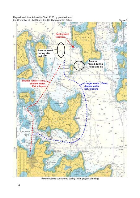
Reproduced from Admiralty Chart 2250 by permission ofthe Controller of HMSO and the UK Hydrographic OfficeFigure 3DeploymentlocationArea to avoidduring ebband NWArea toavoid duringflood and SEShorter route (11nm),shallow water.Est. 4 hoursLonger route (16nm),deeper water.Est. 6 hoursRoute options considered during initial project planning4
1.3.2 The voyageAt 1300 on 8 September 2006, the tug <strong>Harald</strong>, towing the jack-up barge <strong>Octopus</strong>,sailed from Kirkwall for Seal Skerry Bay. It was the day before spring tides, the visibilitywas good, and wind was light and variable. As planned, the tug Erlend escorted thetug and tow on passage. <strong>Harald</strong>’s skipper planned the voyage with Admiralty papercharts, and used the charts for navigation together with a Seatrack monochrome chartplotter. The echo sounder was running throughout the voyage, although the depthtrace prior to the grounding was illegible – possibly due to the turbulence caused by thefast flowing tides.Once clear of the approaches to Kirkwall, the tow master requested the tug skipper’sagreement to lower the barge legs from 5m to around 9m. This was to improve<strong>Octopus</strong>’s stability in the anticipated swell east of Shapinsay.The tow’s progress through the water was slightly reduced as the barge trimmedforward when the legs were extended. As the tug and tow approached the Falls ofWarness at 1730, the following spring ebb tide, flowing at about 6 knots, set the tugand barge to the west. The tug skipper was aware that the westerly set continuedthrough the Falls of Warness and would set them towards the Green Holm islands. Hetherefore discussed the situation with the tow master on the barge by VHF radio, andthey agreed to pass to the west of Little Green Holm Island, a route <strong>Harald</strong>’s skipperhad used many times before. As the tug and tow altered course to the west-northwestto pass west of the Green Holm islands, their speed increased to 8 knots over theground aided by the ebb tide (Figure 4).Following the decision to pass west of the Green Holm islands, the tow master and tugskipper agreed to lower the barge legs to 13m to reduce the expected rolling as theycrossed the tidal flow to the north of the Falls of Warness. They also agreed to havethe barge legs at the required depth for the installation on arrival in Seal Skerry Bay.At 1755, half an hour after low water, <strong>Octopus</strong> grounded on her forward two legs, 3cables south-south-west of Little Green Holm Island (Figure 5). The charted depthat the position of the grounding was assessed to be greater than 20m, the closestsounding indicating a depth of 26m. The force of the grounding caused some of thebarge personnel to fall, however no one was injured and neither the tug nor the bargedeck cargo was damaged.1.3.3 Post grounding actions<strong>Harald</strong>’s skipper reacted quickly to the grounding by using astern propulsion and payingout the towing cable. The escort tug Erlend promptly connected a tow to the stern of<strong>Octopus</strong> to relieve the strain on the barge legs and to hold her in position awaiting therising tide and reduction in the tidal flow.Erlend’s skipper informed Orkney Towage of the grounding but did not request anyassistance. The workboat Ailsa, awaiting the arrival of the tug and tow in Seal SkerryBay, headed for the grounding position.Shortly after the grounding, <strong>Octopus</strong>’s personnel were transferred to Ailsa. While theworkboat was alongside <strong>Octopus</strong>, her skipper confirmed the depth of water as 8m,which included a height of tide of 0.5m.5