Octopus Harald - Marine Accident Investigation Branch
Octopus Harald - Marine Accident Investigation Branch
Octopus Harald - Marine Accident Investigation Branch

You also want an ePaper? Increase the reach of your titles
YUMPU automatically turns print PDFs into web optimized ePapers that Google loves.
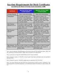
1.7.6 CHP survey effortAll survey work is managed by the MCA, in close liaison with the UKHO. Using arisk based approach, survey priorities are divided between moving sea bed activity,mostly in the South East of England, and the survey and resurvey of prioritised areasto modern standards. The majority of the MCA budget is spent in commissioninghydrographic survey contracts with commercial surveying companies. Contracts areawarded following tenders, with between five and seven companies routinely bidding foreach contract.The current MCA methodology for survey prioritisation uses a risk based approach, asrecommended in the 1997 University of Wales Report. To assist in survey prioritisation,the MCA, in conjunction with the UKHO, intends to develop a risk matrix, whichcombines survey source data from the UKHO’s Archive Catalogue with information ofshipping movements derived from the Automatic Identification System (AIS). The MCAanticipated that, in time, AIS traffic data would replace the existing method of identifyingtrends in traffic density.The MCA’s own dedicated surveying resource is the Emergency Towing Vessel (ETV)Anglian Sovereign which has the ability to carry out modern multi-beam sonar surveywork when not engaged in her primary role as an ETV or conducting other operationalrequirements. Anglian Sovereign is normally available to carry out survey work on 120days annually.The current status of Civil Hydrography around the UK coast is shown on UKHO chartQ6090 (Figure 12).1.7.7 Other surveying activity1. The MoDThe MoD establishes survey requirements for naval operations and activities aroundthe UK coast. Defence priorities are not open to civil examination or discussion.The military survey programme operates separately from the CHP, although thetwo are interconnected. The Royal Navy’s Hydrographic vessels are deployedworldwide with the exception of HMS Gleaner, which surveys mainly the UK Coast.Data is supplied for use on Admiralty charts and publications where appropriate.The UKHO liaises closely with the MCA to ensure there is no duplication of surveyeffort where this is possible.2. Harbour AuthoritiesPort Authorities are responsible for survey data within their own Statutory HarbourAuthority areas. Bi-lateral agreements on sharing survey data exist between mostUK ports and the UKHO.3. Supplementary survey dataAdditional survey information is obtained from commercial operators, such as majoroil companies, and from reports sent by maritime users through HydrographicNotices.20