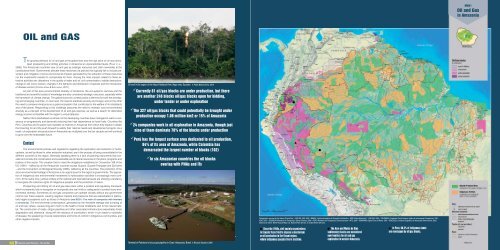
MOG1Oil and Gasin AmazoniaOIL and GASThe growing demand for oil and gas at the global level and the high price of oil have stimulatedprospecting and drilling activities in Amazonia at unprecedented levels (Finer et al.,2008). The Amazonian countries view oil and gas as strategic resources and claim ownership at theconstitutional level. Governments allocate these resources via policies that typically fail to include preventionand mitigation of socio-environmental impacts generated by the extraction of these resourcesnor the investments needed to compensate for them. Among the main impacts related to these extractiveactivities are: alterations in the quality of water and air, soil contamination, habitat destruction,change in soil cover, erosion, changes in the behavior and distribution of species and the introductionof disease vectors (Correa-Viana & Esclasans, 2011).As part of the socio-environmental diversity of Amazonia, the eco-systemic services and thetraditional and scientific bodies of knowledge are also considered strategic resources, especially withinthe framework of climate change. The global economic context poses a dilemma for both the developingand emerging countries: on one hand, the need to eradicate poverty and hunger, and on the otherthe need to conserve Amazonia as a grand ecosystem that contributes to the welfare of its inhabitantsand of the planet. Responding to this challenge presumes the need to maintain socio-environmentaldiversity as a vital part of the development of oil and gas reserves, as well as a search for alternativeenergy sources compatible with the region’s unique features.Neither the industrialized countries nor the developing countries have managed to reach a consensuson progressively and decisively reducing their high dependence on fossil fuels. Countries likePerú, Colombia and Ecuador have sizeable oil reserves in Amazonia from which they expect to obtainthe financing for and the push forward to satisfy their national needs and development projects. As aresult, oil exploration and production in Amazonia has multiplied over the last decade and will continueto grow over the foreseeable future.ContextThe environmental policies and regulations regarding the exploration and extraction of hydrocarbons,as well as those for other extractive industries, are in the process of being consolidated in thedifferent countries of the region. Generally speaking there is a lack of planning instruments that considerand include the conservation and sustainable use of natural resources in the plans, programs andpolicies of this sector. This situation fails to meet the obligations established in Convention 169 of theILO (1991) – ratified by all the Amazonian countries except Guyana, Guyane Française and Suriname– and the Convention on Biological Diversity (CBD), ratified by all the countries. The protection of thesocio-environmental heritage of Amazonia is an urgent issue for the region’s governments. The oppositionof indigenous and environmental movements to hydrocarbon activities is increasingly more common.At the same time, judicial entities at the national and international levels are showing a tendancyto recognize the collective rights of indigenous peoples and the protection of nature.Prospecting and drilling for oil and gas take place within a political and regulatory frameworkwhich consistently fails to recognize or incorporate any real limits or safeguards to protect socio-environmentaldiversity. Sometimes oil and gas companies can operate virtually without any governmentcontrol over these aspects, causing negative impacts and pressures that are exacerbated in particularlyfragile ecosystems such as those of Amazonia (see BOG1: The main oil companies with interestsin Amazonia). The environmental contamination, generated by the inevitable leakage and dumping ofoil and toxic refuse, causes long-term harm to the health of local inhabitants and to the natural habitat.The construction of roads, oil/gas pipelines and other associated infrastructure exacerbates forestdegradation and clearance, along with the advance of colonization, which in turn leads to outbreaksof disease, the weakening of social relationships and forms of control in indigenous communities, andother negative impacts.Oil well in the region of the Yasuní National Park, Napo river, Ecuador. © Pablo Baños/Avina, 2010 Currently 81 oil/gas blocks are under production, but thereare another 246 blocks oil/gas blocks open for bidding,under tender or under exploration The 327 oil/gas blocks that could potentially be brought underproduction occupy 1.08 million km2 or 15% of Amazonia 24 companies work in oil exploration in Amazonia, though justnine of them dominate 78% of the blocks under production Perú has the largest surface area dedicated to oil production,84% of its area of Amazonia, while Colombia hasdemarcated the largest number of blocks (102) In six Amazonian countries the oil blocksoverlap with PNAs and ITsĸ¾Cartographic sources for the theme Oil and Gas: • BOLIVIA: FAN, 2009 • BRASIL: <strong>Instituto</strong> Brasileiro de Geografia e Estatística - IBGE, Malha Municipal 1:1.000.000, 2005 • COLOMBIA: Fundación Puerto Rastrojo (Atlas de la Amazonía Colombiana), 2001;IGAC, 2010 • ECUADOR: Ministerio de Transporte y Obras Públicas, 2006 • PERÚ: Ministerio de Transporte y Comunicaciones - MTC, 2008 • SURINAME: Digital Chart of World, 1993 • VENEZUELA: <strong>Instituto</strong> Geográfico de Venezuela Simón Bolívar, 2003.Ocean and relieve: World Physical Map, U.S. National Park Service, in ArcGIS Online Services.<strong>RAISG</strong> 24Amazonia under Pressure – Oil and GasOilTerminal of Petrobras’s Urucu gas pipeline in Coari. Amazonas, Brasil. © Ricardo Stuckert, 2006Ä Since the 1990s, civil society organizationsin Ecuador have tried to impose a moratoriumon oil production in the Yasuní region,where indigenous peoples live in isolation.¾ The Acre and Madre de Diossedimentary basins are considerednew frontiers for oil and gasexploration in western Amazonia.¸ In Perú, 66.3% of indigenous landsare overlapped by oil/gas blocks.and Gas – Amazonia under Pressure 25 <strong>RAISG</strong>
BOG2. State, oil and indigenous lands in the Ecuadorian AmazoniaMethodologyThe georeferenced information on the concessionary blocks awarded for hydrocarbon activitieswas compiled from different secondary sources located in the different Amazonian countries. Theseblocks were classified into four types according to their current phase: Open for Bidding (concessionaryblocks offered by the government), Under Tender (concessionary blocks with a pending offerawaiting official approval), Under Exploration (concessionary blocks with a company actively prospecting)and Under Production (concessionary blocks producing oil or gas). TOG1 shows which of the sixcountries that offer concessionary hydrocarbon blocks recognize each of these phases.In order to display the results, block polygons were ignored when the area overlapping the unitsof analysis was less than 9 ha.Amazonia as a wholeThere are currently 327 hydrocarbon blocks in Amazonia. They cover a total area of 1,082,704km 2 (14% of Amazonia’s surface). These include those Open for Bidding (6.2%), those Under Tender(1.8%), those Under Exploration (5.6%) and those Under Production (0.5%). The 81 blocks now underproduction occupy 40,717 km 2 , while the blocks in the other three phases occupy a total area of1,041,988 km 2 (TOG2).80% (263) of the blocks are concentrated in the Andean Amazonia (MOG2). It should be emphasizedthat this region contains almost half of the indigenous peoples, including those still living inisolation, half of the water, the largest biodiversity per unit area and the most varied socio-environmentalservices in the entire Amazon region.MOG2. Oil/gas blocks in Amazonia, by activity phaseBOG1. The main oil companies with interests in AmazoniaAt least 71 oil companies are now operating in Amazonia. Among them are 20 public and private companies that,combined, are operating in 60% of the surface area delimited as oil concessions (approximately 648,000 km 2 ).There are 24 companies involved in oil production at the regional level. Nine of them operate in 78% (31,835 km 2 ) ofthe surface of the concessions in this phase. Those with the largest concessions are: Pluspetrol of Argentina with 8,826km 2 in Peru; the Ecuadorian Petroamazonas EP with 4,785 km 2 in Ecuador; the Anglo-French Perenco with 4,616 km 2 inEcuador; and Petroriental of China with 3,197 km 2 in Ecuador.There are 50 companies operating across Amazonia in the exploration phase. Ten of them cover 67% (288,548 km 2 )of the surface area of concessions in the exploration phase. The companies exploring the largest areas are: Petrobraswith 61,487 km 2 ; Talisman Energy of Canada with 30,491 km 2 ; OGX Petróleo e Gás Ltda of Brazil with 28,744 km 2 in thesame call in Brazil; and the US company Burlington with 27,197 km 2 in Peru.Companies with oil/gas blocks over 10,000 km 2#Total areaCompanyCountries(km 2 )1 Agencia Nacional de Hidrocarburos 87,624 Colombia Open for bidding2 Petrobras 72,131 Bolivia, Brasil,Colombia, PerúPhasesOpen for bidding, under exploration, underproduction3 Talisman 54,248 Colombia, Perú Open for bidding, under exploration4 YPFB Petroandina 53,837 Bolivia Open for bidding5 Upland Oil & Gas 37,080 Perú Under tender6 Pluspetrol 36,864 Colombia, Perú Open for bidding, under exploration, underproduction7 Petron Resources 29,441 Perú Under tender8 Burlington 29,197 Ecuador, Perú Under exploration, under production9 OGX Petróleo e Gás Ltda, 28,744 Brasil Under exploration10 Petra Energía S/A 26,719 Brasil Under exploration11 CEPSA 25,748 Perú Under exploration12 REPSOL-YPF 24,582 Bolivia, Ecuador, Perú Under exploration, under production13 Pacific Stratus Energy 24,112 Colombia, Perú Under exploration14 M&S Brasil S,A, 23,184 Brasil Under exploration15 BHP Billiton Petroleum 19,666 Colombia Open for bidding16 Hunt Oil 18,695 Perú Under exploration17 Petrolifera 16,640 Perú Under exploration18 Grantierra Energy 14,671 Colombia, Perú Under exploration, under production19 Ecopetrol S,A, 14,226 Colombia Open for bidding, under exploration, underproduction20 Petrominerales 10,926 Colombia, Perú Under explorationUntil the mid 20 th century light crude oil was extracted off the coast of Ecuador by Anglo, providing relatively few benefits for thecountry. During the dispute over the border between Ecuador and Peru (1941), oil surveying was begun in the south central part ofthe Ecuadorian Amazonia by Shell.Two decades later activities began in the northeastern sub-region (bordering with Colombia) where, in 1967, Texaco-Gulf beganextracting oil at the Lago Agrio 1 well and the state oil company CEPE (subsequently Petroecuador and today Petroamazonas EP)began activities in the Amazonas District, which included wells, fields, stations, oil pipelines, multi-purpose pipelines and roads, aswell as oil towns: Lago, Coca, Shushufindi and Sacha. This meant the forced relocation, ethnocide and acculturation of indigenouspeoples like the Tetete (now extinct) and other Tukano-speaking groups (Siona and Secoya), Barbacoano (Cofán) and Waorani.One can still see the Texaco legacy in this region including pools with waste and toxic water that flows into the rivers or undergroundwater system, degradation and deforestation, tied to cases of leukemia and other cancers. Consequently in 1994 a group of30,000 people affected by this toxic legacy decided to sue in a US court those responsible for these operations at the time, Texacoand today Chevron, which absorbed the former almost a decade ago.Although oil income has financed much of the national revenue since 1972 when exports began, Amazonian oil is not as importanta factor in the country’s energy security as it should be since Ecuador imports oil derivatives (naphta, liquefied gas and bunker) for adomestic market seriously distorted by subsidized prices (U$ 1.5/gal). In the face of this, in the mid 1990s civil and indigenous organizationsrequested a moratorium on the extraction of heavy crude oil in protected areas and intangible zones for indigenous peoplesliving in voluntary isolation, such as in the Yasuní.This was a forerunner of the initiative adopted by the government in 2008 to leave 900 million barrels of oil in the ground in exchangefor compensation from the international community equivalent to 50% of the estimated revenue from oil exports. It was also argued thatthis deal would enable the reduction of emissions in an effective form shared between exporting and consuming countries. Howeverthere has been no concrete response, not so much because of the novelty of the financing mechanism – run by the UNDP – but becauseof the lack of guarantees for the continuity of this ‘post-oil’ policy. From the beginning, President Correa warned that if the initiative isnot consolidated, ‘Plan B’ will be launched within a limited time-frame for the extraction of these proven reserves.Although the supposed start of this plan has been postponed since 2009, the beginning of a new oil round has also been announcedwith the intention of tendering 2 million hectares in the south central part of the Ecuadorian Amazonia where the surveys byShell and Petroecuador proved negative for commercial reserves. This puts increased pressure on a region of high importance dueto its large socio-environmental diversity (headwaters of the Pastaza, Tigre and Morona rivers), because the government and the oilcompanies anticipate extending the oil frontier south from its current center in the northeast, affecting indigenous territories (Achuar,Andoa, Sapara, Shiwiar and Kichwa de Pastaza) in a sub-region that contains few protected or natural heritage areas (PANE). Priorinformed consultation also lacks a consistent legal framework after a presidential decree annulled the specific regulations in 2008.Neither the pre-legislative nor popular consultation established by the Constitution seem viable options for maintaining the protectedareas free of hydrocarbon activities, especially now that the State is set to pay China (US$ 5 billion) with the anticipated sale of oil upuntil 2016. (Víctor López/EcoCiencia)expected reserves of 120 million barrels of oil, were put up for bidding (BOG2: State, oil and indigenousterritories in Equatorial Amazonia). In terms of surface area the largest threat is found in Perú and Colombiawhere the hydrocarbon blocks open for bidding plus those already under exploration occupy82.9% and 24.4% of these two countries’ Amazonian territories (TOG4).By basinThe Amazonian macro-basins containing the largest surface areas of hydrocarbon blocks (inany phase) are the Upper Amazonas (with 855,120 km 2 , equivalent to 42% of the basin’s total surfacearea), Orinoco (138,349 km 2 , 26%) and Madeira (131,522 km 2 , 11%) (MOG3). The ten sub-basins withthe largest surface areas of oil blocks are found in the Upper Amazonas macro-basin (TOG5 andMOG4).MOG3. Proportion of oil/gas blocks per macro-basin in AmazoniaGOG1. Distribution of surface area of oil/gas blocks in Amazonia, by activity phase and countrySource: <strong>RAISG</strong> Databasis (see Cartographic sources in MOG1).TOG1. Oil/gas activity phases in Amazonia, by countryCountry Open for bidding Under tender Under exploration Under productionBolivia X X XBrasil X XColombia X X XEcuadorXPerú X X X XVenezuela X XMOG4. Proportion of oil/gas blocks per sub-basin in AmazoniaTOG4. Surface area of oil/gas blocks in Amazonia, by activity phase and country (km 2 )Country Open for bidding Under tender Under exploration Under production Total Amazon area (km 2 )Perú 253,447 133,336 262,385 10,770 659,937 782,820Colombia 170,003 21,367 2,044 193,414 483,164Brasil 126,843 1,019 127,862 5,006,316Bolivia 53,837 17,879 1,500 73,215 479,264Ecuador 24,957 24,957 116,284Venezuela 2,892 427 3,319 453,915Total 477,286 136,228 428,473 40,717 1,082.704 7,321.763<strong>RAISG</strong> 26Amazonia in each countryThe Amazonian countries with the largest surface areas dedicated to hydrocarbon activities inall phases are: Perú (84%), Colombia (40%) and Ecuador (21%). Ecuador is the country with the largestarea of hydrocarbon blocks under production in Amazonia. Although only 3% of Brazilian Amazoniahas blocks, these occupy 127,862 km2, which represents the third largest surface area after Perú andColombia (TOG3). Colombia is the country that has demarcated the largest number of blocks (102),followed by Perú (92), Bolivia and Brasil (55 each) (GOG1). Venezuela, considered the oil producer parexcellence, has demarcated few blocks in the Amazonian portion of the country since its main reservesare located outside this region (PDVSA, 2012). In Brasil most of the blocks under production are foundoffshore. Similarly in Suriname, Guyana and Guyane Française the majority of concessionary blocksare also located in their territorial waters (Kriege & Chedi-Toelsie, 2006; Way, 2012).In Ecuador the information obtained refers exclusively to blocks under production, but the countryis known to have begun the XI Oil Round, in which 12 blocks in the southeast of the country, withAmazonia under Pressure – Oil and GasOilTOG2. Quantity and surface area of oil/gas blocks in Amazonia. by activity phasePhase Number of blocks Area (km 2 ) % of total blocks % of total AmazoniaOpen for bidding 85 477,286 44.1% 6.2%Under tender 20 136,228 12.6% 1.8%Under exploration 141 428,473 39.6% 5.6%Under production 81 40,717 3.8% 0.5%Total 327 1,082.704 100.0% 14.0%TOG3. Quantity and surface area of oil/gas blocks in Amazonia, by countryCountry Amazon area (km 2 ) Nº of blocksBlocks area % surface of blocks in relation to(km 2 )Amazonia by countryPerú 782,820 92 659,937 84%Colombia 483,164 102 193,414 40%Ecuador 116,284 14 24,957 21%Bolivia 479,264 55 73,215 15%Brasil 5,006.316 55 127,862 3%Venezuela 453,915 9 3,319 1%Guyana 214,969 0 - -Guyane Française 86,504 0 - -Suriname 163,820 0 - -Total 7,787.056 327 1,082.704 15%TOG5. The ten Amazonian sub-basins with the largest overlap of oil/gas blocks (km 2 )Sub-basinSub-basin Area coveredarea (km 2 ) by blocks (km 2 )% PhaseUcayali (middle) 22,046 21,946 100 Under exploration, under tender, open for biddingMarañón (middle) 4,284 4,264 100 Under exploration, under tender, open for biddingMarañón (lower) 2,223 2,213 100 Open for bidding, under explorationMarañón (middle-lower) 36,342 36,159 99 Open for bidding, under exploration, under productionAmazonas Alto (middle) 27,832 26,371 95 Open for bidding, under explorationPachitea 29,026 26,520 91 Under exploration, under tender, open for biddingUcayali (lower) 111,078 101,217 91 Open for bidding, under explorationAmazonas Alto (lower) 32,941 29,825 91 Under exploration, under tender, open for bidding, under productionMarañón 81,498 72,585 89 Under exploration, under tender, open for biddingTambo 32,405 27,892 86 Under exploration, under tender, open for biddingand Gas – Amazonia under Pressure 27 <strong>RAISG</strong>