nguti council monographic study - Impact monitoring of Forest ...
nguti council monographic study - Impact monitoring of Forest ...
nguti council monographic study - Impact monitoring of Forest ...
- No tags were found...

You also want an ePaper? Increase the reach of your titles
YUMPU automatically turns print PDFs into web optimized ePapers that Google loves.
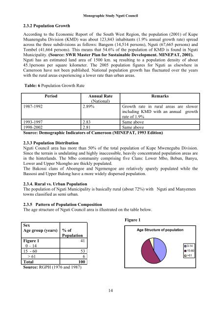
Monographic Study Nguti Council2.3.2 Population GrowthAccording to the Economic Report <strong>of</strong> the South West Region, the population (2001) <strong>of</strong> KupeMuanenguba Division (KMD) was about 123,843 inhabitants (1.9% annual growth rate) spreadacross the three subdivisions as follows: Bangem (14,514 persons), Nguti (67,665 persons) andTombel (41,664 persons). This means that 54.6% <strong>of</strong> the population <strong>of</strong> KMD is found in NgutiMunicipality. (Source: SWR Master Plan for Sustainable Development. MINEPAT, 2001).Nguti has an estimated land area <strong>of</strong> 1500 km. sq resulting to a population density <strong>of</strong> about45.1persons per square kilometer. The 2005 population figures for Nguti as elsewhere inCameroon have not been published. National population growth has fluctuated over the yearswith the rural areas experiencing a lower rate than urban areas.Table: 6 Population Growth RatePeriodAnnual RateRemarks(National)1987-1992 2.89% Growth rate in rural areas are slowerincluding KMD with an annual growthrate <strong>of</strong> 1.9%1993-1997 2.83 Same above1998-2002 2.81 Same aboveSource: Demographic Indicators <strong>of</strong> Cameroon (MINEPAT, 1993 Edition)2.3.3 Population DistributionNguti Council area has more than 50% <strong>of</strong> the total population <strong>of</strong> Kupe Mweneguba Division.Since the terrain is undulating and highly inaccessible, heavily concentrated population areas arein the hinterlands. The Mbo community comprising five Clans: Lower Mbo, Bebun, Banyu,Lower and Upper Nkongho are thickly populated.The Bakossi clans <strong>of</strong> Aboengoe and Ngemengoe are relatively sparely populated while theBassosi and Upper Balong have a more widely dispersed population.2.3.4. Rural vs. Urban PopulationThe population <strong>of</strong> Nguti Municipality is basically rural (about 72%) with Nguti and Manyementowns classified as semi urban.2.3.5 Pattern <strong>of</strong> Population CompositionThe age structure <strong>of</strong> Nguti Council area is illustrated on the table below.SexAge group (years)% <strong>of</strong>Population41Figure 10 – 1415 - 60 53> 61 6Total 100Source: RGPH (1976 and 1987)Figure 1Age Structure <strong>of</strong> population0-1415-60>6114