nguti council monographic study - Impact monitoring of Forest ...
nguti council monographic study - Impact monitoring of Forest ...
nguti council monographic study - Impact monitoring of Forest ...
- No tags were found...

Create successful ePaper yourself
Turn your PDF publications into a flip-book with our unique Google optimized e-Paper software.
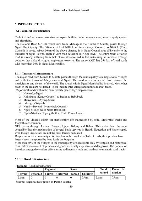
Monographic Study Nguti Council5. INFRASTRUCTURE5.1 Technical InfrastructureTechnical infrastructure comprises transport facilities, telecommunication, water supply systemand electricity.The National Road 8(NR8), which runs from, Mutengene via Kumba to Mamfe, passes throughNguti Municipality. The 50km stretch <strong>of</strong> NR8 from Supe (Konye Council) to Nfaitok (TintoCouncil) is tarred. About 30km <strong>of</strong> the above distance is in Nguti Council area (Nkwenfor to theoutskirts <strong>of</strong> Nguti Town). There is 2km road deviation in Nguti town. The entire 50km <strong>of</strong> tarredroad is already suffering from lack <strong>of</strong> maintenance and is fast witnessing an increase <strong>of</strong> largepotholes that make driving an unpleasant exercise. The entire KMD has 336 km <strong>of</strong> rural roadswith more than 30% in Nguti Municipality.5.1.1. Transport InfrastructureThe major road from Kumba to Mamfe passes through the municipality touching several villagesand both the towns <strong>of</strong> Manyemen and Nguti. The road serves as a vital link between themunicipality and the rest <strong>of</strong> the world. The stretch within Nguti Municipality is tarred. Most otherroads in the area are not tarred. These include inter village and farm to market roads.Major rural roads within the municipality (see village map) include:1. Nkwenfor-Nguti2. Kokobuma (Konye Council) to Badun to Babubock3. Manyemen – Ayong-Sikam4. Ediengo -Osiyarib5. Nguti—Bayenti (Eyumojock Council)6. Nguti-Mungo Ndor-Ntale-Babubock7. Nguti-Nfaitock / Eyang (both in Tinto Council area)Most <strong>of</strong> the villages within the municipality are inaccessible by road. Motorbike tracks andfootpaths are common.NR8 passes through 3 clans: Bassosi, Upper Balong and Bebun. This make them the mostaccessible thus the implantation <strong>of</strong> several basic services in Health, Education and Water supplyeven though these clans are not the most thickly populatedDespite immense community effort to address the problem <strong>of</strong> lack <strong>of</strong> roads, their produce havelargely been transported by head loads on footpathsMore than 80% <strong>of</strong> the villages in the municipality are accessible only by footpath and motorbike.This makes movement <strong>of</strong> persons and goods extremely expensive and dangerous. The populationhas <strong>of</strong>ten engaged relentless efforts using rudimentary tools and methods to maintain road tracks.5.1.1.1. Road InfrastructureTable22: Road InfrastructureRegional Rural Total FarmTarred Untarred Tarred Untarred Tarred Untarredtarred market32km 0 0 0 0 75km 32km 75kmSource: Regional Delegation <strong>of</strong> Public Works40to