
You also want an ePaper? Increase the reach of your titles
YUMPU automatically turns print PDFs into web optimized ePapers that Google loves.
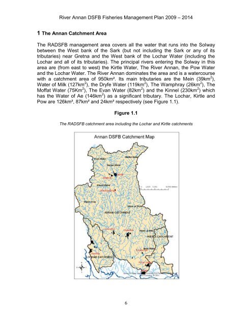
River <strong>Annan</strong> DSFB Fisheries <strong>Management</strong> <strong>Plan</strong> 2009 – 20141 The <strong>Annan</strong> Catchment AreaThe RADSFB management area covers all the water that runs into the Solwaybetween the West bank of the Sark (but not including the Sark or any of itstributaries) near Gretna and the West bank of the Lochar Water (including theLochar and all of its tributaries). The principal rivers entering the Solway in thisarea are (from east to west) the Kirtle Water, The River <strong>Annan</strong>, the Pow Waterand the Lochar Water. The River <strong>Annan</strong> dominates the area and is a watercoursewith a catchment area of 950km². Its main tributaries are the Mein (39km 2 ),Water of Milk (127km 2 ), the Dryfe Water (119km 2 ), The Wamphray (26km 2 ), TheMoffat Water (75Km 2 ), The Evan Water (82km 2 ) and the Kinnel (230km 2 ) whichhas the Water of Ae (146km 2 ) as a significant tributary. The Lochar, Kirtle andPow are 126km², 87km² and 24km² respectively (see Figure 1.1).Figure 1.1The RADSFB catchment area including the Lochar and Kirtle catchments6