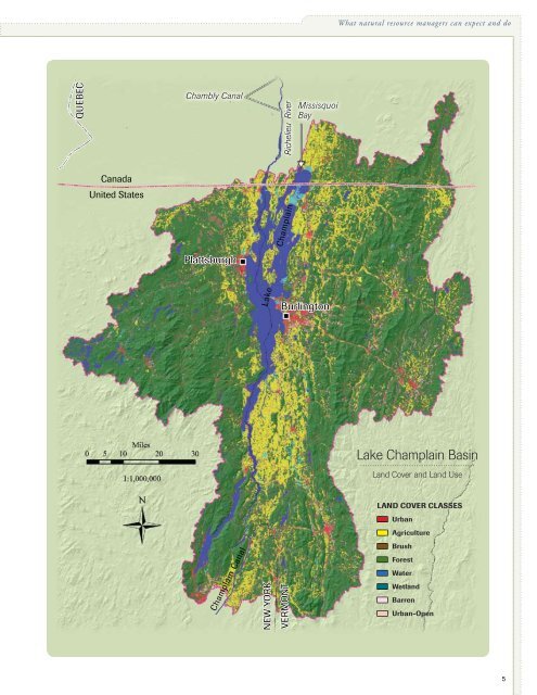
<strong>Climate</strong> <strong>Change</strong> <strong>in</strong> <strong>the</strong> Champla<strong>in</strong> Bas<strong>in</strong>II. IntroductionDespite <strong>the</strong> pervasiveness, importance andlong-last<strong>in</strong>g nature of modern climate change,most natural resource management plans for<strong>the</strong> Champla<strong>in</strong> Bas<strong>in</strong> do not yet take full account of it.Many of <strong>the</strong>se bluepr<strong>in</strong>ts were developed before <strong>the</strong>rewas widespread scientific consensus that human-drivenclimatic changes will present serious challenges to localecosystems and communities for <strong>the</strong> foreseeable future.However, climate change is already hav<strong>in</strong>g both subtleand readily visible effects on <strong>the</strong> bas<strong>in</strong>, and more impactsare likely to come <strong>in</strong> <strong>the</strong> decades ahead. Anticipat<strong>in</strong>g<strong>the</strong>se impacts and act<strong>in</strong>g far enough <strong>in</strong> advance of<strong>the</strong>m to mitigate or adapt to <strong>the</strong>m effectively will requiredeliberate, well-<strong>in</strong>formed and proactive management.<strong>The</strong> goal of this study is to assess <strong>the</strong> patterns and ecologicalconsequences of recent and future climate change <strong>in</strong> <strong>the</strong>Champla<strong>in</strong> Bas<strong>in</strong> and to help stimulate research and managementpractices that can most effectively support diversespecies assemblages and habitats <strong>in</strong> a warm<strong>in</strong>g future.Physical sett<strong>in</strong>gLake Champla<strong>in</strong> is 120 miles (193 km) long from north tosouth, and up to 12 miles (19 km) wide (<strong>in</strong>terrupted bya breakwater; <strong>the</strong> greatest open-water width is 8 miles),with a surface area of 435 square miles (1127 sq. km). Itsmaximum depth is 400 feet (122 m) and average depthis 64 feet (19.5 m) [LCBP, 2004; J.E. Marsden, personalcommunication]. Lake Champla<strong>in</strong> dra<strong>in</strong>s to <strong>the</strong> north via <strong>the</strong>Richelieu River <strong>in</strong>to <strong>the</strong> St. Lawrence River; <strong>the</strong> ChamblyCanal, opened <strong>in</strong> 1843, bypasses rapids on <strong>the</strong> Richelieu toallow navigation. <strong>The</strong> lake has also been connected s<strong>in</strong>ce1823 to <strong>the</strong> Hudson River via <strong>the</strong> Champla<strong>in</strong> Canal.come primarily (95%) from nonpo<strong>in</strong>t sources, with 46% ofthat from developed land and a little more than a third fromagricultural land (LCBP, 2008; Smeltzer et al., 2009). <strong>The</strong>watershed:lake area ratio is 18:1, and 78% of <strong>the</strong> bas<strong>in</strong> iscomposed of natural cover, which <strong>in</strong>cludes forests, wetlandsand open water.As shown <strong>in</strong> a later section of this report, <strong>in</strong>ter-annual fluctuations<strong>in</strong> lake levels are strongly <strong>in</strong>fluenced by changes <strong>in</strong>regional precipitation, which today averages more than 40–45<strong>in</strong>ches (100–115 cm) per year <strong>in</strong> <strong>the</strong> mounta<strong>in</strong>s and 30–35<strong>in</strong>ches (75–90 cm) at low elevations. Lake levels typicallyvary on <strong>the</strong> order of 3–6 feet (ca. 1–2 m) over <strong>the</strong> course ofa year, with a mean elevation of 95.5 feet (ca. 29 m) abovesea level. Observational records from Burl<strong>in</strong>gton, VT, showseasonal maximum levels occurr<strong>in</strong>g <strong>in</strong> April–May and m<strong>in</strong>imumlevels occurr<strong>in</strong>g <strong>in</strong> September–October (NOAA, 2006).Precipitation tends to be most abundant <strong>in</strong> summer and autumn,so <strong>the</strong> April–May lake level highs reflect snowmelt andrunoff from frozen or water-saturated soils more than directdeposition <strong>in</strong> spr<strong>in</strong>g, and <strong>the</strong> autumn lows may largely reflectreduced soil moisture and greater evaporative and transpirationlosses dur<strong>in</strong>g <strong>the</strong> warmer months. <strong>The</strong> historical range oflake levels spans a record high of 101.9 feet above mean sealevel, measured <strong>in</strong> April 1993, and a low of 92.6 feet, measured<strong>in</strong> December 1908 (USGS, 2006).Map 1. <strong>The</strong> Lake Champla<strong>in</strong> watershed encompasses8,234 square miles: 56% is located <strong>in</strong> Vermont, 37%<strong>in</strong> New York and 7% <strong>in</strong> Quebec. Includ<strong>in</strong>g forests, wetlandsand open water, 78% of <strong>the</strong> watershed is naturalcover. Agricultural land accounts for 16% of <strong>the</strong> watershed.Six percent is developed land.Data Source: Land Use / Land Cover for <strong>the</strong> Lake Champla<strong>in</strong>Bas<strong>in</strong>, circa 2001, University of Vermont, Spatial Analysis Lab.Map by D. Farrell, <strong>The</strong> <strong>Nature</strong> <strong>Conservancy</strong>, Vermont ChapterLake Champla<strong>in</strong>’s multi-state and bi-national watershedencompasses 8,234 square miles (21,326 sq. km), 56% ofwhich lies <strong>in</strong> Vermont, 37% <strong>in</strong> New York and 7% <strong>in</strong> Quebec(Map 1). A little more than a half million people livewith<strong>in</strong> its boundaries. Dozens of rivers and streams, <strong>in</strong> eightmajor dra<strong>in</strong>ages, flow <strong>in</strong>to Lake Champla<strong>in</strong>, carry<strong>in</strong>g 90%of <strong>the</strong> water that enters <strong>the</strong> lake (LCBP, 2008). Excessivephosphorus loads caus<strong>in</strong>g “cultural eutrophication” (undesirablegrowth of aquatic plants and/or phytoplankton)4
What natural resource managers can expect and doLake Champla<strong>in</strong>Lake Champla<strong>in</strong> Bas<strong>in</strong>...............................................Land Cover and Land UseLand Cover Classesn Urbann AgricultureChampla<strong>in</strong> Canaln Brushn Forestn Watern Wetlandn Barrenn Urban-Open5