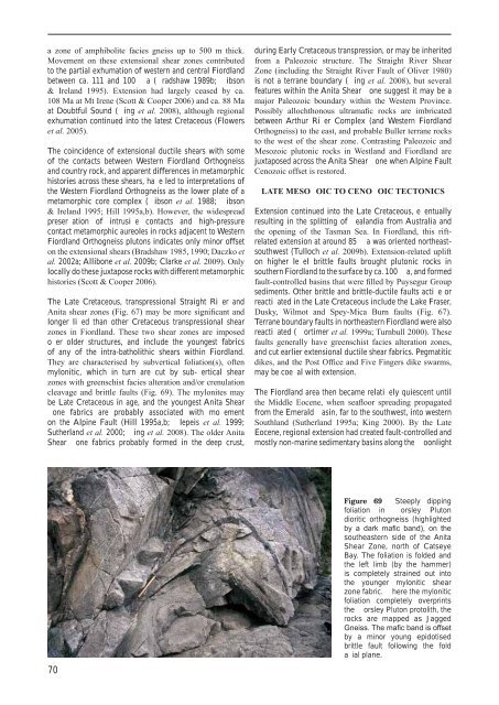
a zone <strong>of</strong> amphibolite facies gneiss up to 500 m thick.Movement on <strong>the</strong>se extensional shear zones contributedto <strong>the</strong> partial exhumation <strong>of</strong> western and central <strong>Fiordland</strong>between ca. 111 and 100 a ( radshaw 1989b; ibson& Ireland 1995). Extension had largely ceased by ca.108 Ma at Mt Irene (Scott & Cooper 2006) and ca. 88 Maat Doubtful Sound ( ing et al. 2008), although regionalexhumation continued into <strong>the</strong> latest Cretaceous (Flowerset al. 2005).The coincidence <strong>of</strong> extensional ductile shears with some<strong>of</strong> <strong>the</strong> contacts between Western <strong>Fiordland</strong> Orthogneissand country rock, and apparent differences in metamorphichistories across <strong>the</strong>se shears, ha e led to interpretations <strong>of</strong><strong>the</strong> Western <strong>Fiordland</strong> Orthogneiss as <strong>the</strong> lower plate <strong>of</strong> ametamorphic core complex ( ibson et al. 1988; ibson& Ireland 1995; Hill 1995a,b). However, <strong>the</strong> widespreadpreser ation <strong>of</strong> intrusi e contacts and high-pressurecontact metamorphic aureoles in rocks adjacent to Western<strong>Fiordland</strong> Orthogneiss plutons indicates only minor <strong>of</strong>fseton <strong>the</strong> extensional shears (Bradshaw 1985, 1990; Daczko etal. 2002a; Allibone et al. 2009b; Clarke et al. 2009). Onlylocally do <strong>the</strong>se juxtapose rocks with different metamorphichistories (Scott & Cooper 2006).The Late Cretaceous, transpressional Straight Ri er andAnita shear zones (Fig. 67) may be more significant andlonger li ed than o<strong>the</strong>r Cretaceous transpressional shearzones in <strong>Fiordland</strong>. These two shear zones are imposedo er older structures, and include <strong>the</strong> youngest fabrics<strong>of</strong> any <strong>of</strong> <strong>the</strong> intra-batholithic shears within <strong>Fiordland</strong>.They are characterised by subvertical foliation(s), <strong>of</strong>tenmylonitic, which in turn are cut by sub- ertical shearzones with greenschist facies alteration and/or crenulationcleavage and brittle faults (Fig. 69). The mylonites maybe Late Cretaceous in age, and <strong>the</strong> youngest Anita Shearone fabrics are probably associated with mo ementon <strong>the</strong> Alpine Fault (Hill 1995a,b; lepeis et al. 1999;Su<strong>the</strong>rland et al. 2000; ing et al. 2008). The older AnitaShear one fabrics probably formed in <strong>the</strong> deep crust,during Early Cretaceous transpression, or may be inheritedfrom a Paleozoic structure. The Straight River ShearZone (including <strong>the</strong> Straight River Fault <strong>of</strong> Oliver 1980)is not a terrane boundary ( ing et al. 2008), but severalfeatures within <strong>the</strong> Anita Shear one suggest it may be amajor Paleozoic boundary within <strong>the</strong> Western Province.Possibly allochthonous ultramafic rocks are imbricatedbetween Arthur Ri er Complex (and Western <strong>Fiordland</strong>Orthogneiss) to <strong>the</strong> east, and probable Buller terrane rocksto <strong>the</strong> west <strong>of</strong> <strong>the</strong> shear zone. Contrasting Paleozoic andMesozoic plutonic rocks in Westland and <strong>Fiordland</strong> arejuxtaposed across <strong>the</strong> Anita Shear one when Alpine FaultCenozoic <strong>of</strong>fset is restored.LATE MESO OIC TO CENO OIC TECTONICSExtension continued into <strong>the</strong> Late Cretaceous, e entuallyresulting in <strong>the</strong> splitting <strong>of</strong> ealandia from Australia and<strong>the</strong> opening <strong>of</strong> <strong>the</strong> Tasman Sea. In <strong>Fiordland</strong>, this riftrelatedextension at around 85 a was oriented nor<strong>the</strong>astsouthwest(Tulloch et al. 2009b). Extension-related uplifton higher le el brittle faults brought plutonic rocks insou<strong>the</strong>rn <strong>Fiordland</strong> to <strong>the</strong> surface by ca. 100 a, and formedfault-controlled basins that were filled by Puysegur Groupsediments. O<strong>the</strong>r brittle and brittle-ductile faults acti e orreacti ated in <strong>the</strong> Late Cretaceous include <strong>the</strong> Lake Fraser,Dusky, Wilmot and Spey-Mica Burn faults (Fig. 67).Terrane boundary faults in nor<strong>the</strong>astern <strong>Fiordland</strong> were alsoreacti ated ( ortimer et al. 1999a; Turnbull 2000). Thesefaults generally have greenschist facies alteration zones,and cut earlier extensional ductile shear fabrics. Pegmatiticdikes, and <strong>the</strong> Post Office and Five Fingers dike swarms,may be coe al with extension.The <strong>Fiordland</strong> area <strong>the</strong>n became relati ely quiescent until<strong>the</strong> Middle Eocene, when seafloor spreading propagatedfrom <strong>the</strong> Emerald asin, far to <strong>the</strong> southwest, into westernSouthland (Su<strong>the</strong>rland 1995a; King 2000). By <strong>the</strong> LateEocene, regional extension had created fault-controlled andmostly non-marine sedimentary basins along <strong>the</strong> oonlight70Figure 69 Steeply dippingfoliation in orsley Plutondioritic orthogneiss (highlightedby a dark mafic band), on <strong>the</strong>sou<strong>the</strong>astern side <strong>of</strong> <strong>the</strong> AnitaShear Zone, north <strong>of</strong> CatseyeBay. The foliation is folded and<strong>the</strong> left limb (by <strong>the</strong> hammer)is completely strained out into<strong>the</strong> younger mylonitic shearzone fabric. here <strong>the</strong> myloniticfoliation completely overprints<strong>the</strong> orsley Pluton protolith, <strong>the</strong>rocks are mapped as JaggedGneiss. The mafic band is <strong>of</strong>fsetby a minor young epidotisedbrittle fault following <strong>the</strong> folda ial plane.
Fault System from <strong>the</strong> Solander asin to nor<strong>the</strong>rn <strong>Fiordland</strong>(Norris Turnbull 1993; Turnbull et al. 1993; Su<strong>the</strong>rland& Melhuish 2000; Beggs & Ghisetti 2006). Extension,subsidence and marine sedimentation continued into <strong>the</strong>Oligocene o er most <strong>of</strong> sou<strong>the</strong>rn and eastern <strong>Fiordland</strong>,linked to similar basins on <strong>the</strong> West Coast (King 2000).Extension gradually became more dextral-oblique in<strong>the</strong> Late Oligocene, and although marine sedimentationcontinued in eastern <strong>Fiordland</strong>, local fault-related upliftresulted in minor unconformities.In <strong>the</strong> Early Miocene, <strong>the</strong> extensional regime changed totranspressional or obliquely con ergent (Walcott 1998;Su<strong>the</strong>rland et al. 2006b). Pre-existing, predominantlynormal faults became predominantly reverse and/or strikeslip,and basin e ersion began in <strong>the</strong> Waiau and Te Anaubasins. In <strong>the</strong> Middle Miocene, <strong>Fiordland</strong> began movingnorthward relati e to <strong>the</strong> Longwood and Takitimu ranges,with mo ement on <strong>the</strong> oonlight and Hollyford faultsystems, on faults in Fo eaux Strait (Turnbull et al. 1993),and on major brittle faults within <strong>Fiordland</strong>. The latterprobably included <strong>the</strong> reacti ated Dusky, Lake Fraserand Spey- ica urn faults, and nor<strong>the</strong>ast-trending faultsextending from Wet acket Arm to <strong>the</strong> Large urn (Fig.67).A consequence <strong>of</strong> obliquely con erging plate motionwas <strong>the</strong> initiation <strong>of</strong> a component <strong>of</strong> subduction south <strong>of</strong><strong>Fiordland</strong> in <strong>the</strong> iocene, which has since accelerated(Su<strong>the</strong>rland et al. 2006b). The Australian Plate has beenobliquely subducted to a depth <strong>of</strong> ca. 150 km (Eberhart-Phillips & Reyners 2001), although <strong>the</strong> total amount <strong>of</strong>inter-plate mo ement is much more (Su<strong>the</strong>rland et al. 2000).Subduction-related uplift, which began at ca.15 a aroundDusky Sound, propagated northward to reach nor<strong>the</strong>rn<strong>Fiordland</strong> in <strong>the</strong> Pliocene (House et al. 2005; R. Su<strong>the</strong>rland,pers. comm.). Late Cenozoic uplift is most pronounced inwestern <strong>Fiordland</strong>, west <strong>of</strong> <strong>the</strong> major intra-<strong>Fiordland</strong> faultslisted abo e, implying that <strong>the</strong>se ha e been acti e o er<strong>the</strong> past 5–15 million years. <strong>Fiordland</strong> has been uplifted,tilted and rotated, and its Cenozoic cover stripped away,in a series <strong>of</strong> discrete fault-bounded blocks, ra<strong>the</strong>r thandeforming as one rigid block. Late Cenozoic deformationis distributed among fault networks adjacent to <strong>the</strong> AlpineFault (Claypool et al. 2002), as well as localised on <strong>the</strong>Straight River and Anita shear zones (King et al. 2008).Although sou<strong>the</strong>rn <strong>Fiordland</strong> was relati ely quiescent in<strong>the</strong> Late iocene and Pliocene (Su<strong>the</strong>rland et al. 2006b),renewed Pliocene to Holocene shortening <strong>of</strong> <strong>the</strong> nor<strong>the</strong>rnSolander asin caused up to 20 km <strong>of</strong> strike-slip mo ementon <strong>the</strong> onshore Hauroko Fault, and closure <strong>of</strong> <strong>the</strong> WaitutuSub-basin along <strong>the</strong> Waitutu Thrust and Hump Ridgefaults (Turnbull ruski 1995; Su<strong>the</strong>rland et al. 2006b).Downfaulting <strong>of</strong> Cenozoic rocks into <strong>Fiordland</strong> basementalong NE- and NW-trending faults such as <strong>the</strong> Sandfly,iddle Fiord, and t Cuthbert faults, and <strong>the</strong> easternextension <strong>of</strong> <strong>the</strong> Dusky Fault (Zink 2000) dates fromlate Miocene and Pliocene time (Fig. 67). Basin closureand nor<strong>the</strong>asterly-directed shortening <strong>of</strong> between 50 and100 km has also affected nor<strong>the</strong>rn <strong>Fiordland</strong>, where most<strong>of</strong> <strong>the</strong> rook Street and aitai terranes ha e been excised.Within and east <strong>of</strong> <strong>the</strong> Anita Shear Zone, some Late Cenozoicplate boundary mo ement was also transmitted onto brittlefaults ( lepeis et al. 1999; Claypool et al. 2002).MODERN TECTONIC SETTING<strong>Fiordland</strong> now lies sou<strong>the</strong>ast <strong>of</strong> <strong>the</strong> Alpine Fault, <strong>the</strong> mostob ious and acti e expression <strong>of</strong> <strong>the</strong> boundary between<strong>the</strong> Pacific and Australian plates. The relative plate motionis highly oblique, with most mo ement being con ertedto dextral strike-slip on <strong>the</strong> Alpine Fault, and a smalleramount being absorbed by slip <strong>of</strong> <strong>the</strong> subducting AustralianPlate (Eberhart-Phillips Reyners 2001; arnes et al.2002; Reyners et al. 2002; Su<strong>the</strong>rland et al. 2006a). Thesubducted plate dips more steeply to <strong>the</strong> north beneathnor<strong>the</strong>rn <strong>Fiordland</strong>, and is sub- ertical below 75 km (seeFig. 73) down to ca. 150 km (Su<strong>the</strong>rland & Melhuish 2000;Eberhart-Phillips & Reyners 2001). The subducted slab isbent and torn (Reyners et al. 1991, 2002; Su<strong>the</strong>rland et al.2000; Eberhart-Phillips & Reyners 2001). Seismic activityin <strong>Fiordland</strong> occurs on and within arious segments <strong>of</strong><strong>the</strong> subducted Australian Plate, predominantly by normalfaulting abo e ca. 16 km, and by thrust faulting at greaterdepths (Reyners et al. 2002, 2003). Wedges <strong>of</strong> Holocenesediment <strong>of</strong>fshore are being deformed by shorteningimmediately west <strong>of</strong> <strong>the</strong> Alpine Fault, accommodatingas much as 20% <strong>of</strong> <strong>the</strong> modern plate motion ( arneset al. 2005). Subduction-related uplift at ca. 0.5 mm/yrcontinues in sou<strong>the</strong>rn and western <strong>Fiordland</strong>, as shownby marine sedimentary inliers (Turnbull et al. 2007) and<strong>the</strong> presence <strong>of</strong> raised marine benches ( im Su<strong>the</strong>rland2004; Fig. 63). The remainder <strong>of</strong> <strong>the</strong> plate boundarymotion is accommodated on <strong>the</strong> Alpine Fault, and onnearby subsidiary faults onland. These include <strong>the</strong> Fi eFingers and Two Fingers faults on Resolution Island, andacti e traces south <strong>of</strong> Dusky Sound and on Fi e FingersPeninsula. Rates <strong>of</strong> strike-slip mo ement on <strong>the</strong> AlpineFault vary from 23.1 ± 1.7 mm/yr in nor<strong>the</strong>rn <strong>Fiordland</strong>(Su<strong>the</strong>rland et al. 2006a) to an extreme 31.4 -3.5 2.1 mm/yr nearDoubtful Sound (Barnes 2009).71
- Page 1 and 2:
1 : 2 5 0 0 0 0 G e o l o g i c a l
- Page 3 and 4:
Geology of theFiordland AreaScale 1
- Page 5 and 6:
CONTENTSABSTRACT ..................
- Page 7 and 8:
FrontispieceA pekapeka (neck pendan
- Page 9 and 10:
Fiordland’s proximity to the acti
- Page 11 and 12:
INTRODUCTIONTHE QMAP SERIESThis geo
- Page 13 and 14:
ThesesPublished papersPublished map
- Page 15 and 16:
GEOMORPHOLOGYThe uplifted Fiordland
- Page 17 and 18:
TributaryglaciersTrunkglaciersQuate
- Page 19 and 20:
to 14 000 years BP, when the major
- Page 21 and 22:
Figure 10 A fossil marine arch, ero
- Page 23 and 24:
Figure 14 The northern Fiordland co
- Page 25 and 26:
STRATIGRAPHYPaleozoic metasedimenta
- Page 28 and 29:
ABCFigure 17 dgecumbe Group formati
- Page 30 and 31: thin marble (Fig. 18C), with interb
- Page 32 and 33: quartzofeldspathic biotite gneiss,
- Page 34 and 35: ACBFigure 23 Ordovician Fanny Bay G
- Page 36 and 37: Paleozoic metamorphic rocks of unce
- Page 38 and 39: 28PERMIAN TO URASSIC SEDIMENTARY AN
- Page 40 and 41: Figure 28 Latest Cambrian to earlie
- Page 42 and 43: etasedimentary xenoliths are common
- Page 44 and 45: Late Triassic to Cretaceous plutoni
- Page 46 and 47: heterogeneous, metre- to kilometre-
- Page 48 and 49: The Malaspina Pluton ( wm; 117-114
- Page 50 and 51: granite, leucogranite and tonalite
- Page 52 and 53: and comprises weakly foliated, loca
- Page 54 and 55: sedimentary rocks extend offshore t
- Page 56 and 57: AFigure 47 ocene sedimentary rocks
- Page 58 and 59: Figure 49 Oligocene sedimentary roc
- Page 60 and 61: graded sandstone and mudstone (Cart
- Page 62 and 63: sequence of Oligocene graded sandst
- Page 64 and 65: oup, and is restricted to the area
- Page 66 and 67: QUATERNARYExtensi e Quaternary depo
- Page 68 and 69: !!!!!!!!!!!!!!!!!!!!!! !!!! !! ! !!
- Page 70 and 71: y the present-day coast. The ice le
- Page 72 and 73: eorge Sound, and remnants of well-r
- Page 74 and 75: TECTONIC HISTORYFiordland has a lon
- Page 76 and 77: A B CDFigure 65 Fiordland plutonic
- Page 78 and 79: Major active faultsOffshore volcani
- Page 82 and 83: GEOLOGICAL RESOURCESAlmost the whol
- Page 84 and 85: HydrocarbonsSequences within the Cr
- Page 86 and 87: ENGINEERING GEOLOGYThis section pro
- Page 88 and 89: GEOLOGICAL HA ARDSThe numerous geol
- Page 90 and 91: NDCenozoic to Holocene faultsABCact
- Page 92 and 93: The most frequent landslide hazard
- Page 94 and 95: earthquakes along the Puysegur subd
- Page 96 and 97: ACNOWLEDGMENTSapping of Fiordland w
- Page 98 and 99: ishop, D. . 1991: High-le el marine
- Page 100 and 101: Ewing, T.A.; Weaver, S.D.; Bradshaw
- Page 102 and 103: Lee, W. .; Ward, C. .; Wilson, . .
- Page 104 and 105: Schacht, B. 1984: Interpretation re
- Page 106 and 107: Ward, C. . 1986: Speculations on th
- Page 108: The geology of Fiordland is describ