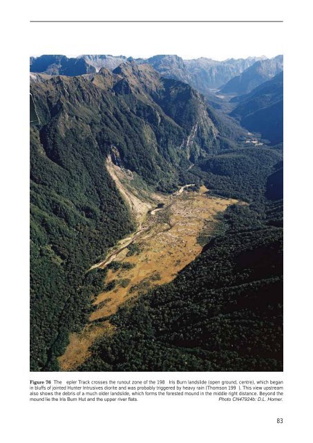
The most frequent landslide hazard in <strong>Fiordland</strong> is posedby hea y rain e ents. Nearly e ery rainstorm triggersshallow slope failures in steep, peaty soils that are poorlybonded to underlying rock, and usually laden with trees.Such landslides frequently block <strong>the</strong> ilford Road (e.g.Wandres et al. 1998), and both <strong>the</strong> Borland Saddle andWilmot Pass roads are <strong>of</strong>ten cut by minor rain-triggeredlandslides. Walking tracks and huts are also ulnerable(Thomson 1994; Fig. 76), but huts are normally re-sitedonce a landslide or a alanche risk has been recognised.Future large earthquakes (M7.5–8 or greater) on <strong>the</strong> AlpineFault and <strong>the</strong> subduction zone beneath <strong>Fiordland</strong> will almostcertainly trigger rock falls, rock slides and rock a alanchesthroughout <strong>Fiordland</strong>. ecause <strong>of</strong> <strong>the</strong>ir potentially greatersize, earthquake-triggered landslides (such as Green Lake;Hancox & Perrin 2009) present a greater hazard than raininducedlandslides to <strong>the</strong> ilford and o<strong>the</strong>r roads, mountainhuts and tracks, and tourist centres like ilford Sound.TsunamiFlooding and damage due to tsunami are possible alongall sea and lake shorelines within <strong>the</strong> <strong>Fiordland</strong> map area.Tsunami are generated by sudden large mo ements <strong>of</strong> <strong>the</strong>sea floor or lake beds, caused by local or distant earthquakes,submarine olcanic eruptions, submarine or sub-lacustrinelandslides, or delta collapse initiated by strong earthquakeshaking. Tsunami are known to ha e affected coastal<strong>Fiordland</strong> in about 1820 and 1826 (Downes et al. 2005).During <strong>the</strong> 2003 <strong>Fiordland</strong> earthquake, a rockfall into oldArm, Charles Sound, created a locally damaging tsunami4–5 m high (Fig. 77; Hancox et al. 2003). Tsunami damagefrom <strong>the</strong> 2009 earthquake, in contrast, was minimal (Wilsonet al. 2009).Tsunami generated by distant e ents take many hours toreach New Zealand, sufficient time for Civil Defence totake appropriate action. The risk from distant e ents isrelati ely low as <strong>the</strong>re are few potential sources in <strong>the</strong>sou<strong>the</strong>rn Tasman Sea. Locally generated tsunami are <strong>of</strong>more concern, as wa e heights may be large enough tobe damaging and life-threatening, possibly catastrophic,and tra el times too short for warnings to be issued. Localtsunami may persist for up to twel e hours, and distantsource tsunami for as long as three days. Tsunami may alsobe caused by landsliding into or beneath lakes followingearthquakes (Forsyth et al. 2006). A major rock fall intoany <strong>Fiordland</strong> lake could ha e potentially disastrousresults for lakeshore constructions and <strong>the</strong>ir occupants.The marine tsunami hazard in <strong>Fiordland</strong> was studied andmodelled by Downes et al. (2005). Their work suggests<strong>of</strong>fshore segments <strong>of</strong> <strong>the</strong> Alpine Fault may rupture in an7.8 earthquake and create tsunami up to 4 m high along<strong>the</strong> western <strong>Fiordland</strong> coast. The sou<strong>the</strong>rn coast may beaffected by tsunami <strong>of</strong> up to 4 m, emanating from majorFigure 75 Ridge rents at <strong>the</strong> head <strong>of</strong> an incipient major landslide, caused by gravitational collapse <strong>of</strong> glacially oversteepenedslopes north <strong>of</strong> Poteriteri Peak. Lake Poteriteri (right) is covered in fog.82
Figure 76 The epler Track crosses <strong>the</strong> runout zone <strong>of</strong> <strong>the</strong> 198 Iris Burn landslide (open ground, centre), which beganin bluffs <strong>of</strong> jointed Hunter Intrusives diorite and was probably triggered by heavy rain (Thomson 199 ). This view upstreamalso shows <strong>the</strong> debris <strong>of</strong> a much older landslide, which forms <strong>the</strong> forested mound in <strong>the</strong> middle right distance. Beyond <strong>the</strong>mound lie <strong>the</strong> Iris Burn Hut and <strong>the</strong> upper river flats.Photo CN47924b: D.L. Homer.83
- Page 1 and 2:
1 : 2 5 0 0 0 0 G e o l o g i c a l
- Page 3 and 4:
Geology of theFiordland AreaScale 1
- Page 5 and 6:
CONTENTSABSTRACT ..................
- Page 7 and 8:
FrontispieceA pekapeka (neck pendan
- Page 9 and 10:
Fiordland’s proximity to the acti
- Page 11 and 12:
INTRODUCTIONTHE QMAP SERIESThis geo
- Page 13 and 14:
ThesesPublished papersPublished map
- Page 15 and 16:
GEOMORPHOLOGYThe uplifted Fiordland
- Page 17 and 18:
TributaryglaciersTrunkglaciersQuate
- Page 19 and 20:
to 14 000 years BP, when the major
- Page 21 and 22:
Figure 10 A fossil marine arch, ero
- Page 23 and 24:
Figure 14 The northern Fiordland co
- Page 25 and 26:
STRATIGRAPHYPaleozoic metasedimenta
- Page 28 and 29:
ABCFigure 17 dgecumbe Group formati
- Page 30 and 31:
thin marble (Fig. 18C), with interb
- Page 32 and 33:
quartzofeldspathic biotite gneiss,
- Page 34 and 35:
ACBFigure 23 Ordovician Fanny Bay G
- Page 36 and 37:
Paleozoic metamorphic rocks of unce
- Page 38 and 39:
28PERMIAN TO URASSIC SEDIMENTARY AN
- Page 40 and 41:
Figure 28 Latest Cambrian to earlie
- Page 42 and 43: etasedimentary xenoliths are common
- Page 44 and 45: Late Triassic to Cretaceous plutoni
- Page 46 and 47: heterogeneous, metre- to kilometre-
- Page 48 and 49: The Malaspina Pluton ( wm; 117-114
- Page 50 and 51: granite, leucogranite and tonalite
- Page 52 and 53: and comprises weakly foliated, loca
- Page 54 and 55: sedimentary rocks extend offshore t
- Page 56 and 57: AFigure 47 ocene sedimentary rocks
- Page 58 and 59: Figure 49 Oligocene sedimentary roc
- Page 60 and 61: graded sandstone and mudstone (Cart
- Page 62 and 63: sequence of Oligocene graded sandst
- Page 64 and 65: oup, and is restricted to the area
- Page 66 and 67: QUATERNARYExtensi e Quaternary depo
- Page 68 and 69: !!!!!!!!!!!!!!!!!!!!!! !!!! !! ! !!
- Page 70 and 71: y the present-day coast. The ice le
- Page 72 and 73: eorge Sound, and remnants of well-r
- Page 74 and 75: TECTONIC HISTORYFiordland has a lon
- Page 76 and 77: A B CDFigure 65 Fiordland plutonic
- Page 78 and 79: Major active faultsOffshore volcani
- Page 80 and 81: a zone of amphibolite facies gneiss
- Page 82 and 83: GEOLOGICAL RESOURCESAlmost the whol
- Page 84 and 85: HydrocarbonsSequences within the Cr
- Page 86 and 87: ENGINEERING GEOLOGYThis section pro
- Page 88 and 89: GEOLOGICAL HA ARDSThe numerous geol
- Page 90 and 91: NDCenozoic to Holocene faultsABCact
- Page 94 and 95: earthquakes along the Puysegur subd
- Page 96 and 97: ACNOWLEDGMENTSapping of Fiordland w
- Page 98 and 99: ishop, D. . 1991: High-le el marine
- Page 100 and 101: Ewing, T.A.; Weaver, S.D.; Bradshaw
- Page 102 and 103: Lee, W. .; Ward, C. .; Wilson, . .
- Page 104 and 105: Schacht, B. 1984: Interpretation re
- Page 106 and 107: Ward, C. . 1986: Speculations on th
- Page 108: The geology of Fiordland is describ